FREE! Click here to Join FunTrivia. Thousands of games, quizzes, and lots more!
Quiz about From One Extreme to the Other

From One Extreme to the Other! Quiz


I'd like to relax on a tropical beach but my travel agent has other ideas. He likes to surprise me with trips from one extreme site to another. Can you tell me where I am now and where my agent is sending me to next?

A photo quiz by Tizzabelle. Estimated time: 6 mins.
  1. Home
  2. »
  3. Quizzes
  4. »
  5. Geography Trivia
  6. »
  7. Where on Earth?
  8. »
  9. Where am I?

Author
Tizzabelle
Time
6 mins
Type
Photo Quiz
Quiz #
359,856
Updated
Dec 03 21
# Qns
10
Difficulty
Tough
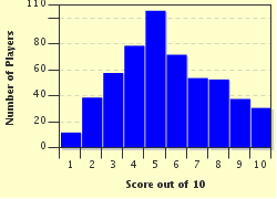
Avg Score
6 / 10
Plays
2047
Awards
Top 5% quiz!
Last 3 plays: Guest 73 (4/10), Guest 195 (4/10), Creedy (8/10).
-
Question 1 of 10
1. I'm in a country which houses the world's tallest mountain, but my travel agent thinks the air is too thin. He's sending me to the lowest point of the earth's surface for a change. He thinks I'll like floating in a very salty lake. Which country am I in, and where am I going to? Hint


Question 2 of 10
2. It's nothing but extremes with my travel agent. First he landed me in the driest place on Earth where it might not rain for a century or more. Now he's sending me to the deepest river on Earth. If I sink the boat I'll be in, it's over 200 metres to the river bed. Where am I, and where am I going? Hint


Question 3 of 10
3. I've walked around the smallest country on Earth. It didn't take long as it's less than one square kilometre in area. Now I'm going to the capital city of the largest province in Canada. Where am I, and where am I going? Hint


Question 4 of 10
4. I'm now in the capital of a country which lies on the Greenwich Meridian. My travel agent is now sending me to the capital of a country which lies on the Equator. Where am I, and where am I going? Hint


Question 5 of 10
5. I'm in a country which has its lowest point 1,400 metres above sea level. I'm off to the country with a highest point of only 2.4 metres. Where am I and where am I going? Hint


Question 6 of 10
6. My travel agent certainly wants me to see the world. This time I'm in the capital of one doubly landlocked country. For my next destination he's sending me to the capital of the only other doubly landlocked country in the world. Where am I, and where am I going? Hint


Question 7 of 10
7. I've had a great time visiting this capital city as I could hop over the border and visit any of the fourteen countries with which its nation shares a land border. It's the country which celebrated the Olympic Games in the stadium in the photo. Now I'm going to a state in the United States which has eight neighbours. Where am I now and where am I going? Hint


Question 8 of 10
8. I'm at the highest point of South America and my travel agent has booked me a ticket to visit the lowest point of South America which is a salt lake. The photo is the coat of arms of the regional government area in which the lowest point is located. Which country am I in, and where am I heading next? Hint


Question 9 of 10
9. My travel agent wants me to go climbing this time. I'm at the lowest point of Africa and now I have to climb the tallest mountain located on an island rather than on a continental landmass. Where am I now and to which island am I going? Hint


Question 10 of 10
10. My travel agent must think I'm an ichthyologist. I'm on the shore of the world's deepest lake watching the native seals and now my agent is now sending me to the lake with the biggest variety of fish species. Where am I now, and where am I going? Hint


(Optional) Create a Free FunTrivia ID to save the points you are about to earn:

arrow Select a User ID:
arrow Choose a Password:
arrow Your Email:


View Image Attributions for This Quiz

Most Recent Scores
Apr 18 2024 : Guest 73: 4/10
Apr 04 2024 : Guest 195: 4/10
Mar 26 2024 : Creedy: 8/10
Mar 26 2024 : Hando: 4/10
Mar 07 2024 : Joepetz: 6/10
Mar 07 2024 : Kankurette: 9/10
Mar 07 2024 : patrickk: 10/10
Mar 04 2024 : Guest 65: 7/10
Mar 04 2024 : Guest 87: 3/10

Score Distribution

quiz
Quiz Answer Key and Fun Facts
1. I'm in a country which houses the world's tallest mountain, but my travel agent thinks the air is too thin. He's sending me to the lowest point of the earth's surface for a change. He thinks I'll like floating in a very salty lake. Which country am I in, and where am I going to?

Answer: Nepal to Jordan

Mount Everest in Nepal is the highest mountain on Earth. If you've climbed down from the peak to the Everest Base Camp, you'll have to descend even further to reach the nearest airport. Syangboche Airport is 3,780m (12,402 ft) above sea level. It's not an airport really; it's more of a strip of dirt which has been cleared and flattened. The flights to and from Syangboche Airport are chartered flights either with helicopters or aeroplanes capable of landing and taking off in limited conditions. No regular services are operated there, but I'm sure my travel agent has chartered a flight for me. The photo is of Mt Everest.

My next stop is the Dead Sea, the lowest point of land on Earth. The Israeli and Jordanian shoreline of the Dead Sea is a mere 423 metres (1,388 ft) below sea level. The salt concentration in the Dead Sea's waters is over eight times that of the ocean. I would most probably land (in my chartered plane), at Queen Alia International Airport in Jordan, just 32 km (20 mi) south of Amman. I'll enjoy the facilities of the airport which had a terminal officially opened in March, 2013. From the airport, it's roughly 30 km (18 mi) to the Dead Sea. The distance I travelled between the airports was a mere 4,877 km (3,030 mi).
2. It's nothing but extremes with my travel agent. First he landed me in the driest place on Earth where it might not rain for a century or more. Now he's sending me to the deepest river on Earth. If I sink the boat I'll be in, it's over 200 metres to the river bed. Where am I, and where am I going?

Answer: Chile to the Congo River

I'm in Antofagasta, Chile, about 1,100 km (700 mi) north of Santiago, Chile's capital. The city heavily relies on the mining industry located in the Atacama Desert. The desert covers an area over 100,000 sq. km (40,000 sq. mi), but differing opinions exist as to the exact area it covers. Some experts say it is all in Chile, while others feel it ranges into Peru, Argentina and/or Bolivia. The landscape has similarities with Mars and NASA conducted trials of their space equipment in the Atacama.

Rising out of the desert, Antofagasta has both harbour facilities and an airport, the Cerro Moreno International Airport. From here, I'll catch a flight to Kinshasa, the capital of the Democratic Republic of the Congo. The city is located on the Congo River and right across the river, almost within a stone's throw, is the capital of the Republic of the Congo, Brazzaville. They are the two capital cities closest to each other in the world. To get from Antofagasta on the west coast of South America to Kinshasa International Airport, I need to fly 9,405 km (5,844 mi).

The Congo River begins life in the highlands of the East African Rift, travelling 4,700 km (2,920 mi) before it enters the Atlantic Ocean at Muanda in the Democratic Republic of the Congo. The volume of water in the river doesn't vary widely through the year due to the river's location. Its catchment area is so large and being spread over the equator, one part of the catchment area will be experiencing a rainy season when others aren't. The Congo River has one of the highest volumes of flow in world with some references saying it's the second highest flow of any river after the Amazon, while others cite the Congo as having the third largest volume of water.

The photo is of the Congo River. In bottom, left hand corner you can see an urban area. That is Kinshasa. On the other side of the river is Brazzaville.
3. I've walked around the smallest country on Earth. It didn't take long as it's less than one square kilometre in area. Now I'm going to the capital city of the largest province in Canada. Where am I, and where am I going?

Answer: Vatican City to Quebec City

Vatican City, also properly known as The Holy See, encompasses a total area of only 44 hectares (109 acres). Located within the city of Rome, Italy, it has been its own nation since 1929. It would rely on Italy for defence should the need arise, uses the Euro for currency, but Vatican City does issue its own stamps. Vatican City is the home of the Pope and is the spiritual home of the Roman Catholic Church.

Quebec City, also known simply as Quebec, is the capital of Quebec, Canada's largest province. The province covers 1,542,056 sq. km (595,391 sq. mi) making it the largest of Canada's ten provinces. The territory of Nunavut is larger than Quebec though. The city of Quebec, with a population of just over half a million people isn't the largest in Quebec. That honour goes to Montreal with its population of over three million people.

To fly from one extreme to the other, I'll need to travel 6,359 km (3,951 mi) as the crow flies. Vatican City doesn't have an airport but there is a heliport. If I can't catch a chopper, I could take a plane from Rome's Leonardo da Vinci-Fiumincino Airport all the way to Quebec City's Jean Lesage International Airport. The distance I'll need to conquer between these two destinations is 6,366 km, or 3,955 miles.

The photo is of a bus and train station in Quebec City. Ah, why don't they build buildings like that any more?
4. I'm now in the capital of a country which lies on the Greenwich Meridian. My travel agent is now sending me to the capital of a country which lies on the Equator. Where am I, and where am I going?

Answer: Algiers to Kampala

There are only eight countries that lie on the Greenwich (or Prime) Meridian. They are, from north to south; The UK, France, Spain, Algeria, Mali, Burkina Faso, Ghana, Togo. In contrast, there are eleven countries which straddle the Equator. They are, heading east from the Atlantic Ocean; Sao Tome and Principe, Gabon, Republic of the Congo, Democratic Republic of the Congo, Uganda, Kenya, Somalia, Indonesia, Ecuador, Colombia and Brazil.

I'm in Algiers, the capital of Algeria. Located on the Mediterranean Sea, there have been people living in the area since well before ancient Roman times, even dating back to 2,000 years before the Romans. Algiers has seen the influence of the Spanish, the Zirids, the Hammadids, the Ottomans and others over the last couple of millennia. The city as we know it today can be said to have been founded in 944 AD by Bologhine ibn Ziri.

Kampala, the capital of Uganda, was once a region of hills and marshland, rich with game for hunting. The city's name is derived from the local words for "hill of the impala'. Now a city with over a million people, it lies very close to the northern shore of Lake Victoria.

Houari Boumediene Airport serves Algiers and it's only 5,072 km (3,152mi) from there to Entebbe Airport, Kampala, which functions as the largest airport in Uganda. While I'm in Kampala, I can visit the Kasubi Tombs in the photo. These are tombs built in the 19th century for tribal kings, and the site is now a UNESCO World Heritage Site.
5. I'm in a country which has its lowest point 1,400 metres above sea level. I'm off to the country with a highest point of only 2.4 metres. Where am I and where am I going?

Answer: Lesotho to Maldives

It's easy enough to quote Maldives as the country with the lowest high point, but it's not often you think of the country with the highest low point. This means the country's lowest point above sea level is higher than any other country's low point. This honour goes to Lesotho. Lesotho is a landlocked nation completely surrounded by South Africa. This roughly rectangular-shaped country has an area of 30,355 sq. km (11,720 sq. mi) and a border with South Africa of 909 km (565 mi).

The lowest point of Lesotho is where the Orange and Makhaleng Rivers meet. This point is 1,400m above sea level. This altitude gives Lesotho a cooler, wetter climate than other parts of the world at similar latitudes. The highest point is Thabana Ntlenyana, a mountain in the Drakensburg Mountains which reaches 3,482m (11,424 ft) above sea level. The highest point in all of southern Africa, Thabana Ntlenyana's name means 'beautiful little mountain'. The photo is of Maseru, the capital, and its surrounds.

In sharp contrast to Lesotho is Maldives, an independent republic in the Indian Ocean known for its tropical splendour. It's also known for its lack of mountains. The highest point of Maldives is a scant 2.4 metres (8 ft) above sea level on one of the atolls that make up the Maldives. This point doesn't even have a name. Maldives is made up of over one thousand coral islands which form 26 atolls. Located in the Indian Ocean southwest of India, the climate is warm to hot, and humid so you won't need your snow gear and crampons if you feel like scaling Maldives' tallest peak.

Moshoeshoe I Airport services Lesotho at its facilities close to Maseru. From there, I'll fly to Ibrahim Nasir International Airport otherwise known as Male International Airport. It's the primary international airport of Maldives and located in Male, the capital. It's only 6,169 km, or 3,833 miles between aerodromes.
6. My travel agent certainly wants me to see the world. This time I'm in the capital of one doubly landlocked country. For my next destination he's sending me to the capital of the only other doubly landlocked country in the world. Where am I, and where am I going?

Answer: Vaduz to Tashkent

A landlocked country is one that has no coastline on an open sea or ocean. A doubly landlocked country is one which is surrounded by countries which are also landlocked. Therefore, in order to get to the ocean, a person must cross at least two borders before they can paddle in an open ocean or sea. There are only two of these countries. One is Liechtenstein (capital, Vaduz) and the other is Uzbekistan whose capital is Tashkent.

Vaduz is located in west-central Liechtenstein, the tiny country snuggled between Austria and Switzerland. There is no airport in the country, the railway system totalled 9km of track in 2013, but bus services are frequent. Vaduz has a population of only about 5,000 people. To catch a plane to Tashkent, I'll need to go to the nearest airport which is near Hohenems, a town in Austria. From there, I'll fly 4,678 km (2,906 mi) to Tashkent International Airport in Uzbekistan. The photo shows Vaduz Castle with Vaduz in the background.

Tashkent's history stretches back to at least the third century B.C.. It has been attacked and/or conquered by Mongols, Turks, Uzbeks, the Khorezmshah and others, but is now the capital of the Republic of Uzbekistan. Located in the far eastern part of Uzbekistan on a rich, alluvial plain, Tashkent essentially has a Mediterranean climate but with colder winters than the Mediterranean experiences. Tashkent has a little over two million people within its city limits.
7. I've had a great time visiting this capital city as I could hop over the border and visit any of the fourteen countries with which its nation shares a land border. It's the country which celebrated the Olympic Games in the stadium in the photo. Now I'm going to a state in the United States which has eight neighbours. Where am I now and where am I going?

Answer: Beijing to Tennessee

Beijing is the capital of China which has fourteen neighbouring countries. This makes China the most neighbourly of countries, tied with Russia which also has fourteen neighbours. China's neighbours are Afghanistan, Bhutan, Burma, India, Kazakhstan, North Korea, Kyrgyzstan, Laos, Mongolia, Nepal, Pakistan, Russia, Tajikistan, and Vietnam! The longest border is with Mongolia which stretches for 4,677 km (2,906 mi). The photo is of the Bird's Nest Stadium, Beijing, built for the 2008 Olympic Games.

Both Tennessee and Missouri have eight neighbouring states so either state could have been the correct answer to the last part of the question. Tennessee's neighbours are (starting from the north and going clockwise) Kentucky, Virginia, North Carolina, Georgia, Alabama, Mississippi, Arkansas, and Missouri.

Tennessee's capital city is Nashville and there is an international airport there. If I fly from the Beijing Capital International Airport to Nashville International Airport, I will cover 11,227 km, or 6,976 miles!
8. I'm at the highest point of South America and my travel agent has booked me a ticket to visit the lowest point of South America which is a salt lake. The photo is the coat of arms of the regional government area in which the lowest point is located. Which country am I in, and where am I heading next?

Answer: Argentina and I'll stay in Argentina

Mount Aconcagua in Argentina is South America's highest point at 6,960 m (22,837 ft) above sea level. It's also the higher than any mountain in North or Central America. My travel agent thinks it's amusing that I can go from one extreme to the other in the same country as he also found South America's lowest point in Argentina.

Laguna del Carbon is South America's lowest point and is found in the south of Argentina 1,889 km (1,174 mi) from Mt Aconcagua. Laguna del Carbon is a salt lake which sits 105 m (344 ft) below sea level. It's lower than the USA's Death Valley and is the lowest point in the Americas and the Southern Hemisphere. Located in Santa Cruz province, Laguna del Carbon lies in the huge Patagonia geographic region which stretches over Chile and Argentina. The coat of arms depicts Mount Fitz Roy located in the western portion of Santa Cruz near the border with Chile.
9. My travel agent wants me to go climbing this time. I'm at the lowest point of Africa and now I have to climb the tallest mountain located on an island rather than on a continental landmass. Where am I now and to which island am I going?

Answer: Djibouti to New Guinea

Lake Assal, Djibouti, is in the desert at the northern end of the Great Rift Valley. A highly saline lake, it is saltier than the Dead Sea and ten times as salty as an ocean. It's relatively small, only 54 sq km in surface area, and has a maximum depth of 40m. The shoreline of Lake Assal is 155 m (509 ft) below sea level making it the lowest point in Africa. It's also the third lowest point in the world, only the Dead Sea and the Sea of Galilee being lower than Lake Assal. From there I'm going to Puncak Jaya on the island of New Guinea.

Puncak Jaya is the highest mountain on an island. It's tempting to think of Mauna Loa or other Hawaiian mountains being the highest, but it's on tropical New Guinea, the second largest island in the world. The mountain is found in the Sudirman Range in the Indonesian portion of New Guinea. Created by the meeting of two tectonic plates (the Australian and Pacific), the mountain rises 4,884 m (16,024 ft) above sea level. This is higher than Mount Whitney in the USA or Mont Blanc in Europe.

The closest airport to Puncak Jaya is 42 km (26 mi) away. Called Zugapa Airport, it's a strip of tarmac laid down on a flat strip of land in the highlands. Surrounded by mountains, it can't be an easy landing, especially after my flight from Tadjoura Airpot in Djibouti. It was only 10,553 km (6,558 mi), but that's long enough in a small plane, the only ones capable of landing there.
10. My travel agent must think I'm an ichthyologist. I'm on the shore of the world's deepest lake watching the native seals and now my agent is now sending me to the lake with the biggest variety of fish species. Where am I now, and where am I going?

Answer: Lake Baikal to Lake Malawi

Irkutsk is a city on the southwestern shore of Lake Baikal. It's found on the Angara River, a river which drains the massive Lake Baikal. Located in Siberia, Lake Baikal is the deepest and oldest lake on Earth, and home to thousands of species of animals and plants including the Baikal seal. The smallest of the true seals, its mystery is how it came to live and flourish in a lake hundreds of kilometres from any ocean. It is one of the very few species of pinnipeds which can thrive in fresh water. The majority of the flora and fauna in the area are endemic, not being found anywhere else on the planet. Lake Baikal contains about 20% of all the world's fresh, unfrozen water, and at its deepest, it's just over one mile deep at 1,642 m or 5,387 ft deep with a surface area of 31,722 sq. km (12,248 sq. mi).

There is an international airport in Irkutsk from which I'll take a plane to Lake Malawi. Likoma Airport is located on Likoma Island in Lake Malawi. Likoma and Chizumulu Islands form the Likoma district of Malawi, but they are surrounded by the territorial waters of Malawi's neighbour, Mozambique. Lake Malawi covers 29,600 sq. km (11,400 sq. mi), but Likoma Island covers only 18 sq. km. In Lake Malawi, I can find thousands of fish species. There are over 1,000 species of chiclids alone. To get between the two airports, I travelled 9,747 km (6057 mi).

The photo is of a Baikal seal, taken at a museum in Irkutsk.
Source: Author Tizzabelle

This quiz was reviewed by FunTrivia editor Pagiedamon before going online.
Any errors found in FunTrivia content are routinely corrected through our feedback system.
4/23/2024, Copyright 2024 FunTrivia, Inc. - Report an Error / Contact Us