FREE! Click here to Join FunTrivia. Thousands of games, quizzes, and lots more!
Quiz about The Andaman  Nicobar Islands of India

The Andaman & Nicobar Islands of India Quiz


When one thinks of India, the massive mainland country is probably what comes to mind. This quiz tests players' knowledge on another part of India, namely the Andaman and Nicobar Islands. Best of luck.

A multiple-choice quiz by Triviaballer. Estimated time: 5 mins.
  1. Home
  2. »
  3. Quizzes
  4. »
  5. Geography Trivia
  6. »
  7. India
  8. »
  9. States and Cities Individual Regions

Author
Triviaballer
Time
5 mins
Type
Multiple Choice
Quiz #
270,490
Updated
May 31 22
# Qns
15
Difficulty
Tough
Avg Score
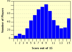
9 / 15
Plays
2806
Awards
Top 20% Quiz
Last 3 plays: Guest 157 (7/15), Guest 1 (15/15), Sethdv7 (14/15).
- -
Question 1 of 15
1. In what body of water, itself a part of the Indian Ocean, are the Andaman and Nicobar Islands located? Hint


Question 2 of 15
2. What line of latitude separates the Andaman Islands from the Nicobar Islands? Hint


Question 3 of 15
3. In what time zone of the Coordinated Universal Time system (UTC) are the Andaman and Nicobar Islands? Hint


Question 4 of 15
4. What type of sub-national administrative division within India are the Andaman and Nicobar Islands? Hint


Question 5 of 15
5. What town is both the capital and the most populous city of the Andaman and Nicobar Islands? Hint


Question 6 of 15
6. From what language are the names of the Andaman and Nicobar Islands derived? Hint


Question 7 of 15
7. What chain of islands, belonging to Myanmar, is separated by a narrow 40 kilometer channel from the northernmost Andaman island? Hint


Question 8 of 15
8. There are a total of 576 islands in the Andaman Islands. Twenty-six of these are inhabited and five of these 26 are considered major islands. Of the following, which is NOT one of the five major Andaman Islands? Hint


Question 9 of 15
9. The Andaman Islands are separated from the Nicobar Islands by this waterway that has a width of about 150 kilometers. Hint


Question 10 of 15
10. The Nicobar Islands comprise an area about one-fourth of that of the Andaman Islands. How many islands are there in total in the Nicobar Islands? Hint


Question 11 of 15
11. In the 1850s, the indigenous populations of the Andaman and Nicobar Islands came into direct contact with Europeans for the first time. Which of the following ethnic groups became extinct before India achieved its independence in 1947? Hint


Question 12 of 15
12. What nation invaded the Andaman Islands in 1942 and established a military base at Port Blair that lasted for over three years? Hint


Question 13 of 15
13. On December 26th of what year did an earthquake in the Indian Ocean cause a tsunami that reached heights of 10 meters and took the lives 7,000 people of the Andaman and Nicobar Islands? Hint


Question 14 of 15
14. With a height of 732 meters above sea level, this mountain is the highest point of the Andaman and Nicobar Islands. Hint


Question 15 of 15
15. An airport located in Port Blair with an IATA airport code of IXZ provides transportation from the Andaman Islands to two major cities of mainland India. What two mainland cities of India does IXZ serve? Hint


(Optional) Create a Free FunTrivia ID to save the points you are about to earn:

arrow Select a User ID:
arrow Choose a Password:
arrow Your Email:


Most Recent Scores
Apr 10 2024 : Guest 157: 7/15
Apr 08 2024 : Guest 1: 15/15
Mar 30 2024 : Sethdv7: 14/15
Mar 30 2024 : johnnycat777: 9/15
Mar 30 2024 : wjames: 5/15
Mar 14 2024 : Guest 117: 13/15
Mar 08 2024 : Guest 106: 10/15
Feb 28 2024 : Guest 45: 0/15
Feb 27 2024 : panagos: 3/15

Score Distribution

quiz
Quiz Answer Key and Fun Facts
1. In what body of water, itself a part of the Indian Ocean, are the Andaman and Nicobar Islands located?

Answer: Bay of Bengal

With an area of 2,170,000 square kilometers, the Bay of Bengal is one of the largest non-ocean bodies of water in the world. Several major rivers including the Irawaddy, Brahmaputra, and Ganges drain into the Bay of Bengal. The Andaman Sea lies to the east of the Andaman and Nicobar Islands.
2. What line of latitude separates the Andaman Islands from the Nicobar Islands?

Answer: 10° N

Many heavily populated cities in Asia and Africa lie near the 10° N parallel. The Nicobar Islands lie just south of this line while the Andaman Islands lie to the north.
3. In what time zone of the Coordinated Universal Time system (UTC) are the Andaman and Nicobar Islands?

Answer: UTC+5:30

All of India, including the Andaman and Nicobar Islands, is considered part of the UTC+5:30 time zone. This is commonly referred to as Indian Standard Time (IST).
4. What type of sub-national administrative division within India are the Andaman and Nicobar Islands?

Answer: Union Territory

The nation of India is a federal republic comprised of twenty-eight states and six union territories. Many of the states are additionally subdivided into divisions, districts, and Tehsils. The other six union territories of India are Chandigarh, Dadra and Nagar Haveli, Daman and Diu, Lakshadweep, and Puducherry.
5. What town is both the capital and the most populous city of the Andaman and Nicobar Islands?

Answer: Port Blair

With a population of 100,000, Port Blair comprises over one-fourth of the islands' total population. The town was named in the late 1700s for a British East India Company Lieutenant named Archibald Blair. Port Blair served as a penal colony from 1858 to the early 1900s. Port Blair functioned as the headquarters of the Indian National Army under president Subhas Chandra Bose in 1943 and 1944.
6. From what language are the names of the Andaman and Nicobar Islands derived?

Answer: Malay

'Andaman' is derived from the Malay word for the Hindu god Hanuman. 'Nicobar' is a Malay word that roughly translates to 'land of the naked people.'
7. What chain of islands, belonging to Myanmar, is separated by a narrow 40 kilometer channel from the northernmost Andaman island?

Answer: Coco Islands

The Coco Channel separates North Andaman Island from Little Coco Island. Great Coco Island, located 15 kilometers northeast of Little Coco Island, is a popular nesting ground for green turtles.
8. There are a total of 576 islands in the Andaman Islands. Twenty-six of these are inhabited and five of these 26 are considered major islands. Of the following, which is NOT one of the five major Andaman Islands?

Answer: West Andaman

The other two major islands are North Andaman and South Andaman. The total length of the Andaman Islands is 352 kilometers and the islands' land area is 6,408 square kilometers.
9. The Andaman Islands are separated from the Nicobar Islands by this waterway that has a width of about 150 kilometers.

Answer: Ten Degree Channel

As you may have guessed, the Ten Degree Channel lies on the 10° N line of latitude. The Strait of Malacca separates West Malaysia from the island of Sumatra. The Palk Strait separates India and Sri Lanka. The Bab-el-Mandeb separates Yemen and Djibouti.
10. The Nicobar Islands comprise an area about one-fourth of that of the Andaman Islands. How many islands are there in total in the Nicobar Islands?

Answer: 22

The largest island is Great Nicobar which has an area of 1045 kmē, about 57% of the total area of the Nicobar Islands. Ten of the 22 islands are uninhabited. The other major Nicobar Islands are Katchal, Camorta, Nancowry, Trinket, and Little Nicobar.
11. In the 1850s, the indigenous populations of the Andaman and Nicobar Islands came into direct contact with Europeans for the first time. Which of the following ethnic groups became extinct before India achieved its independence in 1947?

Answer: Jangil

Newly introduced diseases were probably the major reason for the death of the Jangil people. In the 1920s, an expedition attempted to find signs that the Jangil people were still alive, but it was unsuccessful. As of 2007, the Shompen people of the Nicobar Islands had a population of about 400 and the Jarawa people of the Andaman Islands had a population of about 300.

The Sentinelese people of the Andaman Islands are a very isolated group and their population may be as low as 40 or as high as 500.
12. What nation invaded the Andaman Islands in 1942 and established a military base at Port Blair that lasted for over three years?

Answer: Japan

The British army had a difficult time defending its overseas territories during World War II. The Andaman islands were invaded and occupied by Japanese forces on March 23, 1942. Little is known of the Japanese occupation of the islands because the majority of the government records were burned in 1945.
13. On December 26th of what year did an earthquake in the Indian Ocean cause a tsunami that reached heights of 10 meters and took the lives 7,000 people of the Andaman and Nicobar Islands?

Answer: 2004

The 2004 Indian Ocean Earthquake created a series of tsunamis that claimed approximately 200,000 lives. The earthquake had a magnitude of 9.2 making it the second largest earthquake ever recorded on a seismograph.
14. With a height of 732 meters above sea level, this mountain is the highest point of the Andaman and Nicobar Islands.

Answer: Saddle Peak

Saddle Peak is located near Kalipur beach on North Andaman. Narcondam is an extinct volcano located in the Andaman Sea. Mount Thullier rises 642 meters above sea level and is the highest point of the Nicobar Islands. Indira Point, located on Great Nicobar Island, is the most southern point in all of India.
15. An airport located in Port Blair with an IATA airport code of IXZ provides transportation from the Andaman Islands to two major cities of mainland India. What two mainland cities of India does IXZ serve?

Answer: Kolkata (Calcutta) and Chennai (Madras)

Chennai is the capital of the Indian state of Tamil Nadu and is located 1,190 kilometers from Port Blair. Kolkata is the capital of the Indian state of West Bengal and is located 1,255 miles from Port Blair.
Source: Author Triviaballer

This quiz was reviewed by FunTrivia editor Leau before going online.
Any errors found in FunTrivia content are routinely corrected through our feedback system.
Related Quizzes
This quiz is part of series Island Hopping (1):

Some quizzes on islands of the world

  1. Bahrain Average
  2. The Andaman & Nicobar Islands of India Tough
  3. Dry Tortugas - The End of the Florida Keys Average
  4. Saint Pierre and Miquelon Tough
  5. Aleutian Islands Average

4/16/2024, Copyright 2024 FunTrivia, Inc. - Report an Error / Contact Us