FREE! Click here to Join FunTrivia. Thousands of games, quizzes, and lots more!
Quiz about Marine Navigation

Marine Navigation Trivia Quiz


The ancient art and science of marine navigation.

A multiple-choice quiz by wjames. Estimated time: 5 mins.
  1. Home
  2. »
  3. Quizzes
  4. »
  5. Science Trivia
  6. »
  7. Miscellaneous Science

Author
wjames
Time
5 mins
Type
Multiple Choice
Quiz #
353,333
Updated
Dec 03 21
# Qns
10
Difficulty
Tough
Avg Score
6 / 10
Plays
478
Last 3 plays: Guest 136 (4/10), Guest 174 (2/10), Guest 207 (4/10).
- -
Question 1 of 10
1. Nathaniel Bowditch wrote this authoritative text on marine navigation in 1802, and it's still in use today. What is it? Hint


Question 2 of 10
2. Cartographer Gerardus ________ first used the term "atlas" for a book of maps, and developed an accurate way to show the surface of a sphere on a flat, rectangular map with the least distortion. Hint


Question 3 of 10
3. Aboard U.S. Navy ships, enlisted navigation specialists are known as ________ . Hint


Question 4 of 10
4. A navigation device used to plot horizontal sextant angles on a chart to obtain a "fix" of the ship's location is a _____. Hint


Question 5 of 10
5. Large-area rotating ocean currents that are caused by prevailing winds and the Coriolis Effect are _____. Hint


Question 6 of 10
6. The determination of _____ at sea couldn't be readily determined until an accurate timepiece, the marine chronometer, was developed. Hint


Question 7 of 10
7. Although a _____ route follows the shortest distance between points on the globe, it is difficult to steer so ships usually break the route into a series of straight rhumb line sections. Hint


Question 8 of 10
8. A _____ is a simple hand-held device used to estimate the observer's distance from an object of known height; this instrument was also used in submarine periscopes. Hint


Question 9 of 10
9. A map of the sea bed and shoreline, used for marine navigation, is known as a _____. Hint


Question 10 of 10
10. Nautical charts that show the most detail of a small area, such as a port or internal waterway, are ____ scale charts. Hint


(Optional) Create a Free FunTrivia ID to save the points you are about to earn:

arrow Select a User ID:
arrow Choose a Password:
arrow Your Email:


Most Recent Scores
Apr 19 2024 : Guest 136: 4/10
Apr 09 2024 : Guest 174: 2/10
Mar 28 2024 : Guest 207: 4/10
Mar 09 2024 : Guest 110: 5/10

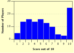
Score Distribution

quiz
Quiz Answer Key and Fun Facts
1. Nathaniel Bowditch wrote this authoritative text on marine navigation in 1802, and it's still in use today. What is it?

Answer: American Practical Navigator

Bowditch taught himself calculus at the age of 14. His seagoing career ended by his 30th year, and he devoted himself thereafter to study, teaching and insurance actuarial work.
2. Cartographer Gerardus ________ first used the term "atlas" for a book of maps, and developed an accurate way to show the surface of a sphere on a flat, rectangular map with the least distortion.

Answer: Mercator

Mercator's projection has the most distortion toward the poles, causing land areas in the upper latitudes to appear much larger than they actually are.
3. Aboard U.S. Navy ships, enlisted navigation specialists are known as ________ .

Answer: Quartermasters

Quartermasters in the Army have quite a different job - supply!
4. A navigation device used to plot horizontal sextant angles on a chart to obtain a "fix" of the ship's location is a _____.

Answer: three-arm protractor

The three-arm protractor is a beautiful, precision instrument with two moveable arms and one fixed arm that are set to the angles observed between three terrestrial objects. When the arms are then placed so that they bisect the objects, the position of the observer is at the center of the protractor.
5. Large-area rotating ocean currents that are caused by prevailing winds and the Coriolis Effect are _____.

Answer: gyres

The center of a gyre is an area of high atmospheric pressure, which spins clockwise in the Northern Hemisphere. The mighty Gulf Stream is the western boundary of the North Atlantic Gyre.
6. The determination of _____ at sea couldn't be readily determined until an accurate timepiece, the marine chronometer, was developed.

Answer: longitude

Englishman John Harrison is credited with building the first reliable marine chronometer in 1773.
7. Although a _____ route follows the shortest distance between points on the globe, it is difficult to steer so ships usually break the route into a series of straight rhumb line sections.

Answer: Great circle

Ships sailing from Los Angeles to Japan follow a great circle route that takes them as far north as the Aleutian Islands, but is many hundreds of miles shorter than a straight (rhumb line) route.
8. A _____ is a simple hand-held device used to estimate the observer's distance from an object of known height; this instrument was also used in submarine periscopes.

Answer: stadimeter

The stadimeter was developed in the 1890s for use in naval gunnery and navigation, and is still used today when radar is inappropriate, such as when two ships are very close together conducting underway replenishment.
9. A map of the sea bed and shoreline, used for marine navigation, is known as a _____.

Answer: nautical chart

A "map" is for looking at; a "chart" is for working on. Nautical charts can be traditional paper or modern electronic versions.
10. Nautical charts that show the most detail of a small area, such as a port or internal waterway, are ____ scale charts.

Answer: large

"Scale" is represented by a ratio such as 1:2500, meaning one unit of measure on the chart equals 2500 of those measures in the real world (i.e., 1 inch on the chart equals 2500 inches, or over 200 feet, on the surface of the earth). The larger the number indicating the proportion (to the right of the colon), the smaller the scale. Small-scale charts show large areas; large-scale charts show small areas.
Source: Author wjames

This quiz was reviewed by FunTrivia editor CellarDoor before going online.
Any errors found in FunTrivia content are routinely corrected through our feedback system.
4/23/2024, Copyright 2024 FunTrivia, Inc. - Report an Error / Contact Us