FREE! Click here to Join FunTrivia. Thousands of games, quizzes, and lots more!
Honduras Quizzes, Trivia and Puzzles
Honduras Quizzes, Trivia

Honduras Trivia

Honduras Trivia Quizzes

  1. Home
  2. »
  3. Quizzes
  4. »
  5. Geography Trivia
  6. »
  7. Central America

Fun Trivia
5 Honduras quizzes and 50 Honduras trivia questions.
1.
Honduras  The Tibet of Central America
  Honduras - The Tibet of Central America   top quiz  
Photo Quiz
 10 Qns
Home to nine of the 25 highest mountains in Central America, Honduras has aptly earned the moniker "The Tibet of Central America". Let's explore and uncover the beauty and wonders of this mountainous nation. Enjoy!
Easier, 10 Qns, Matthew_07, Aug 30 23
Easier
Matthew_07 gold member
Aug 30 23
189 plays
2.
  Honduras: "Free, Sovereign and Independent"   best quiz  
Multiple Choice
 10 Qns
Its national flower is an orchid, its national bird is the Scarlet Macaw - how much more exotic can a country get?
Average, 10 Qns, looney_tunes, Dec 19 12
Average
looney_tunes editor
4138 plays
3.
  Hola, Honduras   popular trivia quiz  
Multiple Choice
 10 Qns
Come, lets go to Central American and learn some of the history of Honduras. Off we go!
Average, 10 Qns, habitsowner, Jun 25 23
Average
habitsowner
Jun 25 23
2528 plays
4.
  Let's Go! Honduras    
Multiple Choice
 10 Qns
This is my eleventh 'Let's Go!' quiz, and this is on the interesting nation of Honduras. Enjoy.
Average, 10 Qns, Flynn_17, Dec 28 20
Average
Flynn_17
Dec 28 20
2147 plays
5.
  All about Honduras    
Multiple Choice
 10 Qns
Honduras means "great depths" in Spanish, named for its deep coastal waters. How much do you know about this nation?
Average, 10 Qns, LuH77, Jul 27 21
Recommended for grades: 12
Average
LuH77
Jul 27 21
171 plays
trivia question Quick Question
The Immaculate Conception Cathedral is one of the oldest cathedrals of Central America. What city of Honduras is it located in?

From Quiz "All about Honduras"


Honduras Trivia Questions

1. The Immaculate Conception Cathedral is one of the oldest cathedrals of Central America. What city of Honduras is it located in?

From Quiz
All about Honduras

Answer: Comayagua

Comayagua is a city located around 50 miles north-west of the capital, Tegucigalpa. Comayagua is the capital city of the Comayagua Department, one of Honduras' 18 Departments. The Immaculate Conception Cathedral is dedicated to Christ's mother, the Virgin Mary. It has a striking Baroque and Renaissance kind of architecture. Within this cathedral is a clock purported to be the oldest clock in the Americas. It was built by the Arabs around 1100 during the Middle Ages, when they were occupying Spain.

2. The Gulf of Fonseca borders Honduras to the south. What body of water borders the nation to the north?

From Quiz Hola, Honduras

Answer: Gulf of Honduras

The marine borders of Honduras are the Gulf of Fonseca which is a part of the Pacific Ocean, and the Gulf of Honduras, a part of the Caribbean Sea. It is also bordered by the countries of El Salvador, Nicaragua and Guatemala. Of those countries, Honduras comes in second in size at approximately 43,200 square miles, with Guatemala closely following with 42,000 square miles. Nicaragua has almost 50,000 square miles and little El Salvador has only a bit over 8,000 square miles. Honduras is slightly larger than the state of Tennessee.

3. Honduras has coastlines on both the Atlantic and the Pacific oceans. Which of the Honduran settlements is furthest away from the Pacific coastline of Honduras?

From Quiz Let's Go! Honduras

Answer: Tela

Tela is a settlement on the Atlantic sea-board, near to les Islans de la Bahia, a small set of islands off of the Honduran coast, in the Caribbean sea.

4. The Mico Quemado mountains are one of the main tourist attractions of what Honduran city?

From Quiz All about Honduras

Answer: El Progreso

The Mico Quemado (which translates as "burnt monkey") mountains are situated east of El Progreso. The mountain faces the valley of Sula. Much of this mountain range is protected by the Honduran government, partly due to the wealth of exotic plants and animals found there, partly because El Progreso's water source originates in these mountains. El Progreso is located in the Yoro Department of Honduras. It is a fertile city known for its agricultural prowess, featuring plantations of bananas, palm oil and vegetables.

5. What is the name of the largest lake in Honduras?

From Quiz Let's Go! Honduras

Answer: Lago de Yojoa

The area of Lago de Yojoa is 200 sq km., and it is located close to the large settlement of Comoyagua.

6. Which city of Honduras holds a festival every May to commemorate Saint Isidore the Laborer?

From Quiz All about Honduras

Answer: La Ceiba

Isidore the Laborer is the patron saint of La Ceiba, as well as a patron saint of farmers. 500,000 tourists are usually around Le Ceiba at the time of his festival. La Ceiba is a port city located on the northern coast of Honduras. It has officially been proclaimed as both the "Eco-Tourism Capital of Honduras" and the "Entertainment Capital of Honduras."

7. Which hurricane devastated Honduras in 1998, killing almost 5,600 people?

From Quiz Let's Go! Honduras

Answer: Hurricane Mitch

Hurricane Mitch caused close to four billion dollars worth of damage. Homes, factories and farms were all devastated by Hurricane Mitch. To add insult to injury, illnesses such as malaria then posed a greater threat as sanitation facilities were damaged by the hurricane.

8. Which airport of Honduras was ranked by the History Channel as the second-most dangerous airport in the world?

From Quiz All about Honduras

Answer: Toncontín International Airport

Due to its mountainous location and short runway, Toncontín International Airport has been rated among the most dangerous airports in the world. There have been several incidents of aircraft running out of runway and crashing - with fatalities. Fortunately, Honduras has other airports with much safer settings. Toncontín International Airport is located about four miles from one of the two capitals of Honduras, Tegucigalpa. During the Football War of 1969 Toncontín International Airport was a major target of the Salvadoran Air Force, who bombed it many times.

9. One area of Honduras in virtually uninhabited, with the only large settlement in this area being the port of Puerto Lempira. What is the name given to this area of eastern Honduras?

From Quiz Let's Go! Honduras

Answer: mosquito coast & la mosquitia

Puerto Lempira is one of the larger ports/harbours in Honduras, where much of the exportation to the U.S and Guatemala takes place. Most exportation to El Salvador is done via road or by the port of San Lorenzo.

10. When did Honduras declare itself independent of Spain?

From Quiz Hola, Honduras

Answer: 1821

Honduras became independent from Spain in 1821 but then joined The First Mexican Empire followed by the United Provinces of Central America. It wasn't until 1838 that it became a united, independent, republic and began holding elections. However, the years since becoming a republic have been fraught with almost 300 civil wars and rebellions, including a war with El Salvador called The Football War.

11. Honduras has three distinct topological regions - two narrow coastal strips, and an interior mountainous region. Approximately what percentage of the country's area is in the central mountains?

From Quiz Honduras: "Free, Sovereign and Independent"

Answer: 80%

The larger Caribbean lowlands in the north and the smaller Pacific lowlands bordering the Gulf of Fonseca (a strip averaging 25 km or 16 mi in width) are characterized by alluvial plains. The central highlands which form the majority of the country are mostly mountains, but there is a major depression that runs from the Caribbean (near San Pedro Sula) to the Gulf of Fonseca near the border with El Salvador. This depression, which facilitates transport of goods and people across the isthmus, splits the country into two parts, with the smaller western range being approximately a fifth of the total area.

12. At 2,870m tall, this mountain is the highest point in Honduras. What is the name of this mountain?

From Quiz Let's Go! Honduras

Answer: Cerro Las Minas

Cerro Las Minas is located near to the larger settlement of Santa Rosa de Copán, and is close to the borders that Honduras shares with it neighbours, El Salvador and Guatemala.

13. What city of Honduras had the dubious title of "murder capital of the world" until Caracas, Venezuela, surpassed it in 2016?

From Quiz All about Honduras

Answer: San Pedro Sula

San Pedro Sula is a city located in the north of Honduras. Honduras may be one of the most dangerous and violent countries in the world, but this is concentrated in certain areas of the country. Figures from 2015 state that the cities of Tegucigalpa, San Pedro Sula and La Ceiba hosted around 40% of the countries homicides that year. Since the Honduran military coup of 2009, the city of San Pedro Sula has suffered from both unemployment and poverty. The presence of the criminal gangs Mara Salvatrucha (MS-13) and Barrio 18, is very apparent in San Pedro Sula.

14. In La Mosquitia, along the Platano River, an area was named a World Heritage Site was in 1982. What is this site called?

From Quiz Hola, Honduras

Answer: Rio Platano Biosphere Reserve

The Rio Platano Biosphere Reserve began life as "The Ciudad Blanca Archaeological Reserve", named after the legendary White City that is alleged to be in the area, but took its present name in 1980. A plan to develop and manage the area was formulated in 1980 but wasn't implemented until 1987. In addition to many species of fauna, many of whom are on the endangered list, there are over 200 archaeological sites, including the spot where Columbus landed in 1502. In 1996 is was listed as a World Heritage in Danger, but by 2007 it was removed from that list due to conservation improvements. Unfortunately, by 2011 those original efforts seemed not to have been followed up. UNESCO has found slash and burn clearing, logging of the mahogany trees and illegal hunting and fishing in the main area of the Biosphere. Since the Reserve has one of the few undisturbed tropical rain forests in all of Central America, as well as part of the largest in Honduras, it has rare and endangered animals, including the giant anteater and jaguar. So far they have documented 39 species of mammals, 377 species of birds, and 126 species of reptiles and amphibians. It also has over 2,000 plants, many of which are new to science and there may be more that are yet to be discovered. Eco-tourism is gearing up in the region but the Honduran government has no plan for its development and so far it has caused damage to some archaeological sites. Refugees from both Honduras and other countries are moving in and compounding problems for the proper management of the reserve.

15. What is the largest department of the 18 departments of Honduras by area?

From Quiz All about Honduras

Answer: Olancho

The Olancho department covers approximately 9,300 square miles. Its capital city is Juticalpa. In around 1864 the Olancho War happened. About 1,000 rebels, under the leadership of a man named Rosales, revolted against the department's government the following year in 1865. The military got involved on the orders of the then President of Honduras, José María Medina. Towns of Olancho were burned. Leaders of the rebels were captured, shot, beheaded and buried. The dangerous conditions of living here resulted in a mass exodus from Olancho during this period.

16. The monetary unit of Honduras is named after a certain chief of an indigenous tribe. What currency does Honduras use?

From Quiz Hola, Honduras

Answer: lempira

The lempira is divided into 100 centavos, just as a dollar is divided into 100 cents. It is named after Lempira, the war chief (cacique) of the Lenca tribe in the 1530s who unified the various tribes which were then strong enough to resist the conquistadors, at least until he was killed in 1537 and his troops ran away. He is a national hero for his attempt to keep the western tribes independent of Spain. The lempira as currency replaced the peso in 1931 and the first notes were used in 1932.

17. Every country has a literacy rate, which means the percentage of people within the country, of each gender, who have the ability to read and write. In 2004, what was unusual about the literacy rates in Honduras?

From Quiz Let's Go! Honduras

Answer: The female literacy rate was higher than the male

In most developing countries, the male literacy rate is higher than the female literacy rate, such as in El Salvador, where 82.8% of all males can read and write, and only 77.7% of all females can (2004 figures). In Honduras, in 2004 76.1% of all males could read and write whereas 76.3% of all females were literate.

18. The flag of Honduras has the same colors as do the flags of Greece and Finland. However, rather than having a cross, the Honduran flag has other symbols. Tell me what they are?

From Quiz Hola, Honduras

Answer: 5 stars

The Honduran flag is made up of three bands, the top and bottom blue stripes represent the Pacific, the Caribbean, and blue sky, as well as brotherhood. The middle white band represents the land between the waters and peace, prosperity and purity of thought. Additionally, there are five stars, each with five points, placed in an "X" pattern on the white background. These stars represent the nations of the former Federal Republic of Central America, with the hope that it will form again. The flag was adopted March, 1886.

19. Lempira is a port on the Atlantic seaboard, and also a 'departamentos', or county, of Honduras. What other relevance does the name 'Lempira' have to Honduras?

From Quiz Let's Go! Honduras

Answer: The Lempira is the currency of Honduras

Puerto Lempira is one of the most important ports on the Atlantic coast, as it is the only large settlement on the Mosquito Coast. The other 17 'departamentos', or counties, are: Atlantida, Choluteca, Colon, Comayagua, Copan, Cortes, El Paraiso, Francisco Morazan, Gracias a Dios, Intibuca, Islas de la Bahia, La Paz, Ocotepeque, Olancho, Santa Barbara, Valle, and Yoro.

20. The Bay Islands are a cluster of islands owned by and off the coast of Honduras, collectively forming one of Honduras' 18 departments. What is the capital city of this department?

From Quiz All about Honduras

Answer: Coxen Hole

Coxen Hole is located on the island of Roatán. It is named after the pirate John Coxon, who used the island as a safe haven, as well as thousands of other pirates. It is argued that perhaps the islanders misspelled his surname. Coxen Hole was established around 1835. Several British families had re-located to Roatán from the Cayman Islands (in the west of the Caribbean Sea).

21. Where would you find bottlenose dolphins in Honduras?

From Quiz Hola, Honduras

Answer: Islas de la Bahia

The Islas de la Bahia (Bay Islands) is a group of eight islands and over fifty cays lying off the northern coast of the country and have been a part of Honduras since 1872. Most of the islands, large or small, are of rugged terrain. Roatan is the largest island of the group, where there is a commercial business where you can swim with the dolphins. Both tourism and fishing are the economic pillars of the Islands, although the fishing is limited now due to prior over-fishing. Scuba diving and snorkeling are popular, and one can view manta rays, whale sharks, crabs, lobster, and various other sea life. There are plenty of dive shops available to help you.

22. On what date did Honduras become independent from Spain?

From Quiz Let's Go! Honduras

Answer: September 15, 1821

Although Spain were the first settlers in Honduras, the Spanish Europeans are now only 1% of the population. The majority of the population are now the 'Mestizo', an Amerindian race, with dual Amerindian and European heritage.

23. Cerro El Pital is a mountain located on the border of Honduras and what other country?

From Quiz All about Honduras

Answer: El Salvador

Cerro El Pital is around 8,960 feet high. It is the highest point in El Salvador, and the third highest point in Honduras. The highest mountain of Honduras is Cerro Las Minas. Cerro El Pital is covered by a cloud forest, which is a forest featuring persistent low-level cloud cover, normally at the canopy level. This forest is home to some rare animals and planets including quetzals, which are brightly coloured birds.

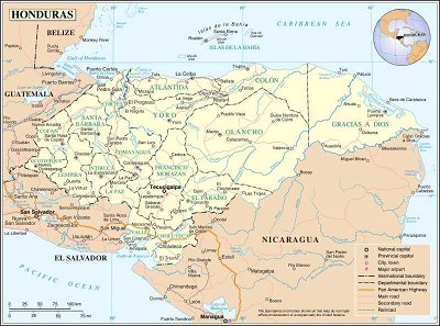
24. Honduras contains one of the richest archaeological sites in the Americas in the ruins of the city of Copan. What ancient civilization built this beautiful and important site?

From Quiz Hola, Honduras

Answer: Mayan

Copan is in the western corner of the country, near to Guatemala. It is believed that by 200 AD a community had formed in the Copan valley but the people were not as advanced as were the Mayans. In 426, a prince arrived from Mexico, took control of the city, and founded a Mayan dynasty. By the 800s a great town of 20,000 people with large, magnificent, ceremonial buildings, temples and works of art stood in the Copan valley. These people were successful in architecture, mathematics, astronomy and sculpture, but they didn't do as well in the use and conservation of their land, keeping the peace, or keeping their people healthy. The problem of feeding their growing population became worse and they used more slash and burn methods to try to grow more food, depleting the nutrients in the land. In the meantime, the elite of the town were building their houses on the river banks, the logical place to plant harvestable crops. Scientists have shown that the people were malnourished and sickly, as well as dying younger than had earlier generations, probably from their lack of growing enough food. To add to their problems, unlike other societies such as the Incans, they did not form a union or confederacy but remained independent city-states. As such, they warred with other Mayan cities, trying to conquer and control one another. Finally, a neighboring city that had been under Copan's control for too long rose up and killed Copan's head man, causing Copan to slowly begin to decline. The city died out and was covered by the jungle. Copan was found again in 1576 by a Spanish explorer and again in 1834 a general in the Honduran army, but neither of them could get any support from their people for further exploration of the site. However, an American diplomat's interest was piqued and in 1838 he spent a few weeks in Copan, eventually buying it from the farmer who owned the land for $50. After that, the explorations began in earnest and are still going on today. In 1980 it was named a UNESCO World Heritage Site.
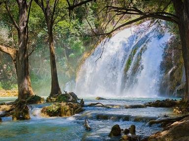
This is category 20422
Last Updated Mar 23 2024 5:49 AM
play trivia = Top 5% Rated Quiz, take trivia quiz Top 10% Rated Quiz, test trivia quiz Top 20% Rated Quiz, popular trivia A Well Rated Quiz
new quizzes = added recently, editor pick = Editor's Pick editor = FunTrivia Editor gold = Gold Member

Teachers / educators: FunTrivia welcomes the use of our website and quizzes in the classroom as a teaching aid or for preparing and testing students. See our education section. Our quizzes are printable and may be used as question sheets by k-12 teachers, parents, and home schoolers.

 ·  All questions, answers, and quiz content on this website is copyright FunTrivia, Inc and may not be reproduced without permission. Any images from TV shows and movies are copyright their studios, and are being used under "fair use" for commentary and education.