FREE! Click here to Join FunTrivia. Thousands of games, quizzes, and lots more!
Zimbabwe Quizzes, Trivia and Puzzles
Zimbabwe Quizzes, Trivia

Zimbabwe Trivia

Zimbabwe Trivia Quizzes

  1. Home
  2. »
  3. Quizzes
  4. »
  5. Geography Trivia
  6. »
  7. Africa

Fun Trivia
3 Zimbabwe quizzes and 35 Zimbabwe trivia questions.
1.
Zimbabwe  The Jewel of Africa
  Zimbabwe - The Jewel of Africa   top quiz  
Photo Quiz
 10 Qns
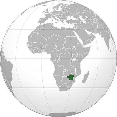
Owing to its strong economy in the 1980s, Zimbabwe was once dubbed "The Jewel of Africa". What else do you know about this nation that is best remembered as the country that appears last in the alphabetical list of all nations? Let's find out!
Easier, 10 Qns, Matthew_07, Mar 20 22
Easier
Matthew_07 gold member
Mar 20 22
850 plays
2.
  A Provincial Tour of Zimbabwe   best quiz  
Multiple Choice
 10 Qns
Zimbabwe is divided into 8 provinces and 2 cities with provincial status for administrative purposes. Check out the interesting features of these areas.
Average, 10 Qns, looney_tunes, Feb 19 18
Average
looney_tunes editor
Feb 19 18
4456 plays
3.
  Zimbabwean Geography    
Multiple Choice
 15 Qns
This quiz covers various geographical facts about the African nation Zimbabwe.
Tough, 15 Qns, Trooper_nut, Feb 23 23
Tough
Trooper_nut
Feb 23 23
2350 plays

Zimbabwe Trivia Questions

1. Matabeleland North is the site of Victoria Falls, one of the world's largest waterfalls, located on the Zambezi River. They are located on the border with which of Zimbabwe's neighbours?

From Quiz
A Provincial Tour of Zimbabwe

Answer: Zambia

The Victoria Falls, called in the Lozi language Mosi-oa-Tunya (the Smoke that Thunders), are on the Zambezi River, on the border between Zimbabwe and Zambia. The fall is a distance of 108 m (360 ft), with an average flow rate of 1,088 cu m/s (38,430 cu ft/s). Victoria Falls National Park (along with Zimbabwe National Park, adjacent to the west along the river) features an abundance of wildlife: elephant, buffalo, giraffe, zebra, antelopes, vervet monkeys and baboons are common; lions and leopards are occasionally seen. Above the falls, the river has large populations of hippopotamus and crocodile. A large variety of birds are also found near the falls, including several species which breed there. The names of many of Zimbabwe's provinces are based on the historical development of the country. The Matabeleland districts were conquered by settlers during the First Matabele War (1893-1894), and were the tribal lands of the Ndebele people.

2. The ancient ruins of Great Zimbabwe are found about 29km from what major Zimbabwean City?

From Quiz Zimbabwean Geography

Answer: Masvingo

The ruins of Great Zimbabwe are found near the city of Masvingo. Masvingo's name is actually pronounced "Mashingo" and it is easy to recognize foreigners when they emphasize the "v" by mistake!

3. The city-province of Bulawayo lies between Matabeleland North and Matabeleland South, near the watershed between the drainage of the Zambezi and that of Zimbabwe's other major river. Which river is that?

From Quiz A Provincial Tour of Zimbabwe

Answer: Limpopo

Bulawayo is the second largest city in Zimbabwe, after the capital Harare, with a population in 2009 of 1,500,000. Before becoming an administrative area in its own right, it was the capital of Matabeleland North. Located on Zimbabwe's Highveld (High Plain), it is close to the watershed between the Zambezi River, which forms part of Zimbabwe's northern border with Zambia, and the Limpopo River, which forms part of the southern border with South Africa. Bulawayo is home to the Queens Sports Club and Bulawayo Athletic Club, two of the three grounds in Zimbabwe where Test match cricket has been played. It is also an important venue for Rugby matches.

4. What large man-made lake is also near the ruins of Great Zimbabwe?

From Quiz Zimbabwean Geography

Answer: Lake Kyle

The wildlife preserve surrounding Lake Kyle is known for large (relatively) numbers of the highly endangered white rhinos. White rhinos are often killed for their horns.

5. Matabeleland South is one of Zimbabwe's driest provinces, situated as it is on the edge of a desert. What desert is located just to the southwest of Zimbabwe?

From Quiz A Provincial Tour of Zimbabwe

Answer: Kalahari desert

The Kalahari desert covers most of Botswana, as well as large portions of Namibia and South Africa and small areas of Angola, Zambia and Zimbabwe. It is actually only a semi-desert region, and supports wildlife with large areas of excellent grazing after good rainfalls. There are a number of nature reserves featuring such spectacular wildlife as hyenas, lions, meerkats, giraffes, warthogs, and a range of antelope species. There are even seasonal wetlands in the desert, which attract flamingos during the rainy season.

6. Beitbridge, on Zimbabwe's southern border, crosses what major river?

From Quiz Zimbabwean Geography

Answer: Limpopo River

Bietbridge crosses the "great green greasy Limpopo" on the way to South Africa. It is a major "port of entry" into Zimbabwe.

7. Zimbabwe gets its name from the ruins of an ancient city in Masvingo province, the Great Zimbabwe National Monument. What does the name Zimbabwe mean in the Karanga dialect of the Shona language?

From Quiz A Provincial Tour of Zimbabwe

Answer: Large houses of stone

The term 'zimbabwe' is used to describe over 200 sites in southern Africa with the ruins of large buildings constructed with mortarless walls, of which the Great Zimbabwe is the largest, having been the capital of the Kingdom of Zimbabwe (1220-1450). The kingdom of Zimbabwe controlled the ivory and gold trade from the interior of Africa to the coast, and was also a centre for imports from Arabia and Asia. The most commonly accepted origin for the word 'zimbabwe' is that it is derived from 'dzimba-dza-mabwe', and means 'large houses of stone'. It may also be a contracted form of 'dzimba woye' which means 'venerated houses' in the Zezuru dialect.

8. This national park, covering 14,600 square kilometers, is Zimbabwe's largest. Some of its most important camps include: Main Camp, Robins Camp, Nantwitch Camp, and Sinamatella Camp. Name this park.

From Quiz Zimbabwean Geography

Answer: Hwange National Park

Hwange is Zimbabwe's largest national park. It has a great variety of wildlife, and is known especially for its lions. The park's close proximity to Victoria Falls makes it an important tourist attraction.

9. One of the largest waterfalls in the world, this waterfall lies on the Zambezi River, and was discovered by Dr. David Livingstone.

From Quiz Zimbabwean Geography

Answer: Victoria Falls & Vic Falls & Victoria

Victoria Falls is also known as "the smoke that thunders," a name that refers to its large roar and the mist cloud that it produces which can be seen from miles away. The Falls itself actually consists of five smaller segments.

10. A large number of balancing rocks can be found outside of what major Zimbabwean city? (Hint: also the country's capital)

From Quiz Zimbabwean Geography

Answer: Harare

The large granite "sculptures" slowly formed as nature wore down large stacks of granite boulders. There are several different stacks of these balancing rocks just outside of Harare.

11. This large national park in southeast Zimbabwe was named for the large number of elephants that can be found there.

From Quiz Zimbabwean Geography

Answer: Gonarezhou National Park

The word Gonarezhou actually means "place of elephants." While Gonarezhou was supposedly named after its bountiful elephants, every time we go, we never can find many at all. Oh well.

12. The _________ Highlands are lush, forested mountains where coffee, tea, and lumber are produced.

From Quiz Zimbabwean Geography

Answer: Eastern & East

The Eastern Highlands is a very beautiful area. It is rather rough terrain, and is on the Zimbabwean border with Mozambique. Some of the best coffees in the world are grown here.

13. At 2592m. this mountain is the tallest in Zimbabwe.

From Quiz Zimbabwean Geography

Answer: Mount Nyangani

Mount Nyangani is found in the northern part of the Eastern Highlands and is a popular destination for hikers and amateur climbers.

14. The highest point in Zimbabwe is found in the province of Manicaland. What is its name?

From Quiz A Provincial Tour of Zimbabwe

Answer: Mount Nyangani

Mount Nyangani, formerly known as Mount Inyangani, is 2,592 m (8,504 ft) above sea level at its peak. It is in the Nyanga National Park, about 275 km (170 mi) southeast of Harare, near the border with Mozambique. Manicaland is also the location of Murahwa Hill, known for its rock paintings and Iron Age village. Mount Smith is in Ethiopia, while Mount Kilimanjaro and Mount Meru are both in Tanzania.

15. This fish is a popular gamefish in the Highlands, especially in the Nyanga area.

From Quiz Zimbabwean Geography

Answer: Trout

Trout fishing is very common in the Eastern Highlands. It is a popular tourist activity and one of the luxury hotels in the area is even named "Troutbeck."

16. This large lake was created on the Zambezi River in the 1950s by the British government to generate electricity for Zambia & Zimbabwe.

From Quiz Zimbabwean Geography

Answer: Lake Kariba

The Kariba dam took almost ten years to complete. It dramatically changes the landscape of northwestern Zimbabwe and the lives of the people that lived there. Today, the area is a main tourist attraction, and is very economically important to the country.

17. Found near Kariba Road this large cave system, known for its Sleeping Pool, is a beautiful attraction near Chinhoyi.

From Quiz Zimbabwean Geography

Answer: Chinhoyi Caves

These caves were named after Chief Chinhoyi who, in 1830, brought his people to the refuge of the caves to avoid the attack of a hostile tribe. Instead, unable to escape their enemies, Chief Chinhoyi and his people were thrown to into the Sleeping Pool to their deaths.

18. What is the beautiful resort hotel, found east of Mutare, that resembles a Scottish moorland castle? It is also known for its golf course and its casino.

From Quiz Zimbabwean Geography

Answer: Leopard Rock

This hotel was a favorite of Queen Elizabeth, who stayed there in 1953. It was extensively damaged by rocket fire during the Bush War, but was restored later by a wealthy tobacco farmer.

19. This bridge over the Save River was, at one time, the second largest suspension bridge in the world. It is very similar in appearance to Australia's Sydney harbor bridge.

From Quiz Zimbabwean Geography

Answer: Birchenough Bridge

This bridge was built by the British in the 1930's. Its picture can also be found on the Zimbabwe twenty cent coin.

This is category 20363
Last Updated Mar 23 2024 5:49 AM
play trivia = Top 5% Rated Quiz, take trivia quiz Top 10% Rated Quiz, test trivia quiz Top 20% Rated Quiz, popular trivia A Well Rated Quiz
new quizzes = added recently, editor pick = Editor's Pick editor = FunTrivia Editor gold = Gold Member

Teachers / educators: FunTrivia welcomes the use of our website and quizzes in the classroom as a teaching aid or for preparing and testing students. See our education section. Our quizzes are printable and may be used as question sheets by k-12 teachers, parents, and home schoolers.

 ·  All questions, answers, and quiz content on this website is copyright FunTrivia, Inc and may not be reproduced without permission. Any images from TV shows and movies are copyright their studios, and are being used under "fair use" for commentary and education.