FREE! Click here to Join FunTrivia. Thousands of games, quizzes, and lots more!
Quiz about The Rooftop of the World

The Rooftop of the World Trivia Quiz


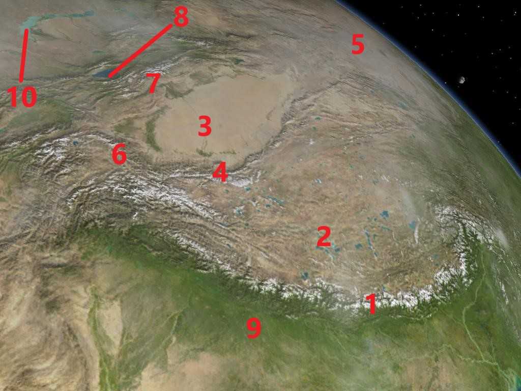
Central Asia has long been known as the 'rooftop of the world'. With its towering mountains and immense beauty, I can't dispute this. Test your knowledge of this area and the geographical features in it.

A label quiz by LeoDaVinci. Estimated time: 3 mins.
  1. Home
  2. »
  3. Quizzes
  4. »
  5. Geography Trivia
  6. »
  7. Asia

Author
LeoDaVinci
Time
3 mins
Type
Label Quiz
Quiz #
415,590
Updated
Feb 24 24
# Qns
10
Difficulty
Tough
Avg Score
5 / 10
Plays
122
Awards
Top 5% quiz!
Last 3 plays: DeepHistory (10/10), Guest 71 (10/10), jh334 (10/10).
Pick the geographical feature represented by the red numbers.
Gobi Desert Himalayan Mountains Tibetan Plateau Kunlun Mountains Indus-Ganga Plain Tian Shan Taklamakan Desert Pamir Mountains Issyk Kul Lake Balkhash
* Drag / drop or click on the choices above to move them to the answer list.
1.   
2.   
3.   
4.   
5.   
6.   
7.   
8.   
9.   
10.   

Most Recent Scores
Apr 21 2024 : DeepHistory: 10/10
Apr 16 2024 : Guest 71: 10/10
Apr 15 2024 : jh334: 10/10
Apr 09 2024 : Guest 73: 5/10
Apr 06 2024 : MikeyGee: 10/10
Apr 03 2024 : miamisammy29: 4/10
Mar 31 2024 : bdayboiii: 7/10
Mar 30 2024 : PurpleComet: 10/10
Mar 30 2024 : james1947: 10/10

Quiz Answer Key and Fun Facts
1. Himalayan Mountains

The Himalayas are a vast mountain range in Asia, stretching across five countries: India, Nepal, Bhutan, China (Tibet), and Pakistan. They extend over 2400 kilometers from west to east while spanning the entire northern boundary of the Indian subcontinent. In fact, it's the tectonic plate that is carrying the Indian subcontinent northwards into the Eurasian plate that has caused the Himalayas to be so tall, a process that is still ongoing.

The Himalayas are home to the world's highest peaks, including Mount Everest, which is the tallest mountain on Earth, standing at 8,848 meters above sea level. Other notable peaks in the Himalayas include K2, Kangchenjunga, Lhotse, and Makalu.

The Himalayas have long been revered by the people of South Asia and Tibet, and they are deeply ingrained in the religious and cultural traditions of the region. The mountains are home to numerous sacred sites, temples, and monasteries, and they have inspired countless myths, legends, and spiritual practices.
2. Tibetan Plateau

The Tibetan Plateau is a vast elevated plateau in Central Asia. It is located in the heart of Asia, which spans over several countries but the majority of it is in China. At an average of 4500 meters in elevation and covering an area of approximately 2.5 million square kilometers, this makes it the largest and highest plateau in the world. It is bordered by some of the world's highest mountain ranges, including the Himalayas to the south, the Kunlun Mountains to the north, and the Karakoram Range to the west. Additionally, it is the traditional homeland of the Tibetan people and the center of Tibetan Buddhism, with numerous monasteries, temples, and sacred sites scattered across the plateau.

The Tibetan Plateau has a unique climate characterized by its high elevation and cold temperatures. Winters are long and harsh, with temperatures dropping well below freezing, while summers are relatively short and cool. Precipitation varies across the plateau, with some areas receiving significant rainfall while others are much drier. Some of the world's most unique and interesting species come from here; it is home to a variety of wildlife, including species such as the Tibetan antelope, snow leopard, Tibetan wolf, and various species of birds and plants.

The Tibetan Plateau is often referred to as the "Water Tower of Asia" because it is the source of many of Asia's major rivers, including the Indus, Ganges, Brahmaputra, Yangtze, Yellow, and Mekong rivers. These rivers provide water for millions of people downstream and support agriculture, industry, and ecosystems across the region.
3. Taklamakan Desert

The Taklamakan Desert is one of the largest and driest deserts in the world, located in the Tarim Basin in the Xinjiang Uygur Autonomous Region of northwest China. It covers an area of approximately 337,000 square kilometers, just smaller than the country of Germany. It is situated between the Kunlun Mountains to the south and the Tian Shan to the north, with the Tarim River running through its center.

The Taklamakan Desert has an extreme continental climate, characterized by hot summers and cold winters. Summer temperatures can exceed 40° C, while winter temperatures can drop below freezing. The desert receives very little precipitation, with annual rainfall averaging less than 50 millimeters in most areas.

The landscape of the Taklamakan Desert is dominated by vast stretches of sand dunes, some of which can reach heights of over 200 meters. These dunes are constantly shifting due to wind erosion and deposition, creating a dynamic and ever-changing environment. Despite this, it is not entirely devoid of vegetation. Apart from hardy desert plants, there are many oases where a variety of plants do thrive.

The Taklamakan Desert has a long history of human habitation, with evidence of ancient settlements dating back thousands of years. The desert was once an important crossroads on the ancient Silk Road, once linking China with Central Asia and the Middle East. Numerous archaeological sites have been discovered in the desert, including the famous Silk Road oasis towns of Loulan and Niya.
4. Kunlun Mountains

The Kunlun Mountains are a major mountain range in Asia, extending for about 3,000 kilometers from the the Hexi Corridor in the east to the Pamir Plateau in the west. In the east, they connect to the Qinling Mountains. These mountains are mostly in the Chinese provinces of Xinjiang, Qinghai, and Tibet.

The terrain in the Kunlun Mountains is pretty rugged, with deep valleys and treacherous glaciers that can open up to reveal dangerous crevasses. These glaciers play a crucial role in regulating water flow and supporting ecosystems downstream in the rivers that run off of them.

The Kunlun Mountains have a rich cultural heritage and are steeped in mythology and folklore. In Chinese mythology, the Kunlun Mountains are believed to be the dwelling place of immortals and are often depicted as a mythical paradise. However, they are also rich in resources like precious metals and jade, meaning, they have an economic impact on the region.
5. Gobi Desert

The Gobi Desert is a gigantic desert region in northern China and southern Mongolia, covering an area of approximately 1.3 million square kilometers. It is bordered by the Altai Mountains and the Mongolian steppes to the north, the Tian Shan and the Taklamakan Desert to the west, and the North China Plain to the southeast.

The Gobi Desert has a continental climate, with hot summers and cold winters. Temperatures can vary greatly between day and night, with summer temperatures exceeding 40° C. On the other hand, winter temperatures can be extremely cold, with temperatures below -40° C as a regular occurrence.

Wildlife in the Gobi includes species such as the Bactrian camel, snow leopard, Gobi bear, and various species of gazelles, lizards, and birds. It has been traversed by nomadic tribes, traders, and explorers throughout history, and it was an important part of the ancient Silk Road trade route. Numerous archaeological sites and ancient petroglyphs can be found throughout the desert that show its rich history.
6. Pamir Mountains

The Pamir Mountains are a mountain range in Central Asia that extend across parts of Tajikistan, Kyrgyzstan, Afghanistan, Pakistan, and China. The Pamir Mountains are located at the junction of several major mountain ranges, including the Himalayas to the south, the Karakoram Range to the southeast, the Kunlun Mountains to the northeast, and the Hindu Kush to the west. This strategic location has earned the Pamirs the nickname "Roof of the World".

The Pamir Mountains are characterized by their rugged terrain, towering peaks, deep valleys, and numerous glaciers. Several of the highest peaks in Central Asia are located in the Pamirs, including Peak Lenin, rising up at 7134 meters, and Peak Communism towering at 7495 meters. This means that they are a popular destination for mountaineers, trekkers, and adventure travelers. People are naturally drawn to the region's stunning landscapes, remote villages, and challenging climbing routes. Luckily, tourism in the Pamirs is still relatively undeveloped compared to other mountain regions contributing to its wild and unspoiled character.

The Pamir Mountains are home to a diverse range of ethnic groups, including the Pamiris, Kyrgyz, Tajiks, and Wakhi people. These communities have maintained traditional ways of life for centuries, relying on pastoralism, agriculture, and trade for their livelihoods. This is one of the reasons why they have been an important crossroads for trade and cultural exchange for millennia. The ancient Silk Road passed through the region, not surprisingly.
7. Tian Shan

The Tian Shan, also historically spelled Tien Shan, is a large mountain range in Central Asia, spanning several countries including Kazakhstan, Kyrgyzstan, Uzbekistan, and China. It stretches for about 2800 kilometers from west to east, forming a natural border between the arid plains of Central Asia to the north and the Tarim Basin and Tibetan Plateau to the south.

The Tian Shan is characterized by its rugged terrain, towering peaks, deep valleys, and numerous alpine glaciers. Several of the highest peaks in Central Asia are located in the Tian Shan, including Jengish Chokusu (also known as Khan Tengri), which is the highest peak in Kazakhstan, and Peak Pobeda (also known as Victory Peak), the highest peak in Kyrgyzstan.

The Tian Shan has been inhabited by various nomadic and semi-nomadic tribes for thousands of years, and it has played a significant role in the cultural and historical development of Central Asia. The region has been a crossroads for trade and cultural exchange between East and West with ancient Silk Road routes passing through the many valleys.

One last note is that, due to climate change, the glaciers of the Tian Shan are experiencing significant retreat. While this is a worldwide problem, this still is concerning specifically for the Tian Shan.
8. Issyk Kul

Issyk Kul is a large, endorheic lake located in the northern part of Kyrgyzstan, in Central Asia. It is the second-largest alpine lake in the world, after Lake Titicaca in South America. It covers approximately 6236 square kilometers and it is located at an elevation of approximately 1607 meters above sea level. The maximum depth of Issyk Kul is around 668 meters, making it one of the deepest lakes in the world.

The name 'Issyk Kul' translates to 'Warm Lake' in the Kyrgyz language, although it does not freeze in winter due to its minor saline content, not its temperature. So, while Issyk Kul is a saline lake, its salinity is relatively low compared to other saline lakes. The salinity of Issyk Kul is about 0.6%, which is much lower than that of the oceans. This moderate salinity level contributes to the lake's ability to sustain a variety of aquatic life.

Issyk Kul is surrounded by the Tian Shan mountain range, which contributes to its stunning scenery. The lake is a popular tourist destination known for its beautiful beaches, clear waters, and opportunities for outdoor activities such as swimming, boating, and hiking. Additionally, the region around Issyk Kul has a rich cultural history with archaeological sites dating back thousands of years.
9. Indus-Ganga Plain

The Indus-Ganga Plain, also known as the Indo-Gangetic Plain, is a vast alluvial plain in South Asia. It stretches across the northern and eastern parts of the Indian subcontinent, covering large portions of India, Pakistan, Nepal, and Bangladesh. It is bounded by the Himalayas to the north and northwest, the Aravalli Range to the west, the Vindhya Range to the south, and the Brahmaputra River basin to the east. This plain is one of the most extensive and fertile plains in the world, covering an area of approximately 1.1 million square kilometers!

The plain is characterized by the presence of several major rivers, including the Indus, Ganges, Brahmaputra, Yamuna, and their tributaries. These rivers originate from the Himalayas and carry vast amounts of sediment. These mineral-rich deposits contribute to its fertility as does the abundance of water. It has historically been one of the most agriculturally productive regions in the world.

Unfortunately, the Indus-Ganga Plain is one of the most densely populated regions on Earth. Its population exceeded 500 million people in 2023. The availability of fertile land and water resources has historically attracted human settlement and facilitated the development of urban centers and civilizations.
10. Lake Balkhash

Lake Balkhash is one of the largest lakes in Central Asia and it is located in southeastern Kazakhstan. To the north of Lake Balkhash lies the vast Kazakh Steppe, a region characterized by grassland plains and semi-arid climate. To the south and southeast, the lake is bordered by the Tian Shan mountain range. The western shores of the lake are relatively flat, while the eastern shores are more rugged and mountainous.

The lake covers an area of approximately 16,400 square kilometers. Lake Balkhash supports a diverse ecosystem, including various species of fish, birds, and other wildlife. The lake is an important habitat for migratory birds and serves as a breeding ground for many species.

One of the most distinctive features of Lake Balkhash is its divided nature. The eastern part of the lake is significantly more saline than the western part due to differences in the sources of water inflow. The western part receives water primarily from the Ili River, which brings freshwater, while the eastern part receives water from smaller rivers and streams with higher saline content.

Lake Balkhash faces several environmental challenges, including water pollution, habitat degradation, and water diversion for agricultural and industrial purposes. Efforts are underway to address these issues and promote sustainable management of the lake's resources.
Source: Author LeoDaVinci

This quiz was reviewed by FunTrivia editor agony before going online.
Any errors found in FunTrivia content are routinely corrected through our feedback system.
4/27/2024, Copyright 2024 FunTrivia, Inc. - Report an Error / Contact Us