FREE! Click here to Join FunTrivia. Thousands of games, quizzes, and lots more!
Nauru Quizzes, Trivia and Puzzles
Nauru Quizzes, Trivia

Nauru Trivia

Nauru Trivia Quizzes

  1. Home
  2. »
  3. Quizzes
  4. »
  5. Geography Trivia
  6. »
  7. Pacific Islands

Fun Trivia
6 Nauru quizzes and 60 Nauru trivia questions.
1.
Nauru  Pleasant Island
  Nauru - Pleasant Island   great trivia quiz  
Photo Quiz
 10 Qns
One of the world's least visited countries, the Pacific island nation of Nauru was named "Pleasant Island" by British sea captain John Fearn when he first sighted the island in 1798. What else do you know about this lesser-known Oceanic microstate?
Easier, 10 Qns, Matthew_07, Mar 01 22
Recommended for grades: 9,10,11,12
Easier
Matthew_07 gold member
Mar 01 22
258 plays
2.
  Nice Little Nauru   top quiz  
Multiple Choice
 10 Qns
Nauru, the third-smallest country in the world. A tiny little speck in the middle of the Pacific Ocean. Not many secrets to this island - see what you know of this tropical nation.
Average, 10 Qns, LeoDaVinci, Mar 21 20
Average
LeoDaVinci editor
Mar 21 20
1262 plays
3.
  What? Where? Who? Nauru!    
Multiple Choice
 10 Qns
Let's take a quick tour of the remote Pacific island nation of Nauru.
Average, 10 Qns, Rowena8482, Apr 21 11
Average
Rowena8482 gold member
2878 plays
4.
  Nauru - Pleasant Island?    
Multiple Choice
 10 Qns
Nauru was dubbed 'Pleasant Island' in 1798 by British whale hunter John Fearn. It carried that name until the island was annexed by Germany in 1888. What do you know of the tiny island nation of Nauru?
Average, 10 Qns, reedy, Feb 11 14
Average
reedy gold member
889 plays
5.
  Missing in Nauru    
Multiple Choice
 10 Qns
My friend Windrush is meeting me in Nauru for a holiday. Where is she? Help me find her by completing this quiz.
Easier, 10 Qns, em1958, Apr 12 19
Easier
em1958 gold member
Apr 12 19
371 plays
6.
  Nifty Nauru    
Multiple Choice
 10 Qns
A quiz about the tiny island nation of Nauru. Enjoy!
Average, 10 Qns, BG07, Oct 27 13
Average
BG07
2404 plays
trivia question Quick Question
I am still looking for Windrush on Nauru, and still very hot. I need to buy a bottle of water. What currency do I use?

From Quiz "Missing in Nauru"


Nauru Trivia Questions

1. Nauru is the third-smallest country in the world. How small? Well, about the size of...

From Quiz
Nice Little Nauru

Answer: Fort Meade

At 21 square kilometers, Nauru is about the size of Fort George G. Meade in Maryland, USA. It is such a small country that all of the incorrect answers, Disneyworld, Tokyo, and Lake Baikal, are all larger than the island nation. What's more, the large majority of the island is uninhabitable, making it even smaller than it already is. To top it all off, Nauru could be one of the first places threatened by rising ocean levels. Seeing as most of the population live near the coast, Nauru could be seriously threatened if climate change causes ocean levels to rise out of control.

2. The Republic of Nauru is located in the Pacific Ocean within which island group?

From Quiz Nauru - Pleasant Island?

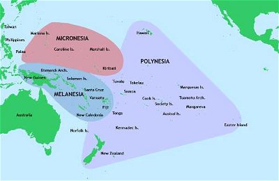
Answer: Micronesia

Micronesia is a region within Oceania, and is made up of thousands of islands. Apart from the Republic of Nauru, there are four other sovereign countries in the region: the Federated State of Micronesia, the Republic of Kiribati, the Republic of the Marshall Islands, and the Republic of Palau. There are also two United States territories in Micronesia: Guam and the Commonwealth of the Northern Mariana Islands.

3. Scholars think that the name Nauru is derived from the native Nauruan word "Anáoero". What does it mean?

From Quiz What? Where? Who? Nauru!

Answer: I go to the beach

Originally there were just seventeen letters in the Nauruan written alphabet, but successive colonial powers brought their languages and influences, and since the 1930s written Nauruan uses twenty-nine letters. Early German settlers called the island "Nawodo", and to the first English visitors and residents it was known as "Pleasant Island".

4. What is Nauru's capital?

From Quiz Nifty Nauru

Answer: No capital

Nauru has no capital and is the world's only independent republic not to have one. Yaren is the island's largest city with about 1,200 people. Yaren, and Aiwo, are often considered the capital, however. Honiara is the capital of the Solomon Islands and Noumea is the capital of the French holding of New Caledonia.

5. believe it or not, nauru is the only country in the world without an official... wait! what is missing?

From Quiz Nice Little Nauru

Answer: Capital

As you may have noticed in the question, all of the capital letters were missing, deliberately. Likewise, Nauru has not officially declared a capital city. This is partly because Nauru doesn't have any cities. Nevertheless, Yaren, a district that houses the national stadium, the country's international airport, as well as the government buildings, is considered the de facto capital, or, as the United Nations calls it, the main district.

6. Nauru's nearest neighbour is Banaba Island, which is 300 kilometres to the east. To which island nation does Banaba Island belong?

From Quiz Nauru - Pleasant Island?

Answer: Kiribati

Nauru is located at 0°32′ South and 166°56′ East. That means that it is only 42 kilometres south of the Equator. As determined in the question, the closest Kiribati island is 300 kilometres away to the east. The nearest of the Marshall Islands is 974 kilometres away to the northeast, the Federated States of Micronesia is 1,271 kilometres northwest, and it is 3,701 kilometres east to Palau.

7. In 1914, Nauru was captured by Australian troops who wrested control from the country who had occupied the island since 1888. Which country was this?

From Quiz What? Where? Who? Nauru!

Answer: Germany

By 1914, Nauru was a prime source of valuable phosphates. Australian troops captured the island and Australia, New Zealand, and the UK formed the British Phosphate Commission to run mining operations.

8. What is the economy mainly based on?

From Quiz Nifty Nauru

Answer: Phosphates

The mining of phosphates has almost completely destroyed the island of Nauru, about 4/5 of the land has been stripped and mined, and the phosphate reserves are nearly gone, leaving the Nauruans with little left to support themselves with. An Australian company began mining phosphate reserves at deeper levels than previously in 2006 and it's expected that these reserves may last thirty years.

9. Nauru's flag represents much of its identity. A central narrow horizontal line represents the equator. What colour is the line?

From Quiz Nice Little Nauru

Answer: Yellow

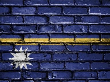
On a field of blue which represents the Pacific ocean, a thin horizontal yellow line crosses in the middle representing the equator. A twelve-pointed white star is to the left just below the equator signifying how Nauru is about one degree south, while the twelve points signify the twelve tribes of Nauru and the white represents the phosphates that made the country prosperous in the past. The flag was designed and chosen in a competition when Nauru became independent since none of the colonial flags were deemed proper to hoist. It is twice as long as it is tall and is reportedly well-liked by citizens of Nauru.

10. Nauru is the smallest (independent) island nation in the world, and only Monaco and Vatican City are smaller independent countries. How small is it?

From Quiz Nauru - Pleasant Island?

Answer: 21 square kilometres

Despite its incredibly small size, the island country is still divided into 14 administrative districts. At one point there were 169 separate villages on the island, but the island's phosphate mining operations left much of the island uninhabitable. The population is spread out along the coastal strip, essentially making one continuous settlement around the edge of the whole island. Nauru also qualifies as the smallest republic in the world.

11. What currency is used in Nauru?

From Quiz Nifty Nauru

Answer: Australian Dollar

The Pa'anga is the currency of Tonga, the Tuvaluan Dollar is the currency of Tuvalu. The Nauruan Rupee is a name I made up.

12. What is the main district of Nauru, containing both the Parliament House and the Nauru International Airport?

From Quiz Nauru - Pleasant Island?

Answer: Yaren

Nauru has no official capital city. In fact, Nauru has no official cities at all. The Yaren district, by virtue of the fact that the Parliament House is there, has come to be recognized by the United Nations as the 'official district' of Nauru.

13. Most of the fresh drinking water in Nauru comes from the Moqua Well. Tarn, what is the Moqua Well?

From Quiz Nice Little Nauru

Answer: An underground lake

The Moqua Well is a subterranean freshwater lake that supplies most of the drinking water to the islanders. It stores rainwater and prevents evaporation, for the most part. It is accessible through the Moqua Caves, but was fenced off in 2001 when someone drowned there. The Moqua Well can be found not far from the airport, in the main district of Yaren.

14. The flag of Nauru is blue with a thin horizontal gold stripe through the middle. There is also a 12-pointed white star just below the stripe and slightly to the left. What do the 12 points of the star represent?

From Quiz Nauru - Pleasant Island?

Answer: The 12 indigenous tribes of the island

The Nauruan flag was adopted on the date of Nauru's independence (from UN trusteeship) on January 31, 1968. The flag's design is very representative of Nauru's geographical location, as well as having a little more symbolism. The golden stripe represents the equator, while the blue field is the Pacific Ocean. The white star represents Nauru's position in relation to the equator, as well as the significance associated with the 12 points and the indigenous tribes. It is white to represent the importance of the economy based on phosphate mining.

15. What level above sea level is the highest point in Nauru?

From Quiz Nifty Nauru

Answer: 71 meters (233 feet)

Nauru's highest point is only 71 meters high and is called Command Ridge.

16. From one of the largest GDPs to one of the worst, Nauru's economy was tied into their main natural resource. What is it?

From Quiz Nice Little Nauru

Answer: Phosphates

In 1907 developers began mining phosphates from Nauru. Abundant because of guano droppings, the phosphates from Nauru were considered by many to be the highest quality in the world. The mining was so intense that Nauruans did not diversify their industry. In the early 1980s, their GDP was the highest per capita in the world. When the phosphates ran out, the people of Nauru were strapped. With no other industry to turn to, this island quickly became one of the poorest countries in the world. At one point, an unemployment rate of 90% was recorded. 80% of the island was deemed uninhabitable, and, yea, the pictures of the inner island look like something out of a science fiction novel.

17. What is the name of the large lake in southwest Nauru?

From Quiz What? Where? Who? Nauru!

Answer: Buada Lagoon

Buada Lagoon is the only significant body of fresh water on Nauru, with the only other sources being rainfall and some small ponds. Apart from the narrow coastal plain around the edges, the land near the Lagoon is the only fertile land on Nauru. Many of the buildings on Nauru have rainwater collection tanks on the roof, and there is a desalination plant to turn seawater into fresh.

18. Nauru's central plateau, holds the location of the island's highest point of elevation at 65 metres. What is the name of this point that was also the site of a Japanese military outpost during World War II?

From Quiz Nauru - Pleasant Island?

Answer: Command Ridge

Whether it was named for the 'military command' that held that place, or for the commanding view that the high feature offered is unclear, but the point certainly bears historical significance. There are still remnants of the Japanese military presence to be found there, including some rusted cannons and a communications bunker.

19. On October 26th each year, Nauruans celebrate Angam Day. What are they celebrating?

From Quiz What? Where? Who? Nauru!

Answer: The population of native Nauruans reaching 1500

In the aftermath of World War I, the population of native Nauruans was dangerously small, and a target of 1500 people was proposed as being the minimum needed to ensure the survival of the nation. The 1500th person was born in 1932, and declared the "Angam Baby". After World War II, the population was again considerably reduced, and the second Angam Baby was born in 1949. Angam Day is now commemorated every year, to give thanks for the survival of the Nauruan people as a race.

20. Nauru experiences a particularly rainy...

From Quiz Nice Little Nauru

Answer: Summer

Being just south of the equator, the months of December through February are considered to be the summer months of Nauru. They are rainier than any other season, with an average of 270mm of rain per month. Spring (September to November) is the driest season with about 113mm of rain on average for those months.

21. Nauruans celebrate Angam Day (Day of Fulfillment) on October 26th. This is in celebration of the date in 1932 that the population regained what level (following a devastating influenza epidemic in 1920)?

From Quiz Nauru - Pleasant Island?

Answer: 1,500 people

The population of Nauru has never been extremely high, and as recently as July, 2011, the population was less than 10,000. After that epidemic in 1920 it took twelve years for the population to build back up to 1,500 people. The 1,500th person was a girl named Eidegenegen Eidagaruwo. During World War II the population again dipped below 1,500, and as long as it remained so, Angam Day was not celebrated. After the Japanese withdrawal, it was not until March 31st of 1949 that 1,500 was reached again with the birth of Bethel Enproe Adam. Since then, Angam Day has again been celebrated (on the original October 26th).
22. What is the motto of Nauru?

From Quiz What? Where? Who? Nauru!

Answer: God's Will First

Almost 80% of Nauruans are Christians, with around two thirds of them Protestant. The island also has followers of Islam, Bahai'a, and Buddhism. There is freedom of religion there, with some governmental control over the practices of the Church of Latter Day Saints and Jehovah's Witnesses.

23. Command Ridge is the highest point of Nauru. Sugoi! What kind of relics are associated with this place?

From Quiz Nice Little Nauru

Answer: Japanese WWII relics

When the Japanese took over Nauru in 1942, they set up an observation strong-point atop Command Ridge, hence the name. When they surrendered the island back to the Australians in 1945, they left much of their military gear on the hill. This includes an abandoned communications outpost, a pair of rotating anti-ship guns, and other ordinance. Known in Nauruan as Janor, this 65m-high hill is the highest point of Nauru. Most countries have buildings higher than that.

24. Finally, I see where Windrush is on Nauru. She is talking to some people who are behind high fences. Where is she?

From Quiz Missing in Nauru

Answer: a detention centre in Medeng District

From 2001 to 2008, and from 2012, Nauru accepted economic aid from the Australian Government in exchange for having Australia's offshore immigration detention centre on their island. The people held in the "Nauru Regional Processing Centre" are asylum seekers. They are from mostly Middle Eastern countries, and tried to get to Australia illegally by boat from Indonesia. The Australian government had a policy called the "Pacific Solution", a total refusal to take illegal immigrants and placed them in detention outside the Australian mainland.

25. When did Nauru become independent?

From Quiz Nifty Nauru

Answer: 31 January 1968

On January 31, 1968, the Nauruans declared independence from Australia. The independence movement began in 1964, and by 1966, Nauru was almost self-governing. In 1968, the UN granted Nauru indepdence and later on that year, it was granted Special Member Status within the British Commonwealth.

26. The most populous place in Nauru is Denigomodu. Many expats live there in a dedicated housing district. What is this living 'place' called?

From Quiz Nice Little Nauru

Answer: Location

Denigomodu is the most populous of the fourteen districts of Nauru, mainly because of the large expat housing area called the Location. As the Nauruan law dictates, a non-citizen may not own land on the island. Neither can, actually, the government. All land on Nauru is owned by its citizens. The Location houses expats who enter a lease with the Nauru Phosphate Corporation. These are mainly workers at the phosphate mining operations. In 2020, Denigomodu had fewer than 2500 inhabitants. While the most populous place on Nauru, it can hardly be called a city. Denigomodu has the only hospital on the island.

27. The central part of the island of Nauru is composed of coral limestone peaks, left behind after heavy phosphate mining. How is this central plateau known?

From Quiz What? Where? Who? Nauru!

Answer: Topside

Topside occupies the majority of the land on Nauru, and has been much damaged by the phosphate mining operations carried out there. There is a programme to regenerate the land, restore vegetation, and repair the environmental damage done by the mining.

28. What is the name of the small, freshwater lagoon on the island?

From Quiz Nifty Nauru

Answer: Buada

Buada is a brackish lagoon in the Buada district in the southeastern area of the island, it is situated on a plateau surrounded by coral cliffs. Ndogo is a lagoon in the southwest of Gabon, Marovo is the world's largest saltwater lagoon which is in the Solomon Islands, and Kotychi is a lagoon in Greece along the Ionian Sea.

This is category 17640
Last Updated Apr 13 2024 5:49 AM
play trivia = Top 5% Rated Quiz, take trivia quiz Top 10% Rated Quiz, test trivia quiz Top 20% Rated Quiz, popular trivia A Well Rated Quiz
new quizzes = added recently, editor pick = Editor's Pick editor = FunTrivia Editor gold = Gold Member

Teachers / educators: FunTrivia welcomes the use of our website and quizzes in the classroom as a teaching aid or for preparing and testing students. See our education section. Our quizzes are printable and may be used as question sheets by k-12 teachers, parents, and home schoolers.

 ·  All questions, answers, and quiz content on this website is copyright FunTrivia, Inc and may not be reproduced without permission. Any images from TV shows and movies are copyright their studios, and are being used under "fair use" for commentary and education.