FREE! Click here to Join FunTrivia. Thousands of games, quizzes, and lots more!
Quiz about The Blue Waters of Cape Verde

The Blue Waters of Cape Verde Trivia Quiz


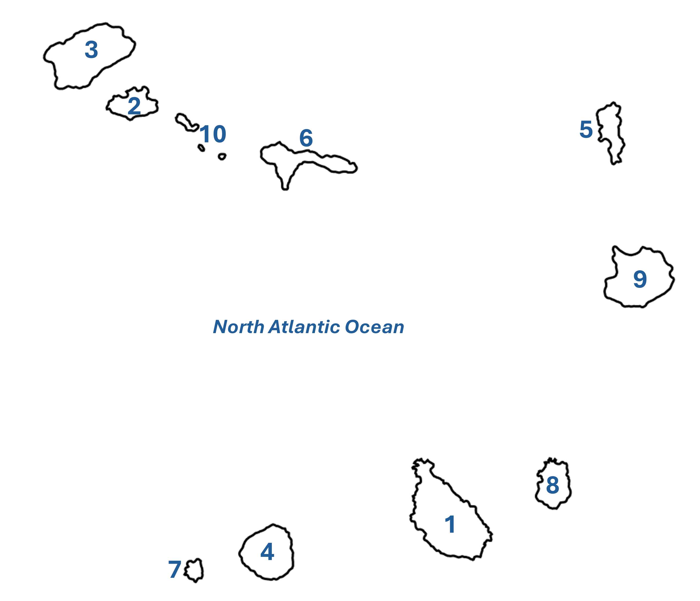
Cape Verde lies off the west coast of Africa in the beautiful, clear blue waters of the North Atlantic Ocean. Your task is to correctly label each of the ten islands of which this picturesque archipelago is made.

A label quiz by VegemiteKid. Estimated time: 3 mins.
  1. Home
  2. »
  3. Quizzes
  4. »
  5. Geography Trivia
  6. »
  7. Africa
  8. »
  9. Cape Verde

Author
VegemiteKid
Time
3 mins
Type
Label Quiz
Quiz #
415,464
Updated
Apr 13 24
# Qns
10
Difficulty
Easy
Avg Score
8 / 10
Plays
36
Last 3 plays: daisygirl20 (10/10), MrNobody97 (10/10), PDAZ (2/10).
Santiago Sal Sao Nicolau Sao Vicente Santo Antao Fogo Brava Santa Luzia Marine Reserve Maio Boa Vista
* Drag / drop or click on the choices above to move them to the answer list.
1.   
2.   
3.   
4.   
5.   
6.   
7.   
8.   
9.   
10.   

Most Recent Scores
Apr 27 2024 : daisygirl20: 10/10
Apr 25 2024 : MrNobody97: 10/10
Apr 21 2024 : PDAZ: 2/10
Apr 20 2024 : lethisen250582: 10/10
Apr 17 2024 : NinJ73: 2/10
Apr 15 2024 : workisboring: 2/10
Apr 15 2024 : Guest 174: 10/10
Apr 15 2024 : looney_tunes: 10/10
Apr 14 2024 : pennie1478: 7/10

Quiz Answer Key and Fun Facts
1. Santiago

Santiago is the largest island of Cape Verde and it is on this island that Cape Verde's capital city Praia is located. Santiago has the largest population of the ten islands that make up Cape Verde.

A kapok tree on Santiago is the oldest on Cape Verde at about 500 years old; it is also the largest tree, around 40m (131ft) high. Santiago is Portuguese for 'Saint James'. The island is 55km (34mi) in length and 29km (18mi) wide. The World Heritage listed town of Ribeira Grande (now known as now Cidade Velha) was founded in 1462.
2. Sao Vicente

Located off the West African coast, Sao Vicente is one of the northern group of the Cape Verde archipelago. At 227 km² (141mi²) it is the third smallest inhabited island of the group, with a population of around 80,000. Mindel, a port city in the northern part of the island, boasts a beautiful harbour bay and the island enjoys a hot desert climate.

The island is of volcanic origin and apart from a couple of large mountains, including Monte Verde which has an altitude of 744m (2,441ft), it is relatively flat.
3. Santo Antao

Santo Antao is the westernmost of Cape Verde's islands, and at 785 km² (488mi²) it is the second largest island. Its highest point is Tope de Coroa, and one of its primary tourist attractions is a large black lava beach at the Bay of Tarrafal de Monte Trigo.

Its spectacular scenery draws people from all over the world, and the tropical climate provides ideal conditions for growing bananas, mangoes, and grain. Sugar cane, another important crop, also provides the raw material for grogue, a rum-like drink unique to Cape Verde.
4. Fogo

Fogo is a volcanic island whose capital is Sao Filipe. It's the fourth largest island with a population of around 36,000. Fogo means fire, reflecting its volcanic origins. The highest peak in Cape Verde is here; Pico de Fogo is 2,829m (9,282ft) high, and takes 3-4 hours to climb. Lasting for an entire week, Fogo's biggest festival, 'Festa de São Filipe', commences on May 1st each year.

The north-east of the island is relatively green in comparison with the rest of the landmass, and is the island's fruit and vegetable growing centre; wine is also grown here.
5. Sal

Sal is Portuguese for 'salt' and the island is named for the two salt ponds that are to be found there. However, its real attraction is the 350 days of sun that it enjoys each year, its fabulous white beaches, and the blue, blue water that provides a backdrop for such activities as surfing, wind-surfing, kite-surfing, and diving.

It's the flattest of the islands of Cape Verde, with an elevation of only 405m (1329ft) at Monte Grande. The island is just 27km (18.5mi) long and 11km (7mi) at its widest point, so is the second smallest inhabited island, and has a population of a bit over 38,000.
6. Sao Nicolau

First settled in the seventeenth century, Sao Nicolau is the fifth largest island of those that make up Cape Verde, at 346km (215mi). It has a population of around 13,000. The island's capital is Ribeira Brava. Located between the islands of Santa Luzia and Sal, Sao Nicolau is one of the Barlavento (windward) islands. Its highest elevation is Monte Gordo, at 1,312m (4305ft).

One of the treasures of the islands is the Cape Verde Dragon Tree, an iconic species native to the islands. Replete with numerous quality hiking trails, the island's natural beauties provide tourists with excellent opportunities for exploration of its beauty spots.
7. Brava

Portuguese for 'wild' or 'brave', the stunning vistas from Brava's highest point, Monte Fontainhas, are breathtaking. From the 976m (3202ft) viewpoint, the peak of the stratavolcano of which the island consists, you can look down on the cities of Furna and Fajã de Água. Nova Sintra, its main town, is slightly inland.

The culture is Creole, and its primary industry agricultural, though the island is also known for its traditional queijo do qachaço (goat cheese) and cachupa (a hominy meat stew). The blue, blue waters that surround the island provide abundant salmon and painted grouper.
8. Maio

Maio is the easternmost of the Sotavento (leeward) islands of Cape Verde, the fourth smallest island with a population of around 8,000 souls. Its capital is Cidade do Maio, where about half of the island's inhabitants reside. First discovered in 1460, it was settled about 100 years later, mostly used for rearing goats.

Among the main attractions of the island are its stunning white beaches which are lapped by the blue waters of the North Atlantic; best of all, they are largely unoccupied. Some are great for bathing, others are surf beaches. It is even possible (from a distance) to observe turtles laying their eggs, or to watch the desert sandpipers, ospreys, and sand larks that make the island home.
9. Boa Vista

Boa Vista is the third largest island in Cape Verde and its name, which means 'good view' in Portuguese, is literally true; it has 55km (34mi) of white beaches, meeting the clear, deep-blue waters of the North Atlantic. There is a growing tourism trade, but still lots of places to find a solitary walk.

Its nickname, the 'Sahara in the Atlantic', gives an indication that this island of all those that make up Cape Verde is the least verdant - you can walk for miles across treeless wasteland in the centre of the island - to get to the next amazing beach!
10. Santa Luzia Marine Reserve

Santa Luzia, with the 'by-islands' of Raso and Branco, are an uninhabited group in Cape Verde, of which Santa Luzia is the main one. The three land masses are part of the 'Reserva Natural Integral de Santa Luzia' nature reserve and are on the provisional schedule of the UNESCO World Heritage List.

The island is a haven for endemic species and they thrive unmolested due to the inhospitable nature of its terrain. The group still enjoys the crystal clear blue water that defines the rest of the country, but suffers drought-like conditions that makes human habitation impossible.
Source: Author VegemiteKid

This quiz was reviewed by FunTrivia editor agony before going online.
Any errors found in FunTrivia content are routinely corrected through our feedback system.
4/29/2024, Copyright 2024 FunTrivia, Inc. - Report an Error / Contact Us