FREE! Click here to Join FunTrivia. Thousands of games, quizzes, and lots more!
Quiz about Cruising the End of the World

Cruising the End of the World Trivia Quiz


Most of these pictures were taken at various ports of call on a cruise of the southern parts of South America. The cruise also entered Antarctica but that part of the cruise is covered in a different quiz!

A photo quiz by skunkee. Estimated time: 4 mins.
  1. Home
  2. »
  3. Quizzes
  4. »
  5. Geography Trivia
  6. »
  7. South America
  8. »
  9. South American Rivers and Oceans

Author
skunkee
Time
4 mins
Type
Photo Quiz
Quiz #
335,332
Updated
Jul 23 22
# Qns
10
Difficulty
Average
Avg Score
8 / 10
Plays
1882
Awards
Top 10% Quiz
Last 3 plays: shorthumbz (8/10), klrunning (5/10), AdamM7 (8/10).
-
Question 1 of 10
1. Our cruise on the Star Princess set sail from this beautiful city, seen at sunset, which is the capital city of Argentina. What is the name of this city? Hint


Question 2 of 10
2. This city is the capital of the Falkland Islands, in fact it's the only real city in the Falklands. What's it called? Hint


Question 3 of 10
3. These rivers of rock, or stone runs, as they are often called, can be found all over the Falkland Islands. These particular runs were photographed on East Falkland. What is the origin of these rivers of sharp-edged and pointed (that's a hint) boulders? Hint


Question 4 of 10
4. The port of call was Ushuaia, Argentina, a city of approximately 80,000 that has the claim to fame of being the southernmost city on Earth. We ended up on a little train, the southernmost railway, that took us to Tierra Del Fuego Park. What's the colourful name by which the train is also known? Hint


Question 5 of 10
5. Leaving Ushuaia, we set sail in the striking beautiful Beagle Channel, named after Darwin's ship, the HMS Beagle. This glacier, located on the northern shore of the Beagle Channel is the Romanche Glacier, although it is often referred to as the 'Weeping Glacier'. What is the source of the waterfall seen below the glacier? Hint


Question 6 of 10
6. We got off the ship in Punta Arenas, Chile, a city of about 120,000 (according to the 2002 census), and got on a bus which took us to a ferry. The ferry ran us out to an island that is home to about 65,000 pairs of mating Magellanic Penguins, and not much else. Which island is this, with a name that is similar sounding, but very different in origin, to the name of the penguins that breed there? Hint


Question 7 of 10
7. It was in Chacabuco, Chile (a town of about 1,300) that we first encountered this amazing tree. What is it? Hint


Question 8 of 10
8. It was at the port of call of Puerto Montt, a city of about 175,000, that our excursion took us up the side of Osorno, pictured here. Is Osorno a volcano?


Question 9 of 10
9. Although photographed in the port city of Valparaiso, Chile, where does this familiar looking head originate from? Hint


Question 10 of 10
10. Although we left the Star Princess in Valparaiso, we had to get to the airport to fly home. The airport was located in the Chilean capital city, also home to this Presidential Palace. What city is this? Hint


(Optional) Create a Free FunTrivia ID to save the points you are about to earn:

arrow Select a User ID:
arrow Choose a Password:
arrow Your Email:


View Image Attributions for This Quiz

Most Recent Scores
Mar 23 2024 : shorthumbz: 8/10
Feb 26 2024 : klrunning: 5/10
Feb 22 2024 : AdamM7: 8/10

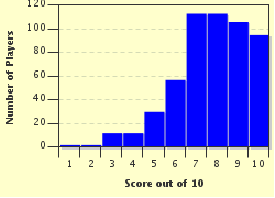
Score Distribution

quiz
Quiz Answer Key and Fun Facts
1. Our cruise on the Star Princess set sail from this beautiful city, seen at sunset, which is the capital city of Argentina. What is the name of this city?

Answer: Buenos Aires

Buenos Aires is the second largest city in South America (Sao Paulo, Brazil is the largest). The 2001 census showed the population to be 12,129,819 people, which was approximately the same as the population of all of the Canadian province of Ontario (12,160,282 people in the 2006 census).
Buenos Aires is situated on the southern bank of the Rio de la Plata, a very wide (220 kilometres at its widest point) river. In some places it is quite shallow, making it a challenge for some of the larger ships. The river forms the border between Argentina and Uruguay.
The average temperatures for Buenos Aires run from 40 degrees Celsius in January (height of the summer) to 14 degrees Celsius in July.
Buenos Aires means good air.
2. This city is the capital of the Falkland Islands, in fact it's the only real city in the Falklands. What's it called?

Answer: Stanley

Stanley is situated on the southern coast of east island. The 2006 census yielded a population of 2,115, which compared with 2,955 people in all of the Falklands (including Stanley), in the census of the same year. (These numbers included military personnel stationed there, but not their families).
The Falklands are a British Overseas Territory, and there has been an age-old dispute between Britain and Argentina about ownership of the islands. In fact we were advised, before going ashore, to refer to them as The Malvinas when in Argentina.
On April 2, 1982 Argentina invaded the Falklands (as well as other British holdings in the area), occupying them until Britain was able to send her forces down to reclaim her territories. Argentina surrendered on June 14, 1982, but in the meantime soldiers had planted many minefields. Some of those minefields have been cleared, but many still exist, complete with warning signs.
The climate is cold and wet, with the highest average temperature only 13 degrees Celsius, and that occurs in January and February.
3. These rivers of rock, or stone runs, as they are often called, can be found all over the Falkland Islands. These particular runs were photographed on East Falkland. What is the origin of these rivers of sharp-edged and pointed (that's a hint) boulders?

Answer: the climate during the last Ice Age, along with the movement of the underlying soil

Rocks left behind by glacial retreat have been dragged across the land by the weight of the glacier. This generally results in more worn, rounded rocks. The quartzite rocks, found in these rivers of rock, are far too sharp-edged to have been subjected to that. These rocks would not have been covered by ice, but they would have been subjected to freezing, thawing and the heaving of the surrounding, underlying rock by frost.

The movement of the soil underneath them, aided by the flow of water and the slope of the land, would have carried them along, as if in a river.

It's quite a remarkable sight.
4. The port of call was Ushuaia, Argentina, a city of approximately 80,000 that has the claim to fame of being the southernmost city on Earth. We ended up on a little train, the southernmost railway, that took us to Tierra Del Fuego Park. What's the colourful name by which the train is also known?

Answer: End of the World Train

After a couple of incarnations as first a mission town and then a naval base, Ushuaia became a convict settlement. The first prison opened in 1896 and the last one closed in 1947. The train tracks were laid by convicts, to transfer convicts. They would generally spend their days chopping down trees, the stumps of which can still be seen along the sides of the tracks.

The height of the stump indicates whether the tree had been felled in the summer or the winter - the deeper the snow, the higher the cut and the larger the remaining stump. The train is a narrow gauge one and, as a tourist attraction, it deposits its passengers in Tierra del Fuego Park.

There you board a bus that takes you Ensenada Bay for some photo opportunities before returning, by bus, to the station.
5. Leaving Ushuaia, we set sail in the striking beautiful Beagle Channel, named after Darwin's ship, the HMS Beagle. This glacier, located on the northern shore of the Beagle Channel is the Romanche Glacier, although it is often referred to as the 'Weeping Glacier'. What is the source of the waterfall seen below the glacier?

Answer: glacial melt

Of the many glaciers nestled in the mountains along the Beagle Channel, only a couple are still advancing. These reach the water's edge and berg bits of glacial ice can be seen floating underneath them. The rest of the glaciers are retreating and no longer reach the water's edge. The Romanche Glacier is melting so quickly, that the run-off forms a waterfall.
6. We got off the ship in Punta Arenas, Chile, a city of about 120,000 (according to the 2002 census), and got on a bus which took us to a ferry. The ferry ran us out to an island that is home to about 65,000 pairs of mating Magellanic Penguins, and not much else. Which island is this, with a name that is similar sounding, but very different in origin, to the name of the penguins that breed there?

Answer: Magdalena Island

Given the fact that Chile is an overwhelmingly Catholic country, it is fair to assume that Magdalena Island was named after Mary Magdalene, although my research has been unable to verify this. Magellanic Penguins were named after explorer Ferdinand Magellan.
Magdalena Island is a small island (about the size of a shopping mall), located in the Strait of Magellan. It is uninhabited except for the penguins, which are burrowing penguins. When we saw them, most of the pairs of mating penguins had two chicks, so there were a lot of penguins to be seen, heard and smelled!
7. It was in Chacabuco, Chile (a town of about 1,300) that we first encountered this amazing tree. What is it?

Answer: Araucaria auracana

This evergreen is the national tree of Chile, and is native to regions in Chile and Argentina. It is part of the conifer genus and can grow to be 40 metres tall, with a trunk that's up to two metres in diameter.
There are male and female trees, but although both of them bear (different kinds of) cones, they do not do so until the tree is mature, at 30-40 years old. An individual tree can live up to 1,000 years and the species has been around for so long that it is sometimes referred to as a living fossil.
This is a seriously cool tree.
8. It was at the port of call of Puerto Montt, a city of about 175,000, that our excursion took us up the side of Osorno, pictured here. Is Osorno a volcano?

Answer: Yes

Osorno is considered an inactive volcano, and its last eruption occurred in 1869. However it was very active in its day, with eleven eruptions recorded between 1575 and 1869. It towers 2,652 metres above Todos Los Santos lake below.
Our bus took us up to the edge of the snow line, where a small skiing facility exists. We were literally above the clouds. Visible, from both the top of Osorno and from the city below, is Volcano Calbuco, an active volcano. Its last eruption, in 1893, literally blew its top off.
9. Although photographed in the port city of Valparaiso, Chile, where does this familiar looking head originate from?

Answer: Easter Island

Although it lies in the Pacific Ocean, over 3,500 km away, Easter Island is a special territory of Chile. It was named because the first European explorer to 'discover' it, did so on Easter Sunday. The island is small (163.6 sq. km) with a population of less than 5,000, as estimated in 2010.

It did, however have 887 of these wonderful stone heads. Two of these have been moved to the Chilean mainland. We were lucky enough to see the one here in Valparaiso.
10. Although we left the Star Princess in Valparaiso, we had to get to the airport to fly home. The airport was located in the Chilean capital city, also home to this Presidential Palace. What city is this?

Answer: Santiago

With an estimate population of almost five million (as of 2007), Santiago is a large city, about an hour's drive away from the port at Valparaiso. Average temperatures range from 30 degrees Celsius in January and February, to 13 degrees in July. The day we were there it hit a very warm 40 degrees.
Although our flight wasn't until late at night, we had to depart the ship in the early morning. In order to pass the day, many excursions were available and the one we took involved tours of both Valparaiso and Santiago, as well as surrounding valleys.
Source: Author skunkee

This quiz was reviewed by FunTrivia editor ozzz2002 before going online.
Any errors found in FunTrivia content are routinely corrected through our feedback system.
3/29/2024, Copyright 2024 FunTrivia, Inc. - Report an Error / Contact Us