FREE! Click here to Join FunTrivia. Thousands of games, quizzes, and lots more!
Ivory Coast Quizzes, Trivia and Puzzles
Ivory Coast Quizzes, Trivia

Ivory Coast Trivia

Ivory Coast Trivia Quizzes

  1. Home
  2. »
  3. Quizzes
  4. »
  5. Geography Trivia
  6. »
  7. Africa

Fun Trivia
4 Ivory Coast quizzes and 40 Ivory Coast trivia questions.
1.
Cote dIvoire Land of Hope
  Cote d'Ivoire, Land of Hope   best quiz  
Photo Quiz
 10 Qns
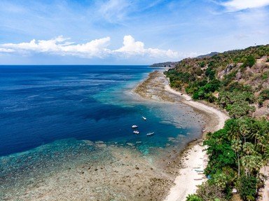
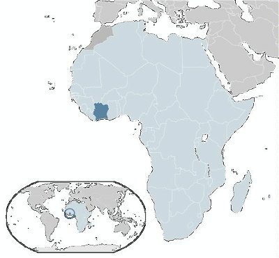
The opening line of "L'Abidjanaise", the national anthem of Cote d'Ivoire, is (in English) "We salute you, oh land of hope". Times may be tough, but there is always hope. (Clicking photos makes them larger if you want to see more detail.)
Easier, 10 Qns, looney_tunes, Aug 25 13
Easier
looney_tunes editor
3689 plays
2.
  Know It All: Ivory Coast!   popular trivia quiz  
Multiple Choice
 10 Qns
Come with me and we can explore the Ivory Coast together! Ivory Coast and Cote d'Ivoire will be used interchangeably.
Average, 10 Qns, jaknginger, Feb 26 14
Average
jaknginger gold member
250 plays
3.
  Where in the World is Yamoussoukro?    
Multiple Choice
 10 Qns
Well, where is it? It's the capital of the Cote d'Ivoire (or just the Ivory Coast) and this is a quiz on that country.
Average, 10 Qns, GreenGal, Oct 22 11
Average
GreenGal
2210 plays
4.
  Geography by Country: Cote d'Ivoire    
Multiple Choice
 10 Qns
This quiz, the second of my Geography by Country quizzes, will explore Cote d'Ivoire. Enjoy learning about some places you've heard of and some you most likely haven't!
Average, 10 Qns, Geomathster, Jul 26 15
Average
Geomathster
179 plays
trivia question Quick Question
Let's see if you know anything of their culture! What is a 'maquis' in the Cote d'Ivoire?

From Quiz "Where in the World is Yamoussoukro?"


Ivory Coast Trivia Questions

1. Which city, although not the official capital, is considered the de facto capital of Cote d'Ivoire?

From Quiz
Geography by Country: Cote d'Ivoire

Answer: Abidjan

While Yamoussoukro is the official capital, Abidjan is the de facto capital and still houses many government buildings and embassies. It is located along the coast and is the country's main port along the Gulf of Guinea. One of the unique features of Abidjan is the 7400 acre Banco National Park, a forested park that is nearly surrounded by the northern suburbs of Abidjan.

2. The Gulf of Guinea borders the Cote d'Ivoire. What body of water includes the Gulf of Guinea?

From Quiz Know It All: Ivory Coast!

Answer: North Atlantic Ocean

Cote d'Ivoire meets the North Atlantic Ocean at its southern border. The Gulf of Guinea is the name for the specific area that runs south and east from Cape Palmas in Liberia to Cape Lopez in Gabon.

3. For those of you particularly tech-wise, what's the Ivory Coast's internet domain?

From Quiz Where in the World is Yamoussoukro?

Answer: .ci

It was introduced in 1995. Some other internet domains are Canada's '.ca', Brazil's '.br' and Ireland's '.ie'.

4. Which two rivers form most of the border between Cote d'Ivoire and Liberia?

From Quiz Geography by Country: Cote d'Ivoire

Answer: Cestos and Cavalla

The Cestos, or Cess, flows along the northern part of the border and then across central Liberia before entering the Atlantic Ocean. The Cavalla, or Cavally, flows from southeastern Guinea through western Cote d'Ivoire and then along the border with Liberia. The Niger, Volta, and Orange are major African rivers, of which only the Black branch of the Volta runs through Cote d'Ivoire at all. The Nzi and Nzo are real rivers in Cote d'Ivoire, but neither is on the Liberia border. There is no Liberia River.

5. In 2012 the Gulf of Guinea was called "The New Danger Zone". What makes the Gulf of Guinea so dangerous?

From Quiz Know It All: Ivory Coast!

Answer: Piracy

The Gulf of Guinea was called "The New Danger" zone by the "International Crisis Group". Incidents of piracy have increased in recent years. The attacks occur closer to shore in territorial waters as opposed to international waters. Providing protection is difficult in these waters due to the inadequate equipment, training and resources of the coast guards and local authorities. Targeted vessels are oil and gas tankers, although other trade shipments are not excluded from attacks. The attacks make not only an impact on the west African economies, they impact the world economies.

6. What is the name of the large area of water south of the Ivory Coast?

From Quiz Where in the World is Yamoussoukro?

Answer: Gulf of Guinea

The Gulf of Guinea covers the countries (in alphabetical order): Benin, Cameroon, Equatorial Guinea, Ghana, Guinea, Guinea-Bissau, Ivory Coast, Liberia, Nigeria, Sierra Leone, and Togo.

7. How long is the Cote d'Ivoire coastline? (Hint: It's about the same as the distance from Chicago to Des Moines.)

From Quiz Geography by Country: Cote d'Ivoire

Answer: 320 miles

The coast of Cote d'Ivoire is on the western part of the Gulf of Guinea. The name Cote d'Ivoire, which means Ivory Coast in English, came from European traders. Names for sections of the African coast included "Gold Coast," "Slave Coast," and "Grain Coast," all of which were based on goods traded at each location.

8. When does the Ivory Coast celebrate Independence Day?

From Quiz Know It All: Ivory Coast!

Answer: August 7

The Ivory Coast's French evolution began in the 1800s. The Ivory Coast was established as a French colony then became a French Republic after World War II. On August 7, 1960, the Ivory Coast became an independent nation. August 7 is a national holiday celebrated with parties, parades and processions.

9. After the 1980's, the Cote d'Ivoire went downhill slightly. The economy was affected, which meant that people became poorer. The president was forced to step down in 1999. A civil war started...but not in 1999. Which year did the civil war start?

From Quiz Where in the World is Yamoussoukro?

Answer: 2002

On September 19, 2002, the country was divided into three parts. There were many murders, quite a few by the government. In 2003, many French and African troops stayed in the Cote d'Ivoire to try and bring peace.

10. Which intersection of latitude and longitude is located in Cote d'Ivoire?

From Quiz Geography by Country: Cote d'Ivoire

Answer: 6 degrees north, 6 degrees west

The intersection of 6 degrees north and 6 degrees west is in southern Cote d'Ivoire near the city of Gagnoa. All of the other points are in the Atlantic Ocean. 0 degrees north/south, 0 degrees east/west (the intersection of the Equator and Prime Meridian) is in the Gulf of Guinea south of Ghana. 11 degrees south, 11 degrees east is just off the coast of Angola.

11. Which historic leader of the Ivory Coast has a peace prize named for him?

From Quiz Know It All: Ivory Coast!

Answer: Félix Houphouët-Boigny

Félix Houphouët-Boigny was the first President of Cote d'Ivoire. Three years prior to his death, UNESCO established the Félix Houphouët-Boigny Peace Prize. It is an annual prize that includes a peace diploma, a gold medal and $150,000. One notable recipient was Nelson Mandela. He shared the prize with F. W. de Klerk in 1991.

12. The Ivory Coast football (soccer) team is quite famous, and they won the 1992 African Nations Cup. They qualified for the 2006 FIFA World Cup, but didn't make it to the second round. Every good team needs a nickname. What's theirs?

From Quiz Where in the World is Yamoussoukro?

Answer: The Elephants

Probably their most famous captain is Didier Drogba, who has played for Chelsea. In the 2008 Africa Cup, the coach dropped out, so Drogba took over as a temporary player/coach, only the second time that has ever happened in the Africa Cup.

13. What large river flows through Lake Kossou in the Ivory Coast?

From Quiz Know It All: Ivory Coast!

Answer: Bandama

The Bandama River is the longest river in Cote d'Ivoire and flows through the country's largest lake, Lake Kossou. Lake Kossou was created by damming the Bandama River. The Kossou Dam is one of the country's sites for hydroelectric power. Buyo and Taabo Dams are the other sites.

14. With its official name (Cote d'Ivoire) and language being French, you can tell that the Ivory Coast has had something to do with France. Although it isn't any more, it became a French colony in 1893. What year did it become independent?

From Quiz Where in the World is Yamoussoukro?

Answer: 1960

On the 7th August, 1960, the Cote d'Ivoire became its own country. A month and a bit later, it joined the United Nations. However, the official language is still French.

15. The land area of Cote d'Ivoire falls between the land areas of which two U.S. states?

From Quiz Geography by Country: Cote d'Ivoire

Answer: New Mexico and Montana

The land area of Cote d'Ivoire is 122,782 square miles, which places it as the 28th largest country in Africa. The land areas of each of the eight listed states are the following: New York- 47,126 sq. mi. North Carolina- 48,617 sq. mi. Minnesota- 79,626 sq. mi. Kansas- 81,758 sq. mi. New Mexico- 121,298 sq. mi. Montana- 145,545 sq. mi. Texas- 261,231 sq. mi. Alaska- 570,640 sq. mi.

16. Three of Cote d'Ivoire's first four World Heritage sites are of what feature?

From Quiz Know It All: Ivory Coast!

Answer: National Parks/Reserves

Although there are other properties on the tenative list, Taï National Park, Mount Nimba Strict Nature Reserve, Comoé National Park, and the Historic Town of Grand-Bassam are the four properties that are on the World Heritage List in 2013. The three parks alone are home to thousands of different species of both flora and fauna, many of which are endangered or at risk.

17. Every country in the world has an official motto. The Ivory Coast's features three virtues; unity, discipline and...can you guess the third?

From Quiz Where in the World is Yamoussoukro?

Answer: Labour

The motto is 'Unity, Discipline and Labour.'. The national anthem is L'Abidjanaise, which means 'Song of Abidjan', although Yamoussoukro is now the capital.

18. Tai National Park, Comoe National Park, Mount Nimba Strict Nature Reserve, and the Historic Town of Grand-Bassam have all received which designation?

From Quiz Geography by Country: Cote d'Ivoire

Answer: UNESCO World Heritage Site

All except for Grand-Bassam were designated World Heritage Sites in the early 1980s. The Historic Town of Grand-Bassam, which was the original capital of colonial Cote d'Ivoire, was designated in 2012. Mount Nimba and Comoe are both considered "in danger." I have never encountered any of the four on any list of Seven Wonders of the World, and the other two designations do not exist.

19. The Ivory Coast is the world's largest producer of cocoa beans. Which statement best describes where the cocoa beans grow?

From Quiz Know It All: Ivory Coast!

Answer: From trees under the canopy of shade trees in rainforest regions

Cocoa trees thrive under the canopy of the rainforest. They need good, rich soil, the humidity of the tropics, and shade of the trees that make up the rainforest to grow. The trees produce 20-30 pods per year. Each cocoa pod can contain 20-60 seeds or beans. It takes an entire tree's annual crop to equal 450 grams, or almost one pound, of chocolate!

20. The Ivory Coast's flag is orange, white and green. Which other (European) country is there that has those colours in its flag?

From Quiz Where in the World is Yamoussoukro?

Answer: Ireland

The two flags contain the same colours, but the Irish one is (from left to right) green, white, orange. The Ivory Coast flag is the opposite. Each colour in the flag (not the Irish one) represents something. The orange is the land, the savannah and the fertility. The white means (what else?) peace. The green symbolises hope, but also the forests. The flag was first used in 1959.

21. In comparison to states in the U.S., what state is closest to the size as Ivory Coast?

From Quiz Know It All: Ivory Coast!

Answer: New Mexico

Ivory Coast is 124,502 square miles. The country is divided into regions and further divided into departments. There are nineteen regions and eighty-one departments that make up the Ivory Coast. Of the states in the U.S., New Mexico is the closest in size at 121,589 square miles and is the fifth largest state in land area. Alaska is the largest U.S. state at 663,267 square miles. Wyoming is the tenth largest at 97,813 square miles. Delaware is the 49th largest, or next to the smallest, state in total land area at 2,489 square miles. Rhode Island is the smallest U.S. state in land area. (All totals are approximate within 5 square miles.)

22. Abidjan is considered an economic capital. In what region of Ivory Coast would you find it on the map?

From Quiz Know It All: Ivory Coast!

Answer: Southeast

Abidjan is on the coast of Cote d'Ivoire in the southeast. In 1960 it became the capital of the newly independent Republic of Cote d'Ivoire. In 1983 the political capital was moved to Yamoussoukro. Abidjan is an important port for the Ivory Coast and has a population over 3.5 million!

23. Despite their prowess at football, the Ivory Coast has not performed as well at the Olympics. Gabriel Tiacoh came second in the men's 400 metres when the Games were held in Los Angeles. What year was that?

From Quiz Where in the World is Yamoussoukro?

Answer: 1984

The Ivory Coast has never sent a team to the Winter Olympics, but has taken part in the Summer Olympics every year except 1980.

24. Mount Nimba Strict Nature Preserve lies on the border of three African countries including the Ivory Coast. Can you name the other two?

From Quiz Know It All: Ivory Coast!

Answer: Liberia & Guinea

The Mount Nimba Strict Nature Preserve lies on the western border of the Ivory Coast. It also lies within the countries of Liberia and Guinea. Liberia is a coastal country that is on the southwestern side of the Ivory Coast. Guinea is directly north of Liberia sharing the west-northwestern border with the Ivory Coast.

25. Every year the Fete du Dipri is held. Its purpose is to send away evil night spirits, and has the women and children dancing at midnight until sunrise, when the chief sends them into trances. When is this festival held?

From Quiz Where in the World is Yamoussoukro?

Answer: April

Another festival held is the Fêtes des Masques (Festival of Masks) which is in November every year. There are competitions between villages to find the best dancers. Every March, there is also a week-long carnival.

This is category 20351
play trivia = Top 5% Rated Quiz, take trivia quiz Top 10% Rated Quiz, test trivia quiz Top 20% Rated Quiz, popular trivia A Well Rated Quiz
new quizzes = added recently, editor pick = Editor's Pick editor = FunTrivia Editor gold = Gold Member

Teachers / educators: FunTrivia welcomes the use of our website and quizzes in the classroom as a teaching aid or for preparing and testing students. See our education section. Our quizzes are printable and may be used as question sheets by k-12 teachers, parents, and home schoolers.

 ·  All questions, answers, and quiz content on this website is copyright FunTrivia, Inc and may not be reproduced without permission. Any images from TV shows and movies are copyright their studios, and are being used under "fair use" for commentary and education.