FREE! Click here to Join FunTrivia. Thousands of games, quizzes, and lots more!
Quiz about Mapping Roman Britannia

Mapping Roman Britannia Trivia Quiz


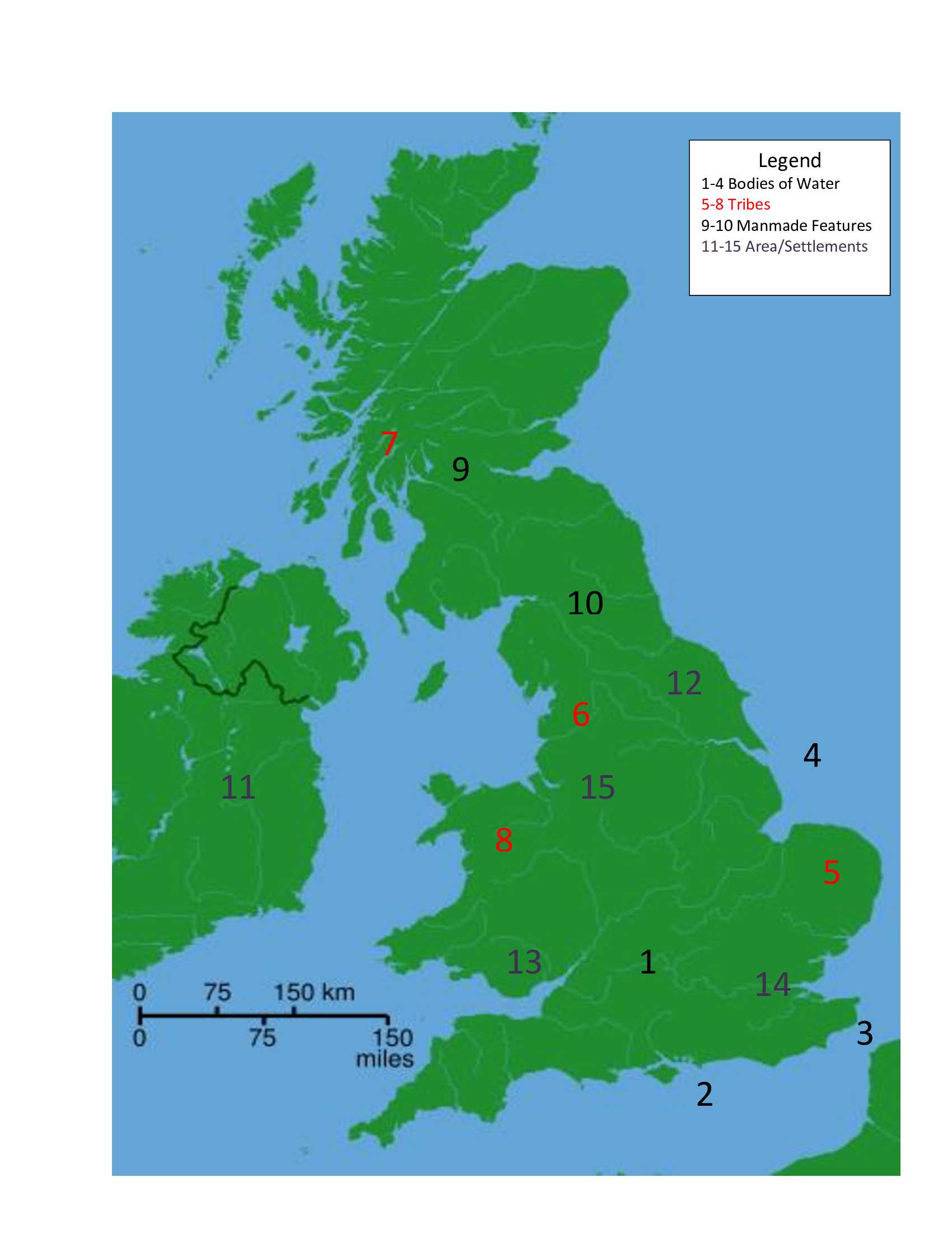
The Romans began their conquest of Britannia in 43 AD, and ruled the land as part of their empire until 410. Look at the map's legend and see if you can identify bodies of water, tribes, man made features, and settlements in Roman Britannia.

A label quiz by ponycargirl. Estimated time: 3 mins.
  1. Home
  2. »
  3. Quizzes
  4. »
  5. History Trivia
  6. »
  7. UK History
  8. »
  9. Romans in Britain

Author
ponycargirl
Time
3 mins
Type
Label Quiz
Quiz #
412,813
Updated
Jun 04 23
# Qns
15
Difficulty
Average
Avg Score
10 / 15
Plays
241
Awards
Top 10% Quiz
Last 3 plays: Guest 171 (11/15), AndySed (7/15), dryvalley51 (11/15).
Iceni Brigantes Hibernia Hadrian's Wall Tamesis Antonine Wall Mamucium Mare Britannicum Isca Silurum Ordovices Fretum Gallicum Londinium Mare Germanicum Eboracum Caledonii
* Drag / drop or click on the choices above to move them to the answer list.
1.   
2.   
3.   
4.   
5.   
6.   
7.   
8.   
9.   
10.   
11.   
12.   
13.   
14.   
15.   

Most Recent Scores
Apr 09 2024 : Guest 171: 11/15
Apr 07 2024 : AndySed: 7/15
Apr 06 2024 : dryvalley51: 11/15
Apr 02 2024 : Guest 79: 6/15
Mar 27 2024 : Guest 5: 0/15
Mar 25 2024 : piperjim1: 15/15
Mar 24 2024 : crossesq: 7/15
Mar 06 2024 : Guest 82: 2/15
Feb 23 2024 : Guest 97: 2/15

Quiz Answer Key and Fun Facts
1. Tamesis

Tamesis was the Latinized version of Tems, an older name used for the Thames River, which means the 'dark one'. Julius Caesar is credited with giving the river this name when he crossed in 54 BC chasing a rebellious warlord. While Caesar wrote about his two side trips to Britannia in 55 BC and again in 54 BC during his conquest of Gaul, the exact movements of his troops there are still debated.

If indeed the Roman invasion of Britannia in 43 AD began somewhere in the county of Kent, as some historians have suggested, it is likely that they sailed the Tamesis to find the site of Londinium. There the Romans also built what is believed to have been the first bridge to cross the river, a wooden one near the present day site of London Bridge.
2. Mare Britannicum

Mare Britannicum, which translates to British Ocean or British Sea, is called the English Channel today. While historians believe that the Channel was used for trading with the continent as far back as 8,000 years ago, Julius Caesar was probably the first Roman to lead men across it in 55 BC.

It was not, however, until 43 AD that regular trading between ports in Roman Gaul and Britannia took place.
3. Fretum Gallicum

The exact route of Claudius' invasion of Britannia in 43 AD has been discussed by historians for centuries. The problem is that nothing much was written about the invasion at the time it occurred. The Roman historian, Suetonius, wrote that Claudius left from Gesoriacum, which is modern day Boulogne, France, in his book, "The Twelve Caesars", published in 121 AD. Can we assume that the soldiers left from the same port? A voyage across the Fretum Gallicum, today known as the Strait of Dover, from Gesoriacum to Dubris (modern Dover) in Kent would have been the fastest way to get troops to Britannia.

Approximately 150 years later, Cassius Dio, another Roman historian, was the first to write about the invasion itself in his "Roman History". His description of the route makes it sound as if the invasion may have been launched from the Rhine River region. The debate continues....
4. Mare Germanicum

Today's North Sea, called Mare Germanicum (German Sea), Oceanum Germanicum, (German Ocean), and Septentrionalist Oceanus (Northern Ocean) by the Romans was first explored in 12 BC. At that time Emperor Nero provided for the building of a fleet and its launch was for the purpose of conquering native peoples who lived in the area. Seven years later the Romans had already explored was far as the Elbe River in modern day Germany, as well as the coast of Denmark. Well before the Viking Age, Romans goods and coins were valued in Scandinavia, and they weren't always acquired through peaceful trade!

Although the North Sea was a prime commercial area before the conquest of Britannia by the Romans, it was also used for fishing and whaling; there was, however, nothing much documented regarding its use until the Roman invasion of Britannia in 43 AD. When the Roman Empire left Britannia in 410 AD the Migration Period of Germanic tribes across the North Sea, including the Angles, Saxons, and Jutes, began as the groups crossed the sea to stake their claim to the land.
5. Iceni

By the time the Romans invaded Britannia in 43 AD, the Iceni were an important tribe that lived in the southeastern part of the island. The two groups apparently got along well together in the beginning; the historian Tacitus wrote that rather than be conquered by the Romans, the Iceni formed an alliance with them. There was a bit of an uprising in 47 AD, when the Roman governor threatened to disarm them, however, the Romans defeated the Iceni and continued to allow their independence.

That changed in 61 AD, when the leader of the Iceni, Prasutagus, died. Rather than leaving his kingdom to Rome as expected, Prasutagus left his kingdom to both the Roman Emperor and his daughters. After the Romans seized the kingdom, and violated Prasutagus' wife, Boudica, and her daughters, Boudica led a revolt that saw the destruction of three Roman settlements before the Iceni were defeated.
6. Brigantes

The Brigantes were people who were living in the northern part of Britannia, in the area mostly known as Yorkshire today; they controlled the most territory in Britannia at the time of the Roman invasion, which may mean that they were the most powerful tribe. Pliny said that the Brigantes occupied nine main cities, as well as other settlements.

When the Romans first encountered the Brigantes they were ruled by Queen Cartimandua. She and her husband became Roman allies, and, with their assistance, the Romans were able to put down a rebellion of a neighboring tribe. Her own people, however, believed she went too far when she turned the rebellious leader over to the Romans, and then decided to divorce her husband. She was forced to flee and very little is known about what happened to her.

The Greek author, Pausanias, wrote that the Brigantes were finally defeated by the Roman Emperor Antonius Pius sometimes in the 140s.
7. Caledonii

The Caledonii lived in northern Britannia in the area called Scotland today, which the Romans called Caledonia. Also called Picts, it appears that they formed a confederation of tribes that carried on continuous raids in the northern boundaries of Roman rule in Britannia.

These raids are believed to have made the construction of two defensive walls necessary as the Romans sought to subjugate the Caledonii and expand their empire to the north. In 180 AD the Picts breached Hadrian's Wall, but were finally contained, although continued attacks on Roman garrisons were common.

Archaeological evidence, such as coins and jewellery, suggests that the two groups did engage in peaceful trade at least part of the time during Rome's occupation of Britannia. Some historians believe that the reason for the building of Hadrian's Wall might have been not only defensive, but commercial as the Romans sought to regulate trade between the two groups.
8. Ordovices

Many of the Celtic tribes in Britannia made alliances with the Romans, but the Ordovices were not one of them! Their leader, Caratacus, organized the resistance to Roman rule, and by the 50s AD he was considered to be a public enemy of the Romans. Located in approximately what is Wales today, the Ordovices were finally conquered by the Romans in 77-78 AD.

While Ptolemy said that the group had two sizeable towns, neither of them has been found.
9. Antonine Wall

Construction on the Antonine Wall began in 142 AD; it consisted of a stone foundation with earthen fortifications. It was approximately 39 miles (63 kilometers) long, 10 feet (3 meters) high, and 16 feet (5 meters) wide. Evidence of a deep ditch for further protection has been found on the northern side of the wall, and historians believe there was a wooden fort built on top of the wall.

Sixteen forts, as well as smaller outposts, were built along the length of the wall, and a road called the Military Way joined all of the sites. It took about 12 years to complete the fortification, which was abandoned after being used just 8 years. At the time of its construction, it was considered to be the northern-most boundary of the Roman Empire.
10. Hadrian's Wall

After Hadrian became Emperor in 117 AD, there were rebellions all over the Roman Empire, including Britannia. The Romans were experiencing problems with Pict raiding parties in the northern reaches of their power, and in 122 AD decided to build a defensive wall as a deterrent.

Hadrian's Wall was approximately 73 miles (117 kilometers) long, 8 feet (2.4 meters) wide (depending on the terrain), and, according to an ancient writer, 12 feet (3.7m) high. Pits called cippi were dug on the barbarian side of the wall, which were filled with sharpened stakes. Deep ditches were also placed strategically along the wall. A watchtower was constructed every third of a mile, and larger forts were placed strategically along its route. Historians estimate that 15,000 soldiers built the wall in about six years.
11. Hibernia

The Romans never actually invaded and claimed Ireland as part of their empire, however, they did travel there for trade. By 98 AD the Roman historian Tacitus was using the name Hibernia for the island, which meant 'land of winter'.

Historian think that when Ptolemy drew his world map c. 150 AD, he used information believed to have been obtained from Roman traders. In addition, the discovery of Roman coins and jewelry gives credence to the idea that Romans visited the island and established trading relations with the people there. The sea between Britannia and Hibernia, appropriately named Mare Hibernicum, is called the Irish Sea today.
12. Eboracum

Also written as Eburacum, Eboracum was founded in 71 AD as a military fortress; it was an especially good location for a fort because the land was flat and near water. Built by the members of the Ninth Legion, the fortress of 5500 men quickly became a civilian settlement as well, attracting people from all over the Roman Empire.

While much of the city's early economy was based on the needs of its military operations, it eventually became a busy port, with skilled workers manufacturing pottery and jewellery. Eboracum became the most important military base in northern Britannia, and by 237 it was designated as a colonia, which was the highest status a Roman city could achieve. There were only four coloniae in Britannia, and while the other three were cities that were founded for retired soldiers, Eboracum was designated as the capital of northern Britain. Today the city is called York.
13. Isca Silurum

Also called Isca Augusta, or simply Isca, Isca Silurum was one of three permanent military fortresses of the Roman legion in Britannia. It was founded c. 74 AD, after the Romans finally subjugated the pesky Silures tribe in the modern region of southern Wales. Isca served as the base of the Legion II Augusta until at least 300 AD. Today it is the modern town of Caerleon.

Originally made of earth and timber fortifications, sometime around 99 AD stone walls were added to the structure. The walls that remain today are 12 feet high in some places, and up to 5-1/2 feet wide. Eventually many buildings were located on the base, including a hospital, barracks, bath house, and an amphitheatre, believed to have been used for gladiator contests, parades, and military training.
14. Londinium

Londinium, modern day London, was founded c. 47 AD, and was chosen to be the capital of Britannia because of its great location for trade on the Thames River, which the Romans called Tamesis. It began as a Roman vicus, or village, and soon became an important location for trade, both by sea and land, as almost half of the roads the Romans built in Britannia ran through Londinium.

Although the town was sacked and burned during Boudica's Revolt in 60-61 AD, it was quickly rebuilt in the Roman style, and over time had a forum, basilica, baths, cathedral, amphitheatre, and an impressive wall. The city eventually became the provincial capital of Britannia, and, at its peak, is believed to have had a population of approximately 60,000 people.
15. Mamucium

Mamucium, located near the city of Manchester today, was founded as a Roman turf and timber fort in 79 AD. It was built to house about 500 soldiers, and over time a nearby vicus, or village, supported them. The original fort was destroyed by 160 AD; at that time it was expanded and rebuilt. By 200 AD the gatehouses were reconstructed using stone, and the walls of the fort were fortified with stone facing.

Interestingly, the ruins of Mamucium remained in plain view of Manchester until the city needed to be expanded during the Industrial Revolution.

At that time a new railroad and canal were constructed, and most of the old fort was destroyed.
Source: Author ponycargirl

This quiz was reviewed by FunTrivia editor gtho4 before going online.
Any errors found in FunTrivia content are routinely corrected through our feedback system.
Related Quizzes
This quiz is part of series Pony's Author Gallery 2:

These quizzes were written in May and June 2023 to fulfill requirements for the Author Gallery.

  1. Exploring Elba! Average
  2. Listing Lakes Conventionally Average
  3. A Brief History of Time BC Tough
  4. King Charles III and Succession Very Easy
  5. State Nicknames With a Twist - 4 Very Easy
  6. Mapping Roman Britannia Average

4/19/2024, Copyright 2024 FunTrivia, Inc. - Report an Error / Contact Us