Last 3 plays: pagea (8/12), ozzz2002 (12/12), chianti59 (8/12).
Click on image to zoom
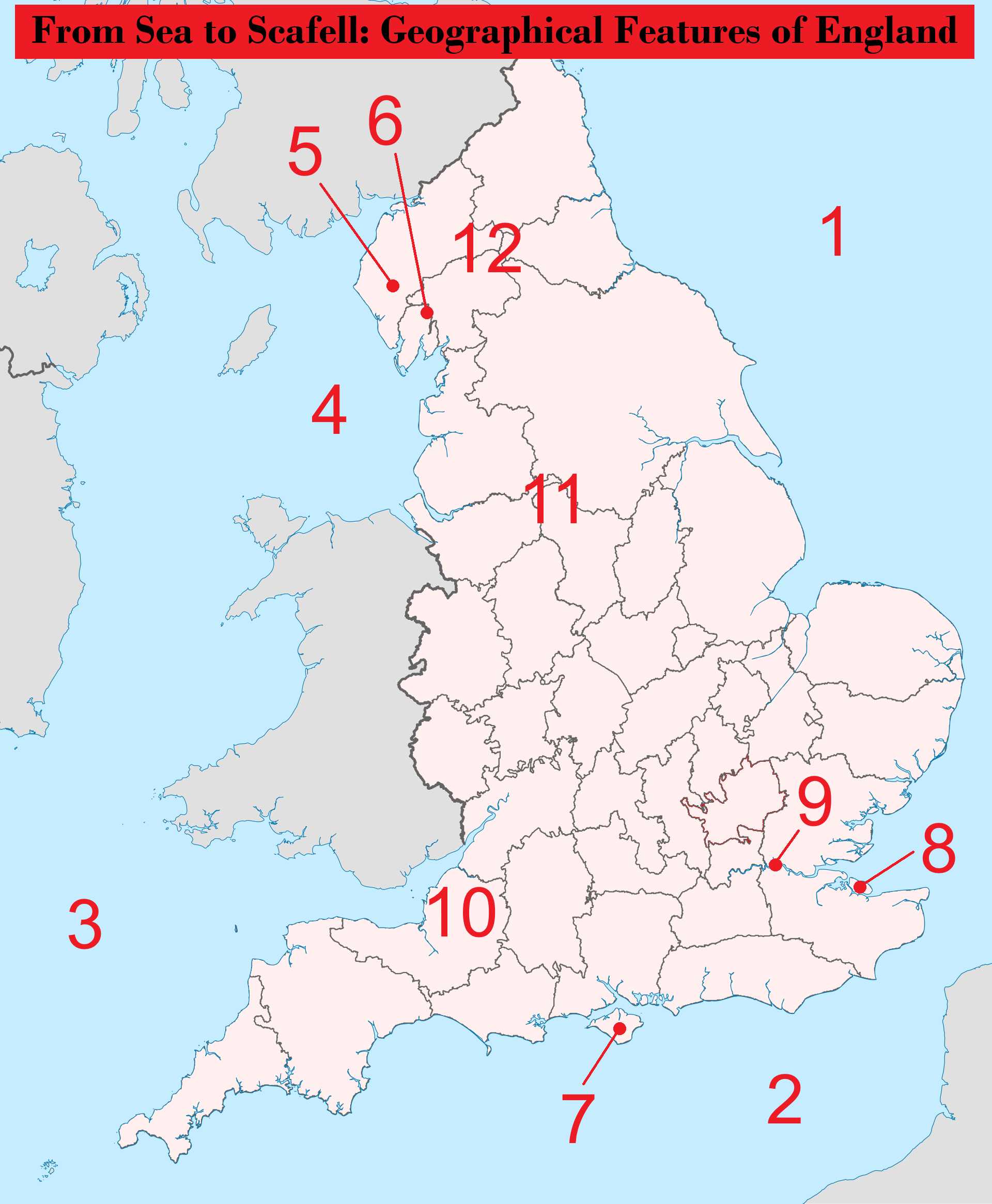
WindermereNorth SeaIrish SeaIsle of WightNorth PenninesScafell PikeCheddar GorgeEnglish ChannelPeak DistrictCeltic SeaIsle of SheppeyRiver Thames* Drag / drop or click on the choices above to move them to the answer list. View Image Attributions for This Quiz
The North Sea is a marginal sea of the Atlantic Ocean, mostly enclosed by Great Britain, Denmark, Norway, Germany, The Netherlands, Belgium and France. It connects to the main body of the Atlantic Ocean via the narrow English Channel in the south, and the broader Norwegian Sea in the north. It also connects to the Baltic Sea, via the small Scandinavian seas of Skagerrak and Kattegat, and the Danish Straits.
The North Sea lies mostly over the edge of the continental shelf of Europe, giving it a rather shallow average depth of 95 metres (311 feet). The main exception is the long but narrow Norwegian Trench, reaching depths of up to 700 metres (2,300 feet) along the Norwegian coast. This trench was carved out by ice stream erosion during glaciation events in the last million years, and it poses challenges for underwater pipeline and cable projects in the otherwise shallow sea.
The shallowest southern portion of the North Sea hides a hidden world, inhabited by prehistoric humans and Neanderthals when sea levels were much lower during glaciation events. Called Doggerland, this region formed a land bridge between the European continent and the British Isles. It was gradually flooded between 10,000 and 7,000 years ago as sea levels rose at the end of the most recent glaciation. It is the subject of many archeological investigations, with excavation findings including Neanderthal skull fragments, remains of animals including mammoths and lions, and Neolithic artefacts such as fish spears, axes, and flint.
People in the Netherlands have, in some sense, been attempting to bring back a scaled-back version of Doggerland for centuries with their widescale land reclamation projects. Using a series of dikes to hold out the North Sea, and draining the enclosed marshlands to create polders fit for agriculture, they have reclaimed over 1,600 square kilometres (640 square miles) of land from the North Sea. With 26% of its land area, and 21% of its population, located below sea level, there's a lot of truth to the common remark that "God created the world, but the Dutch created the Netherlands".
The North Sea has long been a hub of human activity, thanks to its proximity to densely inhabited European countries. From the early sailing of the Romans and Vikings, to the Dutch and English empires, to major battles in WWI and WWII, to modern cargo shipping, there is a rich maritime history. It has also been an economic hotspot for fishing, whaling, oil and gas production, sand and gravel dredging for use in land reclamation, and renewable energy projects including offshore wind farms and wave (tidal) power stations. The beaches and coastlines of its seven bordering countries draw in numerous tourists.
2. English Channel
The English Channel separates southern England from northern France, and connects the North Sea in the east to the Celtic Sea and wider Atlantic Ocean in the west. With a length of about 560 km (350 miles), its narrowest stretch is just 34 km (21 miles) across at the Strait of Dover, and its widest section is 240 km (150 miles). It is even shallower than the North Sea, with an average depth of 63 metres (207 feet), and a maximum depth of 174 metres (571 feet). Along with the North Sea, it took its modern form when it was flooded by rising sea levels when the last glaciation event ended between 10,000 and 7,000 years ago.
The English Channel has had many names through its history. While early Anglo-Saxon texts referred to it as the "South Sea", the modern name seems to have derived from outsiders, including Romans and the Dutch. Naturally, the French reject the anglocentric name used in the English-speaking world, instead calling it la Manche (the sleeve), presumably due to its sleeve-like shape. Other languages have adapted their names for it from the French etymology, like Italian (Canale della Manica), German (Ärmelkanal), and Spanish (Canal de La Mancha).
The English Channel was a key factor in the dominance and long-term stability of the British Empire over centuries gone by. It allowed easy entry for early seafaring people, but later provided a defensible natural barrier to any further sea invasion. With no land routes to Europe, it necessitated naval dominance for trade and regional security, which then encouraged the development of a more global empire. Its strategic location as a chokepoint for trade to Western Europe gave Britain a decisive advantage in WWI and WWII.
French and English relations have also been coloured by their separation across the English Channel. Over the centuries, there have been wars of conquest and competition between their global empires, alternating with periods of strong alliances. The separation is just enough to keep their languages distinct, but allowed for significant diffusion of words between Old English and Old French, resulting in an eclectic mix of similarities and differences. In modern times, the two countries have strong political and military ties, and engage in plenty of light-hearted banter at each other's expense.
Modern transport links across the English Channel include about a dozen ferry routes, and the landmark Channel Tunnel between Folkestone, England and Calais, France. Stretching for 50 km (31 miles) at a depth of up to 75 metres (246 feet), it was an engineering marvel for its time when it opened in 1994. With tunnelling starting from both sides of the Channel in 1988, the French and English teams met in the middle after two years, misaligned by just 30 cm (12 inches) horizontally and 8 cm (3.1 inches) vertically. The Channel Tunnel is a railway tunnel only, but the trains can carry freight, lorries, private vehicles including cars and campervans, and passengers. Much to the chagrin of the public, proposals for a road link for private vehicles were scuppered by concerns about ventilation, and evacuation following accidents and fire.
Numerous islands lie within the English Channel. From the English perspective, the major islands are the Isle of Wight (which we will discuss later on), and the Channel Islands of Jersey and Guernsey. The latter two lie just off the coast of Normandy in France, but are politically aligned with the United Kingdom as Crown Dependencies (along with the Isle of Man, as we shall also discuss later on). Despite their geographic commonalities and proximity, Jersey and Guernsey have been administered separately since the 13th century, in jurisdictions called "bailiwicks" with separate laws, elections, and representative bodies. From the French perspective, there are a few small inhabited islands just off their coast, but none of notable size.
3. Celtic Sea
The Celtic Sea is the next sea to border England. In the east, it is bound by the English Channel, England's southwest coast, and the Bristol Channel; to the north, by the Irish Sea and south coast of Ireland; and on the south and west it becomes the Atlantic Ocean when the continental shelf drops away. Thus, being located on the continental shelf, its depth is similar to that of the North Sea and English Channel, averaging 50-100 metres (165-330 feet).
The name of the sea refers to the Celtic peoples that have inhabited the adjacent islands since prehistory, from whom the present-day languages or dialects of Irish, Welsh, Scottish Gaelic, Manx, and Cornish derive. The name only became commonplace in the late 20th century, adopted by France (la mer Celtique) before English-speaking countries caught on. Prior to that, the region had been referred to as the Southwest Approaches, being the final stretch of water before reaching the British Isles or the English Channel from the Atlantic.
The Isles of Scilly lie within the Celtic Sea, about 45 km (28 miles) from Land's End, the southwestern tip of Cornwall in England. These islands have a rich history, occupied by people for millennia. Around 2,000 people live there today, mostly descended from Celtic peoples, though the traditional Cornish language was largely displaced by English by the 1700s. Owing to their uninterrupted access to the moderating climate effects of the Atlantic Ocean, the Isles of Scilly have lower summer highs and higher winter lows than mainland England, making them a popular tourist destination.
There is less economic activity within the Celtic Sea compared to the North Sea. While it is a rich area for commercial fishing, oil and gas exploration has been less commercially successful, and offshore renewable energy projects lag behind those in the North Sea.
4. Irish Sea
The final sea to border England is the Irish Sea, separating the west coast of England and Great Britain from Ireland's east coast. It connects to the Celtic Sea via the St George Channel in the south, and to the Atlantic Ocean via the North Channel in the north. The western part of the Irish Sea is a deeper channel, ranging from 80-275 metres (260-900 feet), while the bays in the east are much shallower at around 50-100 metres (165-330 feet). It is the only water body that borders all of the countries and constituent countries in the British Isles - Ireland, Northern Ireland, Scotland, England, and Wales.
The Irish Sea forms a crucial sea link between Ireland and Great Britain, with millions of tonnes of cargo, and millions of passengers, making the crossing each year. There have been numerous proposals to build a road/rail tunnel/bridge connection between the two islands, but several challenges have made it less feasible than the Channel Tunnel between England and France. The distance is larger, most proposed routes cross much deeper sections of the sea, the rock is not as soft and easy to drill through, and even the railway gauge differs between Ireland and Great Britain. It remains unclear if the economic and cultural benefits of such a link would justify the lofty price tag such an endeavour would doubtless attract.
The Isle of Man lies conspicuously in the centre of the roughly circular northern section of the Irish Sea. This self-governing British Crown Dependency is home to the Manx people, descended from Celtic and Viking peoples. It is home to Tynwald, the oldest continuous legislature in the world, operating since at least the 13th century. Similar to the Parliament of the United Kingdom, it is a bicameral system with a democratically elected House of Keys, and an indirectly chosen Legislative Council. Locals are proud of their independent identity, Manx language, and rich history.
At first glance, the Isle of Man appears to be the largest island in the Irish Sea. Closer inspection shows that the larger Isle of Anglesey is actually separated from the mainland of Wales by the narrow Menai Strait, carved out by glacial erosion along a fault line. The strait is as narrow as 260 metres (850 feet), and as shallow as 0.5 metres (1.6 feet) in parts during a spring low tide. The Isle of Anglesey is home to the village of Llanfairpwllgwyngyllgogerychwyrndrobwllllantysiliogogogoch, Welsh for "St. Mary's Church in the hollow of white hazel near a rapid whirlpool and the Church of St. Tysilio near the red cave". Originally named just Llanfairpwllgwyngyll ("St. Mary's Church in the hollow of the white hazel"), there is speculation that the lengthening was a publicity stunt to give it the longest railway station name in Britain. The real history is less clear, as there were many similarly long variations used prior to this. Either way, the whimsical name charmed me enough to take the detour when travelling from Cardiff to Scotland on my first visit to Great Britain from Australia. I got a photo with the sign at the railway station and bought fish and chips from a lovely local lady at the local chippery, and loved every minute of the brief visit.
5. Scafell Pike
Scafell Pike is the tallest peak in England, standing at an elevation of 978 metres (3,209 feet). It lies within the Lake District in northwest England, a beautiful region of volcanic peaks and ribbon lakes shaped by glacial action.
The name Scafell Pike is rather unique in mountain nomenclature, retaining the archaic words "fell" (Old Norse for mountain or landscape above the tree line) and "pike" (Old English for a sharp peak or mountain summit). The "sca" portion has a less clear origin, but is perhaps corrupted from "skalli" (Old Norse for bald summit) or "skagi" (Old Norse for peninsula, headland, or promontory).
Scafell Pike is part of the larger Scafell Massif, the significantly eroded remnants of a caldera stratovolcano that emerged 450 million years ago in the Ordovician period. It is comprised mostly of igneous rocks, including breccia, andesite, and rhyolite. The rugged shape of the peak and surrounding landscape has been scoured by glaciers several kilometres (miles) thick during previous glaciations. The summit is a large boulder field, thought to have been created through frost-wedging breaking up the solid rock summit over time.
Scafell Pike is a popular walking destination, with numerous non-technical routes to the summit. The most significant challenge comes from the featureless boulder field at the top, where the trails disappear and climbers must negotiate uneven ground, with boulders ranging from a few centimetres (inches) to metres (feet) in size. During conditions with poor visibility, this can cause significant disorientation, and sure footing is required to avoid broken ankles. Successful summiters are greeted with a 3 metre (10 foot) tall rock cairn at the summit, which covers the natural summit of the mountain. As I was researching this quiz, I was trying to remember what the boulder field and rock cairn looked like during my visit in 2023, before I realised that I had actually climbed nearby Helvellyn. Somehow my brain had filed it away as Scafell Pike this whole time!
6. Windermere
Windermere is the largest lake in England by length, area, and volume, located just a stone's throw away from Scafell Pike in the Lake District. It is a ribbon lake, characterised by a long and narrow, finger-shaped appearance. It was formed when a steep river valley was scoured out and deepened by glacial action over successive glaciations. It is actually a combination of two separate basins - a north basin of hard volcanic rocks, and a south basin of softer shales. It is supplied by numerous mountain streams and rivers, and drains via the short 13 km (8 mile) River Leven into the nearby Irish Sea.
"Mere" is an Old English word for a lake or marshland, usually referring to water bodies that are shallow in depth compared to their width, such that the water temperature is relatively consistent throughout their depth. However, Windermere is deep enough to have a thermocline (a gradient of water temperatures as depth increases), thus the name is actually a slight misnomer. Though the name Windermere already implies that it is a lake, it is sometimes referred to as Lake Windermere to differentiate it from the town of Windermere.
The town of Windermere is not actually located on the lakeside, but 800 metres (half a mile) away, about a 20 minute walk. The town sprang up from the open fell and farmland around the terminus of the Kendal and Windermere Railway branch line that arrived in 1847. Originally named Birthwaite after a nearby farm, the station and town began to take the name of Windermere around 1859, presumably to better advertise its standing as the gateway to the lake itself. Residents of the adjacent town of Bowness-on-Windermere, actually located on the shores of the lake, didn't take kindly to this renaming. Despite their differences, over time, the miracle of urban sprawl has brought the two towns together into a continuous urban area, albeit still with two separate centres.
That Windermere is the most visited of the many lakes in the Lake District is probably due to the headstart in tourism development it received thanks to early railway access, rather than just its superlative size status. It is still easily accessible by rail and bus, and the towns of Windermere and Bowness-on-Windermere are hubs for accommodation, pubs, restaurants, shopping, boating, and lakeside attractions.
Windermere is a hive of water activity, with numerous ferries, sailing, and boating clubs taking advantage of the sizeable but protected and enclosed waters. Historically, it was the site of multiple water speed record attempts, sometimes ending in tragedy. If you were hoping to have a crack yourself, you'll have to find another location, as there is now a 10 knot (19 km/h or 12 mph) speed limit. You could still join those who partake in open water swimming on the lake, who are rather unlikely to fall afoul of this speed limit.
7. Isle of Wight
The Isle of Wight is the largest island in England, with 380 square kilometres (150 square miles) of land area. Home to about 150,000 people, it is large enough to warrant status as its own ceremonial county. Lying within the English Channel, it is separated from the south coast of England by a strait called the Solent with an average width of about 5 km (3 miles).
The Isle of Wight is roughly rhomboid or diamond in shape. There is a notable split in the northernmost apex of its profile, extending southwards for about a quarter of the length of the north-south diagonal. This is the estuary of the River Medina, and it is a clue to the geological history of the island. The River Medina used to be a tributary of the larger River Solent, which existed during previous glaciations, when sea levels were much lower and the Isle of Wight was firmly connected to the mainland. The River Solent and its tributaries carved out a large valley over time, which was flooded at the end of the most recent glaciation event. The river was obliterated, but the Solent strait and Isle of Wight as we know them today were born.
The island itself is predominantly rural farmlands, but features a diversity of landscapes and cultural attractions that has seen it described as "England in miniature". There are castles, a royal palace, Roman ruins, and walking paths. The land features rolling green hills, dramatic white chalk cliffs, a variety of sedimentary limestones, mudstones and sandstones, and numerous fossils including dinosaurs. Even the weather is considered some of the finest and sunniest in England.
The Isle of Wight and the Solent have been an important natural fortification for towns on the mainland shores, including Southampton and Portsmouth. It has thus long been a favourable place to hold when it comes to military strategy, including during the Battle of Britain in WWII. In more peaceful times, the locals appreciate the island's relative isolation. The mainland of Great Britain (or North Island, as they sometimes refer to it) is under an hour away by ferry, yet most locals see no reason to leave their little patch of paradise. There have been a few proposals to build a bridge or tunnel across the Solent, but these remain controversial, and seem unlikely to eventuate.
8. Isle of Sheppey
The Isle of Sheppey is the second largest island in England, with a modest 93 square kilometres (36 square miles) of land area. It is separated from the northern coast of the county of Kent by a narrow channel called the Swale. Two bridges connect it to the mainland at the narrowest part of the Swale, some 220 metres (720 feet), carrying motor vehicles, trains, cyclists, and pedestrians.
The Isle of Sheppey is mostly flat, with a high point of 76 metres (250 feet). Most development is along the north coast, with several towns, caravan parks, and holiday homes. There are three prisons in the centre of the island. The south is dominated by marshlands with numerous inlets and drains, suitable for little more than animal grazing. Of course, the native birdlife finds this wetland region more than homely, and there are large stretches of nature reserve preserving their habitat.
The Isle of Sheppey has a long history that mirrors that of mainland England, dating back to the Neolithic and Bronze Age periods. It has long served as a dockyard and port, and played host to some of the pioneering work in balloon and aeroplane aviation in the early 20th century. But, at least to me, the most remarkable aspect of its recorded history is that it was previously charted as three separate islands, known as the Isles of Sheppey. In addition to the larger island of Sheppey, there was Harty in the southeast, and Elmley in the southwest. The small channels separating the islands gradually silted up from sediments carried by the Rivers Medway and Thames, eventually connecting the three. This process was also responsible for numerous other nearby isles rejoining the mainland during recorded history. In fact, the Isle of Sheppey itself would likely eventually reunite with Kent, were it not for continuous dredging efforts used to keep the Swale open for recreational and light vessel use.
9. River Thames
The River Thames is the longest river contained entirely with England, at 346 km (215 miles) long. It is just pipped for the title of longest river in Great Britain by the 354 km (220 mile) River Severn, which flows through both Wales and England. Beyond its length, the River Thames is most notable for its position at the heart of London. The entirety of Greater London is drained by the River Thames and its tributaries.
The River Thames is traditionally said to arise at Thames Head, a group of seasonal springs in the Cotswolds. Of course, as with most rivers, there is no single definitive source. As rains and drought affect the water table level, the river will start anywhere between Thames Head and a point near Ashton Keynes, about 10 km (6 miles) away. There is also the issue of the River Churn, seen as an upstream tributary of the River Thames rather than a continuation, despite being longer than the alternate route to Thames Head. Taken from the source of the River Churn, the River Thames would actually be longer than the River Severn, and take the title for longest river in Great Britain.
However you define its origins, the River Thames then flows through Oxford (where some call it the Isis), Reading, London, and out into the North Sea via the Thames Estuary between Essex and Kent. It becomes navigable from Cricklade, shortly after its origin. A series of 45 locks and associated weirs keep the river navigable as it drops 71 metres (234 feet) on its way to Teddington Lock, just upstream from London. From here onwards, the river is tidal all the way to the North Sea.
London's prominence within England, and indeed the world, is in no small part due to its favourable location along the calm and highly navigable tidal portion of the River Thames. London was first established by the Romans in the 1st century AD as the city of Londinium, along a ford in the river. The river has been central to the economic success of the city since then, and at one time it was the largest port in the world. The modern Port of London remains the largest port in the United Kingdom, though the advent of ever-larger cargo ships has moved many port operations closer to the North Sea coastline.
A historical curiosity of the River Thames is the common illness of "ague" or "marsh fever". It was most common around the marshes of the Thames Estuary, but reached as far inland as central London. These feverish illnesses are now thought to have been largely due to malaria. Caused by the protozoan "plasmodium vivax", malaria is an often deadly infection, spread by Anopheles mosquitoes. It disappeared in England by the early 20th century, for reasons that remain unclear. Contributing factors are thought to include the draining of much of the Thames marshes, increased livestock diverting mosquitoes away from human targets, reduced rural populations thanks to increases in farming efficiency, and better insulation of houses. However, the Anopheles mosquito is still present around the River Thames, and with the warming climate, there are some fears that malaria might well establish itself again in the future.
I could go on about the River Thames for quite some more time. With such a long history of human civilisation along its banks, it naturally has endless stories to tell. But I will cut it off here to preserve what modicum of brevity this quiz still has!
10. Cheddar Gorge
Cheddar Gorge is the largest gorge in England and the United Kingdom, located next to the village of Cheddar, some 30 km (20 miles) southwest of Bristol. It has a maximum depth of 137 metres (449 feet), and a length of around 5 km (3 miles). It was formed by the erosion of limestone hills over the last million years. During glaciations and cooler periods, permafrost forced water to flow over the surface, carving out the gorge. During warmer periods, water seeped underground and carved out the caves underneath. These days, the Cheddar Yeo river runs underground through the limestone caves, emerging on the surface just before the gorge's western terminus near Cheddar.
A road winds directly through Cheddar Gorge, perhaps spoiling the serenity a little, but allowing for easy accessibility. I must admit, when I drove through the gorge in 2023, I was quite underwhelmed by its size. Was that it? Had I taken a wrong turn somewhere? But I soon realised, its charm has never been from its magnitude, which is certainly quite insignificant compared to other canyons and gorges around the world, but rather the atmosphere and Britishness of it all. There are lovely walks, caves to explore, tacky tourist-oriented shops selling refreshments and souvenirs, and a proper countryside village to wander through.
Cheddar cheese originates and takes its name from the village and gorge. The caves provide optimal, stable humidity and temperature for the maturation process. These days, cheddar is one of the most popular cheeses globally, and with no geographic protection around the name (as is the case for products like Champagne and Stilton cheese), it is produced all around the world. Only one major cheese producer remains in Cheddar itself.
Human remains dating back 12,000 to 13,000 years have been found in the caves. Amongst them is the whimsically-named Cheddar Man, the oldest complete human skeleton in Great Britain, found in 1903 and estimated at around 9,000 years old. There is something so delightful about his name; one can only hope he would have approved of it!
11. Peak District
The Peak District lies between Manchester, Sheffield, and Stoke-on-Trent. Rather than jagged peaks, as the name might suggest, it features more rounded hills, plateaus, gorges and valleys. It is comprised of two regions with distinct geographies. Dark Peak forms an arc in the east, north, and west, comprised of sphagnum and peat bogs on a sandstone base, while White Peak occupies the central and southern sections, comprised of limestone, caves, dry valleys, and fertile loess soils.
The high point of the Peak District is Kinder Scout at 636 metres (2,087 feet). Its name has nothing to do with kids or scouts, but derives from a pre-English word "Chendre", the meaning of which has been lost to time, and "skute", an Old Norse word for an overhanging rock. It features the tallest waterfall in the Peak District, the Kinder Downfall of 30 metres (100 feet) height. Apparently a mermaid lives in the appropriately named Mermaid's Pool at the bottom of the falls, though I suspect you won't have much luck spotting her.
The Peak District is the southern extremity of the broader Pennines range. Referred to as the "backbone of England", the Pennines extend from the Peak District to near the northern border with Scotland. They are a significant geographic divide between east and west England, with very few transport connections across them when compared to the more open plains of central and south England. The Pennines are home to the Pennine Way, England's oldest long-distance trail, running north-south for 429 km (268 miles) along most of the range.
The landscapes of the Peak District have inspired countless works of literature and art, and featured in several films and television programs. To name just a few examples - Jane Austen's novel "Pride and Prejudice" and Charlotte Brontë's novel "Jane Eyre" have some scenes set in the district, while Beatrix Potter's "Peter Rabbit" characters are dressed in clothes based on cloth samples from her uncle's printworks located in the district.
Conservation of the landscape is a significant challenge due to competing interests in land use. It has been inhabited since the first humans arrived in England, with numerous settlements at the foot of the peaks. It has seen mining, quarrying, extensive farming and agriculture, forestry, and fishing. Tourism is significant, with over 20 million people living within a one-hour drive of the region. Even hiking and mountain biking have been problematic for the fragile peat moorlands, which sustain damage and erosion when trampled by the millions of visitors each year.
12. North Pennines
The North Pennines are, well, the northernmost reaches of the Pennines. Sometimes names do make sense in this country! To their north is the Tyne Valley, home to the source of the River Tyne that flows through Newcastle upon Tyne. To their south is the Stainmore Gap through which the A66 runs. Cumbria takes up the west, home to the Lake District, while County Durham lies to the east. The River Wear arises within the North Pennines, bound for the North Sea via the lovely cathedral city of Durham and the historically industrial port city of Sunderland.
The landscape of the North Pennines is dominated by moorlands and hay meadows, on a base of limestones, shales and mudstones, carved out by glacial action. It has naturally been farmed intensively, but has also been mined extensively as a source of barytes, coal, fluorspar, iron, lead, witherite, and zinc. It is also popular for tourists and hikers, with the Pennine Way trail passing through, though it does not attract the same attention as its Pennines sibling, the Peak District, further south.
The high point of the North Pennines is Cross Fell, which is also the highest point in England outside of the Lake District. At an elevation of 893 metres (2,930 feet), it is not too far behind Scafell Pike at 978 metres (3,209 feet). It rises dramatically when viewed from the southwest, with a more gentle drop-off on the northeast. Its prominence makes it a dominant feature of the skyline from the A66, and it is visible from as far afield as peaks in the Lake District. In cases of exceptional visibility, one can make out the summit of Carnedd Llewelyn in Wales, a huge distance of 198 km (123 miles) away.
The North Pennines are home to the only broadly recognised named wind in the British Isles, the Helm Wind. Heralded by a cap of clouds over the Cross Fell escarpment, it is a strong north-easterly wind, blowing down the southwest slopes, and causing periodic havoc for hikers and local residents alike. It is an example of a Foehn wind, like the Santa Ana winds of southern California, and the Chinook winds of the Rocky Mountains. These winds occur when moisture-laden air is forced up over the windward side of a mountain range, losing its moisture and warming up, thus setting up a high-pressure gradient to then follow down the leeward side. While similar winds occur in other locations in England, no others have attracted their own name.
This quiz was reviewed by FunTrivia editor agony before going online.
Any errors found in FunTrivia content are routinely corrected through our feedback system.