FREE! Click here to Join FunTrivia. Thousands of games, quizzes, and lots more!
Quiz about A Strange Tour

A Strange Tour Trivia Quiz


Brief stops around the world, watch the tough questions as the flags unfurl!

A multiple-choice quiz by TemplarLLM. Estimated time: 6 mins.
  1. Home
  2. »
  3. Quizzes
  4. »
  5. Geography Trivia
  6. »
  7. Where on Earth?
  8. »
  9. Where on Earth for Experts

Author
TemplarLLM
Time
6 mins
Type
Multiple Choice
Quiz #
47,021
Updated
Dec 03 21
# Qns
10
Difficulty
Difficult
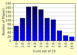
Avg Score
5 / 10
Plays
4117
- -
Question 1 of 10
1. The world's original landmass, from which today's continents and other major landmasses emerged, was called Pangaea. What, however, was the name of the world's first ocean? Hint


Question 2 of 10
2. Which mountain range extends for more than 100 miles into England from the Scottish border? Hint


Question 3 of 10
3. The Effigy Mounds National Monument is home to prehistoric indian sculptures. The Indians molded mounds into the shape of animals. Where is this monument located? Hint


Question 4 of 10
4. The Running of the Bulls occurs every year in the city of Pamplona in Spain as a part of the Los Sanfermines, a festival. In what Spanish region, however, is the city of Pamplona? Hint


Question 5 of 10
5. The highest navigable lake in the world is Lake Titicaca. Between which two countries does it lie?

Answer: (Two Words .. no need to included "and" )
Question 6 of 10
6. Oil is transported out of the Persian Gulf along what strait? Hint


Question 7 of 10
7. Romania is a small European country surrounded by five other nations. Four of these countries include Serbia, Ukraine, Hungary and Bulgaria. What is the missing fifth country? Hint


Question 8 of 10
8. The oldest hereditary monarchy in the world resides in Japan. What is the symbol for the Japanese monarchy? Hint


Question 9 of 10
9. Every year outside of Riyadh the Jenadriyah Camel Race occurs, an effort to preserve a part of what country's heritage? Hint


Question 10 of 10
10. The Russian space-launch facility, the Baikonur Cosmodrome is situated by the Aral Sea. What country is it in? Hint


(Optional) Create a Free FunTrivia ID to save the points you are about to earn:

arrow Select a User ID:
arrow Choose a Password:
arrow Your Email:


Most Recent Scores
Aug 24 2024 : 1995Tarpon: 2/10
Jul 21 2024 : Guest 136: 3/10

Score Distribution

quiz
Quiz Answer Key and Fun Facts
1. The world's original landmass, from which today's continents and other major landmasses emerged, was called Pangaea. What, however, was the name of the world's first ocean?

Answer: Panthalassa

The word Pangaea actually derives from the Greek word 'pangaia', which translates roughly as 'all earth'). The concept was created by a meteorologist, Alfred Wegener (German) in 1912. Basically, today's continents were all grouped together into one large supercontinent, Pangaea.

This landmass has been said to have covered either approximately one-quarter or one-half of the Earth's surface and stretched in a narrow belt of about 60 degrees of longitude between the two poles. It consisted of a group of northern continents, collectively called Laurasia, and a group of southern continents, collectively called Gondwana. Pangaea was surrounded by Panthalassa, an enormous ocean which extended to approximately twice the width of today's Pacific Ocean at the equator and reached both of the poles. During the end of the Triassic Period (245 to 208 million years ago), the landmass began to split into its segments of Laurasia (which contained all of today's northern continents) and Gondwanaland (which contained all of today's southern continents).

The split resulted in the early Atlantic Ocean. The Panthalassa was not simply a huge body of water surrounding Pangaea, however, it also contained numerous islands, volcanic archipelagoes and other areas such as reefs. Part of it even extended deep into Pangaea roughly where today's present Mediterranean Sea lies. It was called the Tethys.
2. Which mountain range extends for more than 100 miles into England from the Scottish border?

Answer: The Pennines

The Pennines are the mountains that form the 'spine' of Northern England and reach from the Scottish border in Northumberland down into the edges of Derbyshire. On either side of the backbone, numerous well-known rocky and hilly areas are located, gently sloping down to the coastlines on the east and west coasts of England.

These include the moors, vales and mountains of Yorkshire, Lancashire, the Lake District, the Peak District, the Tyne region and Cheshire. The Pennines are actually crossed repeatedly by extensions of these outlying areas, with the effect that the Pennines do not actually reach in an one unbroken chain, but continue in a series of disjointed groupings.

The Northern end of the Pennines is the more elevated section. The Pennines are also home to Hadrian's Wall at the northern end, a Roman barrier built by Emperor Hadrian to contain the Celts living in modern-day Scotland and to act as a line of defence.
3. The Effigy Mounds National Monument is home to prehistoric indian sculptures. The Indians molded mounds into the shape of animals. Where is this monument located?

Answer: Iowa

The Effigy Mounds National Park is located on the banks of the Mississippi River in northeastern Iowa, U.S.. The Park was set up in 1949 and contains 183 mounds. Most of these are shaped in the form of birds and bears. Some of the mounds date back as far as 2,500 years old, but the effigy mounds were built later. Excavation of the mounds has revealed bone and stone tools. Such animal effigy mounds are not, however, restricted to this one location and many have been found throughout the north-central United States, although not in the same abundance as at the Effigy Mounds National Park. Outside of the Park, the effigies have also consisted of deer, turtles, and buffalo.

The largest mound is that of a snake in southern Ohio, which is 1,300 feet long (about 400m).

The largest bird effigy is near Madison, Wisconsin, which has a wingspan of 624 feet (190 metres). In addition to the effigy mounds, thousands of Indian burial mounds are scattered around the eastern portion of the lands along the Mississippi River.

Not much, however, is known about the culture or the tradition that sculpted the effigy mounds. Interestingly, although many of the effigy mounds are burial sites, there are also ones that are not, but no one has been able to determine their significance. All that is known is that the Effigy Mound culture existed between AD 300 to the mid-1600s.
4. The Running of the Bulls occurs every year in the city of Pamplona in Spain as a part of the Los Sanfermines, a festival. In what Spanish region, however, is the city of Pamplona?

Answer: Navarre

Pamplona is actually the capital of Navarra provincia (Navarre), which is an autonomous community in northeastern Spain. It is extremely close to the French border, near to Bayonne. It had a fairly hard-fought struggle throughout its existence, being founded in 75BC as a Roman military establishment to put down a revolt against Rome by Quintus Sertorius.

It was then badly damaged over the course of numerous Moorish and Frankish invasions in the early part of the first millenia, culminating with Charlemagne's attacks in the late 770's. Sancho III of Navarre (1000-35) settled the city down as the capital of his new kingdom of Navarre. King Ferdinand of Aragon-Castile took the city in 1512 and relegated it to a princedom.

Henri of Navarre played an important role in the French experience of the Reformation in the mid-16th Century (see my Reformation quiz for more information).

The Navarre kingdom was finally incorporated into Spain proper in 1841. The Fiesta de San Fermin starts on July 6 and lasts until the 14th.

It is in honour of the city's first bishop, St. Fermin, and was made infamous by its description in 'The Sun Also Rises', written by Hemingway in 1926. The running of the bulls occurs every morning throughout this period and is the precursor to the daily bullfights.
5. The highest navigable lake in the world is Lake Titicaca. Between which two countries does it lie?

Answer: Peru Bolivia

Lake Titicaca (translating as alternatively the Rock of the Puma or the Crag of Lead), which lies at 12,500 feet above sea level (approximately 3,810m), is the highest navigable lake for large vessels and the second largest in South America. Peru is on the west and Bolivia on the east.

Although it is actually separated into two distinct bodies of water by a narrow strait, it is considered to be one lake (despite which, each smaller body has an individual name: Lake Huinaymarca (to Bolivians) or Lake Pequeno (to Peruvians) is the more southern lake and Lake Chucuito (to Bolivians) and Lake Grande (to Peruvians) is more northerly).

Its longest stretch on a north-south axis (actually northwest to southeast) is about 125 miles (approximately 200 km) and it is about 50 miles long (approximately 75 km) at its widest.

The deepest point is about 900 feet (275m). At its most northern aspect, some of the surrounding peaks reach as high as 21,000 feet (approximately 6,400 m). The Lake also boasts the second-highest railway in the world that runs down to Arequipa on the Pacific coast.

It is extremely important in that it is an economic lifeline for land-locked Bolivia. The Inca people (one of the oldest civilizations known in the Americas) inhabited the shores of the Lake and their ruins can still be found there. Indeed, the Lake had mythical qualities in Inca beliefs, the founders of the civilization were purportedly sent to Earth by the Sun at the southern end of the Lake.
6. Oil is transported out of the Persian Gulf along what strait?

Answer: Hormuz

The Strait of Hormuz (also called Strait Of Ormuz), which is quite wide ranging from about 30 to 60 miles wide (approximately 50 to 100km), links the Persian Gulf with the Arabian Sea via the Gulf of Oman. On the north side lies Iran and on the south the Arabian Peninsula.

It is of particular importance for the shipping of oil. The Port of Hormuz (in southern Iran) is perhaps one of the most significant ports in the area. The port was captured by the Portugese in 1514 under the control of Afonso de Albuquerque, a Portugese soldier determined to secure maritime trade routes for Portugal with the Far East.

He was also responsible for conquering Goa and Melaka (on the Malay Peninsula). His determination led to a number of Portugese forts along the Strait of Hormuz and for a long-lasting Portugese influence in the area.

The Island of Hormuz was one such place where the Portugese installed themselves, building a fort and not being ousted until 1622, when a joint force of English (who were gradually building their own empire) and Persian soldiers ousted the Portugese.

The Strait controlled completely any trade with China and India up until modern times.
7. Romania is a small European country surrounded by five other nations. Four of these countries include Serbia, Ukraine, Hungary and Bulgaria. What is the missing fifth country?

Answer: Moldova

Romania is the largest country on the Balkan Peninsula, with Ukraine on the north, Moldova on the northeast, the Black Sea on the east, Bulgaria on the south, Serbia on the southwest, and Hungary on the west. The capital city is Bucharest. The Romanian people originally had much in common with the ancient Greek civilization and were a substantial threat to that empire.

They also posed a threat to the Roman empire and fought long and hard against being subsumed by the Romans. This eventually occurred, however, around 106 AD. Since then, the Romanians have derived much of their ethnic and cultural character from that Roman influence, although their culture has been significantly altered by many cultures, as Romania lies upon some of the oldest migratory and trade routes known in Europe.

The country has a diverse environment being completely dominated by the Carpathian Mountains. Due to the presence of the Mountains, various areas of Romania often have flora, fauna and weather climates that range from one extreme to the other.
8. The oldest hereditary monarchy in the world resides in Japan. What is the symbol for the Japanese monarchy?

Answer: Chrysanthemum

The Japanese culture has been dominated by royal rule for almost as long as historical memory dates back in written accounts and accuracy. The first significant rulers were those of the Yamato era, when the Yamato ruler had control over the headmen of the most powerful uji (clans).

The role of ruler was passed down through family lineage. The ruler in turn sat over the Yamato court, whose members were drawn from the group of powerful clan leaders awarded kabane (titles). The two most important kabane were muraji and omi, which were given only to the clan leaders of the more powerful communities in and around in the area of the Yamato court.

Despite being assigned a lower-ranking title, if one was a leader of a smaller or more geographically distant clan, the Yamato Court gained quite devotional allegiance. Around the same time in the early Fifth Century BC, occupational groups, called be or tomo arose and provided significant support to the Court or its major supporting Uji.

These groups specialized in providing economic or military support.

Despite numerous set backs and political upheaval (one really should read some Japanese history, it is truly intriguing and more TV soap like than anything you might actually see on TV), the monarchy grew and has been in place (although with certain dynastic changes) since that time. The chrysanthemum has been the royal symbol for a long time and has even had an Order evolve from it, the Dai-kun-i Kikka-sho Kubikazari. It is now Japan's highest and most exclusive order. The Order of the chrysanthemum was established in 1877 by the Meiji emperor and has been only awarded to male members of the royal family and to foreign royalty or heads of state.
9. Every year outside of Riyadh the Jenadriyah Camel Race occurs, an effort to preserve a part of what country's heritage?

Answer: Saudi Arabia

Riyadh is the capital city of Saudi Arabia and is located on the central Arabian Peninsula. It was chosen to be the capital of the Sa'ud dynasty in 1824. The Sa'ud dynasty was the strongest sheikdom prior to the formation of the Unified Kingdom of Saudia Arabia, and so when this occurred in 1932, Riyadh was chosen as the new country's capital city.

It is the commercial heart of the oil-strong nation. Just outside of Riyadh, an annual festival is staged, called the Jenadriyah Heritage and Cultural Festival, which has been strongly supported in an effort to preserve the nation's national heritage and traditions.

It is organized by the National Guard, which is in turn commanded by the Crown Prince. Although the festival contains many sights, such as music, entertainers and so on, the big draw is the camel race that always opens the festival.
10. The Russian space-launch facility, the Baikonur Cosmodrome is situated by the Aral Sea. What country is it in?

Answer: Kazakhstan

The Cosmodrome was Soviet in origin, but has continued to be operational under its current Russian control. Baikonur was actually a Soviet codename assigned to the space centre, but it was called Tyuratam by the Americans, after the nearby railway station in Leninsk, the biggest local city.

The space station was the principal space station throughout the 1960's up to the 1980's (it was originally built in the 1950's as a missile centre) and was the site where a number of historic events occurred.

The first artificial satellite was sent into orbit in 1957, Yuri Gagarin was the first man in space after taking off from Baikonur in 1961 and Valentina Tereshkova left there to become the first woman in space in 1963. It has been maintained as a space station by the Russians since the collapse of the Soviet Union in 1991. Kazakstan is actually an autonomous country, however, bordered on the northwest and north by Russia, on the east by China, and on the south by Kyrgyzstan, Uzbekistan, Turkmenistan, and the Aral Sea.

Its southwestern border is the Caspian Sea. It is the largest state in Central Asia and is the ninth largest country in the world. The capital city is Astana.
Source: Author TemplarLLM

This quiz was reviewed by FunTrivia editor spanishliz before going online.
Any errors found in FunTrivia content are routinely corrected through our feedback system.
9/9/2024, Copyright 2024 FunTrivia, Inc. - Report an Error / Contact Us