Answer: Yellow Sea
The peninsula has 8640 kilometers of coastline bordered by the Yellow Sea to the west, the Sea of Japan to the east, while to the south is the East China Sea. The Korean Strait connects the Yellow Sea and the Sea of Japan. The peninsula is bordered by two rivers separating it from China and Russia.
Red Crew's smpdit splashes in the paddling pool as she writes this question.
From Quiz: Exploring The Korean Peninsula
Answer: China and Russia
Located in East Asia, the Korean Peninsula extends for about 1,100 km (680 mi) into the Pacific Ocean. The peninsula has land borders with China in the northwest (Liaoning and Jilin provinces) and Russia to the northeast (Primorsky Krai). The border with China is by far the longest of the two - 1,416 km (880 mi) - while the Russian border is a mere 17.5 km (10.9 mi). These borders touch North Korea, the larger of the two sovereign states that occupy the peninsula, while South Korea only borders its northern neighbour. The two states also share a maritime border with Japan to the east.
LadyNym hopes this question will be more than just borderline acceptable.
From Quiz: Korea, Geographically
Answer: Jejudo
This spectacular island which lies off the west coast of Korea is a delight. Many young couples make this a honeymoon destination. The scenery is magnificent and the waterfalls are breathtaking.
From Quiz: Islands of South Korea
Answer: Green
Just like the London Underground system, each line has a different colour. Line 5 is purple, line 4 is blue, and pink is the colour of line 8.
From Quiz: Seoul Subway, South Korea
Answer: 25
Seoul is divided into 25 'gus' which are Jongro, Jung, Yongsan, Seongdong, Mapo, Seodaemun, Dongdaemun, Eunpyoung, Gangbuk, Seongbuk, Dobong, Nowon, Jungrang, Gwangjin, Gangdong, Songpa, Gangnam, Seocho, Gwanak, Dongjak, Youngdeungpo, Geumcheon, Guro, Yangcheon, and Gangsuh
From Quiz: Korean Geography
Answer: Kim Young-sam and Kim Jong-pil
These three have battled it out on the Korean political scene for decades, and two of them (Kim Young-sam and Kim Dae-jung) have served as the country's President. With Kim Dae-jung's presidency drawing to a close at the time of writing (2002), it is still an open question who will inherit their positions at the top of Korean movers and shakers.
From Quiz: Korea
Answer: Rabbit
The ears of the bunny touch Siberia, while Cheju island is considered the misplaced cottontail...cute huh? Korean scholars have also compared the shape of the country to a tiger.
From Quiz: Korean Geography
Answer: T'aekwondo
T'aekwondo has a national membership of over 3.5 million and the World Federation is located in Seoul. It became a fully recognised sport at the 2000 Olympic Games. Ssirum is a form of wrestling that has been popular in Korea since the Three Kingdoms period (57 BC - 668 AD). In most contests the winner receives a large bull.
From Quiz: Korean Kulture
Answer: Laos
The Korean Peninsula, home to the Democratic People's Republic of Korea (North Korea) and the Republic of Korea (South Korea), is 223,170 km˛ (86,166 mi˛) in size. Of these two countries, North Korea (120,540 km˛/46,540 mi˛) is larger than South Korea (100,363 km˛/38,750 mi˛). Included in the figures for the Korean Peninsula is the Demilitarized Zone between these two countries.
While Asia has 12 landlocked countries, the only one in the answers is Laos. This socialist country in the Indochinese Peninsula is the 82nd largest country at 237,955 km˛ (91,875 mi˛).
In decreasing order of size, the areas of the other answer countries are:
Thailand, 50th, 513,120 km˛ (198,120 mi˛);
Vietnam, 66th, 331,699 km˛ (128,070 mi˛);
Cambodia, 88th, 181,035 km˛ (69,898 mi˛).
Phoenix Rising's psnz struggled to fit this question into the quiz.
From Quiz: Korea, Geographically
Answer: Jebudo
Jebudo is a somewhat small island that sits west of Suweon and belongs to Hwaseong. One of the distinctive features of this island is that its connection to the mainland disappears with the high tide. As the tide lowers, the connecting road is revealed. Hence, the term "Miracle of Moses."
From Quiz: Islands of South Korea
Answer: West
Although North Korea is situated on a peninsula, there are only two coastlines: one on the west, one on the east side. To the south lies South Korea (evidently), and to the north there are land borders with China and Russia. Pyongyang lies near the western coast, near the Yellow Sea. The Taedong River connects it with the sea. Famous landmarks include the Juche Tower (completed in 1982, as a political statement), the Arch of Triumph and the Arch of Reunification. The tallest building is the Ryugyong Hotel ("Willow Hotel"), with 105 floors.
From Quiz: North Korea: A Basic Quiz
Answer: Anyang-Haseyo
Both "Anyang-Keseyo" and "Anyangi-Kaseyo" are ways of saying "Goodbye" (one is for as you are leaving, the other for someone who is leaving). The word "Anyang" is a familiar way to say either "Hello" or "Goodbye."
From Quiz: Trivia Potpourri (South Korea)
Answer: Incheon
Incheon is the correct answer here, Bucheon and Suwon are not considered "gwangyokshi" because they have a population less than 1 million people, and Daejeon is a metropolis but it's about a hundred kilometres south of Seoul.
From Quiz: Korean Geography
Answer: Busan
Busan was formerly known as Pusan before the Latinisation changes introduced by the South Korean government. Busan is currently recovering from the effect of Typhoon Rusa which wrecked several facilities for the Games.
From Quiz: Korea
Answer: Tumen
The Yalu was made famous to Americans when American troops pushed the North Koreans to that boundary (Yalu) between Korea and China during the early stages of the Korean War. Macarthur considered crossing the river into China, but Truman would have none of it. Hundreds of thousands of Chinese troops made their way across the frozen Yalu to fight and die during that war. The Tumen makes up part of the boundary between Korea and China, and all of the short boundary between Korea and Russia.
From Quiz: Korean Geography
Answer: 50 %
Only five percent of the population is over 65!
From Quiz: South Korea
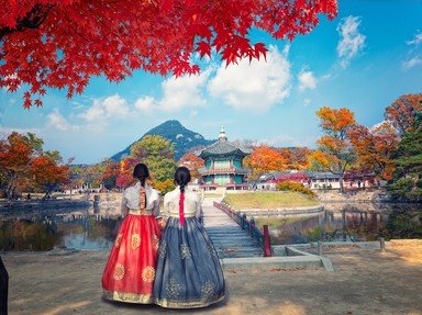
Answer: hanbok
The man's basic outfit consists of a chogori (jacket), paji (trousers) and turumaji (overcoat). The jacket has loose sleeves and the trousers are roomy and tied with straps at the ankles. Women also have a chogori with two long ribbons tied to form the otkorum (bow) and has long full sleeves and a full lenth, high waisted wraparound skirt called the chima. White cotton socks with boat shaped shoes of silk, straw or rubber are worn as well.
From Quiz: Korean Kulture
Answer: Nakdong
The Nakdong River, also called the Nakdonggang River, is the longest river in Korea. Despite a long history involving wars, phenol contamination and overdevelopment, there are still significant wetlands on the floodplains. The Joonam reservoirs in particular are home to many rare and threatened species of birds, fish and plants. The Nakdong and its tributaries also provide much of the river basin's drinking water, however domestic and agricultural wastewater has caused local water pollution.
Phoenix Rising's Red Crew member leith90 paddled this question strait into the quiz.
From Quiz: Exploring The Korean Peninsula
Answer: Dokdo
Historically, the islands also bear the name of Liancourt Rocks. South Korea maintains a Coast Guard station on the islands. Arguably, the nature of the territorial dispute arises from the rich fishing preserves in the surrounding waters.
From Quiz: Islands of South Korea
Answer: White Mountain
The Japanese word "-san" is generally translated to "holy". "Venerable" would fit better, but for shortness most English speaking people use the word "holy".
But Korean is not Japanese. The Korean word "san" means "mountain".
You know now what the "-san" part means, but what is the Baekdu part? Well, most of the options I gave were figments of my imagination. As far as I know, there is no Korean Mountain of the Holy Ancestors - this red herring refers simply to a wide-spread practice in island nations in the Pacific Ocean. The Smoky Mountains are in the USA, not in North Korea. There is no such thing as a Mountain of Youth. During the 16th and early 17th centuries, some explorers tried to locate a Fountain of Youth in South America.
From Quiz: North Korea: A Basic Quiz
Answer: Boccherini's Minuet in E
This is the most frustrating thing about the system, and it always happens to me! Moreover, "Fur Elise" seems to be the ringtone on every doorbell in this country!
From Quiz: Seoul Subway, South Korea
Answer: 4
Yes, the number 4 is South Korea's unlucky number. I learned this one night, at a hotel in Ouijongbu. It was a four-story building, but the elevator buttons were labelled 1, 2, 3, and 5 (much like the number 13 is skipped within buildings in the U.S.).
From Quiz: Trivia Potpourri (South Korea)
Answer: Mt. Baekdu (Paekdu)
Mt. Baekdu (Paekdu) is located in North Korea's Yanggang province and it is 2744m above sea level. The peak and the surrounding territory is shared with China.
From Quiz: Korean Geography
Answer: Kaesong
Unlike the North Korean "settlement" nearest to the DMZ, Kaesong is a real, populated city, which you can see on a clear day from the observation deck in the South Korean side of the DMZ. Dandong is in China.
From Quiz: Korea
Answer: China
This may come as a surprise to many. There are approximately 1.8 million Koreans in China, 1 million in the
United States and 700,000 in Japan. The Koreans claim that the ancient Koguryo kingdom extended well into territory now claimed by China.
From Quiz: Traditional and Modern Korea
Answer: 1980
The people were protesting the assumption of power by General Chun Doo Hwan.
From Quiz: South Korea
Answer: 81,340
The entire Korean Tripitaka was carved twice during the Koryo Dynasty (918-1392), on wooden blocks. The carving of the first set of blocks was completed in 1087. However, it was burnt in the invasion of the Mongolians in 1232. In 1236, King Kojong (r. 1213-1259) ordered them to be recarved. Sixteen years later, the present-day Korean Tripitaka was produced in 1251. The blocks were made from white birch trees and were wholly submerged in seawater for three years, then cut into planks and boiled in seawater before being dried in the shade. The logs were smoothed and the letters were painted on before being carved. There are 52,382,960 characters which were carved by 30 people, each character being carved after bowing to the Buddha. There is not a single mistake in the entire collection. It is on the UNESCO World Heritage List.
From Quiz: Korean Kulture
Answer: Paektu
Paektu mountain, (also called Baekdu), or Changabai in China, is the highest peak in both North or South Korea. With an elevation of 2744m, it is referred to as the spiritual home of both countries, and is also depicted on the national emblem of North Korea. Mount Paektu is a strata-volcano which last erupted in 1903. Inside the caldera is a lake called Heavenly Lake, formed when the volcano explosively erupted in 946. Earthquakes from 2002 to 2005 had seismologists concerned of an impending eruption, but it has since remained dormant.
Phoenix Rising's Red Crew member leith90 has been inside a dormant volcano's caldera and has crossed it off her bucket list.
From Quiz: Exploring The Korean Peninsula
Answer: Ulleungdo
It is often suggested that Ulleungdo possesses five positive characteristics. That is, strong winds, pure water, beautiful residents, lots of rocks and juniper trees. The South Korean government has been trying to promote tourism of the island.
From Quiz: Islands of South Korea
Answer: The Amnok River
The border between China and North Korea is for the most part formed by the Amnok River, which the Chinese call the Yalu River. It is very shallow (about three metres), but provides nevertheless great fishing opportunities for small vessels.
During the Korean War most of the bridges crossing the Amnok River were destroyed. The only bridge that survived the war was the Sino-Korean Friendship Bridge, built in 1943.
The Huang Ho River (Yellow River) is situated in China, and the Mekong River runs through China, Myanmar, Thailand, Laos and Cambodia. The Amur River forms part of the frontier between Russia and China.
From Quiz: North Korea: A Basic Quiz
Answer: 1970
In 1950, the Korean War had just started-redevelopment was a long way off.
From Quiz: Seoul Subway, South Korea
Answer: KATUSA
From Quiz: Trivia Potpourri (South Korea)
Answer: Marado (island)
Marado is the most southern point in Korea (33N 06' 40"). Jeju is near but not the southern most, Uleung is east and Ddangkkeut Maeul is the most southern point on the mainland
From Quiz: Korean Geography
Answer: Tangun
Tangun is said to have been born at Mount Taebaek in what is now North Korea. According to legend, his mother was a bear who had assumed human form after being instructed to fast in a cave for 100 days.
Queen Min was the "last empress" of Korea, assassinated by Japanese agents in 1895 and now the subject of a successful musical.
Yi Sun-shin is one of Korea's greatest heroes, a naval admiral famed for his defeats of the Japanese.
Chosun is the name of an ancient dynasty of Korea; it is also the name used by North Korea for "Korea" (the South uses "Hanguk").
From Quiz: Korea
Answer: Chokpo
In Korea, the family
genealogy is of the utmost importance. This relates to the Confucian tradition, imported
from China. South Korea may in fact be the most Confucian of any nation today, very
carefully retaining the essential genealogy records required for ancestor worship.
From Quiz: Traditional and Modern Korea
Answer: Mt. Paektu
The name 'Paektu' means 'white head' in Korean. The Chinese call it 'Changpai shan' or 'ever-white mountain'. It rises 9,003 ft. (2744 m.) above sea level and sits at the border between North Korea and China. Mt. Halla is the highest mountain in South Korea, at 6,398 ft. (1950 m.).
From Quiz: Korean Geography
Answer: 1500
The mountain system (more than one range is involved) is never crossed by a body of water but contains the headwaters of many rivers. It is significant in many native religions as the source of life. The South Korean section is about 735 km and the crest trail is a pilgrimage/hiking trail; enthusiasts hope the North Korea portion will some day be linked for hiking. The tallest mountain in North Korea, Paektu, is at the northern end of the system - it is 2743m or 8999 ft high. The second highest mountain which is in South Korea, Jirisan, is at the southern terminus. It is 1915m (6283 ft); the tallest mountain in South Korea is on Jeju Island and is not part of Baekdu-Daegan.
Player pusdoc climbed through a lot of information to write this question for Phoenix Rising's Red Crew.
From Quiz: Exploring The Korean Peninsula
Answer: islands
In the Korean language, "do" means "island". The three listed are the largest of more than three and a half thousand Korean islands. The vast majority of these lie off the southern and western coasts of the Korean Peninsula.
Jeju Island (Jeju-do) is South Korea's largest and most-populous island with an area of 1,833 km˛ (708 mi˛). In 2020, the population numbered about 670,000 persons. Jeju Island lies in the Korea Strait (see Q. 3), which is south of the mainland of the Korean Peninsula. It is 83 km (51 mi) offshore and, like many Korean islands, is of volcanic origin. The island serves as a popular holiday destination.
Geoje Island, also in the Korea Strait, is the second largest island in South Korea (383 km˛/148 mi˛), and is connected to the mainland by two bridges. Jindo is South Korea's third largest island (363 km /140 mi˛), also with bridge access to the mainland. The Korean Jindo dog is native to this island.
Phoenix Rising's psnz charted this question for the quiz.
From Quiz: Korea, Geographically
Answer: Multiple-use subway ticket
These cost 10,000 won (about five English pounds) and are one of the cheapest forms of travel in this wonderful country!
From Quiz: Seoul Subway, South Korea
Answer: Daewoo
The Daewoo Le Mans was virtually identical to its Pontiac counterpart. The only obvious differences were that the arrowhead was gold on the Daewoo model (Pontiac's was red), and that it had daytime running lamps (a feature not seen in America until the mid-1990s).
From Quiz: Trivia Potpourri (South Korea)