FREE! Click here to Join FunTrivia. Thousands of games, quizzes, and lots more!
Quiz about A Look at Louisiana

A Look at Louisiana Trivia Quiz


How much do you know about Louisiana? Put on a pair of hip boots, because that's where we're heading in this quiz. From sprawling swamps and cypress trees to historic outposts and shrimp capital(s) of the world, I give you the Pelican State. Have fun!

A photo quiz by NeuralSpicy. Estimated time: 3 mins.
  1. Home
  2. »
  3. Quizzes
  4. »
  5. Geography Trivia
  6. »
  7. States F-L
  8. »
  9. Louisiana

Author
NeuralSpicy
Time
3 mins
Type
Photo Quiz
Quiz #
426,007
Updated
Oct 26 26
# Qns
10
Difficulty
Easy
Avg Score
8 / 10
Plays
49
Last 3 plays: lethisen250582 (10/10), Guest 70 (3/10), Guest 104 (8/10).
-
Question 1 of 10
1. What major river forms much of Louisiana's boundary with its eastern neighbor? Hint


Question 2 of 10
2. Which Louisiana site became a UNESCO World Heritage Site because of its ancient Native American earthworks? Hint


Question 3 of 10
3. What is the highest point in Louisiana? Hint


Question 4 of 10
4. Which Louisiana city is located at the point where the Red River meets the Cane River region and is known as the oldest permanent settlement in the Louisiana Purchase? Hint


Question 5 of 10
5. Which body of water lies directly south of Louisiana? Hint


Question 6 of 10
6. What is the name of the large inland lake in southeastern Louisiana connected to the Gulf through Lake Borgne? Hint


Question 7 of 10
7. What is the term for the fingerlike landforms created where the Mississippi River deposits sediment into the Gulf? Hint


Question 8 of 10
8. Which historic site in northwestern Louisiana once served as the capital of the Spanish province of Texas? Hint


Question 9 of 10
9. Which region in Louisiana is famous for its extensive bottomland hardwood forest and concentration of bald cypress trees? Hint


Question 10 of 10
10. What Louisiana town sits along Bayou Carlin and is often called the "Shrimp Capital of the World", a claim disputed by Morgan City? Hint


(Optional) Create a Free FunTrivia ID to save the points you are about to earn:

arrow Select a User ID:
arrow Choose a Password:
arrow Your Email:


View Image Attributions for This Quiz

Most Recent Scores
Today : lethisen250582: 10/10
Today : Guest 70: 3/10
Today : Guest 104: 8/10
Today : Guest 99: 9/10
Today : Guest 75: 10/10
Today : Guest 24: 10/10
Today : Dreessen: 7/10
Today : Flukey: 9/10
Today : Guest 50: 9/10

Quiz Answer Key and Fun Facts
1. What major river forms much of Louisiana's boundary with its eastern neighbor?

Answer: Mississippi River

The Mississippi River cuts through the middle of the United States like the scar running down a boxer's face. By the time the scar reaches Louisiana, it has already traveled more than 2,300 miles (3,700 km) from its humble origins in northern Minnesota. The river forms a large part of the border with Mississippi, which is the state's eastern neighbor.

The river has been Louisiana's lifeblood for centuries. That overly broad brown current has carried cotton, timber, jazz musicians, riverboat gamblers, as well as slaves and Civil War gunboats. Cities like Baton Rouge and New Orleans grew up around it and thrived because of it.
2. Which Louisiana site became a UNESCO World Heritage Site because of its ancient Native American earthworks?

Answer: Poverty Point

Poverty Point, which you'll find in northeastern Louisiana, looks unreal from above. Giant ridges curve across the land in huge concentric arcs like an amphitheater. It was built by Native Americans more than 3,000 years ago with baskets full of earth and a whole lot of determination. No horses or wheeled carts. Just people hauling dirt around by hand.

In 2014, UNESCO added it to its World Heritage list as a globally important cultural site.
3. What is the highest point in Louisiana?

Answer: Driskill Mountain

Driskill Mountain, the highest point in Louisiana, towers above the surrounding landscape, boasting a breathtaking peak elevation of about 535 feet (163 meters) above sea level. Okay, that's pretty modest, but in fairness, this is one U.S. state that features points BELOW sea level.

Driskill is a fabulous challenge if you have trouble with short flights of stairs. You'll find it tucked into northern Louisiana near the town of Bryceland. The hill has wooded trails and plenty of pine shade, making it feel removed from the swampy image most people have of the state. And upon completing the climb, with your heart racing at about 75 beats per minute, you can look out and see precisely that swampy image most people have of the state.
4. Which Louisiana city is located at the point where the Red River meets the Cane River region and is known as the oldest permanent settlement in the Louisiana Purchase?

Answer: Natchitoches

Natchitoches is supposedly pronounced "NACK-uh-tish", but a lot of natives on the internet seem to consider certain syllables optional. It really doesn't matter, though. You're not going to understand much of anything they say there anyway. We're in Creole country.

But we're talking about the city. Natchitoches has been alive and kicking since 1714. It was founded by the French as a trading outpost, which makes it the oldest permanent settlement in the entire territory of the Louisiana Purchase. The city grew up along the Red River and the nearby Cane River area, where French and Spanish settlers, Africans, and Native Americans contributed to a Creole culture that shaped the region's architecture and its puzzling dialect. Brick streets, wrought-iron balconies, and old plantation homes all conspire to give parts of town the atmosphere of a historical novel. Just not one written in English.
5. Which body of water lies directly south of Louisiana?

Answer: Gulf of Mexico

The Gulf of Mexico has shaped nearly everything about life in Louisiana. The food, weather, economy, as well as the sights and sounds of the southern parts of the state. Shrimp boats head out before dawn. Pelicans do their thing. Hurricane forecasts are much more than a curiosity.

The coastline is also fringed with marshes and bayous where freshwater from the Mississippi River mixes with salty Gulf waters to create that whole much-celebrated muddy muddle we call Louisiana.
6. What is the name of the large inland lake in southeastern Louisiana connected to the Gulf through Lake Borgne?

Answer: Lake Pontchartrain

Lake Pontchartrain dominates southeastern Louisiana like a shallow inland sea, covering more than 600 square miles (1,554 square kilometers) just north of New Orleans. Not that the people who named it care all that much, but it is technically an estuary because it connects to the Gulf of Mexico through Lake Borgne and exchanges salty water with the surrounding coastal system. So it's a lake with estuary street-cred, but whatever you call it, it's famous for the Lake Pontchartrain Causeway, a pair of bridges so long that a driver can start to feel a little like a sailor out in open waters.
7. What is the term for the fingerlike landforms created where the Mississippi River deposits sediment into the Gulf?

Answer: Bird-foot delta

The Mississippi River is big, sloppy, and very wet, even when viewed from space as in the image above. When it reaches the Gulf of Mexico, it doesn't give up quietly. It splays outward into long narrow channels, forming deposits which - if you squint your eyes just right after a few drinks - resemble the toes of a giant bird track pressed into the land. I'm not being poetic. That's the reason geologists call it a bird-foot delta. Personally, I would call it more arborescent in appearance (dendroid, if I were feeling especially mischievous), but then that's why I don't get invited to the cool parties.
8. Which historic site in northwestern Louisiana once served as the capital of the Spanish province of Texas?

Answer: Los Adaes Historic Site

You'll find Los Adaes Historic Site tucked in the pine forests near present-day Robeline, but during the 1700s it was caught up in some serious drama involving Spain, France, trade routes, and border disputes. From 1729 to 1770, Los Adaes served as the capital of Spanish Texas, even though it was located in what is now Louisiana. Spain planted the colony there to discourage French expansion into Texas and keep an eye on the nearby French settlement at Natchitoches.

Life at Los Adaes was hard and strongly connected to local Native American communities, especially the Adaes people for whom the site was named. Smuggling and unofficial trade with the French became commonplace because the settlement was so isolated from the rest of Spanish Texas. Eventually Spain gave up the capital and shifted operations westward to San Antonio.
9. Which region in Louisiana is famous for its extensive bottomland hardwood forest and concentration of bald cypress trees?

Answer: Atchafalaya Basin

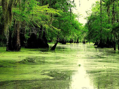
The waters of Atchafalaya Basin have been plotting against dry land for centuries. Spreading across south-central Louisiana, it is the largest river swamp and wetland system in the United States, packed with hardwood forests, sloppy bayous, and great big bald cypress trees draped in Spanish moss. Some of those cypress trunks flare outward at the base like buttresses sunk into the black water. During flood season, the whole landscape dissolves into an endless maze of trees and reflections.

The basin supports a range of wildlife, including alligators, crawfish, herons, black bears, and of course lots of fish. It also plays a major role in Louisiana's culture and economy. Crawfishing, fishing camps, swamp tours, and Cajun communities circle the basin like orbiting bodies.
10. What Louisiana town sits along Bayou Carlin and is often called the "Shrimp Capital of the World", a claim disputed by Morgan City?

Answer: Delcambre

Delcambre is a small town that identifies as a seafood restaurant. The town is nestled along Bayou Carlin, also known as the Delcambre Canal, which links Lake Peigneur to Vermilion Bay and the Gulf. It became famous for its shrimping industry and wears the title "Shrimp Capital of the World" with pride. (Morgan City also claims the title. I'll let them fight it out.)

For generations, shrimp boats have rolled out before sunrise while docks were abuzz with ice trucks, nets, and roaring engines. Around harvest season, the whole place becomes one giant kitchen surrounded by canals, farms, and of course, swamp.

We mustn't neglect to mention that the town also hosts the Delcambre Shrimp Festival, where locals celebrate the industry with parades, music, and enough fried seafood to send a healthy person to the hospital.
Source: Author NeuralSpicy

This quiz was reviewed by FunTrivia editor agony before going online.
Any errors found in FunTrivia content are routinely corrected through our feedback system.
10/26/2026, Copyright 2026 FunTrivia, Inc. - Report an Error / Contact Us