FREE! Click here to Join FunTrivia. Thousands of games, quizzes, and lots more!
Quiz about A River Running By

A River Running By Trivia Quiz

or a Lake, or a Sea, or Another Body of Water

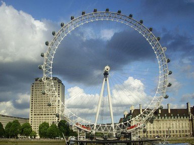
All these structures in the United Kingdom are close to a body of water, but which one? Can you match them up? For example the title picture shows the Ferris wheel known as the London Eye, so the water would be the River Thames.

by Lottie1001. Estimated time: 3 mins.
  1. Home
  2. »
  3. Quizzes
  4. »
  5. Geography Trivia
  6. »
  7. United Kingdom
  8. »
  9. UK Bodies of Water

Author
Lottie1001
Time
3 mins
Type
Quiz #
424,904
Updated
Aug 25 26
# Qns
12
Difficulty
Average
Avg Score
8 / 12
Plays
21
Last 3 plays: Trish192 (8/12), sarryman (7/12), james1947 (12/12).
Drag-Drop or Click from Right
Options
Coventry Canal North Sea Firth of Forth Menai Strait Loch Ness Rutland Water River Mersey River Clyde River Severn English Channel Norfolk Broads Irish Sea


 View Image Attributions for This Quiz

Most Recent Scores
Today : Trish192: 8/12
Today : sarryman: 7/12
Today : james1947: 12/12
Today : Barca99: 9/12
Today : thomas1975: 8/12
Today : Isipingo: 12/12
Today : kstyle53: 12/12
Today : earthangel59: 12/12
Today : JanIQ: 1/12

Quiz Answer Key and Fun Facts
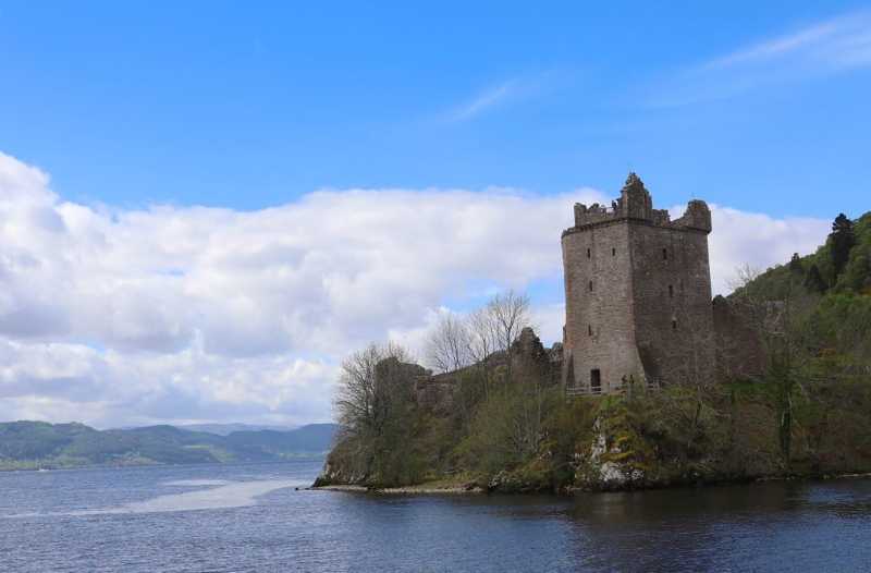
1. Loch Ness

The picture shows Urquhart Castle which is situated on the north shore of Loch Ness in the Highlands of Scotland. The first building took place in the thirteenth century, but Urquhart Castle has been in ruins since the seventeenth century.

The loch is one of the deepest in the country, and forms about a third of the Great Glen which runs for 100km from Fort William in the south-west to Inverness in the north-east. The loch's main claim to fame comes from the tales of a prehistoric monster which is thought to live in the murky depths of its waters.
2. Firth of Forth

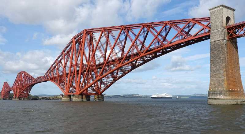
The picture shows the Forth Rail Bridge which was built at the end of the nineteenth century to carry rail traffic from Edinburgh towards Aberdeen. It is situated just north-west of Edinburgh and spans the mouth of the river Forth between North Queensferry and South Queensferry. Before its construction, the only way to cross the river was by ferry between those two points, or for trains to take a much longer route further west. The ferries continued to operate until the 1960s to cater for road traffic and pedestrians, but they fell out of use after the opening of a new road bridge in 1964.

Because of the need to protect the steel from the weather, it was painted regularly. It used to be thought that the painting took so long that it was necessary to start again at one end as soon as the other had been reached. With technical improvements to paints in the twenty-first century, repainting is not required so often, and the never-ending task of painting the Forth Bridge has come to an end.
3. River Clyde

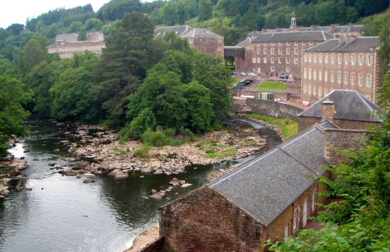
The picture shows New Lanark Mill. New Lanark is about 40km south-east of Glasgow. At the end of the eighteenth century a cotton mill was established there, making use of the water from the nearby River Clyde to power waterwheels to drive the machinery. In the early nineteenth century, under the direction of Robert Owen, the village was at the forefront of social welfare. Owen provided good housing and schools for the children, yet still managed to make a profit for the business.

The business closed in the 1960s, and some of the buildings fell into disrepair. Since then, the site has been taken over by a conservation trust. A hotel has been established in one of the former mill buildings. Others have been turned into a visitor centre and museum. Many of the houses have been refurbished for twenty-first century living. A hydro-electric power station has been built to make use of the water power from the nearby river.
4. North Sea

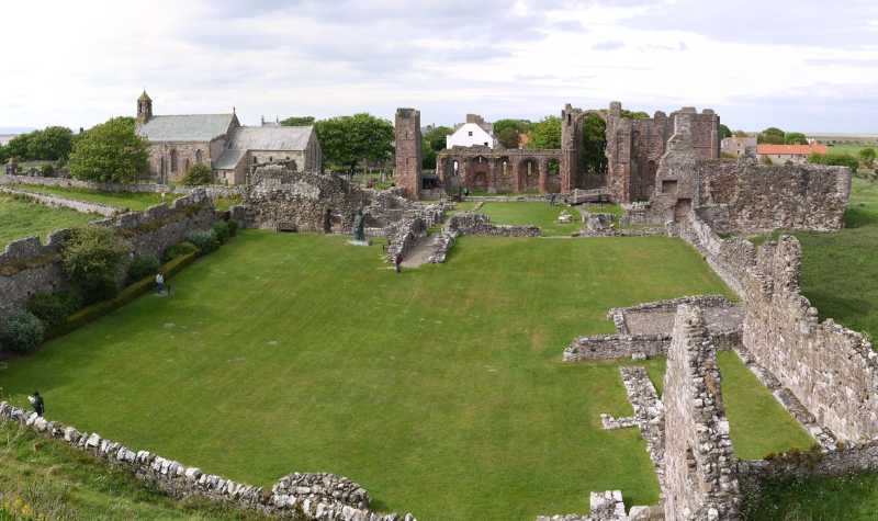
The picture shows Lindisfarne or Holy Island, which is situated just off the coast of Northumberland in northern England. Although it is called an island, there are times, during low tides, when it is possible to travel in a car or on foot across a causeway. It is a little less than 2km from the mainland to the island. However care needs to be taken, since bad weather can exacerbate the tides, meaning that the causeway may become impassable sooner than expected.

A monastery was first built on the island in the seventh century, when both St. Aidan and, later, St. Cuthbert were monks there. However it suffered under the Vikings at the end of the eighth century. The monastery was re-established by the Normans at the end of the eleventh century. Despite the final closure, during the reign of Henry VIII, the island has remained a destination for religious pilgrimages into the twenty-first century.
5. Irish Sea

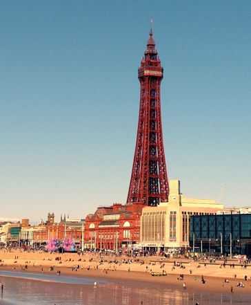
The picture shows Blackpool Tower, which was built at the end of the nineteenth century as a tourist attraction. The design was based on that of the Eiffel Tower in Paris. On completion, the tower, at 158m, was the tallest free-standing tower in the British Empire. It is situated on the seafront in the middle of the promenade and looks out across the Irish Sea towards the Isle of Man.

The base of Blackpool Tower is surrounded by a red-brick building which has at various times been home to an aquarium, a menagerie, a circus, an adventure playground, a bar, a roof-top garden, and a ballroom. On a clear day it is possible to sea the Isle of Man in the west, as well as the hills of North Wales to the south and the Lake District to the north. When the tower was first opened it cost sixpence for admission, another sixpence to ride in the lift to the top, and another sixpence to visit the circus. By the twenty-first century, it was still possible to do all of those things, but the price had increased somewhat.
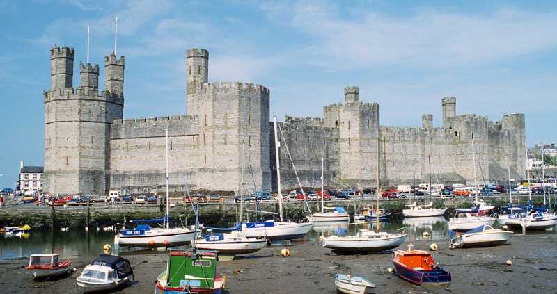
6. Menai Strait

The picture shows Caernarfon Castle, which was built on the north coast of Wales where the River Seiont joins the Menai Strait between the mainland and island of Anglesey. The first building was erected in the late eleventh century. Construction of the current stone building began at the end of the thirteenth century, when walls were also built to surround the town.

Edward I ordered its construction after defeating the Welsh and gaining control of the principality. His son, the future Edward II, was born in Caernarfon and presented to the people as the new Prince of Wales. Since then, that title has traditionally been given to the eldest son of a reigning monarch. In 1911, the Chancellor of the Exchequer, David Lloyd-George (a Welshman) persuaded King George V to hold a ceremony at the castle investing his son, the future Edward VIII, with the title of Prince of Wales. A similar ceremony was held there in 1969 when Queen Elizabeth II invested her son, the future King Charles III, as Prince of Wales.
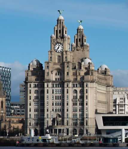
7. River Mersey

The picture shows the Royal Liver Building on the bank of the River Mersey in Liverpool. It was built for the Royal Liver Assurance company and opened in 1911. It is one of three buildings on the waterfront at Liverpool; the other two are the Port of Liverpool building from 1907 and the Cunard Building from 1916.

The Royal Liver Building is known for the two birds, one sitting on top of each of its two clock towers. The were the symbol of the company because of the name of the inn where the original friendly society, the Royal Liver Society, first met. A competition was held to choose a designer for them; it was won by Carl Bernard Bartels who had been born in Germany and learnt the skill of woodcarving from his father in the Black Forest. He had lived in London for over twenty years when he designed the birds. They are made from copper and 5.5m tall. One is female; she sits on the front tower and faces the water to watch for returning ships. The other, male, bird is on top of the rear tower; he watches the other way into the city to see when the pubs are open.
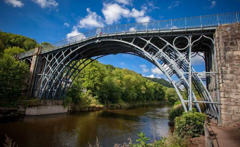
8. River Severn

The picture shows the iron bridge which was built across the gorge of the River Severn by Abraham Darby III at the end of the eighteenth century. His grandfather, also Abraham Darby, had developed the technique for smelting iron from coke in Coalbrookdale, about 1km away. This had been the catalyst for the industrial revolution, with many things being made from the relatively cheap iron including cooking pots, wheels, rails and boats.

The bridge built across the River Severn was the first in the world to be constructed from cast iron, and has lasted for well over two hundred years. It gave its name to the small town which grew up on the north side of the river beside the new structure, Ironbridge.
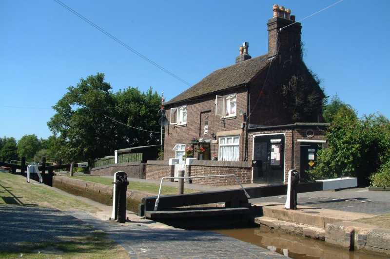
9. Coventry Canal

The picture shows the lock-keeper's cottage by the top lock of the Atherstone Locks on the Coventry canal. The Coventry Canal was built from Coventry to join the Trent and Mersey Canal to the north of Lichfield in central England. With a total of thirteen locks on the canal, eleven of them are designated as the Atherstone Locks. The top five are situated in a stretch of about 700m close to the small town of Atherstone. The remaining six are spaced out along the next 6km of the canal.

When the canals were built, it was necessary to choose whether to build a longer canal on a possibly slightly circuitous route that stayed at the same height, or to take a shorter route which required the construction of one or more locks to account for the gradient. Both had their merits and drawbacks. To travel down through a lock, the lock must first be full of water, then the boat enters the lock. After that the boat is lowered while the water is emptied out, then the boat can leave and carry on down the canal. Even though it takes time for all of that, it may be quicker than taking a longer route around. However it can use a lot of water, which is particularly wasteful if there are no boats wanting to come up as others are going down. Another consideration was the amount of digging and construction required to create the canal.
10. Rutland Water

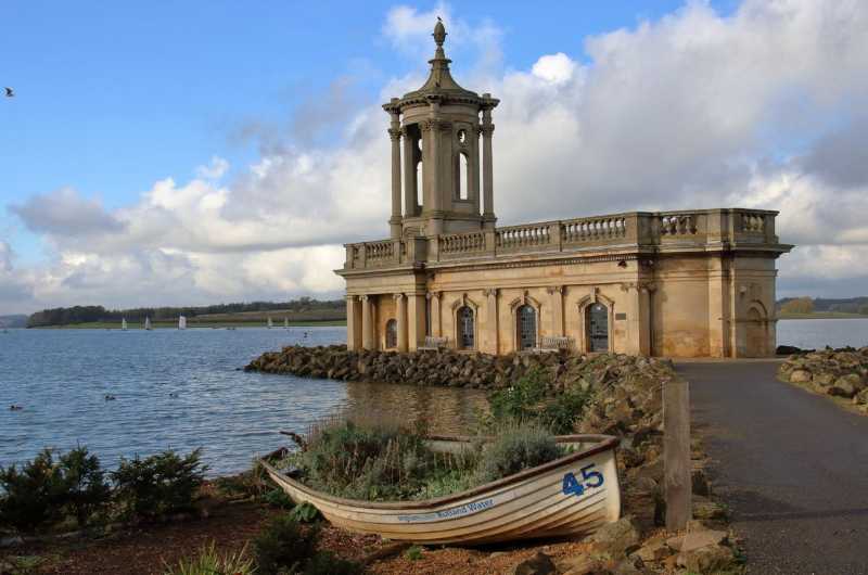
The picture shows Normanton Church. Rutland Water was created as a reservoir in the 1970s. This was achieved by building a dam and flooding the valley behind it. Two small villages were lost in the process, and it was planned that the deconsecrated church at Normanton would also be demolished. However, following representations from the public, a different plan was adopted.

Approximately half the church was filled with rubble topped with concrete. This raised the floor level to just below the original windows, and just above the planned level for the lake. The church was surrounded by some large boulders to form a breakwater, and a causeway was constructed to link what would have become an island to the shore a few metres away. It has been said that, from a distance, the church appears to float on the surface of the water. The building has been converted for use as a venue for concerts and civil weddings.
11. Norfolk Broads

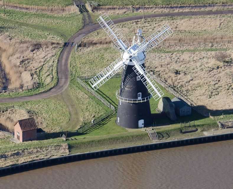
The picture shows Berney Arms Windmill in Norfolk. It is on the bank of the River Yare at the south-western end of Breydon Water. The windmill was originally built in the middle of the nineteenth century for grinding cement powder. However, it was repurposed just under twenty years later and used to pump water out of the surrounding fenland.

By the middle of the twentieth century the windmill was no longer in use, since a motorised pump had taken over. The building was deemed to be of historical importance and has been maintained and refurbished since under the care of English Heritage. At first glance, one might assume that it is constructed from stained or painted boards, but the mill is built from brick which has been given a coating of black tar.
12. English Channel

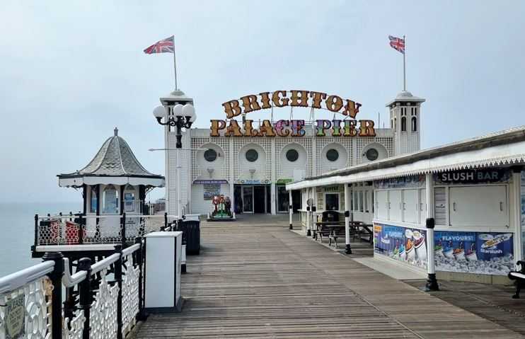
The picture shows the Brighton Palace Pier, which is on the south coast of England, and stretches for almost a third of a mile into the English Channel. It was originally built at the end of the nineteenth century to replace the Chain Pier which was falling apart. At that time it was one of two piers in Brighton, but the West Pier closed in the 1970s, and by the twenty-first century it was in ruins.

The Palace Pier has been home to a theatre, restaurants, shops, amusement arcades, theme park rides, and children's play areas at various times in its history. It has also featured in a number of films and television programs. These include "Carry On at Your Convenience", the film made from Graham Greene's book "Brighton Rock", and The Who's video "Quadrophenia".
Source: Author Lottie1001

This quiz was reviewed by FunTrivia editor agony before going online.
Any errors found in FunTrivia content are routinely corrected through our feedback system.
Related Quizzes
1. What's the British River? Easier
2. British Rivers and Cities Average
3. Surrounded By Water Average
4. The English Channel Average
5. A Journey along the River Wye Tough
6. British Rivers Average
7. Rivers of Britain Average
8. Bah, Humber! Very Easy
9. A River Runs Through It Average
10. Sail On, Silver Girl Easier
11. River Lea Average
12. River Severn Average

8/25/2026, Copyright 2026 FunTrivia, Inc. - Report an Error / Contact Us