FREE! Click here to Join FunTrivia. Thousands of games, quizzes, and lots more!
Lines of Latitude and Longitude Quizzes, Trivia and Puzzles
Lines of Latitude and Longitude Quizzes, Trivia

Lines of Latitude and Longitude Trivia

Lines of Latitude and Longitude Trivia Quizzes

  1. Home
  2. »
  3. Quizzes
  4. »
  5. Geography Trivia
  6. »
  7. Maps

Fun Trivia
20 quizzes and 220 trivia questions.
1.
  Longitude 60 West   popular trivia quiz  
Multiple Choice
 10 Qns
The 60th meridian west of Greenwich crosses several countries in the Americas. Let's find out what places are on that imaginary line.
Average, 10 Qns, ozzz2002, Mar 13 24
Average
ozzz2002 gold member
Mar 13 24
126 plays
2.
To A New Day
  To A New Day   top quiz  
Photo Quiz
 10 Qns
International Date Line
Travelling westward and crossing the International Date Line? Then remember to set your clock forward by 24 hours -- to a new day! This quiz explores the historical, geographical, and temporal aspects of this demarcation on Earth where a new day begins.
Easier, 10 Qns, Matthew_07, Feb 13 23
Easier
Matthew_07 gold member
Feb 13 23
376 plays
3.
  Zero   popular trivia quiz  
Ordering Quiz
 10 Qns
Travelling Down the Prime Meridian
The Prime Meridian is defined as 0° longitude. Starting at the top of the world (in the north) put these places in the order that they lie on, or very close to, that line.
Average, 10 Qns, Lottie1001, Jul 12 23
Average
Lottie1001 gold member
Jul 12 23
341 plays
4.
Between the Lines Notable Circles of Latitude
  Between the Lines: Notable Circles of Latitude    
Photo Quiz
 10 Qns
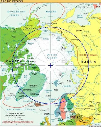
Circles of latitude, also known as lines of latitude, or parallels, are imaginary horizontal lines that run across the Earth. This quiz tests your geographical knowledge on ten notable circles of latitude, from north to south. Enjoy the ride!
Easier, 10 Qns, Matthew_07, Jun 13 21
Easier
Matthew_07 gold member
Jun 13 21
287 plays
5.
  The Amazing Equator   top quiz  
Multiple Choice
 10 Qns
The Equator is an imaginary line that cuts the world in half. Here are some questions about it and countries through which it passes.
Average, 10 Qns, Christinap, Aug 07 21
Average
Christinap
Aug 07 21
5191 plays
6.
  The 37th Parallel   top quiz  
Multiple Choice
 10 Qns
Seoul and the surrounding Gyeonggi province lie on the 37th parallel north. All of the places here sit on the same circle of latitude. They all call 37 degrees north of the equator their home.
Easier, 10 Qns, AcrylicInk, Jul 28 22
Easier
AcrylicInk gold member
Jul 28 22
392 plays
7.
  A Line Runs Through It - The Tropic of Cancer   popular trivia quiz  
Multiple Choice
 15 Qns
The Tropic of Cancer, also known as the Northern Tropic, is located approximately 23.4 degrees north of the equator. This circle of latitude passes through 15 different countries and some notable bodies of water. Enjoy!
Easier, 15 Qns, Matthew_07, May 18 20
Easier
Matthew_07 gold member
May 18 20
415 plays
8.
  A Line Runs Through It - The Equator   great trivia quiz  
Multiple Choice
 10 Qns
The Earth's equator, located equidistant from the North and South Poles, divides the globe into two hemispheres. This imaginary line passes through some notable countries and bodies of water. Let's learn more about this major circle of latitude. Enjoy!
Easier, 10 Qns, Matthew_07, Jul 28 22
Easier
Matthew_07 gold member
Jul 28 22
317 plays
9.
  Ralph the Llama Celebrates the 48th   great trivia quiz  
Multiple Choice
 15 Qns
Ralph the Llama is familiar with the 48th parallel south, as this runs through Argentina and Chile, so he has decided to circumnavigate the world using the 48th parallel north. Join him on his journey of discovery.
Average, 15 Qns, glendathecat, Jul 28 22
Average
glendathecat
Jul 28 22
1459 plays
10.
  It's a Long Way from LA to Denver   popular trivia quiz  
Multiple Choice
 10 Qns
...especially if you start by flying west! Here are some of the sights you might see as you travel from Los Angeles to Denver, staying within the latitudes of those two cities (34N and 39N).
Average, 10 Qns, looney_tunes, Jul 28 22
Recommended for grades: 10,11,12
Average
looney_tunes editor
Jul 28 22
342 plays
11.
  A Line Runs Through It - The Tropic of Capricorn   popular trivia quiz  
Multiple Choice
 10 Qns
The Tropic of Capricorn, also known as the Southern Tropic, is located approximately 23.4 degrees south of the equator. This circle of latitude passes through ten different countries and some notable bodies of water. Enjoy!
Very Easy, 10 Qns, Matthew_07, Feb 27 23
Recommended for grades: 9,10,11,12
Very Easy
Matthew_07 gold member
Feb 27 23
367 plays
12.
  "Criss-cross" around the Globe    
Multiple Choice
 10 Qns
A journey along parallels and meridians.
Tough, 10 Qns, Mr5, Nov 14 19
Tough
Mr5
Nov 14 19
6970 plays
13.
  Longitude 30 East   great trivia quiz  
Multiple Choice
 10 Qns
I spun my globe and my finger landed on Longitude 30 degrees East. This imaginary line passes through several countries in Europe, Asia and Africa. My quiz is about some of these countries.
Average, 10 Qns, ozzz2002, Jul 28 22
Average
ozzz2002 gold member
Jul 28 22
419 plays
14.
  Longitude 70 West   great trivia quiz  
Multiple Choice
 10 Qns
The 70th meridian West crosses both of the Americas. Let's visit a few of the places that it passes through.
Average, 10 Qns, ozzz2002, Jul 28 22
Average
ozzz2002 gold member
Jul 28 22
264 plays
15.
  Capricorn, Cancer or Equator   popular trivia quiz  
Multiple Choice
 10 Qns
The concept of this quiz is simple: tell me which places are on which of these lines of latitude and vice versa.
Average, 10 Qns, AlonsoKing, Jan 31 23
Average
AlonsoKing
Jan 31 23
493 plays
16.
  Tropical Paradises or Not    
Multiple Choice
 15 Qns
Identify whether a country is in the tropics (between Tropics of Cancer and Capricorn), in the temperate zone, or partly in both. Country does not include far-flung colonies, protectorates, or territories. Roughly the tropics lie between Havana and Rio.
Average, 15 Qns, SixShutouts66, Jul 28 22
Average
SixShutouts66 gold member
Jul 28 22
210 plays
17.
  Follow the Line Multiple Choice Quiz    
Multiple Choice
 10 Qns
In this quiz we will be testing your eyesight as well as your brain. You will be asked about areas on Earth that lie on either the same latitude, longitude or other navigational line, so keep a map, a globe or GoogleEarth handy.
Tough, 10 Qns, RedHook13, Jul 28 22
Tough
RedHook13 gold member
Jul 28 22
348 plays
18.
  Equatorial Countries    
Multiple Choice
 15 Qns
There are fifteen countries in the world through which the equator passes. This is a quiz on those 15 countries. Have fun!
Tough, 15 Qns, namastheg, Jul 28 22
Tough
namastheg
Jul 28 22
1967 plays
19.
  Latitude With Attitude    
Multiple Choice
 10 Qns
Locating places on the planet involves latitude and longitude. We will focus on the former which is the distance from the Equator expressed in degrees, seconds and minutes. It helps to think globally.
Average, 10 Qns, njbruce, Jul 28 22
Average
njbruce gold member
Jul 28 22
201 plays
20.
  East or West? North or South?    
Multiple Choice
 10 Qns
I'll name two or four well known geographic locations with the similar latitude or longitude. You have to answer which one of the choices is the most to the north or south, or the most to the east or west. Have fun!
Difficult, 10 Qns, St Sava Jr., Jan 13 24
Difficult
St Sava Jr.
Jan 13 24
532 plays

Lines of Latitude and Longitude Trivia Questions

1. The South Korean capital of Seoul lies on the 37th parallel and is home to Changdeokgung Palace Complex. One of its celebrated features sounds like something from a Frances Hodgson Burnett novel. What is it?

From Quiz
The 37th Parallel

Answer: The Secret Garden

The Changdeokgung Palace Complex was built at the base of a mountain during the 15th century. In 1997, the building was designated a UNESCO World Heritage Site. It was recognised for the inclusion of the natural landscape in its design. The palace followed pungsu principles; the belief that topography and the position of the home has an effect on an individual's fortune.

2. Which two locations are closest to the same latitude as opposed to the other pairs listed?

From Quiz Latitude With Attitude

Answer: Brazil and Tanzania

In the southern hemisphere, Brazil and Tanzania are closest to the same point in latitude. They both lie across the 6th parallel south. The other pair locations listed are situated in opposite hemispheres from each other.

3. Which geographical zone or zones is Australia in?

From Quiz Tropical Paradises or Not

Answer: Tropical and South Temperate

Hopefully you remembered that Australia is the answer to trivia chestnut " which continent is divided nearly in half by the Tropic of Capricorn". The Australian landmass ranges between about 15 and 45 degrees south latitude. Sydney, in the south, bears a striking resemblance to temperate San Francisco in many respects - even their relative northern/southern latitudes. But Australia is also the tropical Great Barrier Reef and the crocodile-infested Top End of the "Crocodile Dundee" movies.

4. This Egyptian city, with a 2015 population of over four million, sits astride longitude 30 East. Which coastal city is it?

From Quiz Longitude 30 East

Answer: Alexandria

Alexandria is the second largest city in Egypt, behind Cairo. It is a large Mediterranean seaport, located on the western part of the Nile River delta. Cairo, Luxor and Aswan are not coastal- they are all on the Nile River.

5. Part of the largest of the Galapagos Islands lays directly on the Equator. What is the name of this island?

From Quiz The Amazing Equator

Answer: Isabela Island

Isabela Island is named after Queen Isabella of Spain. The northern part of the island lays on the Equator. The Galapagos are home to some of the most diverse species on earth, and are carefully protected. Tourism is carefully regulated so as not to upset the animals or the ecological balance. The Galapagos Islands are a province of Ecuador.

6. Philadelphia, Pennsylvania lies near the N40 latitude line. If we were to travel east on the same line, which city would we hit?

From Quiz Follow the Line

Answer: Madrid, Spain

Madrid, Spain lies nearest to the N40 latitude line. Paris and London lie closer to the N50 latitude line. Cairo lies on the N30 line.

7. On the west side of the Pacific Ocean, we find ourselves flying over the southern part of the island of Honshu, near the city which was the site of the first use of nuclear weapons in warfare. Which Japanese city was this?

From Quiz It's a Long Way from LA to Denver

Answer: Hiroshima

On the morning of 6 August 1945, at 8:15am local time, a USAAF bomber dropped an atomic bomb with the code name Little Boy on the city of Hiroshima. Most of the city was destroyed, and somewhere between 100,000 and 175,000 people died within the next six months as a direct result of the bombing. The city was first established around 1600 as a castle town, and developed into an industrial centre during the second half of the 19th century, becoming officially designated as a city in 1889. It was a military centre of some significance, but most of the deaths caused by the atomic bomb were civilians. The book 'Hiroshima' by John Hershey describes the lives of six survivors in the time immediately before the bombing, and during a period of four months afterwards. It makes powerful reading.

8. The 37th parallel passes through the Mediterranean Sea and some of the islands there. Which one is the historical town of Syracuse (Siracusa in Italian) on?

From Quiz The 37th Parallel

Answer: Sicily

Sicily is an Italian island off the coast of the mainland. The town was founded in 743 CE by Corinthians and has been witness to a vibrant history since then. In 2005, the town was designated a World Heritage Site for its abundant architecture spanning a long and colourful history. In 413 BCE, the town played a part in the Peloponnesian War and later became part of the Byzantine Empire. Roughly 300 years after Byzantine rule began, the Islamic Aghlabids took control of Syracuse and other parts of the island. Over time, the town was ruled by the Normans, the Aragons, and the Bourbons. Buildings and structures throughout the town are testament to its history.

9. Which two locations are closest to the same latitude as opposed to the other pairs listed?

From Quiz Latitude With Attitude

Answer: Canada and Russia

Canada and Russia are both in the northern hemisphere, the largest countries on the top of the globe. They both lie across the 50th parallel north. The other pair locations listed are situated in opposite hemispheres from each other.

10. Which geographical zone or zones is New Zealand in?

From Quiz Tropical Paradises or Not

Answer: South Temperate

Many in the Northern Hemisphere lump Australia and New Zealand together as far flung bastions of the British Empire in the South Pacific, an opinion that wouldn't be popular in either country. In terms of geography, the northernmost point of New Zealand is about the same latitude as Sydney; and New Zealand extends below the 45th parallel in the south.

11. 70 west meridian crosses the Dominican Republic just west of its capital, Santo Domingo. It also passes very close to the highest mountain in the West Indies, which reaches just over 3,000 metres. What is the name of this mountain?

From Quiz Longitude 70 West

Answer: Pico Duarte

Dominican Republic is one of two countries on the island of Hispaniola, the western third being occupied by Haiti. It is believed that Columbus made landfall on the island in 1492. On top of the mountain is a statue of Juan Pablo Duarte, a 19th century politician and founding father of the country, after who it was named. There are three other peaks nearby that comprise the four highest peaks in the Caribbean. Hkakabo Razi is the highest point in Myanmar, Mount Wilhelm is in Papua New Guinea and Grauspitz is the tallest mountain in Liechtenstein.

12. In which country does the equator pass some 32km south of the capital, Kampala?

From Quiz The Amazing Equator

Answer: Uganda

Situated in east Africa, Uganda is a landlocked country. The Equator passes through the country close to Kampala, the largest and capital city. To capitalise on tourism Kampala has several luxury hotels. In addition to equatorial tourism (many people visit locations just to stand on the equator), Uganda also offers safaris and other attractions.

13. Ralph crosses the border into Germany in order to take a walk in the Black Forest. He passes through the historic town of Freiburg. What is the English translation of the town's name?

From Quiz Ralph the Llama Celebrates the 48th

Answer: Free town

Freiburg (or Freiburg im Breisgau to give it its full name) is a gateway to the Black Forest and noted as one of the sunniest towns in Germany. It was founded in 1120 as a market town independent of outside control, hence the name of "free town". Ralph discovers that its other attractions include wine production; a university that dates from medieval times; a Catholic cathedral (Frieburg chose to ignore the Reformation!); and a drive towards ecological self-sufficiency. Glendathecat's off to enjoy the burger and fries if they're no longer required as the correct answer.

14. Port Moresby, the capital of Papua New Guinea is located on which island?

From Quiz Equatorial Countries

Answer: New Guinea

The western half of New Guinea is a province of Indonesia called Western New Guinea or West Papua.

15. Turkmenistan's highest peak lies on the 37th line of latitude and forms part of the border of a neighbouring country. Which doubly landlocked nation is on the other side of the mountain?

From Quiz The 37th Parallel

Answer: Uzbekistan

Ayrybaba, or Airibaba, is the highest mountain in Turkmenistan and sits on the narrow eastern border with Uzbekistan. Turkmenistan, Kazakhstan, Kyrgyzstan, Tajikistan, Afghanistan, are all landlocked central Asian countries. They surround Uzbekistan, making it doubly-landlocked. Ayrybaba is part of the Kughinang Mountains and is 3,138m high. It's roughly the same height as Gray Peak in the USA's Yellowstone National Park.

16. Which two countries are closest to the same latitude as opposed to the other pairs listed?

From Quiz Latitude With Attitude

Answer: Japan and Turkey

Japan and Turkey are both in the northern hemisphere and lie across the 40th parallel north. The other pair locations listed are situated in opposite hemispheres from each other.

17. Which geographical zone or zones is Singapore in?

From Quiz Tropical Paradises or Not

Answer: Tropical

The word "tropics" conjures up images of sandy beaches, relaxation, and perhaps naughtiness. Singapore, at least to those of us who haven't visited, doesn't fit this image. However, lying at the tip of the Malay Peninsula and extremely close to the equator, Singapore is definitely in the tropics.

18. The 70 west meridian extends from pole to pole, like all other meridians. It crosses over the northernmost point of Antarctica. What name is given to this area?

From Quiz Longitude 70 West

Answer: Antarctic Peninsula

The Antarctic Peninsula is due south of the tip of South America, and is the southern side of the Drake Passage. Wilkes Land is on the opposite side of the continent, and neither Queen Maud Land, on the Prime Meridian, or the Ross Ice Shelf, which is on the International Date Line, are anywhere near 70 west.

19. South Africa has three different capitals. Which city, the administrative capital, is closest to longitude 30 East?

From Quiz Longitude 30 East

Answer: Pretoria

Pretoria is in the north-east of the country, and only about 100kms west of 30 East. The legislative capital, Cape Town, is on the western coast. Bloemfontein, the judicial capital, is close to the centre of South Africa. Windhoek is not in South Africa; it is the capital of the neighbouring country of Namibia.

20. Which African lake, named for a British Queen, does the Equator pass through?

From Quiz The Amazing Equator

Answer: Lake Victoria

Lake Victoria is in three countries. Uganda, Kenya and Tanzania. It was first discovered by John Speke and he named it after Queen Victoria. It is the largest tropical lake in the world. The Equator passes through the Ugandan part of the lake, touching some of the Ugandan Ssese Islands.

21. Ralph continues his travels into Austria, heading to the birthplace of Mozart. While there, he hears rumors of a garden full of water games. What Salzburg landmark does Ralph trot off to, to view these watery wonders?

From Quiz Ralph the Llama Celebrates the 48th

Answer: Hellbrunn Castle

Hellbrunn Castle was built in the early 1600s by Markus Sittikus von Hohenems, the Prince-Archbishop of Salzburg. The water games were built under his direction due to his fondness for practical jokes and a number of them would squirt water at unsuspecting visitors. Hohensalzburg Castle, located on Festungsberg which is one of the peaks which surround Salzburg, is one of the oldest castles in Europe and has served as a defensive position, a prison and is now a tourist attraction. Nonnberg Abbey is made famous by "The Sound of Music" as the abbey in which Maria worked as a teacher. Salzburg Cathedral is a baroque cathedral which was the baptismal site of Mozart. EmmaF2008 would like to visit all of these places!

22. So here you are in Canada at 50 degrees northern latitude and 60 degrees western longitude. Very close to your location is the estuary of an important North American river. What river could this be?

From Quiz "Criss-cross" around the Globe

Answer: St Lawrence

The tide in the St Lawrence Gulf is very strong, washing away any sediments, making a large estuary.

23. The 34th parallel crosses Tibet. In 1951, Tibet was annexed by what neighbouring country?

From Quiz It's a Long Way from LA to Denver

Answer: China

Tibet's borders were fluid following the fall of the Tibetan Empire, as much of the eastern part was not under the control of the Tibetan government, located in the southwest of the plateau. The eastern area was controlled variously by the Lhasa government and the Chinese government over several centuries, until the end of the Qing dynasty in 1912 led to the Tibetan government declaring its independence, which was not recognized by the Chinese Republic. In 1951, the Chinese forcibly regained control of the entirety of Tibet, and abolished its regional government in 1959 to put an end to rebellion in the region. The ethnic Tibetans, and the Tibetan Buddhists whose religious leader (the Dalai Lama) has been forced into exile, continue to consider themselves an invaded nation.

24. Gao Miao is a temple with influences from Buddhism, Taoism, Confucianism, and even Christianity. Which country is it in?

From Quiz The 37th Parallel

Answer: China

In northern China, the city of Zhongwei is home to a peculiar place of worship. Built during the Ming Dynasty, Gao Miao is an unusual temple because it has influences from different religions. Things start to get bizarre when visitors venture underground. During the Cultural Revolution, a bunker was built beneath the temple. Since then, it has been converted into a fairground ride to Hell. Visitors journey through a maze of rooms with animatronics playing out scenes from the underworld.

25. The Tropic of Cancer passes through Lake Nasser, which serves as a reservoir for the Aswan Dam located in this Mediterranean nation. In which country, noted for its civilization and pyramids, is Lake Nasser located?

From Quiz A Line Runs Through It - The Tropic of Cancer

Answer: Egypt

Lake Nasser is one of the world's largest man-made lakes. The construction of the Aswan Dam led to the flooding of the lower region of Nubia, forcing the relocations of thousands of affected families. Egypt is known for being a cradle of civilization. The Great Pyramid of Giza, located in the Giza pyramid complex, is one of the Seven Wonders of the Ancient World.

26. Which two countries are closest to the same latitude as opposed to the other pairs listed?

From Quiz Latitude With Attitude

Answer: Chile and Australia

Chile and Australia are both in the southern hemisphere and lie across the 33rd parallel south. The other pair locations listed are situated in opposite hemispheres from each other.

27. Which geographical zone or zones is Japan (four main islands) in?

From Quiz Tropical Paradises or Not

Answer: North Temperate

The four major islands of Japan cover roughly the same degrees of latitude as most of the western United States (San Diego to Portland, Oregon). The prefecture of Okinawa, at approximately 26 degrees north latitude, is the closest Japan comes to reaching the tropics.

28. A large mountain range in Turkey is crossed by 30 East longitude. The highest peak is Mt. Demirkazýk, at 3,756m. What is the name of the range? It shares its name with an astrological star sign.

From Quiz Longitude 30 East

Answer: Taurus Mountains

The range runs along most of Turkey's Mediterranean coast, and near its border with Syria. It is over 500 kms long, and contains many peaks over the 3,000m mark.

29. In South America the Equator is close to Quito, capital of Ecuador. In which mountain range is this situated?

From Quiz The Amazing Equator

Answer: The Andes

The Equator passes just to the north of Quito, close to Mitad del Mundo. At the local museum a monument marks the place where the equator passes through the country. A blue line across the plaza of the museum marking the line of the Equator is a popular spot for tourists to have their photographs taken. The usual pose is straddling the line with one foot in the Northern Hemisphere and one foot in the Southern.

30. Hong Kong lies just below the Tropic of Cancer. If we run our fingers along the line, which city would we come nearest to?

From Quiz Follow the Line

Answer: Havana, Cuba

Havana, Cuba also lies very close to the Tropic of Cancer line. The Tropic of Cancer line lies approximately 23-24 degrees north of the equator. The tropic lines are boundaries that separate the tropical and temperate climate zones of the earth.

This is category 24971
Last Updated Apr 22 2024 11:06 AM
play trivia = Top 5% Rated Quiz, take trivia quiz Top 10% Rated Quiz, test trivia quiz Top 20% Rated Quiz, popular trivia A Well Rated Quiz
new quizzes = added recently, editor pick = Editor's Pick editor = FunTrivia Editor gold = Gold Member

Teachers / educators: FunTrivia welcomes the use of our website and quizzes in the classroom as a teaching aid or for preparing and testing students. See our education section. Our quizzes are printable and may be used as question sheets by k-12 teachers, parents, and home schoolers.

 ·  All questions, answers, and quiz content on this website is copyright FunTrivia, Inc and may not be reproduced without permission. Any images from TV shows and movies are copyright their studios, and are being used under "fair use" for commentary and education.