FREE! Click here to Join FunTrivia. Thousands of games, quizzes, and lots more!
Quiz about A Handy Guide to Fiji

A Handy Guide to Fiji Trivia Quiz


Are you after some basic facts about Fiji? Then this quiz on the South Pacific island nation might be just the thing you need. Try it and find out...

A photo quiz by Fifiona81. Estimated time: 4 mins.
  1. Home
  2. »
  3. Quizzes
  4. »
  5. Geography Trivia
  6. »
  7. Pacific Islands
  8. »
  9. Fiji

Author
Fifiona81
Time
4 mins
Type
Photo Quiz
Quiz #
381,228
Updated
Dec 03 21
# Qns
10
Difficulty
Average
Avg Score
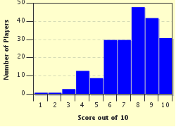
8 / 10
Plays
1953
Awards
Top 5% quiz!
Last 3 plays: Jooga1 (7/10), Nana7770 (6/10), Guest 45 (10/10).
-
Question 1 of 10
1. The majority of Fiji's population live on two main islands, Viti Levu and which other island whose name is reminiscent of one of the country's neighbours? Hint


Question 2 of 10
2. Lautoka, Fiji's second largest city, has which nickname derived from the main industry of the surrounding area? Hint


Question 3 of 10
3. In 2009, Fiji became the first nation to be suspended from which inter-governmental organisation dedicated to promoting economic growth, security and cooperation between Pacific nations? Hint


Question 4 of 10
4. The body of water to the north of the island of Viti Levu shares its name with the captain who was ousted from his ship during the infamous 'Mutiny on the Bounty'. What is it called? Hint


Question 5 of 10
5. If you went to a match at the ANZ National Stadium in Suva, which of these Olympic sports would you be likely to see? Hint


Question 6 of 10
6. Which outlying Fijian island is administered as a dependency and therefore has more local political autonomy than other areas of the country? Hint


Question 7 of 10
7. Mount Tomanivi is the highest point in Fiji, rising to around 1,300 metres (4,300 feet) above sea-level. By what name was it formerly known? Hint


Question 8 of 10
8. Two animals, neither of which is specifically symbolic of Fiji, appear on both Fiji's coat of arms and national flag. What are they? Hint


Question 9 of 10
9. The antipodes of Fiji mainly falls within which country of western Africa? Hint


Question 10 of 10
10. What name is given to the stretch of coastline on Viti Levu that includes the town of Sigatoka and is an important hub for the country's tourism industry? Hint


(Optional) Create a Free FunTrivia ID to save the points you are about to earn:

arrow Select a User ID:
arrow Choose a Password:
arrow Your Email:


View Image Attributions for This Quiz

Most Recent Scores
Apr 11 2024 : Jooga1: 7/10
Apr 09 2024 : Nana7770: 6/10
Apr 04 2024 : Guest 45: 10/10
Apr 03 2024 : Guest 166: 6/10
Apr 01 2024 : PurpleComet: 7/10
Mar 31 2024 : Guest 64: 6/10
Mar 21 2024 : Guest 165: 7/10
Mar 17 2024 : Guest 202: 10/10
Mar 08 2024 : Guest 27: 9/10

Score Distribution

quiz
Quiz Answer Key and Fun Facts
1. The majority of Fiji's population live on two main islands, Viti Levu and which other island whose name is reminiscent of one of the country's neighbours?

Answer: Vanua Levu

Fiji, located in the South Pacific Ocean, is a country made up of over 300 islands, about a third of which are inhabited. However, nearly 90% of the population live on the largest two islands, Viti Levu and Vanua Levu. In Fijian, the name 'vanua' means land or the people and customs associated with the land. The island was also known historically as Sandalwood Island, following the discovery of sandalwood trees there in the early 19th century.

The centre of Vanua Levu is mountainous and heavily forested, so (like Viti Levu) all the main settlements are located on the coast. The main towns are Labasa and Savusavu - Labasa on the north-east coast is in an area largely dedicated to farming, while Savusavu on the south coast is noted for its hot springs and tourist resorts.

The picture clue shows a map of Vanuatu, another South Pacific island nation that is located approximately 1,200 kilometres (750 miles) west of Fiji - making it the country's second nearest neighbour (Tuvalu is slightly closer). Tonga and the Solomon Islands are also located in the same general vicinity.
2. Lautoka, Fiji's second largest city, has which nickname derived from the main industry of the surrounding area?

Answer: Sugar City

Sugar has been a major part of Fiji's economy since the 1860s when the cotton growing industry collapsed and farmers turned to sugar cane as a more profitable crop. Mills to process the raw cane were built over the following decades and a fully-fledged industry developed around the product. The mill in the city of Lautoka, on the west coast of Viti Levu (the largest island of Fiji), was built in the early 19th century and has grown to become a major employer in the area, while contributing to the city gaining the nickname of 'Sugar City'.

The meaning of Lautoka's real name is harder to discern if you don't speak Fijian - it translates into English as 'spear hit' and is popularly believed to derive from an incident when a local tribal chief shouted "Lau-toka" after spearing his unfortunate rival.

Agriculture in Fiji includes the production of wheat, ginger and coconut oil - however, the picture clue shows a field full of sugar cane plants.
3. In 2009, Fiji became the first nation to be suspended from which inter-governmental organisation dedicated to promoting economic growth, security and cooperation between Pacific nations?

Answer: Pacific Islands Forum

The organisation was first created in 1979 as the South Pacific Islands Forum, but changed its name in 1999 to reflect its growing membership and the wider location of some of these countries in other parts of the Pacific Ocean. Most of the island nations in the areas are members, including Australia and New Zealand. It is led by the Secretary-General of the Pacific Islands Forum Secretariat, who is appointed on a three-year basis and is based in Suva - the capital city of Fiji.

Fiji became the first nation to be suspended from the Pacific Islands Forum in the wake of the 2006 coup that saw the military leader Frank Bainimarama take control of the government. The Forum ejected Fiji three years later for failing to hold free and fair democratic elections (as did the Commonwealth of Nations). Fiji was readmitted in 2014 after a general election had finally been held.

The picture clue shows the logo of the Pacific Islands Forum. The incorrect options are all other regional organisations of which Fiji is a member.
4. The body of water to the north of the island of Viti Levu shares its name with the captain who was ousted from his ship during the infamous 'Mutiny on the Bounty'. What is it called?

Answer: Bligh Water

Bligh Water is in western Fiji and is bounded by Viti Levu to the south, Vanua Levu to the north-east and the Yasawa island chain to the west. It covers an area of approximately 9,500 square kilometres (3,700 square miles) and is named after the British Royal Navy officer, William Bligh, who was infamously ousted from his command of HMS Bounty in 1789. The mutineers left Bligh and his supporters floating about near Tonga in one of the Bounty's boats. Bligh and the remnants of his crew then sailed the small vessel to what is now the city of Kupang in Indonesia - his route took him through the area now known as Bligh Water.

Interestingly, losing his ship in such an infamous event didn't particularly damage the then Lieutenant Bligh's naval career. He was promoted to captain just three years later and by the end of his career, he was a vice admiral.

The Cook Strait (named after Captain James Cook) separates New Zealand's North Island from the South Island; the Straits of Magellan (after Ferdinand Magellan) separate Tierra del Fuego from the South American mainland; and the (Abel) Tasman Sea lies between Australia and New Zealand.
5. If you went to a match at the ANZ National Stadium in Suva, which of these Olympic sports would you be likely to see?

Answer: Rugby sevens

Rugby (in all its forms) is one of the most popular sports in Fiji. Rugby sevens is based on rugby union but has only seven players per side and a much shorter match time (usually two halves of seven minutes each). Fiji has a particularly successful international rugby sevens team; they have won the Hong Kong Sevens competition multiple times since their first victory in 1977 and hold the honour of being the first nation to win the Rugby World Cup Sevens more than once.

Suva's ANZ National Stadium was built in 1951 and is a multi-purpose venue that features rugby league, rugby union, football (soccer) and athletics events in addition to rugby sevens matches.

The picture clue shows Rugby School in Warwickshire, England (complete with rugby pitch) - the school gave its name to the game of rugby, which was developed there in the 19th century. The incorrect options are all team sports that have been contested at the Olympic Games.
6. Which outlying Fijian island is administered as a dependency and therefore has more local political autonomy than other areas of the country?

Answer: Rotuma

The dependency of Rotuma (which consists of Rotuma Island itself and a few surrounding islets) is located about 650 kilometres (400 miles) north of the Fijian capital, Suva. However, it is not just the distance from the rest of Fiji that influenced its treatment as a semi-autonomous dependency, but the fact that Rotumans are a distinct indigenous ethnic group. Rotuma only became part of Fiji in 1881 when it was claimed by the British and added to their existing territory in Fiji - it remained part of the nation when independence was achieved in 1970.

Rotuma Island is volcanic, with a thin isthmus connecting the smaller western end of the island to the rest of the land mass. Its administrative capital is the town of Ahau, which is also home to the elected Council of Rotuma - the body that manages local government services and important aspects of day to day life on the island.

The incorrect options are all outlying islands or reefs of the Fijian archipelago, as can be seen in the map of Fiji shown in the picture clue.
7. Mount Tomanivi is the highest point in Fiji, rising to around 1,300 metres (4,300 feet) above sea-level. By what name was it formerly known?

Answer: Mount Victoria

Mount Tomanivi is an extinct volcano that now forms the highest point of both the island of Viti Levu and Fiji as a whole. Although a difficult walk, a fit person can hike to the summit and back in a single day. Any tourists undertaking this excursion would also get a good chance to see the biodiversity of Fiji's heavily forested interior on the way up. Once at the top, the old volcanic crater becomes visible and there is a spectacular view out towards the Yasawa Islands that include Fiji's most westerly point.

Fiji became a British colony in 1874 during the reign of Queen Victoria (the picture clue shows the Victoria Memorial in London), so it is hardly surprising that the country's highest point was formerly known as Mount Victoria. The new name for the mountain is definitely more distinctive though and prevents the mountain from being confused with the two Mount Victorias in New Zealand or the Mount Victoria in Papua New Guinea.
8. Two animals, neither of which is specifically symbolic of Fiji, appear on both Fiji's coat of arms and national flag. What are they?

Answer: A lion and a dove

The lion and the dove both feature on the escutcheon (shield) of Fiji's coat of arms - a symbol that is also prominently positioned on the national flag (as shown in the picture clue). The dove is the traditional symbol of peace and holds an olive branch in its beak, while the lion is a heraldic lion passant guardant (i.e. walking with its head facing towards the viewer) and represents Fiji's past as a British colony. Other symbols featured represent some of Fiji's natural resources - a bunch of bananas, a coconut palm and sugarcane. The escutcheon is then flanked by two native Fijian warriors and topped with a crest depicting a traditional type of Fijian sailing canoe. The motto shown underneath translates as "Fear God and honour the Queen" - another reminder of the country's colonial past, although perhaps not quite such an obvious one as the inclusion of Britain's Union Jack in the design of the Fijian flag.

The kangaroo and emu are symbols of Australia, a duck is one of the key characters in Prokofiev's 'Peter and the Wolf' and an owl and a pussy-cat "went to sea in a beautiful pea-green boat" in a nonsense poem by Edward Lear.
9. The antipodes of Fiji mainly falls within which country of western Africa?

Answer: Mali

If you dug a hole straight down along the diameter of the Earth, the point at which you would come out on the other side of the planet is known as the antipodes. (Obviously, actually doing this would be completely impractical - you'd be much better off just measuring where you'd come out and hopping round by aeroplane). The antipodes of most places in Fiji is the country of Mali in western Africa. It is also probably one of the most different countries from Fiji that you could imagine - while Fiji is a small archipelago covered in lush vegetation, Mali is large (it covers around 1.2 million square kilometres or 480,000 square miles), landlocked and mainly covered by the Sahara Desert.

However, if you started digging your hole on the Fijian island of Rotuma, the antipodes that you'd emerge at are in Mali's southern neighbour, Burkina Faso - also quite large, very landlocked and somewhat arid.

The picture clue shows the flag of Mali (a tricolour of green, gold and red) superimposed onto an outline map of the country. The incorrect options are all countries in eastern Africa.
10. What name is given to the stretch of coastline on Viti Levu that includes the town of Sigatoka and is an important hub for the country's tourism industry?

Answer: Coral Coast

The Coral Coast is the name given to around 80 kilometres (50 miles) of the coastline around the southern half of the Fijian island of Viti Levu. It stretches from the capital city, Suva, in the east to the city of Nadi in the west. The Coral Coast is the centre of Fiji's tourism industry, with a whole host of resorts and hotels to go with miles of beaches and stunning scenery. The town of Sigatoka stands at the mouth of the Sigatoka River and is home to the Sigatoka Sand Dunes National Park and the Kula Eco Park nature reserve, which are both popular tourist attractions.

Unsurprisingly, the Coral Coast takes its name from the offshore coral reefs that surround the area. The abundance of these beautiful natural habitats (like the one shown in the picture clue) also provides tourists with something else to do - swimming, snorkelling and diving!
Source: Author Fifiona81

This quiz was reviewed by FunTrivia editor Tizzabelle before going online.
Any errors found in FunTrivia content are routinely corrected through our feedback system.
Related Quizzes
This quiz is part of series A Handy Guide to...:

Are you after some basic facts about countries and places around the world? Then these quizzes might be just the thing you need. Try them and find out...

  1. A Handy Guide to the Caribbean Easier
  2. A Handy Guide to Colombia Average
  3. A Handy Guide to Ethiopia Average
  4. A Handy Guide to Fiji Average
  5. A Handy Guide to Kazakhstan Average
  6. A Handy Guide to Mauritius Average
  7. A Handy Guide to Papua New Guinea Average
  8. A Handy Guide to Paraguay Average
  9. A Handy Guide to Singapore Average
  10. A Handy Guide to Spain Average
  11. A Handy Guide to Vanuatu Average
  12. A Handy Guide to Venezuela Easier

4/25/2024, Copyright 2024 FunTrivia, Inc. - Report an Error / Contact Us