FREE! Click here to Join FunTrivia. Thousands of games, quizzes, and lots more!
Quiz about Taiwan Republic of China

Taiwan (Republic of China) Trivia Quiz


While Taiwan is not recognized by the United Nations, many countries do recognize it as an independent country. The political situation is complex, this quiz is not.

A multiple-choice quiz by looney_tunes. Estimated time: 4 mins.
  1. Home
  2. »
  3. Quizzes
  4. »
  5. Geography Trivia
  6. »
  7. Asia
  8. »
  9. Taiwan

Author
looney_tunes
Time
4 mins
Type
Multiple Choice
Quiz #
345,052
Updated
Dec 03 21
# Qns
10
Difficulty
Average
Avg Score
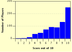
8 / 10
Plays
3440
Awards
Top 5% quiz!
Last 3 plays: Guest 143 (10/10), MikeMaster99 (10/10), matthewpokemon (9/10).
- -
Question 1 of 10
1. Taiwan is the name commonly used when referring to the Republic of China (ROC), as distinct from the People's Republic of China (PRC), usually called simply China. What other name is commonly used to refer to the country instead of the Republic of China, especially by international organizations such as the International Olympic Committee? Hint


Question 2 of 10
2. The island of Taiwan is located off the coast of China. Which of these bodies of water separates it from the Asian mainland? Hint


Question 3 of 10
3. In one of the local dialects, natives of the island of Taiwan describe themselves as "children of the Sweet Potato". To what does this name refer? Hint


Question 4 of 10
4. The official position of the island of Taiwan is given as 23° 46' N and 121° 00' E. Given this, which of these lines of latitude passes through the centre of the island? Hint


Question 5 of 10
5. The Taiwanese archipelago was formed about 4 or 5 million years ago when the Eurasian Plate and the Philippine Sea Plate collided. Which of the following is a term for this kind of island? Hint


Question 6 of 10
6. How might the terrain of the island of Taiwan best be described? Hint


Question 7 of 10
7. Taiwan is home to the world's fourth-highest mountain on an island. Formerly known as Mount Morrison and as Mount Niitaka, this peak has which of the following contemporary names? Hint


Question 8 of 10
8. The Chianan Plain covers most of the western third of the island of Taiwan. It is an important agricultural area. Which of these is the most important crop produced there at the start of the 21st century? Hint


Question 9 of 10
9. It is estimated that 20% of the plant and animal species found in Taiwan are endemic. What does this mean? Hint


Question 10 of 10
10. As well as the threat of earthquakes, residents of Taiwan can expect which of the following environmental events, possibly catastrophic, between July and October each year? Hint


(Optional) Create a Free FunTrivia ID to save the points you are about to earn:

arrow Select a User ID:
arrow Choose a Password:
arrow Your Email:


Most Recent Scores
Apr 11 2024 : Guest 143: 10/10
Mar 23 2024 : MikeMaster99: 10/10
Mar 23 2024 : matthewpokemon: 9/10
Mar 23 2024 : Gispepfu: 8/10
Mar 23 2024 : shorthumbz: 8/10
Mar 23 2024 : kysus: 10/10
Mar 23 2024 : George95: 8/10
Mar 23 2024 : BarbaraMcI: 9/10
Mar 23 2024 : gracious1: 8/10

Score Distribution

quiz
Quiz Answer Key and Fun Facts
1. Taiwan is the name commonly used when referring to the Republic of China (ROC), as distinct from the People's Republic of China (PRC), usually called simply China. What other name is commonly used to refer to the country instead of the Republic of China, especially by international organizations such as the International Olympic Committee?

Answer: Chinese Taipei

The name Chinese Taipei refers to the capital city of the ROC, Taipei, which is also the largest city by area on the island of Taiwan. At the start of the 21st century, most of the land claimed by the ROC is in the archipelago of which Taiwan is the largest island, although it started on mainland China in 1912. After World War II, Taiwan was gained from the Japanese. During the Chinese Civil War (1927-1950) the ROC fought against the Chinese Communist Party for control of the country, which eventually led to the establishment of two entities, the Communist PRC, in control of most of mainland China, and the Nationalist ROC, based in the Taiwanese archipelago. Although the Civil War is generally considered to have ended with active fighting in 1950, 60 years later the two groups each claim the other's territory. The name "Chinese Taipei" is considered politically neutral, and is used when ROC wishes to participate in international events which also include the PRC.

Formosa is an alternative name for the island of Taiwan, derived from the Portuguese name, "Ilhe Formosa", meaning "Beautiful Island". Singapore is a multi-island country off the coast of Malaysia, and Ceylon is the name given to Sri Lanka during the era of British colonialism.
2. The island of Taiwan is located off the coast of China. Which of these bodies of water separates it from the Asian mainland?

Answer: Taiwan Strait

The Taiwan Strait has an average width of 160 km (100 mi), and lies between Taiwan and the mainland to its west. The East China Sea is to the north, the Philippine Sea to the east, and the Luzon Strait on the south separates Taiwan from the Philippine island of Luzon. The South China Sea is to the southwest of Taiwan. All of these are part of the Pacific Ocean.
3. In one of the local dialects, natives of the island of Taiwan describe themselves as "children of the Sweet Potato". To what does this name refer?

Answer: The shape of the island

The island of Taiwan does look rather like a sweet potato, with a bit of imagination. It is an elliptical shape, oriented roughly north-south. Its longest axis is about 395 km (245 mi) long, and its width is about 145 km (90 mi). Sweet potatoes are a popular food in many Asian and Polynesian countries, including Taiwan, but not the most important staple food.

Early maps drew the island as it is approached from the west, so that the length spreads from side to side of the map, showing the shape in a different light, which has led to it being compared to a whale.
4. The official position of the island of Taiwan is given as 23° 46' N and 121° 00' E. Given this, which of these lines of latitude passes through the centre of the island?

Answer: Tropic of Cancer

These lines of latitude mark zones on the earth which are determined by the changes in the sun's apparent motion due to the inclination of the earth's axis of rotation in relation to the plane of its orbit around the sun. The Tropic of Cancer (north of the Equator) and the Tropic of Capricorn (to the south) are located at about 23°, and mark the extremities of the zone in which the sun is ever directly overhead at noon. (The exact location of the lines changes very slowly over time, as the earth's inclination is not fixed.) On the tropics, this happens only once a year, on the day of the summer solstice. The polar Circles (Arctic in the north, Antarctic in the south) mark the edge of the circumpolar region in which there is a period of 24-hour daylight (in the summer) and one of 24-hour night (in the winter). They currently lie at a latitude of around 66.5°.

Because the Tropic of Cancer runs through the centre of the island, its southern half is technically tropical, and the northern half is technically sub-tropical. The northern part of the island has a monsoonal weather pattern, with heavy rain from January through March, and again around May, when a stationary front usually forms in the region, until the subtropical ridge develops sufficiently to move the front further north for the summer.
5. The Taiwanese archipelago was formed about 4 or 5 million years ago when the Eurasian Plate and the Philippine Sea Plate collided. Which of the following is a term for this kind of island?

Answer: Tectonic island

The tectonic interactions around Taiwan are complex (and ongoing). There are several plates colliding in the area, so the statement in the question about two colliding plates is very much simplified. South of the island, the Philippine Sea Plate is subducting (moving downwards) under the Sunda Plate; north of the island, it is subducting under the Okinawa Plate. The island is at the junction of the volcanic arcs created by these two separate interactions, called the Luzon Volcanic Arc and the Ryukyu Volcanic Arc.

All of this tectonic action means that Taiwan experiences many earthquakes. The United States Geological Survey identifies about 90% of the island as belonging to the zone of extreme seismic hazard.
6. How might the terrain of the island of Taiwan best be described?

Answer: Mountains in the eastern two-thirds, flat plains in the western one-third

The mountains are in five different ranges running the length of the island: Central, Hsueshan, Yushan, Alishan and Coastal. They include around 200 peaks over 3000 m (9800 ft) in elevation. A list of 100 of these has been compiled, which mountaineers scale much as UK climbers try to collect all the Munros.

The mountains are home to a diverse native flora and fauna, and few people. Over 90% of the island's population can be found in the plains and hills of the west. During the time of Japanese rule (1895-1945), much of the timber resource of the mountains was used to for construction of buildings and shrines, and the timber industry has never fully recovered.
7. Taiwan is home to the world's fourth-highest mountain on an island. Formerly known as Mount Morrison and as Mount Niitaka, this peak has which of the following contemporary names?

Answer: Yushan

Yushan, which translates as Jade Mountain, is the highest mountain in East Asia, at 3952 m (12966 ft). It also contains the highest point on the Tropic of Cancer, which passes across it. After W. Morrison, captain of the SS Alexander, sighted the peak in 1857, it was referred to as Mount Morrison in European and American records. During the Japanese annexation of Taiwan, the mountain was renamed Mount Niitaka, meaning 'New High Mountain', a reference to the fact that it was slightly higher than Mount Fuji, the highest mountain in Japan. This name was part of the Japanese secret code signal to begin the attack on Pearl Harbor in December of 1941 - the message 'Niitakayama Nobore' literally means 'Climb the New High Mountain'.

The world's four highest peaks on islands are Puncak Jaya (on the island of New Guinea), Mauna Kea (on the island of Hawaii) and Mount Kinabulu (on the island of Borneo).
8. The Chianan Plain covers most of the western third of the island of Taiwan. It is an important agricultural area. Which of these is the most important crop produced there at the start of the 21st century?

Answer: Rice

Rice is Taiwan's most important food crop, and intensive farming means that three crops can be harvested each year from the paddy fields. This was the region where native Taiwanese lived before the arrival of Han Chinese immigrants, and the area where the Japanese developed agriculture during their rule. Sugarcane used to be an important crop, but that has diminished in recent years.

As well as a number of other vegetable crops, the plain used to be an important centre for producing salt in evaporation ponds, but they are no longer operational.
9. It is estimated that 20% of the plant and animal species found in Taiwan are endemic. What does this mean?

Answer: Taiwan is the only place in the world where they are found

A species (or subspecies) is endemic to a region if that is the only place where it is found. Madagascar is well known for having a lot of species which are only found there (and it's usually the answer to a trivia question about the only place where some species can be found), but other islands commonly have a number of endemic species. Taiwan's endemic species include plants such as the Formosan Cypress and the Taiwan Fir, land animals such as the Formosan Black Bear and the Formosan Sika Deer, and birds such as the Swinhoe's Pheasant and the Taiwan Blue Magpie.

Unfortunately, economic development has led to habitat pressure on many of the endemic species (most of which are found in the eastern mountains, especially near Yushan), and a number of them are designated as endangered.
10. As well as the threat of earthquakes, residents of Taiwan can expect which of the following environmental events, possibly catastrophic, between July and October each year?

Answer: Typhoons

Of these, only typhoons pose a seasonal threat to residents of Taiwan. Typhoon is the name given to tropical cyclones that form in the Pacific Ocean, while those that form in the Atlantic Ocean are usually referred to as hurricanes. Both of these are storm systems with winds of at least 119 kph (74 mph), in a rotational system that develops an eye, a relatively calm area in the centre of the storm, which appears on satellite images as a cloud-free zone surrounded by circular spirals of cloud.

Taiwan can expect, on average, four typhoons each year that make direct contact with the island. Many more pass nearby, and contribute to the island's high annual rainfall, which contributes to the lush vegetation in the mountains, and the high agricultural yields on the plains.
Source: Author looney_tunes

This quiz was reviewed by FunTrivia editor Tizzabelle before going online.
Any errors found in FunTrivia content are routinely corrected through our feedback system.
Related Quizzes
This quiz is part of series Written for the Bus Ride:

You think you can write just one, but it turns out that writing quizzes suitable for being visited by the tourists on the Bus Ride is addictive - there's just so much to find out!

  1. Saint Vincent and the Grenadines Average
  2. Barbados, Land of the Flying Fish Average
  3. Calypso Country - Trinidad and Tobago Average
  4. "The Land, the People, the Light" - Saint Lucia Average
  5. A Provincial Tour of Zimbabwe Average
  6. Republic of Benin, Formerly Dahomey Average
  7. The Landlocked Kingdom of Lesotho Average
  8. Honduras: "Free, Sovereign and Independent" Average
  9. Exploring Kosovo Average
  10. Democratic Republic of Sao Tome and Principe Average
  11. "We Stand With God" in Vanuatu Average
  12. They Came to Baghdad Average

4/19/2024, Copyright 2024 FunTrivia, Inc. - Report an Error / Contact Us