FREE! Click here to Join FunTrivia. Thousands of games, quizzes, and lots more!
Quiz about Britains Blue Borders Waters Around the UK

Britain's Blue Borders: Waters Around the UK Quiz


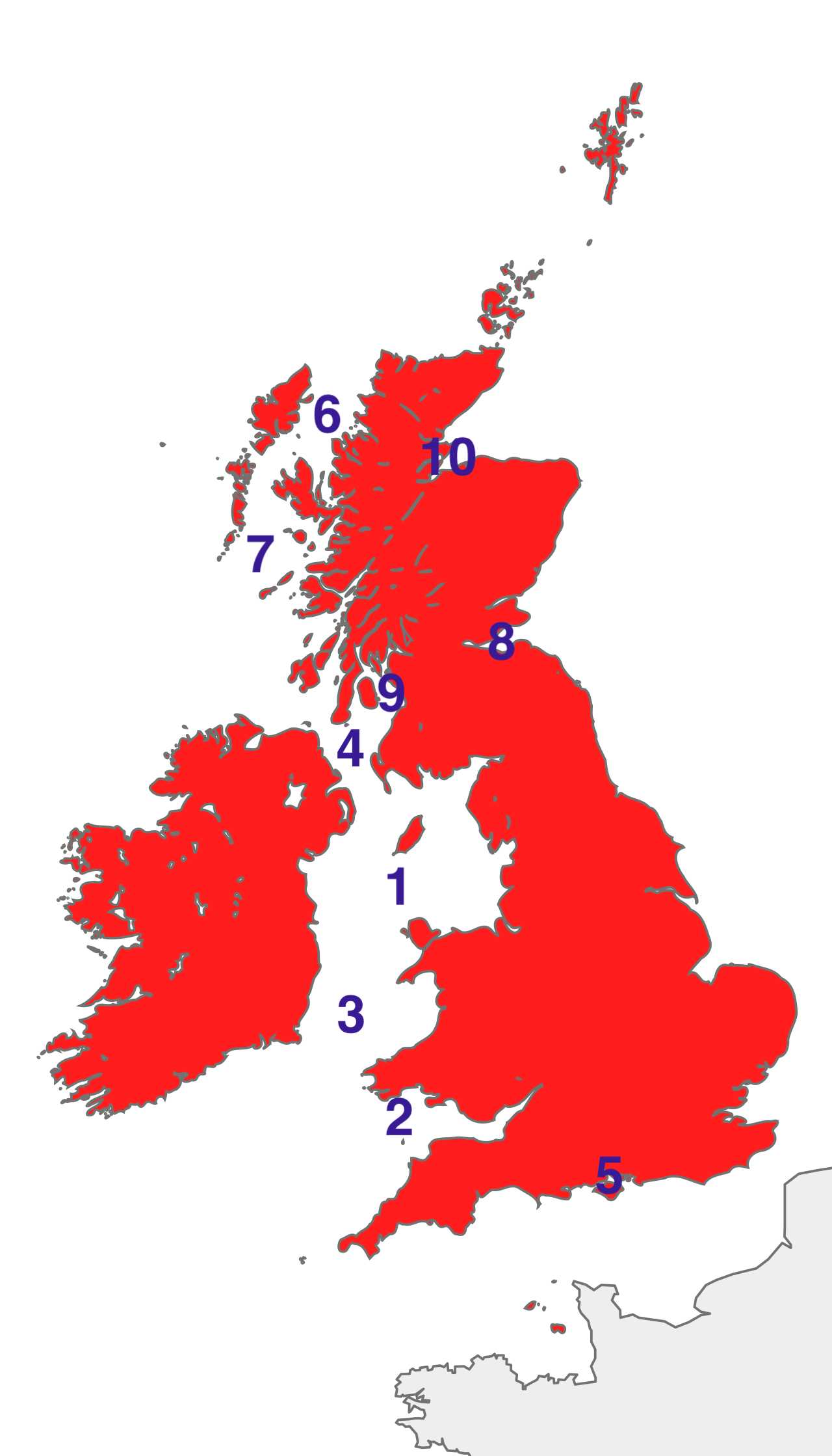
The United Kingdom is surrounded by a variety of seas, channels and coastal waters. Can you match the ten coastal waters on the map with their correct names?

A label quiz by wellenbrecher. Estimated time: 3 mins.
  1. Home
  2. »
  3. Quizzes
  4. »
  5. Geography Trivia
  6. »
  7. United Kingdom
  8. »
  9. UK Bodies of Water

Time
3 mins
Type
Label Quiz
Quiz #
425,044
Updated
Aug 01 26
# Qns
10
Difficulty
Easy
Avg Score
8 / 10
Plays
17
Last 3 plays: thomas1975 (6/10), Nicobutch (10/10), elgecko44 (6/10).
Click on image to zoom
Sea of the Hebrides Firth of Forth North Channel The Minch Moray Firth Firth of Clyde Irish Sea St. George's Channel Bristol Channel The Solent
* Drag / drop or click on the choices above to move them to the answer list.
View Image Attributions for This Quiz
1.   
2.   
3.   
4.   
5.   
6.   
7.   
8.   
9.   
10.   

Most Recent Scores
Today : thomas1975: 6/10
Today : Nicobutch: 10/10
Today : elgecko44: 6/10
Today : quizzer74: 8/10
Today : Reamar42: 10/10
Today : gwendylyn14: 2/10
Today : sarryman: 8/10
Today : bernie73: 5/10
Today : rossian: 8/10

Quiz Answer Key and Fun Facts
1. Irish Sea

The Irish Sea separates Great Britain from Ireland and provides a maritime connection between the North Channel and St George's Channel. It covers approximately 47,000 kmē (18,100 sq mi), with its deepest point reaching around 315 m (1,033 ft). Major ports along its shores are Liverpool, Dublin, Belfast and Douglas on the Isle of Man. For centuries, the sea has been a major route for trade and travel, with ferries and cargo vessels crossing its waters every day.

It is also home to the Isle of Man, known for the annual Isle of Man TT motorcycle race.
2. Bristol Channel

Stretching between South Wales and South West England, the Bristol Channel forms the passage between the Celtic Sea and the Severn Estuary. The channel has an area of approximately 7,000 kmē (2,700 sq mi) and its deepest waters reach around 50 m (164 ft). Coastal centres include Cardiff, Swansea, Bristol and Newport. With one of the highest tidal ranges in the world, water levels can rise and fall by more than 14 metres (46 ft) in extreme conditions.

These powerful tides have influenced navigation, fishing and industry in the region for centuries.
3. St. George's Channel

Separating south-eastern Ireland from south-western Wales, St George's Channel forms a sea route between the Irish Sea and the Celtic Sea. It extends for approximately 160 km (100 mi), with its deepest waters reaching around 100 m (328 ft). Rosslare, Fishguard and Pembroke are the principal coastal towns and ferry ports.

The channel has long been used by passenger ferries and cargo vessels travelling between Ireland and Great Britain. It is also part of the wider migration route of marine wildlife moving between the Atlantic Ocean and the waters around the British Isles.
4. North Channel

The North Channel separates Northern Ireland from south-western Scotland and forms the northern gateway between the Irish Sea and the Atlantic Ocean. It is around 150 km (93 mi) long and descends to approximately 272 m (892 feet). Its main ports are Belfast, Larne, Cairnryan and Stranraer.

At its narrowest point, the channel is just 21 km (13 mi) wide, making it the shortest sea crossing between Great Britain and Ireland. The channel remains a busy route for ferries, freight traffic and marine wildlife.
5. The Solent

The Solent is a narrow strait sheltered between England's south coast and the Isle of Wight. It links Southampton Water with the English Channel. Extending for around 32 km (20 mi), the strait is up to approximately 23 m (75 ft) deep. Southampton, Portsmouth, Cowes and Yarmouth are its main ports and marinas.

The Solent is one of the world's most famous sailing waters and hosts the annual Cowes Week, one of the oldest and largest sailing regattas. Its sheltered waters have also made it a strategically important naval and commercial waterway for centuries.
6. The Minch

The Minch, which lies between the Scottish mainland and the Outer Hebrides, connects the Sound of the Hebrides in the south with the North Atlantic in the north. Spanning approximately 5,700 kmē (2,200 sq mi), its deepest waters reach around 232 metres (761 feet). Ferry services operate from Ullapool, Stornoway and Lochmaddy.

The Minch is one of the best places in the UK to spot whales, dolphins and basking sharks, making it a popular destination for wildlife cruises. Despite its natural beauty, the Minch's strong tides and unpredictable weather have challenged sailors for centuries.
7. Sea of the Hebrides

The Sea of the Hebrides lies off the west coast of Scotland, stretching between the Inner and Outer Hebrides before opening onto the Atlantic Ocean. This extensive marine area covers approximately 47,000 kmē (18,100 sq mi) and reaches depths of up to 300 m (984 feet).

The region is served by ports and ferry terminals such as Oban, Castlebay, Lochboisdale and Tarbert. The sea is part of a Marine Protected Area established to protect whales, dolphins, basking sharks and other marine wildlife. The area's waters are also an important habitat for seabirds and other species found in the North Atlantic.
8. Firth of Forth

Running inland from the North Sea into eastern Scotland, the Firth of Forth forms a broad estuary around the River Forth. This waterway stretches for approximately 80 km (50 mi) and has a maximum depth of around 60 m (197 ft). Key maritime centres are Edinburgh, Leith, Rosyth and Kirkcaldy.

The firth is crossed by several bridges, including the Forth Bridge, a UNESCO World Heritage Site and one of Scotland's best-known engineering landmarks. For centuries, the waters have played an important role in trade, shipbuilding and naval activity.
9. Firth of Clyde

The Firth of Clyde is a large coastal inlet on Scotland's western coast, opening into the North Channel. It extends for approximately 130 km (81 mi) and its deepest sections reach around 200 m (656 ft). Glasgow, Greenock, Ayr and Troon are among the main ports and settlements along its shores. During the 19th and 20th centuries, the area was a major centre of shipbuilding, with many passenger ships, merchant vessels and naval ships constructed on the Clyde. Today, the firth is used by ferries, commercial vessels and offshore industries.
10. Moray Firth

The Moray Firth is a large inlet on the north-east coast of Scotland that opens into the North Sea. Extending for around 80 km (50 mi), the deepest point lies at approximately 190 m (623 ft). Its coastline is home to the main coastal towns and ports of Inverness, Nairn, Buckie and Lossiemouth.

The inner waters of the firth are home to a population of bottlenose dolphins, which can be observed along the coastline. The area has also played a significant role in the fishing, shipping and energy industries for many decades.
Source: Author wellenbrecher

This quiz was reviewed by FunTrivia editor agony before going online.
Any errors found in FunTrivia content are routinely corrected through our feedback system.
Related Quizzes
1. What's the British River? Easier
2. British Rivers and Cities Average
3. Surrounded By Water Average
4. The English Channel Average
5. A Journey along the River Wye Tough
6. British Rivers Average
7. Rivers of Britain Average
8. Bah, Humber! Very Easy
9. A River Runs Through It Average
10. Sail On, Silver Girl Easier
11. River Lea Average
12. River Severn Average

8/1/2026, Copyright 2026 FunTrivia, Inc. - Report an Error / Contact Us