FREE! Click here to Join FunTrivia. Thousands of games, quizzes, and lots more!
Endless Grey Ribbon Trivia Quiz
Rivers shape landscapes, sustain ecosystems, and power civilisations. This quiz follows the winding paths of these endless grey ribbons. Are you ready to dive in and see how many questions you can answer correctly about them? Good luck!
Last 3 plays: wyambezi (10/10), sw11 (10/10), lethisen250582 (10/10).
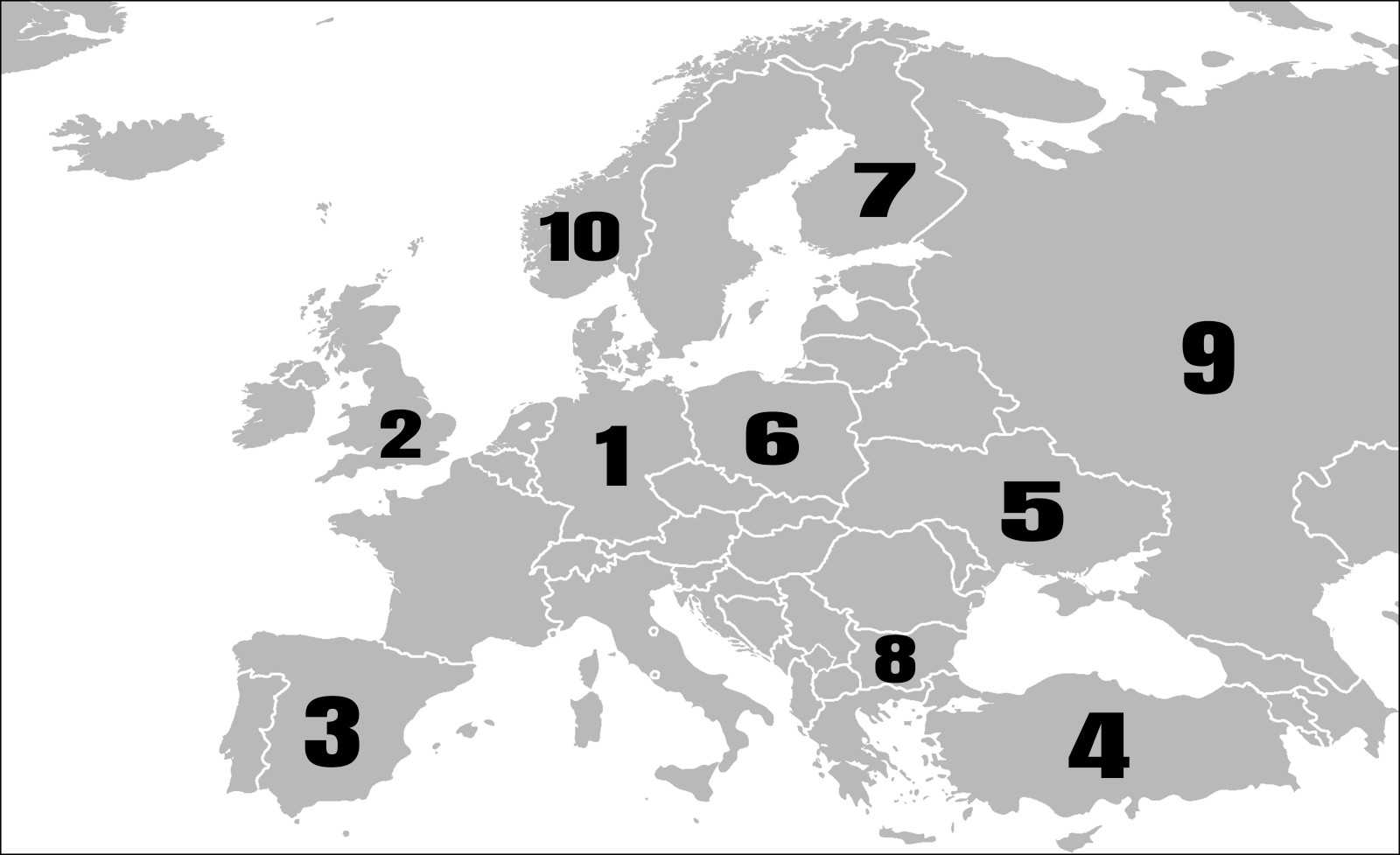
Match each river to the country it is chiefly associated with.
Click on image to zoom
GlommaKızılırmak SpreeKemijokiEbroVistulaIskarLenaDnieperTrent* Drag / drop or click on the choices above to move them to the answer list. View Image Attributions for This Quiz
The Spree River is a significant waterway in eastern Germany and a small part of the Czech Republic, stretching about 400 kilometres (250 miles) in length. It originates in the Lusatian Highlands near the Czech border and flows northward through towns such as Bautzen, Spremberg, and Cottbus.
In Berlin, the Spree is a central feature of the city's landscape and culture, winding through its heart and passing landmarks such as the Berlin Cathedral, the Reichstag building, and Museum Island, a UNESCO World Heritage Site home to several major museums.
The river is a popular site for recreational activities, such as boat tours, with scenic views and connecting various parts of the city through more than 50 bridges, including the picturesque Oberbaum Bridge.
2. Trent
The River Trent is the third longest river in the United Kingdom, flowing about 298 kilometres (185 miles) from its source near Biddulph Moor in Staffordshire through the English Midlands. It passes through towns and cities such as Stoke-on-Trent, Burton upon Trent, and Nottingham before joining the River Ouse at Trent Falls to form the Humber Estuary, which flows into the North Sea.
For centuries, the River Trent was integral to regional transport and economic exchange, with canals like the Foss Dyke and the Sheffield and South Yorkshire Navigation still in use today. Although a lot of commercial usage has declined, bulk oil is still transported upstream from Hull.
The Trent is also known for frequent flooding, which has shaped its course and the surrounding landscape over time. The name 'Trent' likely derives from Romano-British roots meaning 'strongly flooding' or 'trespasser', reflecting its tendency to overflow its banks.
3. Ebro
The Ebro River is the longest entirely within Spain, stretching approximately 930 to 987 kilometres (around 580 to 615 miles) from its source in the Cantabrian Mountains in northern Spain at Fontibre. It flows east-southeastward through multiple regions, including Cantabria, La Rioja, Navarre, Aragon, and Catalonia, before emptying into the Mediterranean Sea.
The Ebro is vital for its significant agricultural irrigation, hydroelectric power generation, and ecological importance, especially for the wetlands and diverse species in its delta.
It supports major cities such as Zaragoza and flows through landscapes ranging from gorges to wide valleys and fertile plains. The delta area is one of the largest wetlands in the western Mediterranean and is recognised for its natural habitats.
4. Kızılırmak
The Kızılırmak River is the longest river that flows entirely within Turkey (Türkiye). It begins in the eastern part of the country near the city of Sivas and winds its way through central Anatolia, passing towns like Kayseri and Kırşehir. It travels more than 1,300 kilometres (842 miles) before reaching the Black Sea.
Its name means 'Red River' in Turkish, and in ancient times, it was called the Halys River. Long ago, it marked the boundary between the powerful ancient kingdoms of Lydia and the Median Empire.
The Kızılırmak is important for farming and nature. People use its water to grow crops like wheat and sugar beets, and it helps fill lakes and wetlands that are home to birds and fish. Although dams have changed parts of its flow, the river still supports many communities and ecosystems.
5. Dnieper
The Dnieper River, also known as the Dnipro, is one of the major rivers of Europe, stretching approximately 2,200 to 2,285 kilometres (around 1,370 to 1,420 miles). It begins in the Valdai Hills in Russia and flows through Belarus and Ukraine before emptying into the Black Sea.
It is the fourth-longest river in Europe, with a catchment area of about 504,000 square kilometres. It passes through key cities in Ukraine, including Kyiv and Dnipro, and historically served as a vital waterway for trade and settlement, particularly in the ancient Kyivan Rus' state.
The river has a significant role in hydroelectric power production with several dams and reservoirs built along its course. It covers nearly half of Ukraine, linking many natural zones and supporting agriculture, transportation, and industry in the regions it flows through.
6. Vistula
The Vistula River is the longest river in Poland and the ninth longest in Europe, stretching approximately 1,047 kilometres (651 miles). It springs from the western slope of Barania Góra Mountain in the Silesian Beskids at an altitude of about 1,106 meters.
The river flows entirely within Poland, passing through major cities such as Kraków, Warsaw, and Toruń before emptying into the Baltic Sea near the Gdańsk Bay. The area it covers is around 194,424 square kilometres with numerous tributaries, making it a crucial waterway for Poland's geography, economy, and culture.
It forms a delta called Żuławy near its mouth, splitting into multiple branches, including the Nogat. The Vistula has been significant for trade, settlement, and agriculture, and it remains an important cultural symbol of Poland.
7. Kemijoki
The Kemijoki, or Kemi River, is the longest river in Finland, flowing approximately 550 kilometres (about 340 miles) from its source near the Finnish-Russian border through northern Finland to the Gulf of Bothnia at the city of Kemi. Along its path, it travels through key towns such as Kemijärvi and Rovaniemi.
The Kemijoki is vital for Finland's hydroelectric power production, with around 15 power plants installed along its course, producing roughly a third of the country's hydroelectric energy. Though the river's natural rapids have been submerged by these dams, it remains important for fishing and recreation, with species like salmon and trout living in its waters.
The river's basin covers about 51,000 square kilometres, encompassing a significant part of northern Finland's ecosystem, including national parks and wildlife reserves.
8. Iskar
The Iskar River is the longest river flowing entirely within Bulgaria, with a length of 368 kilometres (229 miles). Its source is three main forks in the Rila Mountains, Bulgaria's highest mountain range, and it flows northward through the country before joining the Danube River.
Along its course, the Iskar passes through several provinces including Sofia, Sofia City, Vratsa, Lovech, and Pleven, and it crosses major geographical features such as the Sofia Valley and the Balkan Mountains. One of the river's highlights is the spectacular Iskar Gorge in the Balkan Mountains, known for its steep slopes and scenic beauty.
The Iskar is important economically and environmentally, supplying water for the capital city Sofia, providing irrigation, generating hydroelectric power, and supporting local ecosystems with over 50 fish species. It also forms the largest artificial lake in Bulgaria.
9. Lena
The Lena River is one of the longest rivers in the world and the longest wholly within Russia, stretching about 4,294 kilometres (2,668 miles). It starts in the Baikal Mountains near Lake Baikal in Siberia and flows generally northward through eastern Siberia to empty into the Laptev Sea, a part of the Arctic Ocean.
Its area is vast, covering roughly 2.49 million square kilometres, and it's primarily underlain by permafrost. It is navigable for about 3,540 kilometres and features a large delta spanning roughly 30,000 square kilometres that contains numerous channels and islands.
The Lena Basin supports diverse ecosystems, containing forests and wetlands, and is home to various indigenous peoples such as the Sakha. It is also rich in natural resources including coal, natural gas, gold, and diamonds.
10. Glomma
The Glomma River, also known as Glåma, is Norway's longest and most voluminous river, stretching approximately 621 kilometres (386 miles). Originating from a series of small lakes and streams that drain into Lake Aursunden in the Trøndelag region near the Swedish border, it flows southward through eastern Norway.
It passes through Østerdalen valley, then continues through various towns such as Kongsvinger before reaching Lake Øyeren and emptying into the Oslofjord near the city of Fredrikstad. The river's basin covers about 42,000 square kilometres, roughly 13% of Norway's land area.
The Glomma is important for its role in Norway's timber industry, as it flows through some of the country's richest forest districts and has been a key route for log floating. It also supports hydroelectric power production through several dams and power plants along its course. Ecologically, it sustains a variety of fish species, including salmon and trout, making it a popular destination for fishing.
This quiz was reviewed by FunTrivia editor agony before going online.
Any errors found in FunTrivia content are routinely corrected through our feedback system.