FREE! Click here to Join FunTrivia. Thousands of games, quizzes, and lots more!
Locating Greenland Trivia Quiz
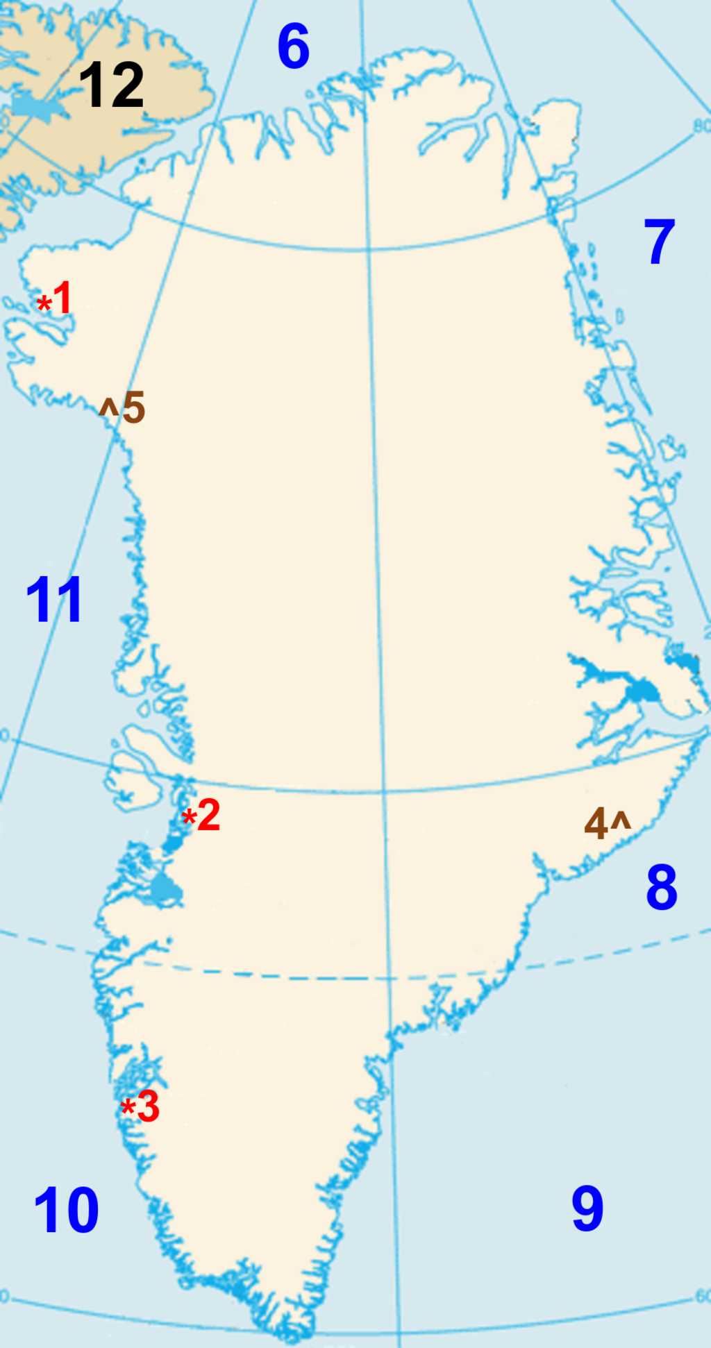
Located between North America and Europe, Greenland is an Arctic land of ice sheets, fjords, and remote wilderness. Can you identify its major settlements, natural landmarks, and surrounding waters on this map?
Last 3 plays: saradu (4/12), Alcoholic63 (3/12), pennie1478 (5/12).
Click on image to zoom
Baffin BayDenmark StraitLincoln SeaCanadaGreenland SeaNuukDavis StraitNorth Atlantic OceanKyst Nature ReserveIlulissatPituffik Space BaseGunnbjørn Fjeld* Drag / drop or click on the choices above to move them to the answer list. View Image Attributions for This Quiz
Pituffik Space Base (formerly Thule Air Base) is located in northwestern Greenland, approximately 1,200 km (750 mi) north of the Arctic Circle. It is the northernmost installation of the United States Space Force and occupies a strategic position between North America and Europe. In recent years, Greenland's location and natural resources have attracted increased international attention, including renewed interest from the United States as Arctic shipping routes become more accessible and great-power competition in the region intensifies.
Established during the Cold War in 1951, the base became an important component of North American defence. Its location allows it to monitor ballistic missile launches and track satellites orbiting above the Arctic. The base also supports communications, scientific research, and space surveillance operations. Its radar systems form part of the missile warning network that helps defend North America.
In 2023, the installation was renamed from Thule Air Base to Pituffik Space Base, adopting the traditional Greenlandic name for the area. The change was made both to better reflect the base's role within the United States Space Force and to recognize its connection to Greenlandic culture and history.
2. Ilulissat
Ilulissat is Greenland's third-largest settlement and is located on the island's west coast, about 350 km (220 mi) north of the Arctic Circle. The town was known as Jakobshavn during much of the Danish colonial period; today, Ilulissat is its official name, and the Greenlandic word means "icebergs."
The town is best known for Ilulissat Icefjord, a UNESCO World Heritage Site. The nearby Sermeq Kujalleq (formerly known internationally as the Jakobshavn Glacier) is one of the fastest-moving glaciers in the world and produces enormous icebergs that drift through Disko Bay. The glacier has also become one of the world's most closely studied examples of ice loss, as warming temperatures have accelerated the retreat of many of Greenland's outlet glaciers.
Fishing, particularly for halibut and shrimp, remains the backbone of the local economy. Tourism is also a major industry, with visitors coming to see the icefjord, nearby glaciers, whales, and the northern lights.
3. Nuuk
Nuuk is the capital and largest city of Greenland, situated on the island's southwestern coast near the mouth of Nuup Kangerlua, one of the world's largest fjord systems. Although Greenland covers more than two million square kilometers, Nuuk has a population of only around 20,000 people.
Founded in 1728 by Danish missionary Hans Egede, Nuuk was known for many years by its Danish name, Godthåb ("Good Hope"). It serves as Greenland's political, cultural, and economic center and is home to the Inatsisartut (Greenlandic Parliament), the national university, and numerous museums and cultural institutions.
Nuuk has grown rapidly in recent decades and today contains nearly one-third of Greenland's population. Despite its modern development, the city remains closely connected to Greenland's Inuit heritage. Like the rest of Greenland, Nuuk is experiencing the effects of a warming Arctic, including changes to sea ice conditions, fisheries, and transportation.
4. Gunnbjørn Fjeld
Gunnbjørn Fjeld is the highest mountain in Greenland and the highest point in the Arctic, reaching an elevation of 3,694 m (12,119 ft). It is located in the Watkins Range near Greenland's southeastern coast.
Named after the Norse explorer Gunnbjørn Ulfsson, who may have been the first European to sight Greenland, the mountain remains remote and difficult to access. Most climbers arrive by ski-equipped aircraft and then cross glaciers on their way to the summit.
Although not technically difficult by mountaineering standards, Gunnbjørn Fjeld's harsh Arctic weather and isolation make it a challenging expedition. From its summit, climbers can see glaciers and mountain ranges stretching across southeastern Greenland, a region where scientists have documented significant glacial retreat in recent decades.
5. Kyst Nature Reserve
Often identified on maps as part of the vast protected region of northeastern Greenland, this area lies within Northeast Greenland National Park, which covers approximately 972,000 km² (375,000 sq mi) and is the largest national park in the world.
The park occupies much of northeastern Greenland. There are no permanent civilian settlements within its borders, and human activity is mostly limited to scientific research stations and military patrols.
Wildlife found in the park includes polar bears, musk oxen, Arctic foxes, walruses, and numerous seabirds. Because there is very little human activity in the region, scientists use it to study Arctic wildlife, glaciers, and climate change.
6. Lincoln Sea
The Lincoln Sea is a section of the Arctic Ocean located north of Greenland and Canada's Ellesmere Island. It is among the northernmost bodies of water on Earth.
The sea remains covered by thick pack ice for much of the year and contains some of the oldest and most durable sea ice in the Arctic. These conditions make navigation extremely difficult, even during the summer months.
Scientists closely monitor the Lincoln Sea because changes in its ice cover provide important information about Arctic climate trends. Although it still contains some of the Arctic's oldest sea ice, researchers have recorded significant declines in both the extent and thickness of that ice in recent decades.
7. Greenland Sea
The Greenland Sea lies between Greenland to the west, Iceland to the south, and the Norwegian archipelago of Svalbard to the east. It forms part of the Arctic Ocean and serves as a connection to the North Atlantic.
This sea plays a critical role in global ocean circulation. Cold, dense water sinks here and contributes to the system of ocean currents that helps regulate climate throughout the North Atlantic region.
The Greenland Sea supports rich marine ecosystems that include seals, whales, fish, and seabirds. Historically, it was also an important area for Arctic exploration and commercial whaling expeditions.
8. Denmark Strait
The Denmark Strait is the narrow body of water separating Greenland from Iceland. It connects the Greenland Sea in the north to the North Atlantic Ocean in the south.
One of the strait's most remarkable features is the Denmark Strait cataract, the world's largest known underwater waterfall. Deep beneath the surface, dense cold water plunges thousands of meters along the seafloor.
Historically, the strait has been an important maritime route linking the North Atlantic and Arctic regions. It also serves as a migration corridor for whales and other marine animals traveling between the two oceans.
9. North Atlantic Ocean
The North Atlantic Ocean borders southern Greenland and separates North America from Europe and Africa. It is one of the world's most important oceans for international trade, transportation, and communication.
For Greenland, the North Atlantic provides access to shipping routes that connect the island with Europe and North America. The ocean also supports valuable fisheries, which have long been an essential part of Greenland's economy.
Ocean currents such as the Gulf Stream influence weather and climate across the North Atlantic region. These currents help moderate temperatures in northern Europe and affect marine ecosystems throughout the basin. Scientists also monitor the North Atlantic closely because increasing meltwater from Greenland's ice sheet may influence ocean circulation patterns in the future.
10. Davis Strait
The Davis Strait lies between western Greenland and Canada's Baffin Island. It connects Baffin Bay in the north with the Labrador Sea in the south.
Named after English explorer John Davis, who sailed through the region in the sixteenth century, the strait has long been important for Arctic exploration and maritime navigation.
The waters of the Davis Strait are rich in marine life, including whales, seals, and fish species that support local fishing industries. Icebergs drifting south from Greenland's glaciers are also a common sight throughout much of the year.
11. Baffin Bay
Baffin Bay is located between Greenland and Canada's Baffin Island. Covering approximately 689,000 km² (266,000 sq mi), it forms one of the major waterways connecting the Arctic Ocean with the North Atlantic.
The bay is known for its cold waters, extensive sea ice, and impressive iceberg populations. Many of the icebergs that eventually reach the North Atlantic pass through Baffin Bay on their journey southward.
Wildlife thrives in the region, with narwhals, beluga whales, bowhead whales, seals, and polar bears inhabiting its waters and coastlines. As Arctic sea ice declines, Baffin Bay has become increasingly important for scientific research, while longer ice-free seasons may eventually lead to greater commercial shipping activity in the region.
12. Canada
The Canadian landmass closest to Greenland is Ellesmere Island, part of the territory of Nunavut. In some locations, Greenland and Canada are separated by only a few dozen kilometers of water through Nares Strait and related channels.
Ellesmere Island is Canada's northernmost large island and the third-largest island in the country. Like northern Greenland, it features rugged mountains, glaciers, fjords, and polar desert landscapes.
The narrow waterways between Greenland and Ellesmere Island have attracted explorers for centuries and today form part of the boundary between Canada and Greenland.
This quiz was reviewed by FunTrivia editor agony before going online.
Any errors found in FunTrivia content are routinely corrected through our feedback system.