FREE! Click here to Join FunTrivia. Thousands of games, quizzes, and lots more!
Quiz about Perilous Straits and Unsafe Passages

Perilous Straits and Unsafe Passages Quiz


Straits play a vital role in maritime traffic. As recent news have evidenced, any disruption of these waterways can have serious global consequences. This quiz will explore some of the world's major maritime choke points.

A photo quiz by LadyNym. Estimated time: 3 mins.
  1. Home
  2. »
  3. Quizzes
  4. »
  5. Geography Trivia
  6. »
  7. Bodies of Water
  8. »
  9. Bodies of Water Photo Quizzes

Author
LadyNym
Time
3 mins
Type
Photo Quiz
Quiz #
425,496
Updated
Sep 29 26
# Qns
10
Difficulty
New Game
Plays
10
Last 3 plays: Reamar42 (8/10), Guest 74 (9/10), Guest 171 (6/10).
-
Question 1 of 10
1. Due to the US-Iran war, the Strait of Hormuz has become a household name. What country - one of the world's few remaining sultanates - lies on the southern side of the strait, opposite the coast of Iran? Hint


Question 2 of 10
2. The strait of Bab al-Mandab is a narrow waterway between the continents of Africa and Asia. What is the rather depressing meaning of its Arabic name? Hint


Question 3 of 10
3. One of the world's most important shipping lanes, the Strait of Malacca connects the Indian and Pacific Oceans. What is the biggest threat to ships travelling through this waterway? Hint


Question 4 of 10
4. The Taiwan Strait lies in a strategic position between mainland China and the island once known as Formosa. Taiwan's main seaport, one of the world's busiest, is located on the eastern coast of the strait. What is its name? Hint


Question 5 of 10
5. Another economically significant sea passage, the Korea Strait has also had a prominent role in history. What is the name of the island that lies in the middle of the strait, where a major naval battle was fought by Russia and Japan in 1905? Hint


Question 6 of 10
6. Three of these waterways lead from the Caribbean Sea to the Atlantic Ocean or the Gulf of Mexico. Which one, located much further south, connects the Atlantic with the Pacific Ocean? Hint


Question 7 of 10
7. Though not a strait, the Cape of Good Hope is frequently counted as one of the major maritime choke points because of its role as the world's primary bypass route.


Question 8 of 10
8. Once believed to be the end of the known world, the Strait of Gibraltar separates Europe from Africa. What Spanish autonomous city, located on the southern side of the strait, was the scene of migrant-related unrest in the summer of 2026? Hint


Question 9 of 10
9. The Dardanelles and the Bosporus are known collectively as the Turkish Straits. Which marginal sea lies between them? Hint


Question 10 of 10
10. Which two cities are linked by a bridge that spans the Öresund, one of the straits connecting the North Sea with the Baltic Sea?


(Optional) Create a Free FunTrivia ID to save the points you are about to earn:

arrow Select a User ID:
arrow Choose a Password:
arrow Your Email:


View Image Attributions for This Quiz

Most Recent Scores
Today : Reamar42: 8/10
Today : Guest 74: 9/10
Today : Guest 171: 6/10
Today : xchasbox: 9/10
Today : Guest 97: 5/10
Today : Guest 172: 8/10
Today : mazza47: 10/10
Today : xxFruitcakexx: 8/10
Today : PosterMeerkat: 7/10

Quiz Answer Key and Fun Facts
1. Due to the US-Iran war, the Strait of Hormuz has become a household name. What country - one of the world's few remaining sultanates - lies on the southern side of the strait, opposite the coast of Iran?

Answer: Oman

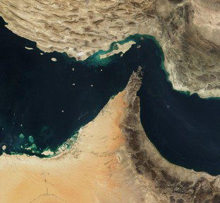
Probably named after Ahura Mazda, the supreme deity in Zoroastrianism, the Strait of Hormuz (pictured in the cover photo) lies between the southwestern coast of Iran and the Musandam Governorate, an Omani exclave separated from the main body of the country by the United Arab Emirates. The strait is about 167 km (104 mi) long, about 97 km (60 mi) wide at its widest point and 39 km (24 mi) at its narrowest. Several islands lie within the Strait of Hormuz, notably Qeshm, the largest island in the Persian Gulf.

Known since antiquity, from the late 15th century the Strait of Hormuz became strategically important for European powers vying for military dominance in the Gulf region. As it provides the only maritime access to the Indian Ocean for most Gulf countries (except Iran and Saudi Arabia), it plays a crucial role in the transport of oil and gas towards Europe and Asia. Due to the sheer volume of the traffic passing through the strait, a traffic separation scheme has been implemented, with separate lanes for inbound and outbound ships.

Iran's repeated threats to close the strait never came to fruition until the war that broke out between the Islamic Republic and the USA and Israel on 28 February 2026. The Strait of Hormuz crisis has severely disrupted international trade and caused energy prices to skyrocket in many parts of the world, especially Europe and Asia. However, smugglers in small speedboats still ply their illicit trade between the Iranian coast and the city of Khasab (shown in the photo) at the tip of the Musandam Peninsula.
2. The strait of Bab al-Mandab is a narrow waterway between the continents of Africa and Asia. What is the rather depressing meaning of its Arabic name?

Answer: Gate of Tears

Prominently featured in the news for much of 2026, the strait of Bab al-Mandab lies between the countries of Yemen and Djibouti, separating the Arabian Peninsula from the Horn of Africa. Its name means "Gate of Grief" (sometimes also rendered as "Gate of Tears"). Though usually interpreted as a reference to the dangers of navigating this narrow body of water, which connects the Red Sea with the Gulf of Aden (an arm of the Indian Ocean), the name has also been associated with an Arab legend about the many people drowned when an earthquake broke Asia and Africa apart.

Bab al-Mandab is about 26 km (14 mi) wide between the peninsulas of Ras Siyyan (Djibouti) and Ras Menheli (Yemen). The island of Perim, which lies closer to the Yemeni coast, divides the strait into two channels: the eastern one, Bab Iskender, is quite shallow, while the western one, Dact-el-Mayun, is much deeper. Due to its location south of the Suez Canal, the strategic importance of the strait cannot be overstated. Though passage is tricky for large tankers because of the strait's narrowness, its closure would force ships into a costly and time-consuming detour around the southern tip of Africa to reach the Mediterranean Sea or other regions of Asia. In the summer of 2026, the Houthis - an Islamist militia group that controls much of Yemen - increased their threats against ships trying to transit through the Bab al-Mandab, particularly those from Israel and Saudi Arabia. As a countermeasure, the US has lifted sanctions against Eritrea, whose southern coast lies very close to the entrance of the strait.

Abode of Peace is the English translation of the Arabic name of Dar es Salaam, the former capital of Tanzania; Father of Deer is Abu Dhabi, the capital of the United Arab Emirates; Place of Winds is Nouakchott, the capital of Mauritania.
3. One of the world's most important shipping lanes, the Strait of Malacca connects the Indian and Pacific Oceans. What is the biggest threat to ships travelling through this waterway?

Answer: pirates

Named after the city of Malacca, the capital of the Malaysian state of the same name, the Strait of Malacca is a long and narrow sea passage lying between the Malay Peninsula to the northeast and the island of Sumatra (part of Indonesia) to the southwest. Connecting the Andaman Sea (Indian Ocean) with the South China Sea (Pacific Ocean), the strait is 900 km (560 mi) long, with a width ranging from 250 km (155 mi) in its northern part and 65 km (40 mi) in the south, near the city-state of Singapore.

As the world's ten busiest container ports are all located in Asia, it is easy to see how crucial the Strait of Malacca is for international maritime trade. Every year nearly 100,000 ships pass through the strait, carrying one-quarter of the world's traded goods - including the huge variety of manufactured products from China as well as fossil fuels, coffee and palm oil. Not surprisingly, that amount of traffic is a prime target for the pirates who are active in the region - a centuries-long tradition. Ensuring the security of the vessels in transit through the Strait of Malacca is thus a top priority for the countries that border it - Thailand, Malaysia, Singapore and Indonesia.

Another hazard for navigation is the haze from the wildfires that frequently rage in Sumatra, which forces ships to slow down. The remains of shipwrecks that have occurred in the shallow waters of the strait in the past 150 years also pose a collision risk.
4. The Taiwan Strait lies in a strategic position between mainland China and the island once known as Formosa. Taiwan's main seaport, one of the world's busiest, is located on the eastern coast of the strait. What is its name?

Answer: Kaohsiung

Connecting the South China and East China Seas, the Taiwan Strait is a 370-km (230 mi) long sea passage also known as the Fukien Strait or by the local name of Black Ditch. It runs between the west coast of Taiwan and the province of Fujian in southeast China. As straits go, it is reasonably wide - 126 km (78 mi) at its narrowest point and 410 km (250 mi) at its widest.
In the 20th century, the Taiwan Strait was involved in several instances of tension between the government of Taiwan (Republic of China) and the People's Republic of China, which claims the island as part of its territory. Though the situation has stabilized in recent times, Chinese ships often trespass into Taiwan's territorial waters and are intercepted by the island's Coast Guard Administration.

The world's 17th-busiest container port, Kaohsiung is the main economic hub of southern Taiwan - a bustling city home to over 2.7 million people. It is a major industrial and export centre that also attracts a considerable number of tourists with its shopping streets and malls, leisure parks and cultural and natural sights. Kaohsiung is part of the 21st-Century Maritime Silk Road, which runs from the Chinese coast to the port of Trieste on the Adriatic Sea.

The three wrong choices are also major Asian ports located in the Philippines (Manila), China (Guangzhou) and Japan (Yokohama).
5. Another economically significant sea passage, the Korea Strait has also had a prominent role in history. What is the name of the island that lies in the middle of the strait, where a major naval battle was fought by Russia and Japan in 1905?

Answer: Tsushima

The Korea Strait connects the Yellow Sea and the East China Sea with the Sea of Japan. It is split into two channels - the Western Channel and the Tsushima Strait - by the island of Tsushima, which lies between the Korean Peninsula and the Japanese islands of Kyushu and Honshu. The strait is about 200 km (120 mi) wide, with an average depth of 100 m (300 ft). Both Japan and South Korea allow free passage through the Korea Strait, which is a major shipping lane for goods bound for the ports of southern South Korea, especially Busan, one of the world's ten busiest container ports. Tsushima lies about 50 km (31 mi) from Busan.

Part of Japan's Nagasaki Prefecture, Tsushima Island has an elongated shape with a deep indentation in the middle, known as Asō Bay (shown in the photo). Notable for its flora and fauna, which include some endemic species, Tsushima is mountainous and thickly forested. Connected to Busan by a high-speed ferry service, the island is a popular destination for South Korean tourists.

The Battle of Tsushima, fought on 27-28 May 1905 in Tsushima Strait, was the final naval confrontation of the Russo-Japanese War. The Imperial Russian fleet was almost destroyed by the Japanese. Centuries before that, the Korea Strait witnessed the failure of Kublai Khan's Mongols to conquer Japan in 1271 and 1284. On both instances, the Mongol fleet was destroyed by typhoon winds that became known as "kamikaze" (divine wind).

Of the three islands listed as wrong answers, Okinawa is also part of Japan, while Mindoro is part of the Philippines and Komodo of Indonesia.
6. Three of these waterways lead from the Caribbean Sea to the Atlantic Ocean or the Gulf of Mexico. Which one, located much further south, connects the Atlantic with the Pacific Ocean?

Answer: Beagle Channel

Named after the ship that later became famous for Charles Darwin's ground-breaking voyage, the Beagle Channel is located at the southern tip of South America. The waterway, shared by Chile and Argentina, separates the main island of the Tierra del Fuego archipelago from various smaller islands. About 240 km (150 mi) long and 5 km (3 mi) wide at its narrowest point, it is the shortest of three navigable passages around the South American continent - the others being the Straits of Magellan and the Drake Passage. Two of the world's southernmost cities, Puerto Williams (Chile) and Ushuaia (Argentina), are located on the Beagle Channel.

Unlike the three sea passages listed as wrong options, the Beagle Channel is not a significant shipping lane. Much of the maritime traffic in the waterway consists of cruise ships or freight lines bound for local settlements or ports such as Valparaíso and Punta Arenas (Chile) or Buenos Aires (Argentina).

The Windward and Mona Passages run on either side of the island of Hispaniola, connecting the Caribbean Sea with the Atlantic Ocean. The former, which lies on a direct shipping path from the Panama Canal to the US East Coast, separates Cuba from Haiti. The Mona Passage, known for seismic activity and variable tidal currents, separates the Dominican Republic from Puerto Rico. The Yucatán Channel lies between the Yucatán Peninsula in Mexico and western Cuba, connecting the Caribbean Sea with the Gulf of Mexico.
7. Though not a strait, the Cape of Good Hope is frequently counted as one of the major maritime choke points because of its role as the world's primary bypass route.

Answer: True

The Cape of Good Hope is a rocky headland at the southern tip of the Cape Peninsula, on the Atlantic coast of South Africa. Originally named Cape of Storms by Portuguese explorer Bartolomeu Dias, it was given its current name by King John II of Portugal to signal the optimism engendered by the opening of a new sea route to the East. The European-Asian sea route first completed by Vasco da Gama in 1498 is commonly known as the Cape Route because of the headland's iconic status.

Though the opening of the Suez Canal in 1869 made the Cape Route partially obsolete, it has not been completely abandoned for several reasons. Some ships, mainly tankers, are too large to pass through the Suez Canal: they are referred to as Capesize and must use the Cape Route. While the opening of the New Suez Canal in 2015 has increased the maximum size (Suezmax) of ships allowed through the Canal, the Cape Route remains an important alternative route in case of disruptions - as in the well-known blockage of the Suez Canal by the Taiwanese cargo ship "Ever Given" in March 2021. Another reason for ships to use the Cape Route is to avoid the fees that need to be paid for crossing the Canal.

The conflict that broke out in February 2026, pitting the US and Israel against Iran, has once again made the Cape Route a viable alternative - especially in the light of threats to close the strait of Bab al-Mandab, which connects the Indian Ocean with the Red Sea. However, taking the Cape Route adds at least two weeks to the journey and significantly increases shipping costs.
8. Once believed to be the end of the known world, the Strait of Gibraltar separates Europe from Africa. What Spanish autonomous city, located on the southern side of the strait, was the scene of migrant-related unrest in the summer of 2026?

Answer: Ceuta

The Strait of Gibraltar may very well be the world's most famous strait because of the legends attached to it. The narrow waterway that lies between the continents of Europe and Africa, connecting the Mediterranean Sea with the Atlantic Ocean, was once known as the Pillars of Hercules, on which it was said to be inscribed a warning to "go no further" ("Ne plus ultra" in Latin). Its current name stems from the Rock of Gibraltar that dominates the entrance to the strait on the northern side; its Arab name, Bab el-Maghrib, means Gate of the West.

The Strait of Gibraltar is very narrow (14.2 km/8.9 mi at its narrowest) though its waters are very deep. It is bounded by southern Spain and the British territory of Gibraltar to the north, and Morocco and the autonomous Spanish city of Ceuta to the south. Regular ferry services connect the two sides of the strait, whose importance does not only lie in its role as a shipping lane. In fact, surface water from the Atlantic Ocean flows through it into the Mediterranean Sea, keeping the latter's salinity down.

At the end of July 2026, thousands of migrants breached the border with Morocco at Ceuta, overwhelming the city's facilities; at least 72 people died in the attempt. As the city's sovereignty has been long disputed by Morocco, there have been allegations that the event may have been engineered by the Moroccan government to put pressure on Spain.

Of the three cities listed as wrong options, Cádiz and Málaga are in southern Spain (Andalusia), while Tangier is in northwestern Morocco.
9. The Dardanelles and the Bosporus are known collectively as the Turkish Straits. Which marginal sea lies between them?

Answer: Sea of Marmara

The Turkish Straits provide the only access to the Black Sea, which is bordered by Bulgaria, Romania, Ukraine, Russia, Georgia and Turkey, from the Mediterranean Sea. Because of their location, the straits are regarded as one of the boundaries between Europe and Asia; they also divide the European part of Turkey (Eastern Thrace) from Asian Turkey (Anatolia). The Dardanelles (called Çanakkale Strait in Turkish) connects the Aegean Sea with the Sea of Marmara, while the Bosporus (Istanbul Strait) connects the latter with the Black Sea. The Sea of Marmara (from the Greek word for marble) is considered the smallest sea in the world.

Known in antiquity as Hellespont, the Dardanelles (from Dardanus, a mythical son of Zeus) is 68 km (42 mi) long and 1.2 km (0.75 mi) wide. The Gallipoli Peninsula, known for its role in WWI, lies on its western side; the city of Çanakkale on the eastern side is located near the archaeological site of Troy. The strait is spanned by the Çanakkale 1915 Bridge, the world's longest suspension bridge. The Bosporus ("cattle passage" in Greek) is 30 km (19 mi) long and only 700 m (2,300 ft) wide: it is spanned by three suspension bridges, the most recent of which - Yavuz Sultan Selim Bridge (opened in 2016) - is shown in the photo.

Due to their strategic importance, the Turkish Straits have been at the centre of many diplomatic debates, as well as plans to seize control of them. Access is now regulated by the 1936 Monreux Convention Regarding the Regime of the Straits, which poses strict limitations on the access of warships to the Black Sea in peacetime. In accordance with the Convention, the Dardanelles were closed to all foreign warships at the beginning of the Russian invasion of Ukraine of February 2022.
10. Which two cities are linked by a bridge that spans the Öresund, one of the straits connecting the North Sea with the Baltic Sea?

Answer: Copenhagen and Malmö

A series of sea passages known collectively as the Danish Straits connect the Skagerrak and the Kattegat, both arms of the North Sea, with the Baltic Sea. Most of these straits wind their way through the islands that form part of the territory of Denmark. However, the narrowest of them, the Öresund ("gravel strait" in Swedish, Danish and Norwegian) separates the island of Zeeland from the province of Scania in southwestern Sweden. The Danish capital, Copenhagen, lies on the eastern coast of Zeeland, facing Malmö, Sweden's third-largest city, across the strait.

The Öresund is 118 km (73 mi) long; its width ranges from 28 km (17 mi) to 4 km (2.5 mi). Its narrowest point lies between Helsingborg (Sweden) and Helsingřr (Denmark) - the latter known in English as Elsinore, the setting of Shakespeare's "Hamlet". Opened on 1 July 2000, the Öresund Bridge (shown in the photo with festive lighting) runs for nearly 8 km (5 mi) from the Swedish coast to the artificial island of Peberholm, which is connected to the island of Amager (part of the Copenhagen metro area) by a 4-km (2.5 mi) tunnel.

The Danish Straits share with the Turkish Straits and the Strait of Hormuz the dubious distinction of offering no alternative sea route in case of blockage. Though the region in which the Öresund is located is a very stable and peaceful one, accidents or weather events can effectively block the passage of trade goods to and from the North Sea and the Atlantic Ocean to the Baltic Sea and the countries that border it.
Source: Author LadyNym

This quiz was reviewed by FunTrivia editor agony before going online.
Any errors found in FunTrivia content are routinely corrected through our feedback system.
9/29/2026, Copyright 2026 FunTrivia, Inc. - Report an Error / Contact Us