FREE! Click here to Join FunTrivia. Thousands of games, quizzes, and lots more!
Quiz about So Thats Where It Is

So That's Where It Is! Trivia Quiz


There are a lot of seas and oceans on our globe, many of which you may have heard of without knowing exactly where they are. Let's find out.

A photo quiz by looney_tunes. Estimated time: 4 mins.
  1. Home
  2. »
  3. Quizzes
  4. »
  5. Geography Trivia
  6. »
  7. Bodies of Water
  8. »
  9. Bodies of Water Photo Quizzes

Author
looney_tunes
Time
4 mins
Type
Photo Quiz
Quiz #
345,100
Updated
Jun 05 23
# Qns
10
Difficulty
Average
Avg Score
8 / 10
Plays
14639
Awards
Top 5% quiz!
Last 3 plays: Guest 82 (5/10), HumblePie7 (6/10), gumman (7/10).
-
Question 1 of 10
1. We'll start our tour in this ocean which is the top of the heap - at least, if you look at the globe in its accepted orientation. What is the name of the ocean that surrounds the vicinity of the North Pole? Hint


Question 2 of 10
2. We try harder - the old Avis advertising slogan could be applied to the second-largest of the world's oceans, which separates Europe and Africa from North and South America. What is the name of the ocean we are visiting now? Hint


Question 3 of 10
3. Ahoy, me hearties, we have arrived at a sea which lies to the southeast of the Gulf of Mexico, and was named for one of the indigenous tribes of the area. Which of these seas, known both as a vacation spot and as a pirate haven, are we visiting now? Hint


Question 4 of 10
4. Our next stop takes us well south. Which of these is NOT a name commonly used to describe the ocean that surrounds the continent of Antarctica? Hint


Question 5 of 10
5. The name of the next ocean on our trip would not lead one to expect that it is surrounded by the Ring of Fire, a region of intense tectonic activity leading to numerous volcanoes and frequent earthquakes. Which ocean is surrounded by the infamous Ring of Fire? Hint


Question 6 of 10
6. The Bering Sea is connected to the Arctic Ocean by the Bering Strait. Which country might we be visiting if we are looking out over the Bering Sea? Hint


Question 7 of 10
7. This sea off the east coast of China is the subject of territorial disputes between the People's Republic of China, Japan and South Korea, all of which border it (although Korea is not shown in this map - it lies just to the north of the region shown). Which contentious sea are we cruising through now? Hint


Question 8 of 10
8. The next leg of our trip takes us to the Tasman Sea, lying between Australia and New Zealand, which was named after Abel Tasman, the first European to record visiting New Zealand and Tasmania (guess who they named that island after). What was his nationality? Hint


Question 9 of 10
9. Some of the world's best-known islands are located in an ocean that extends from Africa to Australia, and lies south of mainland Asia. In what ocean will our cruise ship allow us to visit Madagascar and Sri Lanka, among other islands? Hint


Question 10 of 10
10. Moses parted its waters, according to tradition; the Suez Canal connected it to the Mediterranean Sea in 1869; the Sinai Peninsula lies at its northern end. What is the name of the last sea we will visit on our world tour, a sea that ancient geographers sometimes also referred to as the Arabian Gulf or the Sea of Mecca? Hint


(Optional) Create a Free FunTrivia ID to save the points you are about to earn:

arrow Select a User ID:
arrow Choose a Password:
arrow Your Email:


View Image Attributions for This Quiz

Most Recent Scores
Apr 18 2024 : Guest 82: 5/10
Apr 13 2024 : HumblePie7: 6/10
Apr 11 2024 : gumman: 7/10
Apr 09 2024 : turtle52: 9/10
Apr 03 2024 : tiye: 8/10
Mar 24 2024 : 173Kraut: 8/10
Mar 23 2024 : hilhanes: 8/10
Mar 23 2024 : Guest 91: 10/10
Mar 23 2024 : Samoyed7: 8/10

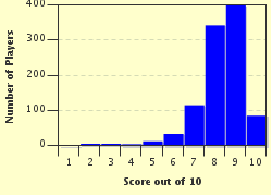
Score Distribution

quiz
Quiz Answer Key and Fun Facts
1. We'll start our tour in this ocean which is the top of the heap - at least, if you look at the globe in its accepted orientation. What is the name of the ocean that surrounds the vicinity of the North Pole?

Answer: Arctic Ocean

The Arctic Ocean is the smallest of the earth's oceans, and is mostly covered in ice for much of the year. Of course, there are those who consider that all the traditional oceans are part of one large ocean, usually referred to as the Global Ocean, and that this is just one of the many seas into which it can be divided. Sea is a term used to describe a specific smaller part of an ocean.

The Arctic Ocean has land boundaries with Canada, the United States of America, Russia, Norway, Iceland and Greenland, although some authorities place the last two within the Arctic Ocean rather than on its boundary.
2. We try harder - the old Avis advertising slogan could be applied to the second-largest of the world's oceans, which separates Europe and Africa from North and South America. What is the name of the ocean we are visiting now?

Answer: Atlantic Ocean

The Atlantic Ocean is still growing in size, due to spreading of about 2.5 cm (1 in) a year along the mid-Atlantic ridge. This is a mountainous region of divergent tectonic plates - in the northern hemisphere the Eurasian and North American plates are moving apart; in the southern hemisphere the African and South American plates are the culprits.

The island of Iceland is part of this ridge. The new magma that forms the increased crustal material actually surfaces along a trench in the middle of the ridge.
3. Ahoy, me hearties, we have arrived at a sea which lies to the southeast of the Gulf of Mexico, and was named for one of the indigenous tribes of the area. Which of these seas, known both as a vacation spot and as a pirate haven, are we visiting now?

Answer: Caribbean Sea

While all of these groups were to be found in the Caribbean or on nearby mainland areas, it was the Caribs whose name was used to identify this sea in English. The Caribbean Sea is also called the Sea of the Antilles in some languages, the Greater and Lesser Antilles being the island groups which define the northern and eastern edges of the Caribbean. Because of its location, many of the hurricanes that develop in the Atlantic Ocean pass through the Caribbean on their way to a continental landfall.
4. Our next stop takes us well south. Which of these is NOT a name commonly used to describe the ocean that surrounds the continent of Antarctica?

Answer: Equatorial Ocean

The Southern Ocean connects the southern parts of the Atlantic, Pacific and Indian Oceans. It is arbitrarily defined as the oceanic region south of the 60 degree latitude. Although it has a large perimeter, most of the region is the continent of Antarctica, so it is the second-smallest of the world's oceans.

This is the only ocean whose boundaries are not basically formed by land masses, and some geographers dispute the validity of calling it a separate ocean at all - it could be divided into three regions corresponding to the oceans immediately to its north at each point.

However, others argue that the ocean waters in this region behave sufficiently differently from the rest of the oceans, primarily due to their extreme cold and the strong circumpolar currents that make them more uniform than would be indicated by treating them separately, that the region should be considered independently and in its own right.
5. The name of the next ocean on our trip would not lead one to expect that it is surrounded by the Ring of Fire, a region of intense tectonic activity leading to numerous volcanoes and frequent earthquakes. Which ocean is surrounded by the infamous Ring of Fire?

Answer: Pacific Ocean

The Pacific Ocean is the largest of the world's oceans, lying between Asia and Australia on its west, and North and South America on its east. Its name was suggested by Ferdinand Magellan, who found its waters much calmer than those of the South Atlantic, especially the Straits of Magellan (modestly named after himself) which he had battled through to become the first European to travel from the Atlantic to the Pacific.

The Pacific Ring of Fire, which extends along the western coast of South America and North America, across the top of the Pacific through the Aleutian Islands, and down through the ocean off the east coast of Asia, turning east to pass north of Australia, then south again to include New Zealand.

This horseshoe-shaped region is the point of origin for about 90% of the world's earthquakes, because the Pacific Ocean is defined by a large number of tectonic plates that are undergoing subduction at its edges.

This means they are sliding under the continental plates they meet, with consequent stress and predictable results.
6. The Bering Sea is connected to the Arctic Ocean by the Bering Strait. Which country might we be visiting if we are looking out over the Bering Sea?

Answer: United States or Russia

The Bering Sea is part of the north Pacific Ocean. Its southern boundary is determined by the Alaska Peninsula and its extension along an arc that passes through the Aleutian Islands. It is therefore bounded on the east by Alaska, part of the United States, and on the west by Siberia and the Kamchatka Peninsula, both parts of Russia. Zhemchug Canyon, the world's largest known submarine canyon, can be found in the Bering Sea.
7. This sea off the east coast of China is the subject of territorial disputes between the People's Republic of China, Japan and South Korea, all of which border it (although Korea is not shown in this map - it lies just to the north of the region shown). Which contentious sea are we cruising through now?

Answer: East China Sea

The East China Sea, which has also been known as the Sea of Korea, extends from the Yellow Sea in the north to the Taiwan Strait, which connects it to the South China Sea. It is bordered on the east by Japan, on the north by South Korea, on the west by the People's Republic of China (China), and on the south by the Republic of China (Taiwan).

The discovery of the Chunxiao gas field, part of which lies in China's territory and part of which lies in a region disputed between China and Japan, has led to the area hitting the headlines since the Chinese started producing oil and gas in 2006.
8. The next leg of our trip takes us to the Tasman Sea, lying between Australia and New Zealand, which was named after Abel Tasman, the first European to record visiting New Zealand and Tasmania (guess who they named that island after). What was his nationality?

Answer: Dutch

Abel Janszoon Tasman (1603-1659) visited Mauritius in the Indian Ocean, then headed east along the southern edge of Australia, where he ran into the island that he called Van Diemen's Land, in honor of the Governor-General of the Dutch East Indies. It was later renamed Tasmania, and is now the smallest state of Australia. Continuing east across the Tasman Sea because the prevailing winds made it difficult to head north as planned, he ran into the south island of New Zealand. (There does seem to be a lot of luck in these discoveries!)
9. Some of the world's best-known islands are located in an ocean that extends from Africa to Australia, and lies south of mainland Asia. In what ocean will our cruise ship allow us to visit Madagascar and Sri Lanka, among other islands?

Answer: Indian Ocean

The Indian Ocean also contains Seychelles, Comoros, Mauritius and the Maldives, some of the island nations whose names are most commonly seen in discussions of global warming - they are all very low, and in serious danger of disappearing with only a small rise in sea level.

The Indonesian archipelago, on the east, is sometimes included in the Indian Ocean, and sometimes considered to be the border. News stories surrounding the 2004 Boxing Day tsunami made many people more familiar than they had been with the names of the countries that border the Indian Ocean.

The originating earthquake occurred near the east of the ocean, off the coast of Sumatra; Indonesia, Thailand, Sri Lanka and India all suffered extensive damage and loss of life from the tsunami.
10. Moses parted its waters, according to tradition; the Suez Canal connected it to the Mediterranean Sea in 1869; the Sinai Peninsula lies at its northern end. What is the name of the last sea we will visit on our world tour, a sea that ancient geographers sometimes also referred to as the Arabian Gulf or the Sea of Mecca?

Answer: Red Sea

The Red Sea is an arm of the Indian Ocean which extends between the Mandab Strait (which connects it to the Gulf of Aden and thence to the main ocean) in the south to the Sinai Peninsula in the north. At the Sinai Peninsula, it splits to form the Gulf of Aqaba (the eastern fork) and the Gulf of Suez (the western fork, which leads to the Suez Canal). Its western land borders are with the African countries of Djibouti, Eritrea, Sudan and Egypt; its eastern borders are with Saudi Arabia and Yemen.

It is thought possible that the name Red Sea was used by the Romans to denote South Sea, as opposed to the Black Sea, or North Sea, at the eastern end of 'Mare Nostrum' (Our Sea, their name for the Mediterranean).
Source: Author looney_tunes

This quiz was reviewed by FunTrivia editor Pagiedamon before going online.
Any errors found in FunTrivia content are routinely corrected through our feedback system.
Related Quizzes
1. These Lakes & Rivers are a Big Deal! Very Easy
2. Unnatural Waters Average
3. Come Sail the Seas Very Easy
4. Water, Water Everywhere... Average
5. Lakes of the World Easier
6. Estuaries of the World Average
7. Beautiful Bays Easier
8. A Widening Gulf Easier
9. Taking the Plunge Easier
10. Bodies of Water Average
11. Water World Average
12. Water, Water Everywhere Average

4/19/2024, Copyright 2024 FunTrivia, Inc. - Report an Error / Contact Us