FREE! Click here to Join FunTrivia. Thousands of games, quizzes, and lots more!
Quiz about Aotearoa III  Te Wai Pounamu

Aotearoa III - Te Wai Pounamu Trivia Quiz


This is the third of three NZ quizzes. The subject is the South Island (Te Wai Pounamu). What do you know about places and things in the deepest, darkest southern end of the country? I hope you enjoy it!

A multiple-choice quiz by Capfka. Estimated time: 6 mins.
  1. Home
  2. »
  3. Quizzes
  4. »
  5. Geography Trivia
  6. »
  7. Pacific Islands
  8. »
  9. New Zealand

Author
Capfka
Time
6 mins
Type
Multiple Choice
Quiz #
248,735
Updated
Dec 19 22
# Qns
15
Difficulty
Tough
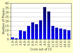
Avg Score
9 / 15
Plays
1644
Awards
Top 10% Quiz
Last 3 plays: rabbit1964 (2/15), PurpleComet (12/15), Guest 103 (9/15).
- -
Question 1 of 15
1. In 1642, Dutch explorer Abel Tasman's ships, the Heemskerck and the Zeehaen, dropped anchor in this bay located at 40deg 50' S, 191deg 30' E. The local Maori were distinctly unfriendly, and killed four sailors who were transferring between the two ships in a pinnace. Tasman called the place where the murders occurred Murderers Bay, naturally enough. What is it known as today? Hint


Question 2 of 15
2. The Maori name for the South Island is Te Wai Pounamu. What does this mean? Hint


Question 3 of 15
3. Travelling south from Blenheim, not long after the road reaches the east coast of the South Island you come across a bay where salt is being extracted by evaporation. This is the Lake Grasmere salt works. The town you have just passed through is the service centre for Lake Grassmere as well as for the surrounding farming community. What is the town called? Hint


Question 4 of 15
4. A pass through the Southern Alps was named after the Canterbury provincial geologist who may or may not have been the first person to traverse this gap in the mountains. What was the name of the surveyor? Hint


Question 5 of 15
5. What form of nineteenth century transport had been reinstated in Christchurch in recent years? Hint


Question 6 of 15
6. Julius von Haast named the second-highest peak in New Zealand, which is in the Southern Alps. What is its name? Hint


Question 7 of 15
7. A large, elevated, and rather ill-defined inland area of South Canterbury is named after a rather famous shepherd and sheep-thief of the nineteenth century. What is the name of the area? Hint


Question 8 of 15
8. Haast again. Julius von Haast named the Haast River after himself. The name applies to the river all the way to the sea at - where else? - Haast on the West Coast. But, based on water volume, the Haast River is actually only a tributary of the much larger river into which it flows and which drains the back of the Southern Alps near Mt Cook. The name of this river is also the name of a town 80km north of Brisbane in Australia and is named after the same person. What is the river called? Hint


Question 9 of 15
9. Lake Wanaka was the place that many people from Canterbury and Otago used to buy their holiday homes. However, the increase in real estate values at Wanaka forced locals to look further afield. What is the name of the next lake to the north-east which became a popular holiday resort as a result?

Answer: (One word, five letters.)
Question 10 of 15
10. Queenstown, the adventure tourism centre, was named at a town meeting in a pub one Sunday afternoon.


Question 11 of 15
11. The Manapouri hydroelectric scheme was built specifically to supply large amounts of electricity to one of New Zealand's heavy industries. Which industry is it? Hint


Question 12 of 15
12. This New Zealand native bird was thought to be extinct for many years, but an Invercargill ornithologist, G.B. Orbell, discovered a colony of them living in the subalpine scrub in the Murchison Mountains beside Lake Te Anau. Since then, a breeding programne has been steadily increasing the numbers of these birds, although they are still very endangered. What kind of bird is it? Hint


Question 13 of 15
13. "Skippers Canyon" is an extremely popular and well-known tourist destination in the environs of Queenstown. It is located on a large sheep station which shares the name of the mountain of which Skippers Creek drains the eastern side. What is the name of the sheep station and mountain? Think "gold". Hint


Question 14 of 15
14. The first two ships bringing immigrants to the Otago Settlement - Dunedin - were the John Wickliffe and the Philip Laing. They arrived in April, but in what year?

Answer: (A four-digit year, please!)
Question 15 of 15
15. Foveaux Strait is the source of a seafood delicacy which fetches extremely high prices both in New Zealand and overseas. What is it? Hint


(Optional) Create a Free FunTrivia ID to save the points you are about to earn:

arrow Select a User ID:
arrow Choose a Password:
arrow Your Email:


Most Recent Scores
Today : rabbit1964: 2/15
Mar 30 2024 : PurpleComet: 12/15
Mar 27 2024 : Guest 103: 9/15

Score Distribution

quiz
Quiz Answer Key and Fun Facts
1. In 1642, Dutch explorer Abel Tasman's ships, the Heemskerck and the Zeehaen, dropped anchor in this bay located at 40deg 50' S, 191deg 30' E. The local Maori were distinctly unfriendly, and killed four sailors who were transferring between the two ships in a pinnace. Tasman called the place where the murders occurred Murderers Bay, naturally enough. What is it known as today?

Answer: Golden Bay

There's now a memorial to Tasman's landing near the place in Golden Bay where he dropped anchor. Bear in mind that the Zeehaen was only 100 tons, and the Heemskerck was only 60 tons - smaller than some deep sea trawlers today and infinitely less seaworthy.

These were brave men. Tasman's expedition was something of a democracy, with a council making decisions about where they would go. Tasman had been intending to take on water at Golden Bay, but the murders saw the two ships raise anchor and sail off to the north.

The council decided not to attempt landing in New Zealand again. So after a month of tacking north against largely head winds, they made another attempt to take on water on one of the Three Kings islands. However they were forced back by the huge seas beating the shore and (possibly) by the "tall, well-armed men" who lived there. Eventually they gave up trying to get water and sailed off to the north-west, back to Batavia.
2. The Maori name for the South Island is Te Wai Pounamu. What does this mean?

Answer: The water of greenstone

Greenstone is a green-coloured mineral called nephrite jade, hard and difficult to work with, but much prized by the Maori. Note that "Te Wai Pounamu" could also be translated as "the [place] of greenstone water(s)". There is also an argument that the name was originally "Te Wahi Pounamu" which means "The place of greenstone", corrupted to the current name over the years. An alternative name for the South Island was "Te Waka a Maui", meaning "the canoe of Maui". According to Maori mythology, Maui went fishing and caught (raised from the sea) the North Island ("Te Ika a Maui" or "The fish of Maui") while sitting on the South Island - which was his canoe. Greenstone is, in fact, only found in a few places in New Zealand, with the main source being the Taramakau/Arahura watershed on the West Coast of the South Island.

It is found nowhere in the North Island. All Maori prized greenstone highly for its hardness and for the beauty of the finished items that were made from it. It was costly to obtain in the North Island because of the difficulty of extracting it and transporting it over any distance. Anyone who had a greenstone necklace or weapon therefore gained status (or "mana") from the mere fact of its possession. Today most greenstone products are sold as souvenirs, but they are still costly.
3. Travelling south from Blenheim, not long after the road reaches the east coast of the South Island you come across a bay where salt is being extracted by evaporation. This is the Lake Grasmere salt works. The town you have just passed through is the service centre for Lake Grassmere as well as for the surrounding farming community. What is the town called?

Answer: Seddon

Ward and Wharanui are several miles to the south of Grassmere, and there is no town called Dashwood at all. Seddon was named after Richard John Seddon, Liberal Prime Minister between 1893 and his death in 1906. Seddon was a larger than life character, a very able political operator and quite autocratic.

He touted democracy in public speeches, but would tolerate none of it within his Cabinet or any government department for which he was responsible. This dictatorial tendency led to him being known, strictly behind his back of course, as "King Dick".

He oversaw, reluctantly, the bill introducing votes for women in 1893, but perhaps his most outstanding political achievement was the introduction of the old age pension. He would have been completely disgusted that such a small town was named after him!
4. A pass through the Southern Alps was named after the Canterbury provincial geologist who may or may not have been the first person to traverse this gap in the mountains. What was the name of the surveyor?

Answer: Haast

The Lewis Pass is in northern Canterbury and is the lowest of the roaded passes over the Alps. It was named after Henry Lewis, the Nelson surveyor who discovered it in the 1860s. Arthur's Pass is the highest of the roaded passes and was discovered by Arthur Dobson, who was a surveyor in Canterbury and who later married Lewis' daughter and whose sister later married Julius von Haast. The Whitcombe Pass was first crossed by a surveyor, J.H. Baker, accompanied by Samuel Butler, the author of "Erewhon". It was named after J.H. Whitcombe, yet another surveyor!

Sir Julius von Haast was a tireless explorer and penetrated the heads of many, if not most, of Canterbury's large rivers. He was employed as the Canterbury Provincial Geologist. Although he was not academically qualified, he was a keen observer of nature and became a leading expert on glaciation. His work on this subject was much sought-after in Europe. He was also an authority on surveying, agriculture, botany and biology. Much of what he wrote on these subjects remains the basis for today's New Zealand studies in those areas. He was also interested in music and the arts and sang in public from time to time. He could be considered to be something of a Rennaissance man. But there was a less likeable side to the man. He was also a tireless self-advertiser and avidly sought public acknowledgement of his abilities and the honours that he thought he deserved. He had himself elected to the Royal Society, and acquired two honorary doctorates as well as the knighthood. He named the pass he "discovered" after himself, even though it is believed he must have known that Charles Cameron, a gold prospector, more than likely crossed the pass before him. The problem was that he probably DID deserve the honours he received despite this!
5. What form of nineteenth century transport had been reinstated in Christchurch in recent years?

Answer: Tramway

Trams were always one of the more fun forms of transport and many European cities still use them extensively. Dublin has even built a brand new tram line, the LUAS, in recent years. The tram and cable car lines were torn up throughout New Zealand in the 1950s and replaced with buses, probably because they were seen as "more modern". Christchurch has had the gumption to realise what it was missing and has spent a lot of time and resources to restore a loop track around the centre of the city, with beautifully restored vintage trams running on it.

It became a major tourist attraction in 1995. Unfortunately, the tramway ceased running when the earthquake hit Christchurch in 2011. After being off the tracks for over 1,000 days, the trams went back into service to the delight of locals and tourists alike.
6. Julius von Haast named the second-highest peak in New Zealand, which is in the Southern Alps. What is its name?

Answer: Mt Tasman

Mt Tasman is 3,497 m or 11,473 ft high, and is reputedly harder to climb than Mt Cook. Unlike Mt Cook, it sits on the Main Divide (the mountain chain dividing the eastern South Island from the western side). It was first climbed in 1895.
7. A large, elevated, and rather ill-defined inland area of South Canterbury is named after a rather famous shepherd and sheep-thief of the nineteenth century. What is the name of the area?

Answer: Mackenzie Country

The Mackenzie Country is high sheep country, although these days it is more famous, perhaps, for its hydro-electric schemes. It encompasses three large natural lakes, Pukaki, Tekapo and Ohau, plus Lake Benmore, which is a hydro lake. It is a popular holiday area for people who like mountains and lakes and brown grass and hillsides.

It gets very hot in the summer and bitterly cold in the winter. You pass through the Mackenzie Country on your way to Mt Cook by road. Lake Pukaki is unusual in that its water is a pale shade of emerald green rather than blue. Lake Tekapo is probably best known for the Church of the Good Shepherd, built on a small peninsula in the lake. I assume it wasn't named in honour of Mr Mackenzie, who only just escaped a richly-deserved hanging for his pecadillos!
8. Haast again. Julius von Haast named the Haast River after himself. The name applies to the river all the way to the sea at - where else? - Haast on the West Coast. But, based on water volume, the Haast River is actually only a tributary of the much larger river into which it flows and which drains the back of the Southern Alps near Mt Cook. The name of this river is also the name of a town 80km north of Brisbane in Australia and is named after the same person. What is the river called?

Answer: Landsborough

William Landsborough was the first European to cross Australia from north to south (Stuart's return journey arrived a couple of months later). The Landsborough River can be travelled by inflatable raft by the very fit and adventurous, and the trip takes you past a number of small glaciers which feed the river and are responsible for its large water volume.

It takes about three days to travel from the headwaters to the Haast River.
9. Lake Wanaka was the place that many people from Canterbury and Otago used to buy their holiday homes. However, the increase in real estate values at Wanaka forced locals to look further afield. What is the name of the next lake to the north-east which became a popular holiday resort as a result?

Answer: Hawea

Lake Hawea doesn't enjoy Wanaka's fairly reliable climate. The northerlies howl down the lake, funnelled by the mountains around the fringe of the lake, and sweep over the terminal moraine on which Lake Hawea Township is built. However on a nice day it's a very pleasant and picturesque place to be, indeed. People who are prepared to sacrifice lake views for a more equable climate bought properties around Hawea Flat, a few miles south of the lake itself.

There is less wind there, and the high rainfall that the lake suffers because of its surrounding mountains doesn't affect Hawea Flats to the same extent.
10. Queenstown, the adventure tourism centre, was named at a town meeting in a pub one Sunday afternoon.

Answer: True

Prior to being renamed Queenstown, the town was called The Camp, which was the name given to it by the first person to settle on the bay, W. H. Rees. It's not clear whether it was named after Queen Victoria or whether it was simply seen as having a view "fit for a queen". I have seen arguments for both!
11. The Manapouri hydroelectric scheme was built specifically to supply large amounts of electricity to one of New Zealand's heavy industries. Which industry is it?

Answer: Aluminium smelting

Tiwai Point was New Zealand's first aluminium smelter. It was built across the harbour from Bluff because Bluff is a good deep-sea port and because of its proximity to the large amounts of power that were promised from Manapouri and which are required for smelting aluminium from bauxite ore.

The bauxite is imported from Queensland in Australia, processed at Tiwai and then the alumina output is re-exported to Australia. Well, it seemed like a good idea at the time and revitalised Invercargill which, prior to Tiwai Point being built, was pretty much in a state of terminal stagnation.
12. This New Zealand native bird was thought to be extinct for many years, but an Invercargill ornithologist, G.B. Orbell, discovered a colony of them living in the subalpine scrub in the Murchison Mountains beside Lake Te Anau. Since then, a breeding programne has been steadily increasing the numbers of these birds, although they are still very endangered. What kind of bird is it?

Answer: Takahe

Takahe are rather endearing-looking blue-black and olive green birds with pink legs and bills. They are rather passive and don't really seem to mind being kept in captivity. They are extremely inefficient digesters of their food and a takahe trail is usually easily spotted because of the strings of half-digested grass lying on it.

They are flightless unlike their close cousins, the pukeko, although they have quite large wings.
13. "Skippers Canyon" is an extremely popular and well-known tourist destination in the environs of Queenstown. It is located on a large sheep station which shares the name of the mountain of which Skippers Creek drains the eastern side. What is the name of the sheep station and mountain? Think "gold".

Answer: Mt Aurum

Scene of some of the richest finds during the Otago gold rush in the 1860s, the landscape of the Skippers area as it is now seen bears very little resemblance to the way it looked prior to the attentions of the gold-mining fraternity. Millions of ounces of gold were extracted from Skippers Creek and surrounding creeks.

It was also one of the most long-lived of the gold-mining areas in New Zealand. A quartz-gold mine, the Bullendale, was worked until well into the 20th century and the Bullendale township was one of the first lit by surplus electricity generated for the mine. Like most of Central Otago, the area can be exhaustingly hot during the summer and bitterly cold in winter.
14. The first two ships bringing immigrants to the Otago Settlement - Dunedin - were the John Wickliffe and the Philip Laing. They arrived in April, but in what year?

Answer: 1848

The ships arrived a fortnight apart during a period of most atypical calm, dry weather which enabled them to get ashore and to build "barracks" - with single men at one end, single women at the other, and with the married couples separating them. Most of the timber for the buildings was milled from the bush immediately behind the mudflats where they landed. For the next 13 years the town grew steadily but slowly, with further infusions of immigrants arriving at irregular intervals.

But in 1861 gold was discovered 50 miles from Dunedin, and everything changed, almost literally overnight.

By the end of 1862, Dunedin was the largest and wealthiest town in the colony.
15. Foveaux Strait is the source of a seafood delicacy which fetches extremely high prices both in New Zealand and overseas. What is it?

Answer: Bluff Oysters

Mmmm...Bluff oysters...mmm. I can't claim that they are the best in the world because I haven't tried all the others, but they are extremely nice. And most oyster lovers in New Zealand seem to agree with me! Oysters are dredged up from the floor of Foveaux Strait on a strict quota system to preserve the fishery. Low supply and high demand has driven the price of these delicacies out of the everyday reach of most people. I remember when you could buy a sack of oysters (about 50 dozen oysters) straight off the boats for £5 or so!
Source: Author Capfka

This quiz was reviewed by FunTrivia editor Exit10 before going online.
Any errors found in FunTrivia content are routinely corrected through our feedback system.
4/25/2024, Copyright 2024 FunTrivia, Inc. - Report an Error / Contact Us