FREE! Click here to Join FunTrivia. Thousands of games, quizzes, and lots more!
Quiz about Cross Canada Trip the Third Leg

Cross Canada Trip, the Third Leg Quiz


Our epic journey continues on its third leg as we explore the beautiful Prince Edward Island, known as the "Garden of the Gulf" and the birthplace of Canadian Confederation.

A photo quiz by reedy. Estimated time: 4 mins.
  1. Home
  2. »
  3. Quizzes
  4. »
  5. Geography Trivia
  6. »
  7. Canada
  8. »
  9. Prince Edward Island

Author
reedy
Time
4 mins
Type
Photo Quiz
Quiz #
421,670
Updated
Nov 20 25
# Qns
10
Difficulty
Average
Avg Score
8 / 10
Plays
25
Last 3 plays: elmslea (10/10), james1947 (10/10), vlk56pa (10/10).
-
Question 1 of 10
1. After touring Nova Scotia, our next destination is Prince Edward Island, accessible by bridge since 1997. When the bridge was constructed, the federal government named it 'Confederation Bridge,' overruling the name suggested by the committee created for that purpose.

What was the original name suggested for the Confederation Bridge?
Hint


Question 2 of 10
2. Having completed the crossing and reaching the island, it is a short eastward jaunt to P.E.I.'s capital city, Charlottetown, and Province House, the National Historic Site dubbed 'The Birthplace of Confederation.'

Confederation wasn't on the agenda at that meeting in September, 1864. What had the delegates actually gathered together to discuss?
Hint


Question 3 of 10
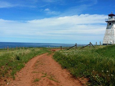
3. Taking Highway 1 east and south of Charlottetown brings us to Point Prim Road and Point Prim Lighthouse. Constructed in 1845 to guide mariners past the extensive reefs at the entrance to Charlottetown Harbour and Hillsborough Bay, it is the oldest lighthouse on P.E.I.


Question 4 of 10
4. Returning to the Trans-Canada Highway and following it south and east brings us to Wood Islands Harbour - the southernmost point of PEI. It is also the location of one of two ferry terminals on the island. Where does this ferry go?


Question 5 of 10
5. We leave Highway 1 and follow the coast along the eastern edge of the island as we continue north until reaching Basin Head Provincial Park, very close to the easternmost point of the island. Basin Head is known for its white-sand beaches that are geologically unique. By what nickname are they known? Hint


Question 6 of 10
6. Following the north shore westward along Highway 2 towards Charlottetown, we turn right at Hwy 6 and follow it to the Gulf Shore Parkway to reach yet another geological gem. Known for its red sand beaches and rocky red cliffs, Prince Edward Island National Park is the only national park on the island.


Question 7 of 10
7. Located within the bounds of P.E.I. National Park in Cavendish can be found the Green Gables Heritage Place, the original homestead of the Macneill family - cousins to which famous author of the "Anne of Green Gables" series of books? Hint


Question 8 of 10
8. Reconnecting with the Veteran's Memorial Highway (Hwy 2) and passing through the city of Summerside, we can follow it straight to P.E.I.'s northernmost point, or take the route that loops the entire northwestern portion of the island. What is this route called? Hint


Question 9 of 10
9. Continuing our journey down P.E.I.'s west coast we eventually reach the West Point Lighthouse, which was the first lighthouse constructed on the island by the federal government after Prince Edward Island joined Confederation. This happened in which year? Hint


Question 10 of 10
10. Our last stop, located along the southwest coast of the island, is a popular tourist destination. The 'Bottle Houses' were constructed in the 1980s - three buildings using about 25,000 glass bottles of varying colours. Which type of structure is NOT part of the 'village'? Hint


(Optional) Create a Free FunTrivia ID to save the points you are about to earn:

arrow Select a User ID:
arrow Choose a Password:
arrow Your Email:


View Image Attributions for This Quiz

Most Recent Scores
Today : elmslea: 10/10
Today : james1947: 10/10
Today : vlk56pa: 10/10
Today : spsullivan58: 2/10
Today : Iva9Brain: 8/10
Today : Guest 207: 6/10
Today : zartog: 4/10
Today : Guest 99: 3/10
Today : Rizeeve: 10/10

Quiz Answer Key and Fun Facts
1. After touring Nova Scotia, our next destination is Prince Edward Island, accessible by bridge since 1997. When the bridge was constructed, the federal government named it 'Confederation Bridge,' overruling the name suggested by the committee created for that purpose. What was the original name suggested for the Confederation Bridge?

Answer: Abegweit Crossing

The Confederation Bridge was built to fulfill a long-standing promise made when Prince Edward Island joined Canada in 1873: to maintain reliable year-round transportation to the mainland.

For decades, ferries provided this link, but winter ice often disrupted service. By the late 20th century, rising ferry costs and improved engineering made a fixed connection practical. After a 1988 plebiscite where Islanders voted in favour, construction began in 1993, taking nearly four years to complete and involving thousands of workers. The 12.9-kilometer structure, completed in 1997 at a cost of about $1.3 billion, became the longest bridge in the world over ice-covered waters.

Initially popularly known as the 'Fixed Link,' the naming process sparked debate. A committee recommended 'Abegweit Crossing' to honor Mi'kmaq heritage and the traditional name for the island, but the federal government chose 'Confederation Bridge' instead. This decision reflected a desire to emphasize national unity and PEI's role in the founding of Canada, particularly in the context of the recent-at-the-time Quebec referendum. While the name celebrates Confederation, ongoing discussions have considered alternatives that better recognize Indigenous history.
2. Having completed the crossing and reaching the island, it is a short eastward jaunt to P.E.I.'s capital city, Charlottetown, and Province House, the National Historic Site dubbed 'The Birthplace of Confederation.' Confederation wasn't on the agenda at that meeting in September, 1864. What had the delegates actually gathered together to discuss?

Answer: A maritime union

The Charlottetown Conference took place in September 1864 at Province House with delegates from Nova Scotia, New Brunswick, and Prince Edward Island. They had gathered to discuss the possibility of a maritime union, which would have created a single political entity from the three British colonies. However, representatives from the Province of Canada (modern-day Ontario and Quebec) joined the talks and proposed a much larger vision - a union of British North American colonies. This idea shifted the focus of the conference and ultimately laid the groundwork for Canadian Confederation in 1867.

Ironically, Prince Edward Island did not initially join Confederation, seeing little benefit in the prospect. The island had a strong economy, vibrant trade with the U.S. and other Atlantic colonies, and feared losing autonomy. Islanders worried about higher taxes, conscription, and having only a small voice in a distant federal parliament. But, by the 1870s the circumstances had changed, and the island colony found itself in a financial crisis. Facing mounting debt and limited options, P.E.I. negotiated with Ottawa for "better terms," and officially joined Confederation as the 7th province on July 1, 1873.
3. Taking Highway 1 east and south of Charlottetown brings us to Point Prim Road and Point Prim Lighthouse. Constructed in 1845 to guide mariners past the extensive reefs at the entrance to Charlottetown Harbour and Hillsborough Bay, it is the oldest lighthouse on P.E.I.

Answer: True

Point Prim Lighthouse, built in 1845, holds the distinction of being the oldest lighthouse on Prince Edward Island and one of only two round brick lighthouses in all of Canada. Before its establishment, shipwrecks were common along the Northumberland Strait, prompting merchants and shipowners to petition for a guiding light. After considerable debate over location, Point Prim was chosen for its strategic position at the southeastern entrance to Hillsborough Bay.

The design was created by Isaac Smith, the same architect behind Province House, and the tower originally stood as a bare brick structure before being clad in wooden shingles to protect it from harsh weather. Architecturally, Point Prim Lighthouse is notable for its tapered cylindrical shape and multi-sided cast iron lantern, a design rarely seen in Canada. It measures about 18 meters in height and has remained structurally sound for over 175 years, a testament to its craftsmanship.
4. Returning to the Trans-Canada Highway and following it south and east brings us to Wood Islands Harbour - the southernmost point of PEI. It is also the location of one of two ferry terminals on the island. Where does this ferry go?

Answer: Caribou, Nova Scotia

The Wood Islands ferry terminal was developed in the late 1930s to create a direct link between southeastern Prince Edward Island and Nova Scotia. Before any ferry service existed - prior to 1917 - Islanders depended on small mail boats and iceboats to cross the Northumberland Strait, a dangerous and unreliable journey, especially in winter.

The first formal ferry connection came in 1917 when the federal government introduced a route between Port Borden, PEI, and Cape Tormentine, New Brunswick, fulfilling its Confederation promise of year-round access. That service carried rail cars and later vehicles, and it remained the main link to the mainland for decades. The Wood Islands route began in 1941 as a seasonal alternative, offering a shorter crossing to Nova Scotia and boosting tourism and trade. Even after the Confederation Bridge opened in 1997, the ferry continued (and continues) to operate as a scenic and practical option for travelers.

The other ferry to the Magdalen Islands, that was mentioned in the question, departs from Souris, P.E.I., closer to the northeastern point of the island.
5. We leave Highway 1 and follow the coast along the eastern edge of the island as we continue north until reaching Basin Head Provincial Park, very close to the easternmost point of the island. Basin Head is known for its white-sand beaches that are geologically unique. By what nickname are they known?

Answer: The Singing Sands

Basin Head Provincial Park, located on the eastern tip of Prince Edward Island near the aforementioned Souris, is famous for its 'Singing Sands' beach. This nickname comes from a curious natural phenomenon: when you walk across the dry sand, it produces a squeaking or 'singing' sound. The effect is caused by the sand's unusually high silica and quartz content, which makes the grains smooth and spherical. When these grains rub together under pressure - such as footsteps - they create friction that produces the distinctive sound. Scientists have studied this phenomenon, but it remains relatively rare and is considered geologically unique to Basin Head.

The beach itself stretches for kilometers and is divided by a narrow channel called 'the run,' which connects to an inland tidal lagoon. This area is not only a popular swimming spot but also home to a marine protected zone that shelters a unique strain of Irish moss. Basin Head has evolved from a historic fishing hub into a major tourist destination, offering boardwalks, picnic areas, and the Basin Head Fisheries Museum. Its warm waters, striking white sand, and the novelty of the 'singing' effect have earned it recognition as one of Canada's top beaches.
6. Following the north shore westward along Highway 2 towards Charlottetown, we turn right at Hwy 6 and follow it to the Gulf Shore Parkway to reach yet another geological gem. Known for its red sand beaches and rocky red cliffs, Prince Edward Island National Park is the only national park on the island.

Answer: True

Prince Edward Island National Park was established in 1937 to protect the island's fragile north shore ecosystem and its cultural landmarks. Stretching for about 60 kilometers along the Gulf of St. Lawrence, the park encompasses sweeping beaches, red sandstone cliffs, and extensive dune systems that are home to rare plants and nesting sites for endangered species like the piping plover. Its creation reflected growing awareness of the need to preserve natural landscapes while also providing recreational opportunities for Canadians.

The park also holds deep cultural and historical significance. Archaeological evidence shows human presence in the area for over 10,000 years, beginning with Indigenous peoples who relied on the land and sea for survival. Later, French, Acadian, Scottish, Irish, and English settlers established fishing and farming communities along this coast.

In 1998, the park expanded to include the Greenwich Peninsula, known for its rare parabolic dunes and Mi'kmaq archaeological sites. Despite its beauty, the park faces challenges such as coastal erosion and human impact, making conservation efforts essential for its future.
7. Located within the bounds of P.E.I. National Park in Cavendish can be found the Green Gables Heritage Place, the original homestead of the Macneill family - cousins to which famous author of the "Anne of Green Gables" series of books?

Answer: Lucy Maud Montgomery

Green Gables House, located in Cavendish, Prince Edward Island, began as a modest farmhouse built by the Macneill family in the 1830s, with expansions through the 1870s. Lucy Maud Montgomery, who grew up nearby, often visited the property and later used it as the inspiration for the setting of her 1908 novel "Anne of Green Gables." The book's success made the house internationally famous as the fictional home of Anne Shirley and her adoptive family, Marilla and Matthew Cuthbert.

Interest in the site surged after the novel's publication and a 1934 film adaptation, prompting the Canadian government to purchase the property in 1936 as part of the development of Prince Edward Island National Park. Initially presented as a typical 19th-century farmhouse, the interior was later redesigned to match Montgomery's vivid descriptions in her novels. In 1985, Green Gables was officially recognized as a Federal Heritage Building, cementing its status as one of Canada's most celebrated literary landmarks.

Today, in addition to touring the house, visitors can explore trails like Lover's Lane and the Haunted Wood, and learn about Montgomery's life and writing through interpretive exhibits. The site includes a modern visitor center with a museum, gift shop, and café, and offers seasonal programming such as guided tours and costumed interpreters.
8. Reconnecting with the Veteran's Memorial Highway (Hwy 2) and passing through the city of Summerside, we can follow it straight to P.E.I.'s northernmost point, or take the route that loops the entire northwestern portion of the island. What is this route called?

Answer: North Cape Coastal Drive

The North Cape Coastal Drive is a 350-kilometer scenic route that loops around the northwestern tip of Prince Edward Island, starting and ending in Summerside. Known as "Canada's Oyster Coast," this drive showcases the island's rugged beauty and cultural heritage and is also famous for its Malpeque oysters and coastal dining experiences. Along the way, travelers encounter red sandstone cliffs, picturesque fishing villages, and attractions celebrating Acadian, Mi'kmaq, and Celtic traditions. Highlights include the Acadian Museum in Miscouche, the Canadian Potato Museum in O'Leary, and two other unique stops that will be visited in the final two questions of the quiz.

At the very tip of the island lies North Cape, where the Gulf of St. Lawrence meets the Northumberland Strait. This area is renowned for its dramatic red cliffs and the longest natural rock reef in North America, which becomes visible at low tide. North Cape is both a natural wonder and a hub for eco-tourism, where visitors can explore the Black Marsh Nature Trail, offering panoramic views of the coastline and opportunities to spot seabirds and marine life. The site also features the historic North Cape Lighthouse, an interpretive center focused on coastal ecology and renewable energy, and a wind energy research facility that underscores PEI's commitment to sustainability. combining breathtaking scenery with educational experiences.
9. Continuing our journey down P.E.I.'s west coast we eventually reach the West Point Lighthouse, which was the first lighthouse constructed on the island by the federal government after Prince Edward Island joined Confederation. This happened in which year?

Answer: 1873

West Point Lighthouse was constructed between 1875 and 1876, making it the first lighthouse built on P.E.I. after the province joined Confederation (in 1873). It was also the first lighthouse designed under the federal Department of Marine and Fisheries, marking a shift from the earlier round or octagonal masonry towers to a square, tapered wooden design. Standing at 20.6 m (about 68 ft) tall, it became the tallest lighthouse on the island and served as a critical navigational aid for vessels seeking shelter in the Northumberland Strait. It operated with just two keepers over its 88-year staffed history before being electrified in 1963 and automated soon after. In 1984, the West Point Development Corporation transformed the site into Canada's only inn inside a functioning lighthouse, while also adding a museum and visitor facilities.

Interestingly, despite its name, West Point is not the absolute westernmost point of Prince Edward Island. That distinction belongs to West Cape, located several kilometers to the north and slightly west of West Point. While West Point is famous for its lighthouse and Cedar Dunes Provincial Park, West Cape is notable for its wind farm and rugged coastline.
10. Our last stop, located along the southwest coast of the island, is a popular tourist destination. The 'Bottle Houses' were constructed in the 1980s - three buildings using about 25,000 glass bottles of varying colours. Which type of structure is NOT part of the 'village'?

Answer: The Barn

The Bottle Houses at Cap-Egmont are among Prince Edward Island's most whimsical attractions, created by Édouard Arsenault in the early 1980s. The idea began in 1979 when his daughter sent him a postcard showing a glass bottle structure in British Columbia.

Inspired by the image, Arsenault decided to build something similar on P.E.I. Over four years, he collected more than 25,000 bottles from neighbors, restaurants, and community events, embedding them in cement to construct three buildings: a six-gabled house, a tavern, and a chapel.

The translucent walls sparkle in sunlight, creating a colourful, almost magical effect. The site also includes gardens, walking paths, and a small museum that tells the story of Arsenault's vision.
Source: Author reedy

This quiz was reviewed by FunTrivia editor agony before going online.
Any errors found in FunTrivia content are routinely corrected through our feedback system.
11/20/2025, Copyright 2025 FunTrivia, Inc. - Report an Error / Contact Us