FREE! Click here to Join FunTrivia. Thousands of games, quizzes, and lots more!
Quiz about Were on a Road to Nowhere

We're on a Road to Nowhere Trivia Quiz

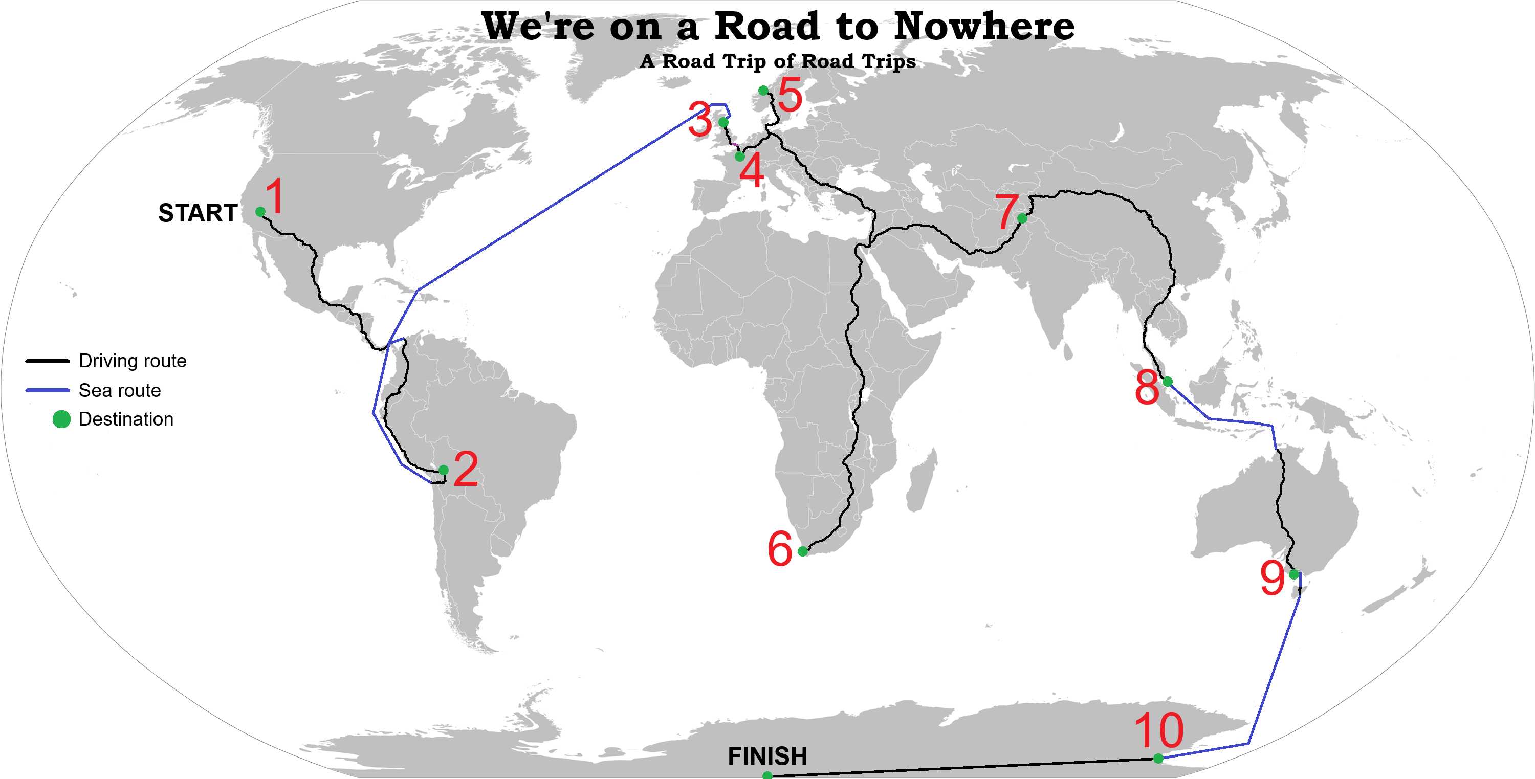
A Road Trip of Road Trips

Let's go for a road trip on some of the most iconic roads and highways across the seven continents, all the way to the South Pole!

A label quiz by patrickk. Estimated time: 3 mins.
  1. Home
  2. »
  3. Quizzes
  4. »
  5. World Trivia
  6. »
  7. Transport
  8. »
  9. Roads & Highways

Author
patrickk
Time
3 mins
Type
Label Quiz
Quiz #
424,801
Updated
Jul 26 26
# Qns
10
Difficulty
Very Easy
Avg Score
9 / 10
Plays
32
Last 3 plays: cardsfan_027 (10/10), Changeling_de (10/10), kstyle53 (10/10).
Match the iconic road or highway to its location on the world map, as labelled by the numbers 1 to 10. The navigation routes can be ignored for the purposes of the quiz, but will be explained further in the interesting information sections.
Click on image to zoom
McMurdo Highway Great Ocean Road The Royal Mile Karakoram Highway Atlanterhavsveien Champs-Élysées Yungas Road (Death Road) Fremont Street Chapman's Peak Drive Orchard Road
* Drag / drop or click on the choices above to move them to the answer list.
View Image Attributions for This Quiz
1.   
2.   
3.   
4.   
5.   
6.   
7.   
8.   
9.   
10.   

Most Recent Scores
Today : cardsfan_027: 10/10
Today : Changeling_de: 10/10
Today : kstyle53: 10/10
Today : Kabdanis: 8/10
Today : Guest 208: 7/10
Today : DeepHistory: 10/10
Today : awr1051: 10/10
Today : bopeep: 10/10
Today : chrisatlas: 5/10

Quiz Answer Key and Fun Facts
1. Fremont Street

We begin our journey in the Silver State of the United States of America, sunny Nevada. In the southeast corner of the state, a short distance from Hoover Dam and Lake Mead, lies the Las Vegas Valley, home to three quarters of Nevada's population.

When you think of Las Vegas, you probably imagine the Strip, a long boulevard with all of the most iconic casinos in town - the Bellagio, Luxor, Caesars Palace, the Venetian et al. However, the Strip actually lies not within the city limits of Las Vegas, but in the adjacent unincorporated towns of Winchester and Paradise. This means that Fremont Street in Downtown Las Vegas is actually the most famous street within the Las Vegas city limits. Though not quite as universally recognised as the Strip, Fremont Street attracts its fair share of casinos and visitors.

Fremont Street dates back to the founding of Las Vegas in 1905. It became the city's first paved street in 1925, and saw the city's first traffic light in 1931. Its boom came thanks to construction of the Hoover Dam from 1931 to 1935. Male workers flooded in from across the country to build the dam, and local business owners and Mafia crime lords were quick to sense the opportunity. They built casinos and showgirl theatres, and alcohol found its way into the mix despite Prohibition still being in place. The state of Nevada also saw the opportunity to further encourage local business development by legalising gambling in 1931.

After the dam was completed and the worker population had moved away, Las Vegas was able to retain its relevance as a gambling hotspot, and as a hub for upscale hotels servicing tourists to Hoover Dam and Lake Mead. Abundant hydroelectricity from the dam powered the shimmering neon lights of Fremont Street, which had now become known colloquially as Glitter Gulch. Over the next few decades, Las Vegas was able to consolidate its early advantages to become the gambling and entertainment mecca we know it as today.

Today, Fremont Street has remained the hub of Downtown Las Vegas. The most heavily developed western part of the street, including Glitter Gulch, was pedestrianised in 1995. Branded as the Fremont Street Experience, the main attraction is a barrel vault LED canopy 419 metres (1,375 feet) in length that displays impressive visuals overhead. Coupled with music blaring from speakers or one of the three stages hosting free concerts, street performers, and the bright lights of the casinos and venues along its length, it is a unique sensory experience for pedestrians that truly rivals the experience of driving down the Strip.
2. Yungas Road (Death Road)

It's more than 10,000 km (6,200 miles) drive to our next destination now, down the Pan-American highway (I hope you brought some snacks). This is a vast network of roads stretching a colossal 30,000 km (19,000 miles) from Prudhoe Bay, Alaska, United States, in the north, to Ushuaia, Argentina, in the south. Well, it would be were it not for the famed Darién gap between Panama and Colombia. There is no road across this narrow isthmus, leaving North and South America without a road link. There are numerous reasons for this puzzling absence, but this is a quiz about roads and highways, not voids where there should be a road, so I digress.

Instead, we will first have to drive to Colón on Panama's Caribbean coast, a distance of 6,348 km (3,945 miles). This port lies next to the northern end of the Panama Canal. From here, we can put the car on a cargo ship and resume our journey from Cartagena, Colombia. We still have another 5,205 km (3,234 miles) ahead of us before we reach La Paz. This is the de facto capital of Bolivia, and home to its administrative centre. Located at 3,650 metres (11,975 feet) above sea level, it lies within a bowl-like depression, overlooked by the adjacent city of El Alto on the plains above. A cable car / gondola system consisting of 10 lines, the largest such system in the world, ferries over 100,000 people daily between and around the cities, with exceptional views along the way.

Yungas Road is a 64 km (40 mile) road connecting La Paz to the Yungas region in the north, a gateway to the Amazon jungle. It was built in the 1930s by Paraguayan prisoners taken during the Chaco War between Bolivia and Paraguay. The original road was unsealed, narrow (as little as 3 metres / 9.8 feet in places), and built on the treacherous slopes of the imposing Bolivian Andes, with no guard rails. Further hazards included limited visibility from frequent rain and fog, landslides, cascades passing over the road surface, and a steep incline along much of its length.

To mitigate the risks, the road was made left-hand traffic, as opposed to right-hand traffic that was standard in Bolivia. This allowed downhill drivers to better judge where their outside wheels were when passing vehicles, so as not to slip off the edge and into the valley below. Despite the dangers, as a crucial arterial road, Yungas Road saw large volumes of traffic, and it claimed some 100-300 lives a year. It was widely considered to be the world's most dangerous road, attracting the moniker of Camino de la Muerte, or Death Road.

An upgrade to the route was completed in 2006 after 20 years of construction, paving the road, widening it to two lanes, installing guardrails and drainage, and completely bypassing 30 km (18.6 miles) of the most treacherous section. It is now a rather unremarkable mountain highway, much to the relief of those who depend on it.

For the thrill seekers out there, an adventure tourism industry has emerged on the bypassed section of the old route, which sees dozens of tourists negotiate the road on mountain bikes each day. I was fortunate enough to cycle down this road in 2023 (or should I say unfortunate, brave, or just silly?). Starting at 4,600 metres elevation (15,000 feet) at La Cumbre pass, we coasted downhill for a 20 km (12.4 mile) stretch of the new paved highway before turning off onto the old unpaved route. We followed it all 30 km (18.6 miles) down into the valley, for a total descent of 3,500 metres (11,500 feet). Incredibly, over that whole ride, we only ascended for a total of 6 metres (20 feet).

Stripped of most of its former traffic, the road feels wide and rather safe for cycling, especially compared to other mountain bike routes with single track width. There is still some inherent risk, of course - numerous cyclists have gone over the edge and perished after brake or mechanical failures, or losing control while going too fast. Yet for those with confident cycling skills, using a trusted tour operator with appropriate bicycle maintenance, it is a fantastic day out.
3. The Royal Mile

We have a small issue now with our next destination. Separated from the British Isles by the Atlantic Ocean, we'll need to hit the seas again. Complicating matters is the fact that Bolivia lost its access to the Pacific coastline to Chile in the War of the Pacific in the 19th century. Thus we'll have to drive into Chile, to the Port of Arica, 564 km (350 miles) away. We'll arrange another cargo ship to take our car to Edinburgh, through the Panama Canal we drove past a few weeks ago. This journey will itself take a few weeks, so we'll fly from Arica to Edinburgh via Santiago and London. We can explore the city while we wait for our car to arrive. Luckily, the next road on our list is best enjoyed on foot anyway.

Edinburgh lies in the north of Great Britain. It is the capital and second-most populous city of Scotland. It is located on the southern shore of the Firth of Forth, an inlet of the North Sea on Scotland's east coast. It is built around seven hills formed from volcanic remnants, analogous to the seven hills of Rome.

The Royal Mile forms the backbone of Edinburgh Old Town. Running west to east for close to one mile (depending on where you take the start and end to be) between Edinburgh Castle and Holyrood Palace, it is the busiest tourist street in Edinburgh, featuring an abundance of shops, restaurants and visitor attractions. It is comprised of numerous streets laid out in series - from west to east: Castlehill, Lawnmarket, High Street, Canongate, and Abbey Strand.

Edinburgh Castle sits upon Castle Rock, a volcanic plug comprised of basalt. During a previous glaciation event, ice sheets passing over the area scoured and eroded away the softer surrounding ground, leaving behind the prominent basalt crag we see today. The crag protected the land directly behind it from erosion, leading to the formation of a tail that gradually slopes down towards the location of Holyrood Palace. It is along this tail that the Royal Mile sits.

There are perhaps too many attractions along the Royal Mile to do them all justice in this section, but I will highlight St Giles' Cathedral. While the hundreds of churches and cathedrals across Europe can certainly blur together after a while, St Giles' stands out to me with its varied architectural styles and colourful decorative banners. It is also well worth the short hike from the eastern terminus of the Royal Mile to Arthur's Seat, another volcanic crag with exceptional views over the Royal Mile, Edinburgh, and the Firth of Forth.
4. Champs-Élysées

Next we go to Paris, City of Light and capital of France. I would love to save us some driving by availing ourselves of the Motorail train service that carried passengers and cars across Great Britain between 1955 and 1995. Alas, it is now defunct due to improvements in the motorway network and car comfort making long-distance driving far easier and cheaper than loading one's car onto a train.

We won't pass up the opportunity to take the last remaining car-carrying train service in Britain, however. The Channel Tunnel hosts LeShuttle, a train service which takes cars and passengers under the English Channel from Folkestone, England, to Calais, France. It's either that or the car ferry from Dover to Calais, anyway. In total, it's just over 1,000 km (621 miles) of driving from Edinburgh to Paris.

We arrive at one of the most iconic roads in the world, l'avenue des Champs-Élysées, usually shortened to the Champs-Élysées. The name is French for "the avenue of Elysian Fields", in reference to the afterlife realm for heroes in Greek mythology. It runs for 1.9 km (1.2 miles) from Place de la Concorde to the Arc de Triomphe, where it meets a twelve-way roundabout. It is a broad road, with three to four lanes of traffic in each direction, separated from wide pedestrian strips by lines of trees on either side.

The Champs-Élysées gradually developed from the 17th century onwards. By the 19th century, it had attracted a reputation as a fashionable avenue. Today, the Champs-Elysées is home to numerous theatres, cafes and luxury shops. It is an iconic travel destination, allowing tourists to absorb the Parisian atmosphere as they traverse its short length.

The Champs-Élysées is largely avoided by locals, due to its abundance of tourism-focused infrastructure and businesses. However, it remains an icon of Paris and France, and plays host to major events such as the annual Bastille Day military parade, and the finish line of the final stage of the Tour de France.
5. Atlanterhavsveien

Not much of a road trip so far, you say? I get it, we have done an awful amount of flying, seafaring, and a little travel by rail so far. Well, I have good news - our next four destinations will be fully accessible by road, and we will avail ourselves of the opportunity to get the road trip started in earnest. Strap yourself in, it's going to be a reeeeally long one!

Our first journey is mercifully short, only 2,558 km (1,589 miles). Alright, sure, that's actually pretty long. But we're achieving it without any ferry crossings, and thanks to a road link across the Øresund Strait between Denmark and Sweden, we are avoiding a detour through St Petersburg in Russia which would more than double the length of the journey. This road link deserves a special mention. A 7.85 km (4.88 mile) bridge links Malmö in Sweden to an island in the Øresund Strait, from where a tunnel burrows under the rest of the strait to reach Copenhagen in Denmark. When driving southbound, this gives the stunning illusion of the water swallowing up the highway as the road descends from the bridge to the island, and into the tunnel.

But our tour of Scandinavian engineering prowess is only just beginning. When we arrive at our destination, we are greeted with a series of causeways, viaducts and bridges that connect a string of small islands and skerries. These form the 8.3 km (5.2 miles) long Atlanterhavsveien, or Atlantic Ocean Road, connecting the island of Averøy to the Norwegian mainland.

The engineering highlight of the route is the cantilever Storseisundet Bridge, elegantly curving to a height of 23 metres (75 feet) above a small channel, with further curves in the approaching roadways making it very aesthetically pleasing. But the real attraction of the road is how it complements the natural beauty of the ocean, rocky islands, and mountainous background, seamlessly snaking through as if it's part of the natural environment. It is a popular tourist attraction, and has been labelled one of the best road trips in the world by British newspaper "The Guardian".

Construction took place from 1983 to 1989. The cost of building the road was recuperated through a toll, which was removed in 1999 when the construction bill was paid off. This is a lesson that places like Sydney, Australia could learn from. Highways constructed and paid-for decades ago here have had their tolls reinstated to help fund new roads (which have their own tolls already), all to indefinitely fill the pockets of private companies, with no plans for expiration of the tolls.
6. Chapman's Peak Drive

From the northerly reaches of Norway, our journey now takes us down a whopping 15,965 km (9,920 miles) of roads to the southern tip of Africa. This is longer than the diameter of the Earth, and will take us a couple of weeks. Yet by the grace of Afro-Eurasia being a single land mass, only disrupted by the narrow man-made Suez Canal (spanned by multiple bridges of course), we can drive the entire route, again without requiring a ferry. We'll have to cross through 21 countries, negotiate left- and right-hand traffic, service the car along the way, sort out a few visas and insurance, and contend with tropical infectious diseases, but it's fortunate we have sufficient determination (and that we're doing the trip virtually through a trivia website).

At long last we arrive at Cape Town, South Africa. Located almost as far south as you can go on the African continent, Cape Town is set in a stunning location along the coast with a mountainous backdrop. The Cape Peninsula, home to Table Mountain and the Cape of Good Hope, extends southward for 52 km (32 miles). It is here that we find Chapman's Peak Drive hugging the rugged western coast of the peninsula.

Chapman's Peak Drive was only the second road to be built to the southern suburbs of Cape Town, after De Waal Drive was built on the east coast. Faced with a choice of going over an inland mountain pass or a spectacular route along the vertical sea cliffs, town administrators made the bold choice to go with the latter. Construction took seven years, with the road opening in 1922.

The road has been beset by numerous closures through its history, and there have been a few deaths due to rockfalls and landslides. The route has been progressively upgraded with bridges and tunnels to bypass dangerous sections, and there have been significant works to remove or stabilise loose overhead rocks and install fences to shield the road from rockfall. With modern monitoring systems in place, the road is safer than it has ever been, though some unfortunate souls have still perished in recent times after plummeting off the edge.

I hope you have enough stamina to travel the 9 km (5.6 miles) and 114 curves of this gorgeous road before we embark on our next long-haul adventure. Oh, and could you spare a few South African Rand for the toll? I only have these Norwegian Kroner in my pocket.
7. Karakoram Highway

It doesn't get any easier from here. We now face another journey of over 15,000 km (9,320 miles), doubling back across the length of Africa, then through the Middle East, through 14 countries, to Islamabad, capital of Pakistan.

From here, our route takes us on the Karakoram Highway, which runs for around 1,300 km (810 miles). Starting near Islamabad, it follows river valleys through the Karakoram mountain range, including upstream reaches of the famed Indus River. It then rises to an elevation of 4,714 metres (15,466 feet) to reach the Khunjerab Pass on the border between Pakistan and China. From here it continues as the China National Highway 314, terminating at Kashgar in the Xinjiang Uyghur Autonomous Region. Construction took place from 1962 to 1979, but the highway was not opened to the public until 1986. It is one of only a handful of sealed roads that crosses the major mountain ranges of Asia (Himalayas, Karakoram and Hindu Kush).

The highway passes through a desolate and somewhat unstable region of the world. Because of its proximity to Afghanistan, Tajikistan and the disputed regions of Ladakh, Jammu and Kashmir, it was built in partnership between Pakistan and China to facilitate mobility in the region for military, security and economic reasons. It is the only formal road connection between China and Pakistan, and is sometimes referred to as the China-Pakistan Friendship Highway.

The Karakoram Highway passes through some of the most jaw-dropping scenery on Earth. Starting from a humid subtropical climate of the foothills at the southern end, it passes through forests, alongside broad thundering mountain rivers, amongst some of the highest snow-capped mountains in the world, and into the high-altitude desert plains beyond. It is nestled amongst mountains of all shapes, with rocks of various colours. The highway passes just 25 km (15.5 miles) away from Nanga Parbat, the ninth tallest mountain in the world at 8,126 metres (26,660 feet) above sea level.

The cultural history of the region is equally impressive. Various ethnic groups developed distinct cultures in such a small region due to the isolation imposed by geographical barriers and climate variation. Amongst others, the route is home to Punjabis in central Pakistan, Ismailis in Hunza, Tajiks in Tashgurkan, and Uyghurs in Xinjiang. Yet historically, there has still been a significant diffusion of people, goods, and culture, due to trade routes along the highway's alignment. These linked the interior of China to the Indian subcontinent as part of the historic Silk Road trade network. There are over 50,000 pieces of rock art and petroglyphs along the route, left behind by locals, traders, pilgrims, and invaders of millennia gone by.

All this makes the Karakoram Highway an increasingly popular destination for adventure tourists, particularly for cyclists, who can really take in the diversity of landscapes and culture with their slower pace of travel. Were it not for the unstable security situation in Pakistan, and significant travel restrictions in the politically sensitive Xinjiang region of China, I have no doubt this would be one of the most popular road trips in the world.
8. Orchard Road

At last, our next destination requires no doubling back. We can continue through China, a few countries in mainland Southeast Asia (reasonably direct routes could potentially take us through all of these countries except Cambodia), and arrive in Singapore after a distance of some 8,500 km (5281 miles). Thanks to the 1 km (0.66 mile) Johor-Singapore Causeway across the Straits of Johor between the mainland of Malaysia and the island of Singapore, we again need not leave the open roads along the way.

We don't have to go far once we hit Singapore, which is only 27 km (17 miles) from north to south. Orchard Road traverses 2.5 km (1.6 miles) through the central region of Singapore. It dates back at least as far as the 1830s during the British colonial era of Singapore. It can be seen on the 1836 map of Singapore as an unnamed road trundling off the edge of the map, through gambier (a traditional Chinese medicine plant) and pepper plantations. Its modern name came from the nutmeg and fruit plantations that came to follow.

Being such an early arterial road, Orchard Road has evolved drastically over the centuries. It has been home to plantations, houses, bungalows, mansions, graveyards, and embassies. Today, it is dominated by upscale shopping malls, bright colourful lights, and amenities to cater to tourists such as restaurants and cafes. Its eastern end is home to the Istana, a sprawling complex of gardens, offices, and living quarters for Singapore's president and prime minister.

The real highlight for me is the amazing variety of Singaporean cuisine at the local eateries. With Chinese, Malay, Indian and European influences, there is something for everyone here. All at a very reasonable price too! I'd make sure to fill up before the next leg of our journey.
9. Great Ocean Road

Unfortunately we've hit the end of the road here, the southernmost part of continental Southeast Asia. From here, there is no road or even car ferry to get us to the Australian continent. We could attempt to traverse the islands of Indonesia and East Timor to minimise our time on the seas, but this would require at minimum half a dozen short water crossings before a 600 km (373 mile) stretch to reach Darwin in Australia's north. We'd need to arrange each of these crossings individually with cargo transportation for the car, and we'd then have to fly or travel separately to meet the car on the other side.

So we'll just bite the bullet and do it all in one go, loading the car onto a cargo ship and taking the five hour flight from Singapore to meet it in Darwin 1-2 weeks later. At least we've got an easy road ahead now, sealed all the way to our next destination. 3,641 km (2,262 miles), along the Stuart Highway through the barren interior of Australia, passing by Adelaide on the Gulf of St Vincent, and on to Allansford in southern Victoria.

Here we pick up the Great Ocean Road, an iconic 240 km (150 mile) stretch of road from Allansford to Torquay. Just over an hour's drive away from the major city of Melbourne, it is one of the premier tourist attractions of regional Victoria. The road hugs the spectacular coastline of southern Victoria, past beaches, cliffs, and rock formations including London Bridge and the Twelve Apostles, running through koala-rich rainforest, and through rural farmlands.

The road was planned towards the end of World War I as an employment project for returned soldiers. It was built by 3,000 workers from 1919 to 1932, opening in stages. It connected a series of isolated settlements previously only accessible by sea or bush track. The original road was only wide enough for one vehicle in many places, with sheer cliffs and few passing opportunities. Gradual improvements have led to the modern two-lane road motorists enjoy today.

We must remember to keep left, by the way. Being a major attraction for overseas drivers, it is not uncommon for drivers to end up driving on the wrong side in times of low traffic, particularly after stopping at one of the many scenic vistas. There are numerous signs reminding drivers to "drive on left in Australia", just in case we forget!
10. McMurdo Highway

Our next drive is mercifully brief - just 27 km (16.8 miles) to Geelong, where we can board the Spirit of Tasmania car ferry. Alighting in Devonport on Tasmania's northern coastline, we face our final drive of this journey, 280 km (174 miles) to Hobart, capital of Tasmania. Here we will board a research vessel bound for Antarctica. The United States Antarctic Program has given us special permission to visit the McMurdo station, and they will kindly transfer us to the South Pole via the McMurdo Highway on one of their supply runs.

It's time to say goodbye to our car, at long last. We won't be taking it, as it would require extensive modifications to handle the ice roads and conditions of Antarctica. Don't forget to take your luggage (and snacks) with you, as it won't be easy to source replacements at our next destination!

McMurdo Station lies on Ross Island, a small but highly mountainous island just off the Antarctic continent. While geologically an island, it is connected to the mainland via a permanent glacial ice sheet on its south and eastern side. McMurdo Station is built on the southern tip of the island, and is accessible by sea via the McMurdo Sound. It is home to the southernmost port on Earth. Supporting anywhere from 150 to over 1,000 people depending on the season, McMurdo Station is the largest science and research base in Antarctica.

Further inland, at the South Pole, lies the Amundsen-Scott South Pole Station. In order to facilitate the transport of people and cargo to the South Pole, the McMurdo Highway was constructed over the ice and snow to connect it to the coast and McMurdo Station. It was constructed between 2002 and 2005 by filling in crevasses and levelling snow to create a flat road surface. There is of course no gravel or pavement, only the endemic ice and snow. The road has attracted several other names through its history, including the South Pole Traverse, South Pole Overland Traverse (SPoT), and McMurdo-South Pole Highway. It is considered the southernmost road in the world, with no other major roads existing in the southern continent.

The McMurdo Highway runs for about 1,601 km (995 miles). From McMurdo Station, the majority of its route is a near-straight shot across the Ross Ice Shelf. This behemoth of floating ice is about the size of France in area, with ice up to 750 metres (2,460 feet) thick, though only 15-50 metres (50-160 feet) lies above sea level. Upon reaching the mainland, the route gradually ascends up to the Antarctic Plateau at over 3,000 metres (10,000 feet) elevation, via the Leverett Glacier. Cutting through the Transantarctic Mountains, this is the shortest, but also the most unstable section of the route. It sees significant crevasse formation due to the rapid flow of the ice sheets, and thus requires crevasse monitoring and maintenance work each season. Once on the relatively stable Antarctic plateau, the route turns to face directly south, making a beeline straight for the South Pole.

Transport along the highway is largely undertaken by convoys of tracked haulers and sleds. While the round trip journey can take weeks to months, it allows large volumes and masses of cargo to be delivered to the South Pole, compared to the limited cargo services offered by air transport. Adventurous individuals also take advantage of the highway to the interior, and it has been used on expeditions to ski or even cycle from the Antarctic coast to the South Pole.

The end of the road is the furthest south one can go on Earth - the Geographic South Pole, 90 degrees South. This is the point where the Earth's axis of rotation intersects with the surface. The ice sheet here is almost 3 km (1.9 miles) thick, yet it moves a few metres every year as it slowly flows into the Weddell Sea. Structures also get slowly buried by the accumulation of snow, which is unable to melt in the extreme cold. Though these factors may not seem like much, in just 100 years, Roald Amundsen's tent at the South Pole has drifted around 2 km (1.2 miles) away and become buried around 17 metres (56 feet) below the surface. Thus the marker of the Geographic South Pole is repositioned each year on New Year's Day to keep it calibrated. There is also a Ceremonial South Pole near the Amundsen-Scott South Pole Station, with a kitsch barber pole designed for photo opportunities.
Source: Author patrickk

This quiz was reviewed by FunTrivia editor stedman before going online.
Any errors found in FunTrivia content are routinely corrected through our feedback system.
7/26/2026, Copyright 2026 FunTrivia, Inc. - Report an Error / Contact Us