FREE! Click here to Join FunTrivia. Thousands of games, quizzes, and lots more!
Quiz about Our Earth From Space

Our Earth From Space Trivia Quiz


Welcome to my quiz on our world as seen from space.

A photo quiz by mcsurfie. Estimated time: 2 mins.
  1. Home
  2. »
  3. Quizzes
  4. »
  5. For Children Trivia
  6. »
  7. Our World for Kids
  8. »
  9. Mixed World Geography for Kids

Author
mcsurfie
Time
2 mins
Type
Photo Quiz
Quiz #
377,981
Updated
Dec 03 21
# Qns
10
Difficulty
Easy
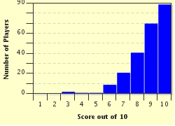
Avg Score
9 / 10
Plays
1053
Last 3 plays: Richard27 (10/10), Guest 24 (8/10), Guest 173 (4/10).
-
Question 1 of 10
1. Situated between Asia and Europe, which of the following bodies of water is the world's largest inland sea? Hint


Question 2 of 10
2. One of North America's greatest wonders, which of the following rivers helped form the Grand Canyon? Hint


Question 3 of 10
3. Which of the following of the Great Lakes is found completely within the United States? Hint


Question 4 of 10
4. On which continent is the Okavango River Delta found? Hint


Question 5 of 10
5. Is the Great Barrier Reef located off the east coast of Australia made up mainly of coral?


Question 6 of 10
6. Volcanoes are found around the world, but which of the following volcanoes destroyed the Roman city of Pompeii in 79 A.D.? Hint


Question 7 of 10
7. This satellite image is of which of the following oceans found on Earth? Hint


Question 8 of 10
8. Is the Thames Estuary part of the River Thames, located in England?


Question 9 of 10
9. Uluru (or Ayers Rock) is found on which of the following continents? Hint


Question 10 of 10
10. Which of the following mountain ranges CANNOT be found in this satellite image of the western half of the United States of America? Hint


Most Recent Scores
Mar 31 2024 : Richard27: 10/10
Mar 30 2024 : Guest 24: 8/10
Mar 20 2024 : Guest 173: 4/10
Mar 05 2024 : Guest 38: 10/10
Feb 27 2024 : kitter96: 9/10

Score Distribution

quiz
Quiz Answer Key and Fun Facts
1. Situated between Asia and Europe, which of the following bodies of water is the world's largest inland sea?

Answer: Caspian Sea

Bordered by Russia, Iran, Kazakhstan, Turkmenistan and Azerbaijan, the Caspian Sea is the world's largest landlocked body of water on Earth. Covering an area of approximately 371,000 sq km (143,200 sq miles), the northern part of the Caspian Sea is also one of the lowest points on Earth.

Since the Caspian Sea is located in a depression in the Earth's surface, there are no rivers flowing out of the sea. However, unlike Lake Superior in North American, the Caspian Sea is no longer a freshwater lake, but has a slight salinity around one third of that of the world's oceans.

The smaller body of water on the right of the Caspian Sea is the Garabogazköl Aylagy, a lagoon that is fed by the Caspian Sea by a small channel.
2. One of North America's greatest wonders, which of the following rivers helped form the Grand Canyon?

Answer: Colorado River

Situated in Arizona, the Grand Canyon was formed partially by the uplift of the Colorado Plateau, and erosion caused by rain that fell on the Colorado River drainage area.

The walls of the canyon are made up of a number of different types of rock including limestone, sandstone and granite that were initially laid down during the formation of the Earth's surface. As the Colorado River and weathering cut through the layers of rock, it exposed them and created cliffs that include a number of layers of different coloured rock. This has resulted in the Grand Canyon becoming one of the United States of America's best known natural landmarks.
3. Which of the following of the Great Lakes is found completely within the United States?

Answer: Lake Michigan

Unlike lakes Superior, Huron, Ontario and Erie, Lake Michigan is the only one of the Great Lakes that is located completely in the United States of America. Whilst Lake Superior is the largest freshwater lake in the world by surface area, Lake Michigan is the largest lake by surface area located solely within one country.

The name of Lake Michigan comes from the indigenous North American Indian tribe of the Ojibwe word mishigami or "great water". Earlier maps show Lake Michigan listed though as Lake Illinois.

Like the other "great lakes", Lake Michigan was formed during a period of great glacial activity around 14,000 years ago. As the Earth's surface began to warm up, the glaciers retreated northwards, the melting ice collecting in depressions, thus creating the lakes.
4. On which continent is the Okavango River Delta found?

Answer: Africa

Located in Botswana in the southern half of Africa, the Okavango River delta is unusual in that rather flowing into a sea or ocean, it flows into a desert. As a result, the water that flows through the delta has created a swamp, bring life to parts of the Kalahari Desert.

Although the Okavango River brings a large quantity of water into the delta, some of the water is also brought via heavy rainstorms that occur between December and March. Much of this water is consumed by plant life, or lost via evaporation. Only a small percentage finds its way into aquifers and Lake Ngami - which is located in the southern half of the delta.

The delta itself is formed where the Okavango river flows into a depression that was once an ancient lake. Since there is nowhere for the salts and minerals that accumulate in the delta to be flushed away, they eventually create salt islands that are largely barren.
5. Is the Great Barrier Reef located off the east coast of Australia made up mainly of coral?

Answer: Yes

Situated off the eastern coast of Australia, the Great Barrier Reef is one of the world's biggest living natural wonders. Comprised of nearly 3,000 separate reefs, and almost 1,000 islands, the Great Barrier Reef runs for nearly 2,300km (1,400 mi), covering an area that is roughly 344,400 square kilometres (133,000 sq mi)

Much of the reef is built by coral - small marine invertebrates - which secrete calcium carbonate to form shells over varying shapes and colours. As coral dies, it then fragments, allowing sand and rocks to accumulate. As sea levels rise and fall, these then can eventually create small islands. As such, the reef is host to a wide range of aquatic biodiversity.

Listed as one of the world's natural wonders, the Great Barrier Reef is at risk, not only from pollution, sediment and shipping, but the Crown-of-Thorns starfish which preys on the coral.
6. Volcanoes are found around the world, but which of the following volcanoes destroyed the Roman city of Pompeii in 79 A.D.?

Answer: Mount Vesuvius

Overlooking the Bay of Naples in Italy, Mount Vesuvius is considered the only active volcano that can be found on the European mainland. Vesuvius - along with other volcanoes that can be found in islands located off the Italian coast - were formed where the African tectonic plate ran under the Eurasian tectonic plate.

Vesuvius is most famous for the eruption that occurred in 79 A.D., which resulted in the cities of Pompeii and Herculaneum becoming buried in volcanic ash and rock that erupted from Vesuvius in a pyroclastic flow. It was not until the late 16th century that the site of Pompeii was rediscovered, with a more thorough excavation being made in the mid 18th century.

As the city of Naples has expanded, it too is under threat from further eruptions from Mount Vesuvius, along with the possibility that there maybe one day eruptions from the nearby Phlegraean Fields (Campi Flegrei) which is situated in the bay of Naples.

During the 20th century, there were two major eruptions of Vesuvius. One which occurred in 1906, which led to the Olympic games that was scheduled to be held in Italy being moved to London, England. The other took place in 1944, resulting in damage to a number of settlements, along with damage to aircraft of the USAAF 340th Bombardment Group - which were stationed in Europe during World War II.
7. This satellite image is of which of the following oceans found on Earth?

Answer: Pacific Ocean

The largest ocean on Earth, the Pacific Ocean is bound by the Americas to the east, and Asia / Australasia to the west, whilst to the north and south are the Arctic and Southern Oceans. Due to the large amount of volcanic activity in those countries who shores are on the Pacific rim, this area is dubbed the "Ring of Fire".

Since the Equator runs through the Pacific Ocean, it is split up into two areas, one north, the other south. In addition, the Pacific Ocean is the world's deepest ocean at a point known as the Mariana Trench that is located east of the Mariana Islands. Here the Pacific Ocean is 10,994 m deep, with the deepest point being known as the Challenger Deep.
8. Is the Thames Estuary part of the River Thames, located in England?

Answer: Yes

England's longest river, the River Thames, rises at Thames Head in Gloucester, flowing through the southern half of England until it flows into the Thames Estuary, emptying out into the North Sea.

Although the shorelines of the Thames Estuary are still shifting in part due to coastal erosion, the shape of the estuary as it can be viewed now developed during the Ice Age around 20,000 BC. As the ice melted, the course of the River Thames changed, as sea levels began to increase, the Thames Estuary was formed.

The location of the Thames Estuary once made it an important route for maritime trade, with large amounts of goods brought into England's capital of London. Although the Port of London went into decline during the latter half of the 20th century, ports still exist in Gravesend, Tilbury, and near the Dartford Crossing, which are a combination of two tunnels and a bridge that allow vehicles to cross the River Thames.

Fishing is another vital part of the economy for ports that lie upon the Thames Estuary, with one of the more famous being Whitstable in Kent, renowned for its annual oyster festival. In addition, the Thames Estuary is home to the London Array, a large off shore wind farm which generates electricity. The location of the London Array is hilighted by the rectangle seen in the image.
9. Uluru (or Ayers Rock) is found on which of the following continents?

Answer: Australia

Situated in central Australia - in the southern half of the Northern Territory - Uluru (Ayers Rock), is a great sandstone inselberg rising out of the Simpson Desert. Reaching a height of 348 m (1,142 ft), Uluru covers an area of 3.3 sq km. From the top of Uluru, another rock formation known as Kata Tjuṯa (The Olgas) can be seen. Together, Uluru and Kata Tjuṯa form part of a national park known as the Uluṟu-Kata Tjuṯa National Park. Despite sandstone normally being grey in colour, the large amount of iron oxide found in the sandstone gives Uluru its reddish colour, a colour which is made more prominent at sunrise and sunset.

Although Uluru is located in a remote area of Australia, it is still a renowned tourist destination. However, Uluru is also a sacred site for the Anangu - the indigenous aboriginal settlers of Australia. As such, it is from the local Pitjantjatjara dialect that Uluru and Kata Tjuṯa take their names. Traditionally, Uluru is viewed as a sacred site for the Anangu, although the Australian government allows tourists to climb Uluru, some parts are off limits to tourists in respect of the Anangu's beliefs, with photography in those areas prohibited.
10. Which of the following mountain ranges CANNOT be found in this satellite image of the western half of the United States of America?

Answer: Appalachian Mountains

Although the Appalachian Mountains are a mountain range that is found in the United States of America, they are located in the eastern half of the United States.

The larger of the mountain ranges depicted in the image is known as the Rocky Mountains which run from British Columbia (Cananda) in the north, down to New Mexico in the southwest of the United States. The Cascade Mountains run from the southern part of British Columbia, through Washington, Oregon and Northern California. Meanwhile, the Sierra Nevada mountain range which is largely located in California - with a spur known as the Carson Range found in Nevada.

Since the Cascade and Sierra Nevada Range are part of the Pacific Coast Ranges, there are in an area of seismic activity. In addition, the Cascade Mountains are a part of the Pacific "Ring of Fire". As a result, a large number of volcanoes can be found in the Cascade Mountain Range, the most famous being Mount St. Helens which had a major eruption in 1980.
Source: Author mcsurfie

This quiz was reviewed by FunTrivia editor NatalieW before going online.
Any errors found in FunTrivia content are routinely corrected through our feedback system.
4/24/2024, Copyright 2024 FunTrivia, Inc. - Report an Error / Contact Us