FREE! Click here to Join FunTrivia. Thousands of games, quizzes, and lots more!
Quiz about Land of Fire

Land of Fire Trivia Quiz


A quiz about the South American territory of Tierra del Fuego. Use the photos clues to answer the questions.

A photo quiz by kino76. Estimated time: 3 mins.
  1. Home
  2. »
  3. Quizzes
  4. »
  5. Geography Trivia
  6. »
  7. South America
  8. »
  9. South America Photo Quizzes

Author
kino76
Time
3 mins
Type
Photo Quiz
Quiz #
385,217
Updated
Dec 03 21
# Qns
10
Difficulty
Easy
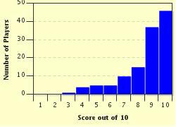
Avg Score
9 / 10
Plays
602
Awards
Top 10% Quiz
Last 3 plays: misstified (10/10), Guest 73 (6/10), Kabdanis (9/10).
-
Question 1 of 10
1. Tierra Del Fuego is an archipelago divided between two countries. One is Argentina, which is the other? Hint


Question 2 of 10
2. What is the name of the channel which separates the large island, Isla Grande de Tierra del Fuego, from the smaller islands in the archipelago? Hint


Question 3 of 10
3. The island of Isla Grande de Tierra del Fuego is the twenty-ninth largest island in the world and supports a number of industries like sheep farming and ecotourism. The extraction of natural gas and which other natural resource makes up a great portion of the economy? Hint


Question 4 of 10
4. The southernmost headland of the Tierra del Fuego archipelago, which marks the collision of the Atlantic and Pacific oceans, is known by what name? Hint


Question 5 of 10
5. One of the highest mountain peaks of the Andes Mountain range is found on the main island. It is named for a very famous naturalist. What is it called? Hint


Question 6 of 10
6. Tierra del Fuego's largest river, Rio Grande, originates on the western side of the main island and flows east to empty into a sea on the east coast. What is the name of the sea? Hint


Question 7 of 10
7. The Les Eclaireurs lighthouse was built on an islet in the channel east of the city of Ushuaia and is commonly referred to by which name? Hint


Question 8 of 10
8. The Alberto de Agostini National Park has been designated a Biosphere Reserve by UNESCO and has six glaciers along its north shore. What is the area containing these glaciers known as? Hint


Question 9 of 10
9. Tierra del Fuego has a subpolar oceanic climate in parts, a tundra climate in others and trees often grow into twisted shapes due to the extreme wind conditions. What are these trees commonly referred to as? Hint


Question 10 of 10
10. Which North American rodent, introduced in the 1940s, has become such a threat to the economy of the archipelago that an eradication program has been instituted to trap and kill them? Hint


(Optional) Create a Free FunTrivia ID to save the points you are about to earn:

arrow Select a User ID:
arrow Choose a Password:
arrow Your Email:


View Image Attributions for This Quiz

Most Recent Scores
Apr 15 2024 : misstified: 10/10
Mar 14 2024 : Guest 73: 6/10
Feb 29 2024 : Kabdanis: 9/10
Feb 29 2024 : zorba_scank: 10/10
Feb 29 2024 : TurkishLizzy: 10/10
Feb 29 2024 : snhha: 10/10
Feb 29 2024 : mcdubb: 10/10
Feb 29 2024 : CmdrK: 7/10
Feb 29 2024 : crossesq: 10/10

Score Distribution

quiz
Quiz Answer Key and Fun Facts
1. Tierra Del Fuego is an archipelago divided between two countries. One is Argentina, which is the other?

Answer: Chile

The archipelago of Tierra del Fuego, found on the southern tip of the continent, is separated from the mainland of South America by the Strait of Magellan. It consists of a large island named Isla Grande de Tierra del Fuego and a number of smaller islands. The territory is divided between Argentina, the eastern half and Chile the western half.
2. What is the name of the channel which separates the large island, Isla Grande de Tierra del Fuego, from the smaller islands in the archipelago?

Answer: Beagle

The Beagle Channel separates the Isla Grande from a number of smaller islands like Picton, Lennox and Nueva, Navarino, Hoste, Londonderry and Stewart. The channel was named after the ship HMS Beagle during its first survey of southern South America from 1826 to 1830. HMS Beagle was to complete three survey expeditions, two to South America and the third to Australia.
3. The island of Isla Grande de Tierra del Fuego is the twenty-ninth largest island in the world and supports a number of industries like sheep farming and ecotourism. The extraction of natural gas and which other natural resource makes up a great portion of the economy?

Answer: Petroleum

Petroleum and gas extraction make up 20% of the economic output of the Argentine side of the island. Cerro Sombrero is found on the Chilean side of the island, founded by the National Petroleum Company (ENAP) and is the main extraction centre on the island. In 1945, the Springhill No1 oil well on Isla Grande, was the first commercial oil producing deposit for Chile.
4. The southernmost headland of the Tierra del Fuego archipelago, which marks the collision of the Atlantic and Pacific oceans, is known by what name?

Answer: Cape Horn

Cape Horn was named for the Netherlands city Hoorn and is found on the Isla Hornos. It is the Drake Passage's northern boundary. Due to the opening of the Panama canal, few vessels need to navigate the horn and is often just used for recreational and competitive yachting.
5. One of the highest mountain peaks of the Andes Mountain range is found on the main island. It is named for a very famous naturalist. What is it called?

Answer: Mount Darwin

Charles Darwin, famous naturalist, joined the second survey of southern South America aboard the ship HMS Beagle and Mount Darwin was named after him by the ship's captain, in commemoration of Darwin's 25th birthday. Mount Darwin forms part of the Cordillera Darwin, a mountain range which forms part of the Andes. It was long thought to be the highest peak in the Andes mountain range, rising up 7,999 ft.

(The photo is of a Galapagos tortoise, to bring Darwin to mind.)
6. Tierra del Fuego's largest river, Rio Grande, originates on the western side of the main island and flows east to empty into a sea on the east coast. What is the name of the sea?

Answer: Argentine Sea

The Rio Grande river extends a total length of 240km. It flows from west to east and empties into the Argentine Sea. The city of Rio Grande sits at the river mouth. The Argentine Sea extends from Uruguay down to Tierra del Fuego and has a surface of approximately a million square kilometres.

It is a highly temperate sea as it receives the cold Falkland Current from the south and the warmer Brazil Current from the north.
7. The Les Eclaireurs lighthouse was built on an islet in the channel east of the city of Ushuaia and is commonly referred to by which name?

Answer: Lighthouse at the End of the World

The Les Eclaireurs Lighthouse is known to the Argentines as the "Lighthouse at the End of the World". It is automated and has electricity supplied to it via solar panels.

Another lighthouse, the San Juan de Salvamento lighthouse, is often incorrectly referred to by the same nickname, due to a Jules Verne novel "The Lighthouse at the End of the World". This lighthouse is found further east on the Isla de los Estados.
8. The Alberto de Agostini National Park has been designated a Biosphere Reserve by UNESCO and has six glaciers along its north shore. What is the area containing these glaciers known as?

Answer: Avenue of Glaciers

The Alberto de Agostini National Park is situated on the Chilean side of Tierra del Fuego. The six medium sized glaciers extend from the Cordillera Darwin. The glaciers are named Espaņa, Romanche, Alemania, Italia, Francia and Holanda.
9. Tierra del Fuego has a subpolar oceanic climate in parts, a tundra climate in others and trees often grow into twisted shapes due to the extreme wind conditions. What are these trees commonly referred to as?

Answer: Flag trees

Temperatures in Tierra del Fuego can average from a maximum of 14 degrees to a minimum of 5 degrees celsius in the Summer months and 4 degrees to -2 degrees in the Winter months. The archipelago has intense winds blowing at an average of 100km/h from a predominantly south/western direction. This has caused the trees to grow with their leaves and branches in a flag/pendant shape.
10. Which North American rodent, introduced in the 1940s, has become such a threat to the economy of the archipelago that an eradication program has been instituted to trap and kill them?

Answer: Beaver

Both the governments of Argentina and Chile are trying to eradicate the North American beaver from Tierra del Fuego due to the devastation they cause. These rodents were introduced in 1946 to try and establish a fur trading industry. The fact that there are no natural predators on the island has caused the beaver population to remain unchecked for decades.
Source: Author kino76

This quiz was reviewed by FunTrivia editor spanishliz before going online.
Any errors found in FunTrivia content are routinely corrected through our feedback system.
4/16/2024, Copyright 2024 FunTrivia, Inc. - Report an Error / Contact Us