FREE! Click here to Join FunTrivia. Thousands of games, quizzes, and lots more!
Quiz about The Magic of Suriname

The Magic of Suriname Trivia Quiz


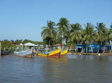
Most of us have preconceptions of what a place might be like, but I was amazed by the stunning beauty and majesty - indeed, the magic - of Suriname.

A photo quiz by VegemiteKid. Estimated time: 3 mins.
  1. Home
  2. »
  3. Quizzes
  4. »
  5. Geography Trivia
  6. »
  7. South America
  8. »
  9. Suriname

Author
VegemiteKid
Time
3 mins
Type
Photo Quiz
Quiz #
390,509
Updated
Dec 03 21
# Qns
10
Difficulty
Easy
Avg Score
9 / 10
Plays
184
Awards
Top 35% Quiz
-
Question 1 of 10
1. The Independent Republic of Suriname had a name change on November 25, 1975. Reflecting its colonial background, what was its name before this change? Hint


Question 2 of 10
2. The Amazon basin just touches the southern edge of Suriname. From the peaks of the granite Mount Kasikasima, you'd get a stunning view over the 'what' of the Amazon forest? Hint


Question 3 of 10
3. Suriname, in common with parts of the South Eastern United States, has languages that reflect the mixed heritage of its speakers, such as the Saramaccan people. Over time they incorporated speech elements of the Portuguese, Jewish and English people in the area to come up with their special patois. By what generic name is such a language known? Hint


Question 4 of 10
4. All Suriname's eight species of what can be found at the Raleighfalls, located on the spectacular Coppename River? Hint


Question 5 of 10
5. The Suriname, Corantijn, and Marowijne are rivers that drain the rain forests of the Amazon Basin into what ocean? Hint


Question 6 of 10
6. Located on the Nickerie river, the Blanche-Marie waterfalls were discovered by Lieutenant Van Drimmelen in 1897. For whom did he name them? Hint


Question 7 of 10
7. Created by the construction of the Afobaka Dam, the largest lake in Suriname is the Brokopondo Reservoir, a man-made lake whose main purpose is what? Hint


Question 8 of 10
8. One of the first illustrated accounts of the natural history of Suriname was by Maria Merian, a German woman whose passion for accuracy meant she was what? Hint


Question 9 of 10
9. The climate of Suriname lends itself to the production of crops such as sugar. In a foregone era, hundreds of plantations existed along what was known as the Sugar ____? Hint


Question 10 of 10
10. Having the appearance of a single piece of rock, the Voltzberg is a monolith in what World Heritage listed area? Hint


(Optional) Create a Free FunTrivia ID to save the points you are about to earn:

arrow Select a User ID:
arrow Choose a Password:
arrow Your Email:


View Image Attributions for This Quiz

Most Recent Scores
Feb 28 2024 : klrunning: 8/10
Feb 27 2024 : Guest 175: 7/10

Quiz Answer Key and Fun Facts
1. The Independent Republic of Suriname had a name change on November 25, 1975. Reflecting its colonial background, what was its name before this change?

Answer: Dutch Guiana

The official language of Suriname is Dutch, reflecting its status as a plantation colony of the Netherlands from the 16th century until 1975, when it gained its independence.

The Guianas (usually recognised as French Guiana, Guyana (aka British Guiana) and Suriname) were populated by scattered bands of Arawak Indians, closely related to native peoples of the Caribbean islands. With the arrival of European explorers, significant exploration and colonisation of this area took place.

The picture is of clogs, a traditional footwear of the Netherlands.
2. The Amazon basin just touches the southern edge of Suriname. From the peaks of the granite Mount Kasikasima, you'd get a stunning view over the 'what' of the Amazon forest?

Answer: Rooftops

The Surinamese Rainforest 'rooftop' is comprised of Brokopondo, Para and Sipaliwini, Suriname's three inland administrative districts. The area is almost entirely covered with tropical rainforest and the view from the top of any of the large granite mountains in the area consists primarily of the tops of trees, and more tops of trees!

A view over the rooftops of Toronto is seen here.
3. Suriname, in common with parts of the South Eastern United States, has languages that reflect the mixed heritage of its speakers, such as the Saramaccan people. Over time they incorporated speech elements of the Portuguese, Jewish and English people in the area to come up with their special patois. By what generic name is such a language known?

Answer: Creole

Descendants of contract labourers from India make up a significant proportion of the peoples of Suriname with the Maroons, (descendants of escaped slaves of African origin), also in significant numbers. Also descending from people of mainly African descent (but not from escaped slaves) are the Creole people.

Sranan is an English-based creole language, and is a widely used 'lingua franca' by which the diverse population communicates amongst itself.

The cookpots pictured are robust enough to allow cooking over a woodfire and are used by a Creole restaurant on the island of Reunion.
4. All Suriname's eight species of what can be found at the Raleighfalls, located on the spectacular Coppename River?

Answer: Monkeys

The monkeys of Suriname's jungles tend to live in troops of around 10 or a dozen. Some of the more interesting species are the red howling monkey, the Red-faced black spider monkey and the Guianan brown capuchin. It is estimated that only one species is currently threatened, most likely due to the relatively pristine condition of the rainforests.

The climate of Suriname is conducive to the production of bananas, often associated with monkeys. However, research shows that bananas cultivated for human consumption are not good for monkeys, as they are too sweet.
5. The Suriname, Corantijn, and Marowijne are rivers that drain the rain forests of the Amazon Basin into what ocean?

Answer: Atlantic

The total average catchment of all Suriname's rivers is a touch over 200000 sq km, with the average discharge into various bodies of water (not just the Atlantic) about 4800 cubic m/ second.

The Suriname coastline along the Atlantic Ocean is approximately 386 km. The Marowijne (also written as Maroni) River is on the east side of Suriname and forms a border with French Guiana. The Carib people of the Lesser Antilles settled at the mouth of the Marowijne and conquered the incumbent Arawaks.
6. Located on the Nickerie river, the Blanche-Marie waterfalls were discovered by Lieutenant Van Drimmelen in 1897. For whom did he name them?

Answer: Wife

The Blanche Marie Vallen (falls) are one of the largest waterfalls of Suriname and are located about 300 km from the capital of Suriname, Paramaribo. They span more than 120m across the Nickerie River in the highlands of the Amazon rainforest. More than 200 bird species make the area their home.

I hope the wedding rings pictured gave you a hint that the falls were named after Van Drimmelen's wife!
7. Created by the construction of the Afobaka Dam, the largest lake in Suriname is the Brokopondo Reservoir, a man-made lake whose main purpose is what?

Answer: Hydroelectric power

The Professor Doctor Ingenieur W. J. van Blommestein Meer (lake) is for obvious reasons more commonly known as Brokopondo Reservoir.

The Afobaka Dam was constructed between 1961 and 1964 creating the Brokopondo Reservoir, which is around 12km in length. The hydroelectric power created is produced from generators that convert the potential energy of fast-flowing water.

The powerboard pictured is one way the hydroelectric power can be used.
8. One of the first illustrated accounts of the natural history of Suriname was by Maria Merian, a German woman whose passion for accuracy meant she was what?

Answer: Meticulous in ensuring the insects she drew appeared on the correct plant in the correct season.

The importance of the work done by Maria Sibylla Merian (born April 2, 1647 in Frankfurt am Main, Germany) is that she didn't take artistic liberties with what she saw as many others of the same era did. She reproduced insects on the correct plants in the correct season with other natural aspects accurately recorded, meaning that there was a scientific integrity to her work not found in that of many of her contemporaries.

She and her daughter travelled to Suriname in 1699 with the intention of remaining for five years. However, she became ill and had to return home after two years, creating a legacy in the form of a book called "The Metamorphosis of the Insects of Suriname".

The changing leaves are indicative of the seasons, so important in the work of Maria Merian.
9. The climate of Suriname lends itself to the production of crops such as sugar. In a foregone era, hundreds of plantations existed along what was known as the Sugar ____?

Answer: Trail

The hundreds of sugar plantations were initially worked by slave labour. After the abolition of slavery, the plantation owners recruited Javanese immigrants to work in the sugar refineries. This was so successful that more followed and there is consequently a large influence of Javanese culture in the area. The Mariënburg refinery was one of the more important plantations as the Suriname rum still available in Paramaribo was first made there.

The trail pictured here is part of the Oregon trail, used for several decades by traders and farmers to move goods and people across the USA.
10. Having the appearance of a single piece of rock, the Voltzberg is a monolith in what World Heritage listed area?

Answer: Central Suriname Nature Reserve

The Central Suriname Nature Reserve was added to UNESCO's World Heritage list in November 2000 as a site of "exceptional universal value", the first time Suriname appeared on the World Heritage List.

The reserve is comprised of primary tropical forest of west-central Suriname. Animals that may be typically found in the area include jaguar, giant armadillo, giant river otter, and tapir as well as diverse plant species and many varieties of birds. The Voltzberg dominates the landscape and once climbed, provides a wonderful vista of the surrounding area.

The bullseye is the centre of the target - just as the Central Suriname Nature Reserve is just about smack-dab in the centre of Suriname!
Source: Author VegemiteKid

This quiz was reviewed by FunTrivia editor spanishliz before going online.
Any errors found in FunTrivia content are routinely corrected through our feedback system.
4/25/2024, Copyright 2024 FunTrivia, Inc. - Report an Error / Contact Us