FREE! Click here to Join FunTrivia. Thousands of games, quizzes, and lots more!
Quiz about Which Map Would You Use

Which Map Would You Use? Trivia Quiz


This quiz is about all the types of maps that you would use for certain situations. Most examples that are given are Australian. Enjoy!

A multiple-choice quiz by AW3404. Estimated time: 3 mins.
  1. Home
  2. »
  3. Quizzes
  4. »
  5. Geography Trivia
  6. »
  7. Names, Maps and Borders
  8. »
  9. Maps

Author
AW3404
Time
3 mins
Type
Multiple Choice
Quiz #
309,302
Updated
Jun 05 23
# Qns
10
Difficulty
Average
Avg Score
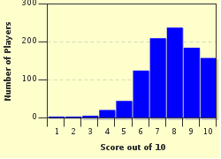
8 / 10
Plays
4358
Last 3 plays: piperjim1 (9/10), Dreessen (10/10), Guest 207 (8/10).
- -
Question 1 of 10
1. Which map would you use if you were asked to find the land heights of Australia? Hint


Question 2 of 10
2. In a situation where you need to get to someone else's house in the city, which map would you use? Hint


Question 3 of 10
3. You are in an Australian bush and you want to look for the shortest route to get to a town. What type of map is best? Hint


Question 4 of 10
4. This map would be perfect to study the territorial borders of the countries of the world. Name it. Hint


Question 5 of 10
5. What map would be ideal for getting to the nearest supermarket in Sydney, Australia? Hint


Question 6 of 10
6. Which map would you use to compare the population density in Australian cities? Hint


Question 7 of 10
7. In a situation where you need to compare different vegetations of Australia, which map would you use? Hint


Question 8 of 10
8. You want to see the Aboriginal tribe land of Australia before the English settlers came. Which map would you use? Hint


Question 9 of 10
9. If you want to find the rainfall predictions for tomorrow, which map would be perfect to use? Hint


Question 10 of 10
10. If you wanted a map to show the climate of Australia from 1900-1940, which map would be ideal? Hint


(Optional) Create a Free FunTrivia ID to save the points you are about to earn:

arrow Select a User ID:
arrow Choose a Password:
arrow Your Email:


Most Recent Scores
Mar 26 2024 : piperjim1: 9/10
Mar 25 2024 : Dreessen: 10/10
Mar 25 2024 : Guest 207: 8/10
Mar 21 2024 : Gispepfu: 10/10
Mar 18 2024 : Guest 174: 9/10
Mar 15 2024 : Guest 223: 10/10
Mar 12 2024 : Guest 31: 8/10
Mar 12 2024 : Guest 106: 9/10
Mar 11 2024 : AndySed: 10/10

Score Distribution

quiz
Quiz Answer Key and Fun Facts
1. Which map would you use if you were asked to find the land heights of Australia?

Answer: Physical

A physical map would be best because it would show the different land heights, normally with shades of brown and it would usually include a key or legend. Physical maps also show the natural features (e.g. rivers, mountains, lakes, etc.) in the area.
2. In a situation where you need to get to someone else's house in the city, which map would you use?

Answer: Street

A street map would be ideal because it would show the streets of the city and many public buildings. It would also show the structure of streets, and their names.
3. You are in an Australian bush and you want to look for the shortest route to get to a town. What type of map is best?

Answer: Topographic

A topographic map would be used in this situation because it shows both natural and man-made features, which enables you to get to the nearest town. Compared to physical maps, topographic maps are usually larger maps of smaller areas, so it is easier to locate smaller places than if you used a physical map.
4. This map would be perfect to study the territorial borders of the countries of the world. Name it.

Answer: Political

A political map shows country, state, and (in the case of the Australian Aborigines) tribal borders. It usually has different colours for countries that border one another, making it is easier to see each one.
5. What map would be ideal for getting to the nearest supermarket in Sydney, Australia?

Answer: Street

A topographic map might be useful in rural areas (and let's just imagine that there is a big supermarket in the middle of nowhere). However, street maps are best used in large cities like Sydney.
6. Which map would you use to compare the population density in Australian cities?

Answer: Thematic

In this type of situation, a thematic map would be used because it can show variations in population density. Of course, a choropleth map can also be used. The main difference is that a thematic map usually uses different colours, while a choropleth map normally uses shades of the same colour.
7. In a situation where you need to compare different vegetations of Australia, which map would you use?

Answer: Thematic

The main two types of maps that show comparison are thematic and choropleth maps (excluding physical maps, which show variations of land height and natural features.) In this situation, either type of map may be used.
8. You want to see the Aboriginal tribe land of Australia before the English settlers came. Which map would you use?

Answer: Political

Tribal borders, like other territory lines, are found on a political map. A political map can show current or historical borders.
9. If you want to find the rainfall predictions for tomorrow, which map would be perfect to use?

Answer: Weather

A weather map would show nearly everything about the climate for today or tomorrow. However, climate in the past is usually shown on a thematic or choropleth map, where comparisons of the climate in an area are shown.
10. If you wanted a map to show the climate of Australia from 1900-1940, which map would be ideal?

Answer: Choropleth

A choropleth map could show variations in climate for a length of time, or climate averages over a time period. If you were wondering why the answer is not "weather maps", that is because they normally show the weather forecast for the current days (or weeks).
Source: Author AW3404

This quiz was reviewed by FunTrivia editor Pagiedamon before going online.
Any errors found in FunTrivia content are routinely corrected through our feedback system.
Related Quizzes
1. 'Atlas'! It's a Map Quiz! Average
2. I Am Legend Average
3. Mapping 101 Average
4. Get Coordinated Tough
5. Mercator - Renaissance Mapmaker Average
6. Make Me a Map Tough
7. Topographic Maps Difficult

3/28/2024, Copyright 2024 FunTrivia, Inc. - Report an Error / Contact Us