FREE! Click here to Join FunTrivia. Thousands of games, quizzes, and lots more!
Quiz about Worth Their Salt

Worth Their Salt Trivia Quiz

"Salty" Places of the Earth

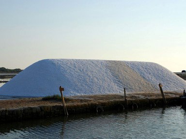
Inspired by one of the stops in the Globetrot Trivia 7 challenge, this quiz focuses on various places in the world that have a strong connection with the production and trade of salt, a commodity that in past times was often more valuable than gold.

A photo quiz by LadyNym. Estimated time: 3 mins.
  1. Home
  2. »
  3. Quizzes
  4. »
  5. Geography Trivia
  6. »
  7. Geography - Miscellany

Author
LadyNym
Time
3 mins
Type
Photo Quiz
Quiz #
424,336
Updated
May 31 26
# Qns
10
Difficulty
Easy
Avg Score
9 / 10
Plays
53
Last 3 plays: Guest 209 (7/10), debbitts (7/10), Guest 162 (5/10).
-
Question 1 of 10
1. Believed to be one of the earliest towns established in Europe, Solnitsata became wealthy by supplying salt to the Balkan region. Its ruins are found in Bulgaria, not far from what body of water? Hint


Question 2 of 10
2. Before it became a world-famous tourist attraction, the town of Hallstatt was the site of the world's oldest working salt mine. In what mountainous Central European country would you find it? Hint


Question 3 of 10
3. A large coastal wetland in southern France, the Camargue is known for its salt ponds frequented by flamingos and other bird species. This region is part of the delta of what major European river? Hint


Question 4 of 10
4. What county in North-West England with a feline association has been known since Roman times for the extraction and manufacturing of salt? Hint


Question 5 of 10
5. The island of Great Inagua has a history of salt production that goes back to the 17th century. It is part of what sovereign island country in the Caribbean, a former British colony? Hint


Question 6 of 10
6. The world's largest salt flat, the Salar de Uyuni, lies in southwestern Bolivia. Under the salt crust it holds a high concentration of what chemical element, an alkali metal widely used in batteries? Hint


Question 7 of 10
7. The Rann of Kutch is a huge area of seasonal salt marshes in the western Indian state of Gujarat that accounts for most of the country's salt production. It is adjacent to which desert, known for extremely high summer temperatures? Hint


Question 8 of 10
8. The extraction of salt from high-altitude lakes has been practiced for centuries in what autonomous region of China, also known as Xizang?

Answer: (One word. Roof)
Question 9 of 10
9. Salt has been mined for centuries in the extremely inhospitable surroundings of the Afar Depression, shared by which East African countries?


Question 10 of 10
10. What city in West Africa, whose historic centre is a UNESCO World Heritage Site, was once known as a major centre for the salt trade, and still depends on salt for much of its livelihood? Hint


(Optional) Create a Free FunTrivia ID to save the points you are about to earn:

arrow Select a User ID:
arrow Choose a Password:
arrow Your Email:


View Image Attributions for This Quiz

Most Recent Scores
Today : Guest 209: 7/10
Today : debbitts: 7/10
Today : Guest 162: 5/10
Today : Guest 98: 6/10
Today : DeepHistory: 10/10
Today : Taltarzac: 6/10
Today : Guest 109: 6/10
Today : Guest 80: 5/10
Today : Guest 71: 6/10

Quiz Answer Key and Fun Facts
1. Believed to be one of the earliest towns established in Europe, Solnitsata became wealthy by supplying salt to the Balkan region. Its ruins are found in Bulgaria, not far from what body of water?

Answer: Black Sea

Solnitsata ("salt works" in Bulgarian) was located in northeastern Bulgaria, near the modern city of Provadia in Varna Province. Founded around 4,700 BC, it was a fortified settlement that included a salt production facility: the walls around it were meant to protect the salt, which in ancient times was one of the most important commodities. This settlement, where pottery was also produced, flourished for about 500 years, accumulating considerable wealth (as witnessed by the gold objects found in the vicinity), but is believed to have been abandoned after it was nearly destroyed by an earthquake.

Salt extraction has been practiced for many centuries along the Black Sea coast of Bulgaria. The town of Pomorie, located south of Solnitsata, in Burgas Province, is home to the only salt museum in Southeast Europe. This outdoor museum showcases the production of sea salt through evaporation that developed in the area around the 5th century BC and still continues today. The tradition may have been connected with the much older settlement at Solnitsata.

The remains of the world's oldest salt exploitation site, dating from about 6,000 BC, were discovered in 1984 near the village of Lunca in northeastern Romania.
2. Before it became a world-famous tourist attraction, the town of Hallstatt was the site of the world's oldest working salt mine. In what mountainous Central European country would you find it?

Answer: Austria

Hallstatt is located in the Austrian state of Upper Austria (Oberösterreich), in the region of Salzkammergut, about 75 km (46.6 mi) southeast of Salzburg. This small but extremely photogenic town lies between the southwestern shore of the Hallstãtter See (Hallstatt Lake) and the slopes of the Dachstein massif. With its picture-postcard appearance and idyllic location, in recent times Hallstatt has become one of the symbols of overtourism, being frequently overrun by day trippers in search of photo opportunities. However, both the town and its surroundings boast a history that goes back thousands of years.

As its name suggests, the region of Salzkammergut ("salt domain" in German) is rich in salt mines, even though salt production is not as significant nowadays as it was in the past. The Hallstatt salt mine has been in use since the Bronze Age: its presence led to the development of the Hallstatt culture (1200 - 450 BC), a Proto-Celtic culture known for its advanced pottery and metalworking. The over 1,000 burials that have been found in the area have yielded many valuable artifacts attesting to the wealth achieved by the inhabitants of the ancient settlement through the exploitation of the salt mines. These artifacts - many of which shed light on the daily life of the miners - are on display in the Hallstatt Museum, established in 1884.

In 1997 the town and its surroundings were designated as a UNESCO World Heritage Site with the name of Hallstatt/Dachstein/Salzkammergut Cultural Landscape.
3. A large coastal wetland in southern France, the Camargue is known for its salt ponds frequented by flamingos and other bird species. This region is part of the delta of what major European river?

Answer: Rhône

Famous for its native breeds of horses and cattle, the Camargue is one of the world's most iconic wetland areas. It lies south of the historic city of Arles, between the Mediterranean Sea and the two arms of the delta of the river Rhône, which flows from Switzerland through southeastern France. The region is part of the French department of Bouches-du-Rhône. Covering an area of over 930 km² (360 sq mi), the Camargue (from a Celto-Ligurian word meaning "field covered with water") is a plain dotted with large brine lagoons, known in French as "étangs". The largest of these bodies of water is the Étang de Vaccarès, a renowned haven for many wild bird species (including a population of the greater flamingo), protected as a regional park since 1927.

Salt extraction in the Camargue began in antiquity, possibly even earlier; in the Middle Ages it was a major source of revenue for the Benedictine abbeys present in the region. Industrial salt production started in the 19th century, when the village of Salin-de-Giraud was established; significant saltworks are also found near the historic walled town of Aigues-Mortes, known for its connection to the Crusades in the 13th century. The salt flats of the Camargue often turn a vivid pink colour due to the presence of Dunaliella salina, a microscopic, salt-loving algae that produces carotenoids. Salt from the Camargue is highly prized, in particular the delicate crystals known as "fleur de sel" (flower of salt) that are harvested by hand during the summer from the surface of the water - making this gourmet product rather expensive.
4. What county in North-West England with a feline association has been known since Roman times for the extraction and manufacturing of salt?

Answer: Cheshire

Evidence of salt production dating from the Neolithic and the Bronze and Iron Ages has been found in various parts of England. What is now the ceremonial county of Cheshire became the centre of the salt industry in Britain already in Roman times, when salt began to be mined around present-day Middlewich - which the Romans called Salinae because of its abundant salt deposits. The "-wich" suffix found in the name of four Cheshire towns historically associated with salt production (Middlewich, Nantwich, Northwich and Leftwich), derived from the Latin "vicus" (place), often denoted a settlement connected with a salt pit or a brine spring. These four towns are mentioned in the Domesday Book (1086), hinting at the importance of salt production for the economy of the region. The salt industry flourished in Middlewich for centuries, and is still alive today. as the town houses the headquarters of British Salt Ltd. The salt mined in Cheshire was exported all over the world through the port of Liverpool, which in the 19th century rose to global prominence.

Middlewich and the other three "wich" towns are located not far from Chester, a cathedral city and the historic county town of Cheshire, founded by the Romans in 70 AD as Deva Victrix; its English name comes from the Latin "castrum", meaning fort. The photo depicts the central Eastgate Street during the Christmas season.

The feline association mentioned in the question is, of course, a reference to the Cheshire Cat that appears in Lewis Carroll's "Alice's Adventures in Wonderland".
5. The island of Great Inagua has a history of salt production that goes back to the 17th century. It is part of what sovereign island country in the Caribbean, a former British colony?

Answer: Bahamas

Great Inagua is the second-largest island in the Bahamas, comprising the southernmost district of the Caribbean island country together with the much smaller, uninhabited, Little Inagua. The island lies about 89 km (55 mi) northeast of the eastern tip of Cuba. Though the Bahamas had formally become a Spanish possession in 1494, Great Inagua (whose name means "great eastern land" in the indigenous Lucayan language), like most of the other islands, was not settled for over a century, until the British took charge. The reefs around the island, however, had already become known as a danger to navigation, with a number of treasure-laden ships meeting their end there.

Small-scale salt extraction on Great Inagua began in the 17th century, but did not fully develop until the 19th century. Now the production of salt is the island's only true industry, as the main facility of the Morton Salt Company - quite familiar to Americans - has been located in Matthew Town, the island's capital and only harbour, since 1954. Endless expanses of salt - produced by the evaporation of seawater - cover much of Great Inagua's largely flat territory, characterized by all-round warm temperatures and low rainfall. The brine of the salt ponds is the ideal habitat for brine shrimp, an important food source for many bird species - including the West Indian flamingo, the Bahamas' national bird, which owes its vibrant pink colour to its diet. Both Inagua islands are famed birdwatching spots.

The Bahamas achieved independence from the UK in 1973. The Cayman Islands are a British Overseas Territory, while Guadeloupe is an overseas department of France, and the Dominican Republic (also a sovereign state) is a former Spanish colony.
6. The world's largest salt flat, the Salar de Uyuni, lies in southwestern Bolivia. Under the salt crust it holds a high concentration of what chemical element, an alkali metal widely used in batteries?

Answer: lithium

Located in the Daniel Campos Province of the Potosí Department of southwestern Bolivia, the Salar de Uyuni lies at an elevation of 3,656 m (11,995 ft) above sea level; it is part of the Altiplano, or Andean Plateau. With an area of about 10,582 km² (4,087 sq mi), it is covered by an 8-m (26-ft), flat layer of salt formed by the progressive desiccation of seven lakes. This crust covers a brine pool that contains an exceptionally high amount of lithium - close to 22% of the world's resources of this alkali metal, essential in the manufacturing of batteries. The Salar de Uyuni is estimated to contain 10 billion tonnes (11 billion short tons) of salt, which is extracted by workers belonging to a cooperative based in the nearby town of Colchani.

Besides its economic significance as a major source of salt and other valuable minerals in chloride form, the Salar de Uyuni is also one of the most effective calibration sites for Earth-observing satellites due to its extremely uniform terrain and clear skies. In the past few decades the Salar has also become a popular tourist destination, with unique attractions such as several hotels almost entirely built of salt blocks and an antique train cemetery. It has also been used as a film location - most notably for "Star Wars: The Last Jedi" (2017).

Potassium is also an alkali metal (Group 1 of the periodic table), while magnesium and barium are alkaline earth metals (Group 2).
7. The Rann of Kutch is a huge area of seasonal salt marshes in the western Indian state of Gujarat that accounts for most of the country's salt production. It is adjacent to which desert, known for extremely high summer temperatures?

Answer: Thar Desert

The Rann of Kutch lies in the northwest of the Indian subcontinent, straddling the border between India and Pakistan. Most of this vast area (26,000 km²/10,000 sq mi) of salt marshes - once part of an inland lake that was cut off from the Arabian Sea by tectonic movement - is located in the Kutch District of the Indian state of Gujarat. It is divided into the Great Rann, which borders the Thar Desert to the south, and the Little Rann, which extends towards the Gulf of Kutch on the Arabian Sea. The name of this region with unique ecological features comes from a Sanskrit word meaning salt flat or barren ground.

Covering an area of about 7,500 km² (2,900 sq mi), the Great Rann of Kutch is considered an extension of the Thar Desert. One of the world's largest salt deserts, it floods with standing water during the monsoon season: islets of higher ground known as "bets" provide shelter to the region's wildlife, which include the rare Indian wild ass and various antelope species. Although the Rann of Kutch lies mostly north of the Tropic of Cancer, it is known for being one of India's hottest areas, with summer temperatures reaching up to 50 °C (122 °F). Salt extraction is mainly carried out by a community of migrant farmers known as Agariyas, who work from October to June - in extremely challenging conditions - to harvest up to 76% of the salt produced in India.

The Rann of Kutch is a popular tourist destination, in particular during the three-month Rann Utsav festival that takes place every year from December to February in the salt-covered "White Desert". Famous for its traditional embroidery and other arts and crafts, the region also houses the ruins of Dholavira, a city of the Indus Valley Civilization.
8. The extraction of salt from high-altitude lakes has been practiced for centuries in what autonomous region of China, also known as Xizang?

Answer: Tibet

The world's highest plateau, the Tibetan Plateau has an average elevation of 4,380 m (14,370 ft), which explains its nickname of "Roof of the World". The Xizang (Tibet) Autonomous Region covers most of the plateau, which also includes parts of other regions of western China. The Tibetan Plateau is also rich in bodies of water, particularly lakes - some of which contain the headwaters of some of the major rivers of South, Southeast and East Asia. Tibet's high-altitude lakes are called "tso": the two largest ones, Qinghai Lake (China's largest lake) and Namtso (in the photo), are saline lakes. Namtso has the distinction of being the world's highest saltwater lake, with an elevation of of 4,718 m (15,479 ft); it covers an area of 1,900 km² (730 sq mi).

The extraction of lake salt has been practiced for centuries in Tibet, where nearly 500 saltwater lakes are found; many of them are held sacred by the local peoples. Salt is extracted from lake water by evaporation, using the same techniques employed in the extraction of sea salt. In the past, nomadic salt harvesters undertook long treks through dangerous territory, braving the region's harsh climate, to reach the sacred lakes where salt could be harvested and then traded for foodstuffs such as rice along an ancient trade route running from Tibet to Nepal and India.

The plight of a group of Tibetan salt harvesters has been chronicled in a documentary, "The Saltmen of Tibet" (1997), a joint Swiss-German production. Though this way of life is fading, salt extraction from brine - using a technique that is over 1,000 years old - is still practiced in Tibet's Markam County, along the river Lancang (the upper course of the Mekong).
9. Salt has been mined for centuries in the extremely inhospitable surroundings of the Afar Depression, shared by which East African countries?

Answer: Ethiopia, Eritrea and Djibouti

The Afar Depression (also known as Afar Triangle on account of its shape) lies in the Horn of Africa, at the junction of three tectonic plates - the Arabian, the Nubian and the Somali. This low-lying area, which contains the lowest point of the African continent (Lake Assal in Djibouti, shown in the photo), is part of the Great Rift Valley that extends through East Africa south to Mozambique. The territory of the Afar Depression, named after the Afar people who have inhabited it for centuries, is shared by Eritrea, Ethiopia and Djibouti. This region is mostly a desert, with the sole exception of the banks of the Awash River, its only watercourse; rainfall is extremely scarce, and year-round temperatures are among the highest on Earth.

About 1,200 km² (460 sq mi) of the Afar Depression are covered by thick salt deposits, from which bars of salt called "amoleh" were carved and used as currency from antiquity up to the early 20th century. Salt extraction is still the main economic activity in this inhospitable part of the world. The largest deposits are found around Lake Afrera in the Danakil Depression, in the northern part of the Afar Triangle. The area, however, is also high in volcanic activity: the eruption of the Nabro volcano in 2011 contaminated the salt deposits with sulfuric acid, rendering the salt inedible.
10. What city in West Africa, whose historic centre is a UNESCO World Heritage Site, was once known as a major centre for the salt trade, and still depends on salt for much of its livelihood?

Answer: Timbuktu

Located in central Mali, 20 km (12 mi) north of the Niger River, present-day Timbuktu is an impoverished city threatened by extremist groups and the encroachment of the Sahara Desert. The city is surrounded by sand dunes, with scarce rainfall and very high temperatures throughout the year. Due to the winds blowing south from the desert, especially during the winter months, the city streets are covered in sand. However, Timbuktu still boasts a number of landmarks that hark back to its golden age, when the city was annexed by the vast Mali Empire, becoming a major hub on the Saharan trade routes and an important centre for Islamic scholarship. Because of these reminders of a bygone era, built in the characteristic Sudano-Sahelian architectural style (such as the Sankoré Mosque in the photo), the historic centre of Timbuktu was designated as a UNESCO World Heritage Site in 1988.

In the Middle Ages, Timbuktu flourished thanks to gold and salt mining and its favourable position at the crossroads of North, West and Central Africa. The salt came mostly from the salt pan of Taghaza in northern Mali: it was cut in thick slabs and transported across the desert by caravans of thousands of camels as far as the Mediterranean coast. The mine was abandoned at the end of the 16th century and replaced by Taoudenni, a site 664 km (413 mi) north of Timbuktu. From there the salt - dug by hand from the bed of an ancient salt lake - is transported south to Timbuktu. Though nowadays transport is mainly carried out by trucks, the camel caravans known as "azalai" are still operated by Tuaregs from this extremely isolated place with a hellishly hot climate.
Source: Author LadyNym

This quiz was reviewed by FunTrivia editor agony before going online.
Any errors found in FunTrivia content are routinely corrected through our feedback system.
5/31/2026, Copyright 2026 FunTrivia, Inc. - Report an Error / Contact Us