FREE! Click here to Join FunTrivia. Thousands of games, quizzes, and lots more!
Quiz about Papua New Guinea  Unity in Diversity

Papua New Guinea - Unity in Diversity Quiz


Let's explore one of the most culturally, linguistically and geographically diverse nations in the world - Papua Niugini (to use their own name for themselves in the official language of Tok Pisin).

A photo quiz by looney_tunes. Estimated time: 3 mins.
  1. Home
  2. »
  3. Quizzes
  4. »
  5. Geography Trivia
  6. »
  7. Pacific Islands
  8. »
  9. Papua New Guinea

Author
looney_tunes
Time
3 mins
Type
Photo Quiz
Quiz #
345,891
Updated
Dec 03 21
# Qns
10
Difficulty
Average
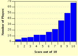
Avg Score
8 / 10
Plays
1024
Awards
Top 10% Quiz
Last 3 plays: Guest 24 (8/10), Guest 219 (8/10), Gregory53 (10/10).
-
Question 1 of 10
1. Papua New Guinea is located on the island of New Guinea, just north of Australia, seen at the bottom of this map. It is on the east half of the island, the west half of which is part of what country? Hint


Question 2 of 10
2. As this map shows, Papua New Guinea is located in a region that is prone to frequent earthquakes and which has many active volcanoes, highlighted in pink on the map. What is the nickname commonly given to this region? Hint


Question 3 of 10
3. As well as the main island region, Papua New Guinea includes a number of nearby islands. The furthest east of these, Bougainville, is geographically (although not politically) part of which if these island groups? Hint


Question 4 of 10
4. Port Moresby was a point of strategic significance during World War II, when the Japanese tried to capture it to establish an air and sea base that would help keep Australia from playing a significant role in the war. What body of water would have come under their control had they succeeded? Hint


Question 5 of 10
5. As this map shows, there is a large mountainous area running the length of the island of New Guinea, where you will find Mount Wilhelm, the highest point in Papua New Guinea. What is the name given to this mountain range? Hint


Question 6 of 10
6. This satellite photo shows the stark contrast in climate between Papua New Guinea and its nearest neighbour to the south, Australia. What is the name for the body of water which separates these two nations at the point where they are closest to each other? Hint


Question 7 of 10
7. Many young Australians (and some very fit but not so young ones) hike in the footsteps of the 19th century miners who dug for gold in the Yodda Kokoda goldfields, starting from Owers Corner, 50 km (30 mi) east of Port Moresby. What is the name of this route, made famous during World War II? Hint


Question 8 of 10
8. This map shows the mouth of the Fly River as it empties into the Gulf of Papua. What is the name given to this triangular spreading often seen at the mouth of a river due to sedimentary deposits? Hint


Question 9 of 10
9. Nearly three-quarters of Papua New Guinea's export earnings come from minerals. Which of these agricultural products is also part of a significant export industry? Hint


Question 10 of 10
10. Papua New Guinea features its national bird both on its official Coat of Arms (shown here) and on its flag. What bird is this? Hint


(Optional) Create a Free FunTrivia ID to save the points you are about to earn:

arrow Select a User ID:
arrow Choose a Password:
arrow Your Email:


View Image Attributions for This Quiz

Most Recent Scores
Apr 07 2024 : Guest 24: 8/10
Mar 06 2024 : Guest 219: 8/10
Mar 04 2024 : Gregory53: 10/10

Score Distribution

quiz
Quiz Answer Key and Fun Facts
1. Papua New Guinea is located on the island of New Guinea, just north of Australia, seen at the bottom of this map. It is on the east half of the island, the west half of which is part of what country?

Answer: Indonesia

The island of New Guinea lies in the region of the Pacific Ocean traditionally called Melanesia. It is the world's second-largest island, with Greenland being the largest. Historically, the western part of the island was a Dutch colony, while the eastern half was a German colony until World War I, when it came under Australian control. Papua New Guinea gained independence on 16 September 1975.

The western half of the island was annexed by Indonesia in 1969, and is usually referred to as Papua or West Papua (the names of the two provinces which constitute that half of New Guinea). You may also have heard the two regions called Irian Jaya and West Irian Jaya.
2. As this map shows, Papua New Guinea is located in a region that is prone to frequent earthquakes and which has many active volcanoes, highlighted in pink on the map. What is the nickname commonly given to this region?

Answer: Ring of Fire

The Pacific Ocean is surrounded by boundaries where oceanic plates are running into continental plates (I won't go into the details of names, as there are a lot of them). At the areas of contact, subduction (one plate moving under the other) causes stress on the rocks which leads to earthquakes.

It also frequently leads to mountain building, and to the formation of volcanically active regions where the crust is weakened. There are several plates that meet near Papua New Guinea, which means it is subject to frequent earthquakes, and the tsunamis that often accompany them. Active volcanoes include Ulawun, on the island of New Britain, considered potentially one of the most dangerous volcanoes in the region; Rabaul, also on New Britain, which destroyed the city of Rabaul in 1937 and again in 1994; Lamington, in the New Guinea province of Oro, whose 1951 eruption killed 3,000 people; and Manam Motu, which erupted in 2004 and forced the island formed by its cone to be abandoned.
3. As well as the main island region, Papua New Guinea includes a number of nearby islands. The furthest east of these, Bougainville, is geographically (although not politically) part of which if these island groups?

Answer: Solomon Islands

Bougainville has unsuccessfully proclaimed its independence several times in the past, and is currently considered an autonomous region within Papua New Guinea. This gives them a degree of self-government, and the possibility of a future referendum establishing full independence. Bougainville's extensive copper and gold deposits have made it a hotly-disputed area. Bougainville is part of the Solomon Islands archipelago, and belongs to the Solomon Islands tropical rainforest ecoregion.
4. Port Moresby was a point of strategic significance during World War II, when the Japanese tried to capture it to establish an air and sea base that would help keep Australia from playing a significant role in the war. What body of water would have come under their control had they succeeded?

Answer: Gulf of Papua

Port Moresby lies near the eastern end of the Gulf of Papua, which carves a semicircular chunk out of the southern side of the island of New Guinea. The area had long been settled by the Motu-Koitabu people, and was an established trade centre when Captain John Moresby arrived and named it after his father, Admiral Sir Fairfax Moresby, in 1873.

In 1942, Port Moresby was a major staging point for the movement of Allied troops around the South Pacific, and an obvious target for the Japanese. Had they been able to capture it, communication lines would have been severely disrupted. An amphibious assault was prevented by the Battle of the Coral Sea (May 4-8); the Battle of Midway (June 4-7) effectively made a second attempt out of the question.

They then turned to land-based attempts to capture Port Moresby, and suffered their first major setback in the Battle of Milne Bay, which would have allowed them to proceed over relatively easy coastal terrain to reach their target.
5. As this map shows, there is a large mountainous area running the length of the island of New Guinea, where you will find Mount Wilhelm, the highest point in Papua New Guinea. What is the name given to this mountain range?

Answer: New Guinea Highlands

The Highlands are also called the Central Range and the Central Cordillera (a name for a mountain range that runs roughly along a coastline, such as the Andes in South America). They are an area of immense ecological diversity - lower levels are tropical, much of the region is montane forest with a large variety of wildlife, and the higher areas are sub-alpine grassland with lots of different plants, but fewer animals than the lower areas (and experiencing occasional snowfalls, despite the proximity of the equator). Many of the river valleys between the mountains are cultivated and have relatively dense population settlements, but the mountain valleys are filled with small tribal settlements. The terrain makes travelling through the region difficult, and there is little in the way of transport infrastructure - many areas are only readily reached by air. It is believed that many as-yet-undiscovered species of plants and animals may be lurking in the highlands.

Mount Wilhelm is an extinct volcano with a crater lake which is a popular, albeit rather dangerous, climb. While it is not the highest mountain on the island of New Guinea (the Indonesian section has higher ice-capped peaks), it is sometimes cited as the highest mountain in Oceania, on the (somewhat tenuous) argument that the other peaks are part of Asia since Indonesia is an Asian country.
6. This satellite photo shows the stark contrast in climate between Papua New Guinea and its nearest neighbour to the south, Australia. What is the name for the body of water which separates these two nations at the point where they are closest to each other?

Answer: Torres Strait

The lush green vegetation of Papua New Guinea can also be seen in the northernmost part of the Cape York Peninsula, and near the edge of the Gulf of Carpentaria (seen in the photo, which is looking south, as being the curve in the coast of Australia), but the dry red centre for which Australia is best known is also clearly visible. To the east (left in the photo) lies the Coral Sea, to the west (right in the photo) is the Arafura Sea.

The Torres Strait is less than 150 km (90 mi) wide at its narrowest point, and is filled with islands that make navigating it extremely hazardous. There have been times in the past when sea level was lower than it is today, and New Guinea was directly attached to the Australian mainland, which explains why they share many of the same unusual fauna such as kangaroos and possums.
7. Many young Australians (and some very fit but not so young ones) hike in the footsteps of the 19th century miners who dug for gold in the Yodda Kokoda goldfields, starting from Owers Corner, 50 km (30 mi) east of Port Moresby. What is the name of this route, made famous during World War II?

Answer: Kokoda Track

The Kokoda Track (also called the Kokoda Trail) runs for about 100 km (60 mi) through difficult mountain terrain, much of which can only be traversed on foot. During World War II, the Japanese planned to invade Port Moresby overland, starting from their base in Gona. Allied troops, mostly Australian, engaged the Japanese in a series of battles along the Kokoda Track between July and November of 1942, eventually forcing the Japanese to retreat to their Gona base.

This battle has come to be seen as one in which Australian troops, for the first time in their short nationhood, defended their country against foreign invasion (although most historians do not now believe that was actually likely to have occurred), and has developed a mythic significance alongside the battle of Gallipoli in World War I. Walking the track is often done as a tribute to family members who fought (and often died) there.

In the first decade of the 21st century, conflict has arisen over the track for a number of reasons: local residents do not feel they are getting a fair share of the money paid by trekkers; one village wants to allow copper mining which would mean that a portion of the track would need to be rerouted; at another spot there is a proposal for a gold mine; Australian groups are pushing for the establishment of an Australian Heritage designation that would preserve it as is; and a number of people have died when attempting the trek due to the dangerous terrain, leading to calls for more stringent controls over allowing people to attempt the journey.
8. This map shows the mouth of the Fly River as it empties into the Gulf of Papua. What is the name given to this triangular spreading often seen at the mouth of a river due to sedimentary deposits?

Answer: Delta

A delta is formed as a river slows down when nearing the end of its course, and the suspended sediment is deposited. This eventually forces the river to carve a slightly different channel. Over time, a widened triangular opening is formed.

The Fly River is the second-longest river in Papua New Guinea and (as of the start of the 21st century) the largest river by volume in the world that does not have a single dam anywhere in its catchment area. Its main tributaries are the Strickland and the Ok Tedi, both of which have been involved with mining pollution incidents which cause concern for the Fly River. The Fly River was named after the ship which Francis Blackwood commanded when he discovered its mouth in 1842; it was first explored by steamboat in 1876 by Luigi D'Albertis, who managed to travel more than 900 km (550 mi) upstream. The river forms part of the boundary with Indonesia, which means there is a slight S-bend in the otherwise straight border along the 141E line of longitude.

The islands in the estuary are highly fertile, and the inhabitants grow sugar cane, plantain, breadfruit and coconuts, among other products. Most of them are engaged in subsistence farming, as is the case for many Papua New Guineans.
9. Nearly three-quarters of Papua New Guinea's export earnings come from minerals. Which of these agricultural products is also part of a significant export industry?

Answer: Coffee

Papua New Guinea is one of the top twenty coffee-exporting nations - in 2007 it ranked 17th, with over 75,000 tonnes of coffee exported. Other significant export crops include cocoa, palms (coconut palms for copra, oil palms for their oil) and tea. Most Papua New Guineans rely on subsistence farming, with only a small portion involved in the market sector, most of which is controlled by foreign investors. Copper and gold mining are among the most important of these industries.

The timber industry is also thriving, somewhat controversially, as deforestation is seen as a looming issue.

In the last quarter of the 20th century, nearly a quarter of the country's rainforests were severely damaged, and the native flora and fauna have suffered accordingly.
10. Papua New Guinea features its national bird both on its official Coat of Arms (shown here) and on its flag. What bird is this?

Answer: Bird-of-Paradise

Also called the kumul in Tok Pisin, the Raggiana Bird-of-Paradise is a large member of the Paradisaeidae family, measuring up to 30 cm (12 in) long. As the image shows, it is a brown or reddish-brown color; the male has a yellow crown and a yellow collar between its bright green throat and its chest. The large feathers at the side of the body (called flank plumes) are red to orange, depending on the subspecies. Females don't get to display any of the pretty colours.

Papua New Guinea's national rugby league football team is nicknamed the Kumuls.
Source: Author looney_tunes

This quiz was reviewed by FunTrivia editor Tizzabelle before going online.
Any errors found in FunTrivia content are routinely corrected through our feedback system.
Related Quizzes
This quiz is part of series Written for the Bus Ride:

You think you can write just one, but it turns out that writing quizzes suitable for being visited by the tourists on the Bus Ride is addictive - there's just so much to find out!

  1. Saint Vincent and the Grenadines Average
  2. Barbados, Land of the Flying Fish Average
  3. Calypso Country - Trinidad and Tobago Average
  4. "The Land, the People, the Light" - Saint Lucia Average
  5. A Provincial Tour of Zimbabwe Average
  6. Republic of Benin, Formerly Dahomey Average
  7. The Landlocked Kingdom of Lesotho Average
  8. Honduras: "Free, Sovereign and Independent" Average
  9. Exploring Kosovo Average
  10. Democratic Republic of Sao Tome and Principe Average
  11. "We Stand With God" in Vanuatu Average
  12. They Came to Baghdad Average

4/26/2024, Copyright 2024 FunTrivia, Inc. - Report an Error / Contact Us