FREE! Click here to Join FunTrivia. Thousands of games, quizzes, and lots more!
Quiz about The Big One

The Big One Trivia Quiz


The world's biggest island, or its smallest continent, depending on whom you ask, has a lot to offer the prospective tourist. If you don't already know these sites, you can learn about them and plan to include them in your next visit.

A multiple-choice quiz by looney_tunes. Estimated time: 4 mins.
  1. Home
  2. »
  3. Quizzes
  4. »
  5. Geography Trivia
  6. »
  7. Australia

Author
looney_tunes
Time
4 mins
Type
Multiple Choice
Quiz #
345,257
Updated
Dec 03 21
# Qns
10
Difficulty
Average
Avg Score
7 / 10
Plays
5854
Awards
Top 5% quiz!
Last 3 plays: daisygirl20 (9/10), Guest 62 (10/10), Guest 175 (8/10).
- -
Question 1 of 10
1. The world's largest coral reef system lies off the northeast coast of Queensland, in the Coral Sea. You will want to bring along your scuba diving gear when you visit which of these tourist hot spots? Hint


Question 2 of 10
2. Travelling down the east coast of Australia, we arrive at the city of Katoomba, in the Blue Mountains about 110 km (68 mi) west of Sydney. From here there are lots of interesting thing to see, but we are going to visit one of New South Wales's best known rock formations. Which of these can be found near Katoomba, overlooking the Jamison Valley? Hint


Question 3 of 10
3. Mount Kosciuszko is the highest mountain on the mainland of Australia. In which of these mountain ranges, also known as the site of the nation's largest hydro-electric power scheme, constructed between 1949 and 1976, will you see Mount Kosciuszko? Hint


Question 4 of 10
4. Along Victoria's Great Ocean Road you can see the amazing limestone stacks called the Twelve Apostles. The waters of what ocean carved these out of the coastal limestone cliffs? Hint


Question 5 of 10
5. It is well known that much of Australia is desert, with a relatively narrow coastal strip where most of the population is clustered. Which of these is NOT to be found in its spectacular Red Centre? Hint


Question 6 of 10
6. If you've answered enough trivia questions, you probably know that there is a very large region in southern Australia called the Nullarbor. What kind of feature is it? Hint


Question 7 of 10
7. Heading way offshore, we come to Australia's Antarctic territories. On which of these islands can tourists see one of the only two active volcanoes in Australian territory? Hint


Question 8 of 10
8. Western Australia has a large region that was named because of its similarity to a diamond-mining region in South Africa. Which of these is the name for one of Australia's hottest areas? Hint


Question 9 of 10
9. If I told you the former name of Nitmiluk National Park, you would have no trouble recognizing the Northern Territory river responsible for creating this gorge about 240 km (150mi) southeast of Darwin. Which of these rivers would you be cruising down to take your photos? Hint


Question 10 of 10
10. You knew we had to visit the big sandstone rock known as Uluru (formerly Ayers Rock). In what nearby town, featured in the title of a book by Nevil Shute, will you most likely join the tour that will take you to see Uluru? Hint


(Optional) Create a Free FunTrivia ID to save the points you are about to earn:

arrow Select a User ID:
arrow Choose a Password:
arrow Your Email:


Most Recent Scores
Today : daisygirl20: 9/10
Oct 09 2024 : Guest 62: 10/10
Oct 09 2024 : Guest 175: 8/10
Oct 08 2024 : Lascaux: 9/10
Sep 29 2024 : orinocowomble: 8/10
Sep 25 2024 : turtle52: 10/10
Sep 25 2024 : Guest 165: 6/10
Sep 20 2024 : Kiwikaz: 8/10
Sep 19 2024 : Guest 1: 7/10

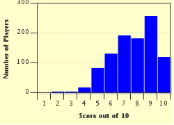
Score Distribution

quiz
Quiz Answer Key and Fun Facts
1. The world's largest coral reef system lies off the northeast coast of Queensland, in the Coral Sea. You will want to bring along your scuba diving gear when you visit which of these tourist hot spots?

Answer: Great Barrier Reef

While Australians might be tempted to tout it as the Big Barrier Reef, in line with such other tourist attractions as the Big Banana, the Big Koala, and many more, its official name is the Great Barrier Reef. Stretching for over 2600 km (1600 miles), and composed of hundreds of individual coral reefs and islands, the reef is a structure created by coral polyps.

The coral reproduces by budding to create new organisms growing atop the skeletons left from dead ancestors. Its continued growth has been threatened in recent times by periodic increases of the invasive crown-of-thorns starfish (which feasts on coral) and by warming ocean temperatures.

Increased water temperature leads to coral bleaching as the polyps lose the ability to sustain their symbiotic relation with the photosynthesizing protozoa that normally live in their tissue, and provide their color.
2. Travelling down the east coast of Australia, we arrive at the city of Katoomba, in the Blue Mountains about 110 km (68 mi) west of Sydney. From here there are lots of interesting thing to see, but we are going to visit one of New South Wales's best known rock formations. Which of these can be found near Katoomba, overlooking the Jamison Valley?

Answer: The Three Sisters

The Three Sisters are usually viewed from Echo Point, a few kilometres south of Katoomba. They are three sandstone columns formed by erosion (which continues - you can see the newly exposed rock, which has a lighter color than the surface parts which have been exposed for a longer time), given the names of Meehni, Wimlah and Gunnedoo. A story created for the benefit of tourists says that they were three sisters who fell in love with members of a neighboring, and unfriendly, tribe. In the war that followed after their lovers had captured them, they were turned to stone to prevent injury; the only one who could then turn them back to living people was killed in battle. Nice story, but not actually a native legend as claimed - it first appeared somewhere around the 1930s.

From Echo point, you can descend the "Giant Stairway", a set of steps set into the mountainside, down to the valley floor, then walk for 1-2 hours to get to the base of Katoomba Falls, where you can hop on to the Katoomba Scenic Railway for a restful ride back to the top. Unless, of course, you would rather retrace your steps on foot!
3. Mount Kosciuszko is the highest mountain on the mainland of Australia. In which of these mountain ranges, also known as the site of the nation's largest hydro-electric power scheme, constructed between 1949 and 1976, will you see Mount Kosciuszko?

Answer: The Snowy Mountains

The Snowy Mountains, part of the Australian Alps and the Great Dividing Range, contain all five of mainland Australia's highest peaks, and are the centre of what little alpine skiing is available in this generally warm and dry country. The Snowy Mountains Hydroelectric scheme was, at the time, the largest engineering project ever completed in Australia.

Its sixteen dams and seven power stations, along with extensive tunnels and pipelines, allow it to generate about two-thirds of the renewable electricity on the national power grid, as well as providing valuable irrigation for farms and controlling water flow in the Murray and Murrumbidgee Rivers. Possibly even more significantly, much of the requisite labor force was provided by European immigrants, many of whom stayed on and started the cultural diversification of Australia in the second half of the 20th century.
4. Along Victoria's Great Ocean Road you can see the amazing limestone stacks called the Twelve Apostles. The waters of what ocean carved these out of the coastal limestone cliffs?

Answer: Indian Ocean

Although most Australians refer to this area of water as the Southern Ocean, that Ocean actually ends well south of the Australian coastline. This part of the coast is on the Indian Ocean. The waters often produce serious winds, coming up from the Antarctic, arriving at the southern coast of Australia to produce pounding waves which initially carved caves in the cliff faces. Eventually the caves that were precursors to the Twelve Apostles were eaten through to form arches, and when the top connections collapsed, isolated stacks were left standing offshore.

It is not sure exactly how many there once were - there were nine stacks at the start of the 20th century, and continued erosion has led to the collapse of one of these, so that there are now (2012) only eight left.

They were originally called the Sow and Piglets, before being renamed the Apostles in the 1920s, a name which turned into the Twelve Apostles, despite the numerical mismatch. Because they are so close together, many tourists are happy to simply observe them from the shore, but helicopter rides for closer inspection are available.
5. It is well known that much of Australia is desert, with a relatively narrow coastal strip where most of the population is clustered. Which of these is NOT to be found in its spectacular Red Centre?

Answer: Gobi Desert

Australia's largest desert is the Great Victoria Desert, found in Western Australia and South Australia. It is the most southerly of the major deserts. The Simpson Desert, in Northern Territory, Queensland and South Australia, is Australia's fourth-largest desert, and is distinguished by the presence of the world's longest parallel sand dunes, the largest of which is nicknamed Big Red.

It should be noted that the identification of separate deserts is somewhat arbitrary, and there are no clear boundaries to most of them.

Other regions are identified as the following deserts (in decreasing order of size): Great Sandy, Tanami, Gibson, Little Sandy, Strzlecki, Sturt Stony, Tirari and Pedirka.
6. If you've answered enough trivia questions, you probably know that there is a very large region in southern Australia called the Nullarbor. What kind of feature is it?

Answer: Plain

The Nullarbor Plain is named for its most obvious feature - a distinct lack of large vegetation. (Nullarbor is Latin for No Tree.) It extends along the southern coast of Australia, extending north as far as the Great Victoria Desert, and is one of the largest limestone structures in the world. Crossing this 1100 km (700 mi) stretch of land with few trees and less water was a serious challenge for early European settlers.

In fact, even with cars it was quite a challenge until fairly recently - the Eyre Highway was finally completely sealed in 1976, removing the last dirt track stretches of the crossing.

A telegraph line was laid across the Nullarbor in 1877, and the Trans-Australian Railway was constructed in 1917 (and rebuilt in 1970, to make the line more stable).

The famous transcontinental train called the Indian-Pacific uses this line - it's a great way to see the landscape without having to worry about possible car troubles!
7. Heading way offshore, we come to Australia's Antarctic territories. On which of these islands can tourists see one of the only two active volcanoes in Australian territory?

Answer: Heard Island

Heard Island is home to Mount Mawson, the highest peak in any Australian territory, and an active volcano. The other active volcano can be found on nearby McDonald Island. Heard Island and the McDonald Islands are among the most isolated places on earth - they are over 3800 km (2400 mi) from the closest point on the Australian mainland (in Western Australia), and are almost exactly the same distance from the island of Madagascar.

The closest large landmass is Antarctica, a mere 1600 km (1000 mi) away, but the French-owned Desolation Islands are the closest inhabited region. You won't be able to land a boat on Heard Island, so you'd better plan on having a helicopter on-board the ship you use to travel there. That is how the first known landing was made in 1971, and the helicopter will allow you to fly over the volcano for a closer look.
8. Western Australia has a large region that was named because of its similarity to a diamond-mining region in South Africa. Which of these is the name for one of Australia's hottest areas?

Answer: Kimberley

The South African Kimberley is the capital city of Northern Cape province, and is a centre of the diamond mining industry. The Western Australian Kimberley was named because its appearance was similar to that of Kimberley diamond fields - the subsequent discovery of diamonds to be mined was serendipitous.

The Kimberley contains a number of steep-sided mountains, with dramatic gorges down which you can travel by canoe or raft, depending on who organises your trip. Of course, it's not all mountains - the coastal town of Broome is a major centre for the pearling industry. With daily temperatures that almost always exceed 30C (84F) even in midwinter, the Kimberley is too hot for me, but there are those who thrive in the heat.
9. If I told you the former name of Nitmiluk National Park, you would have no trouble recognizing the Northern Territory river responsible for creating this gorge about 240 km (150mi) southeast of Darwin. Which of these rivers would you be cruising down to take your photos?

Answer: Katherine River

Actually, cruising gives rather the wrong impression - you can navigate the Katherine River Gorge (found in the region that used to be called the Katherine River National Park) in canoes or rafts, guided by professionals on tours that can be booked in the nearby town of Katherine.

It is actually thirteen separate gorges, connected in times of plentiful water flow, but isolated from each other in the dry season. During the dry season they say you can swim with safety, and that the crocodiles in the river pose no danger - the dangerous saltwater crocodiles that enter the river during the wet season all get captured and removed at the start of the dry season, leaving only the harmless freshwater type. I don't believe it!
10. You knew we had to visit the big sandstone rock known as Uluru (formerly Ayers Rock). In what nearby town, featured in the title of a book by Nevil Shute, will you most likely join the tour that will take you to see Uluru?

Answer: Alice Springs

Nevil Shute's novel "A Town Like Alice" is not set in Alice Springs. The central character yearns to change the town where she settles after the war-time part of the story into 'a town like Alice', as locals generally refer to the town. The Alice Springs library is officially named after him, in recognition of the publicity the novel provided.

Uluru is about 450 km (280 mi) away from Alice Springs by road. It is a sacred site for the Anunga people, who guide tourists to show them the local bush foods, native animals and cave paintings. They also help them avoid disturbing sites of spiritual significance. Climbing the rock has been a popular tourist activity, but it is increasingly discouraged, for both cultural and environmental reasons. The arkose sandstone which makes up Uluru changes color as the sunlight hits it at different angles - it is spectacularly red at sunrise and sunset, and a more ordinary reddish-brown color during most of the day.

While you are here, you might also like to visit nearby (relatively) Kata Tjuta, formerly called the Olgas, which show a similar startling color change.
Source: Author looney_tunes

This quiz was reviewed by FunTrivia editor Tizzabelle before going online.
Any errors found in FunTrivia content are routinely corrected through our feedback system.
Related Quizzes
This quiz is part of series A Taste of Australia:

A sample of my quizzes with an Australian focus.

  1. "We Can Be Heroes" - Phil Olivetti Average
  2. Aussie Rules Mascot Melee Average
  3. Scandals in Australian History Average
  4. Eltham: Gateway to Melbourne's Green Wedge Average
  5. And Then There Were None Average
  6. Streets of Gold Average
  7. How I Spent My Summer Vacation Average
  8. VFL to AFL and On Easier
  9. The Big One Average
  10. Australia's Convict Heritage Average
  11. The All-Aussie Bunyip Average
  12. 9 for 10 from Down Under Easier

10/13/2024, Copyright 2024 FunTrivia, Inc. - Report an Error / Contact Us