FREE! Click here to Join FunTrivia. Thousands of games, quizzes, and lots more!
Quiz about All At Sea In The Mediterranean

All At Sea In The Mediterranean Quiz


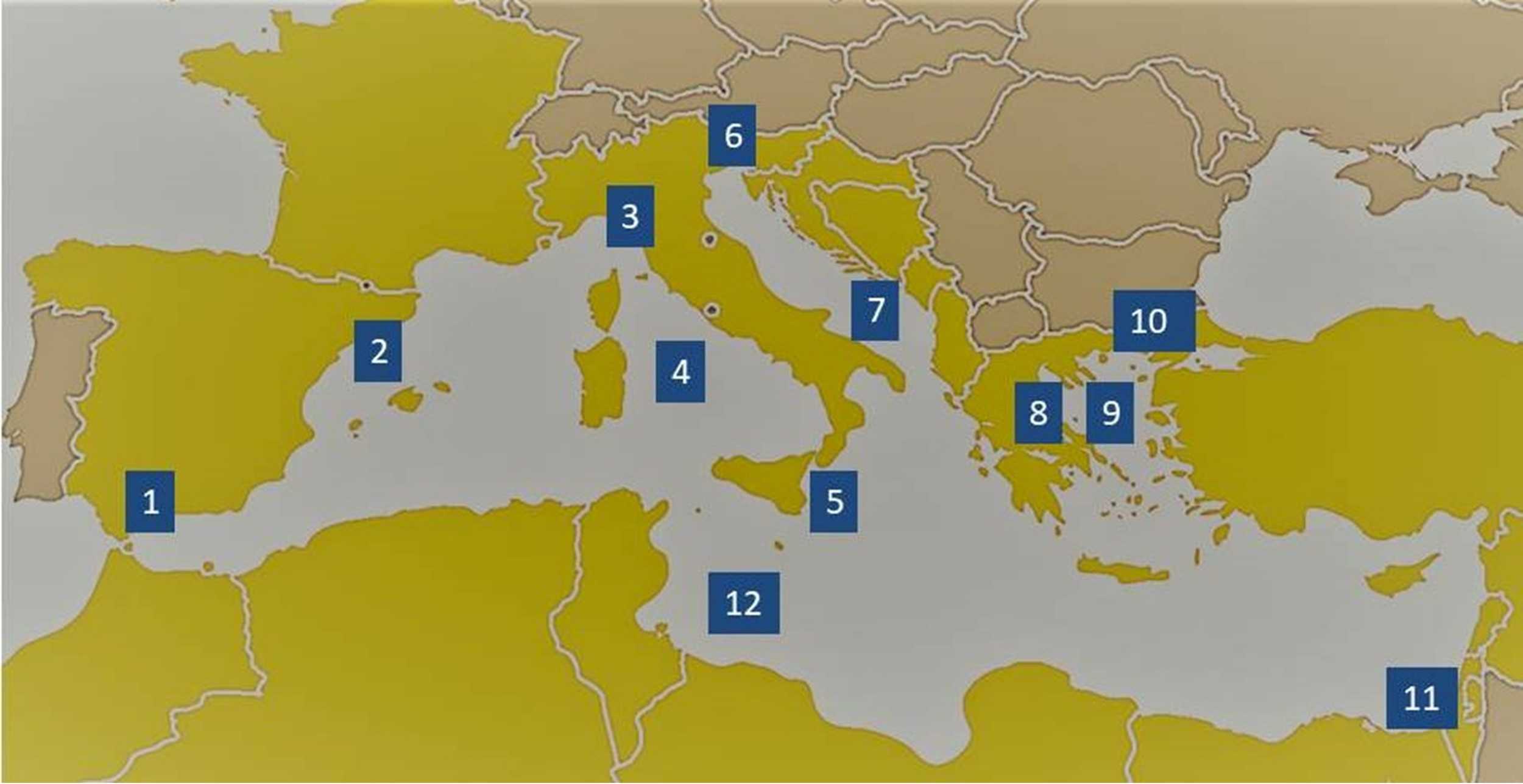
The Mediterranean, arguably the sea enclosed by the cradle of civilisation, is comprised of several smaller seas. Join us on our circumnavigation of the twelve seas as we weave between islands exploring the lesser-known parts of this mighty sea.

A label quiz by Team Phoenix Rising. Estimated time: 3 mins.
  1. Home
  2. »
  3. Quizzes
  4. »
  5. Geography Trivia
  6. »
  7. Bodies of Water
  8. »
  9. Mediterranean Sea

Author
1nn1
Time
3 mins
Type
Label Quiz
Quiz #
410,643
Updated
Oct 26 22
# Qns
12
Difficulty
Easy
Avg Score
10 / 12
Plays
419
Awards
Editor's Choice
Last 3 plays: piperjim1 (12/12), Wordpie (10/12), Mikeytrout44 (12/12).
Sea of Marmara Suez Canal (entrance at Port Said) Gulf of Genoa Tyrrhenian Sea Libyan Sea Gulf of Patra / Gulf of Corinth Strait of Messina Aegean Sea Balearic Sea Adriatic Sea Gulf of Trieste Strait of Gibraltar
* Drag / drop or click on the choices above to move them to the answer list.
1.   
2.   
3.   
4.   
5.   
6.   
7.   
8.   
9.   
10.   
11.   
12.   

Most Recent Scores
Apr 07 2024 : piperjim1: 12/12
Apr 02 2024 : Wordpie: 10/12
Mar 29 2024 : Mikeytrout44: 12/12
Mar 20 2024 : KingLouie6: 12/12
Feb 23 2024 : jackslade: 12/12
Feb 22 2024 : Miroslava1901: 12/12
Feb 21 2024 : Guest 44: 12/12
Feb 21 2024 : Inquizition: 9/12
Feb 21 2024 : Guest 90: 5/12

Quiz Answer Key and Fun Facts
1. Strait of Gibraltar

The western limit of the Mediterranean Sea is two promontories that allow the African and European mainland to be only 13 km / 8 mi apart. On the northern end, this is the Rock of Gibraltar but the promontory which the pillar on the African side lies is unclear. It is either Monte Hacho in Ceuta (Spanish exclave in Africa) or Jebel Musa in Morocco. The narrow band of water between them is the strait of Gibraltar which is 58 km / 36 mi long. The strait opens out eastward to the Alboran Sea, a lesser-known body of water, and at 53000 sq. km, is one of the smaller seas in the Mediterranean. Besides being the location where the saltier Mediterranean Sea empties into the Atlantic Ocean, it has few geographical features save for a few small islands: Isla de Alboran; Islas Chafarinas; Penon de Alhucemas; Penon de Velez de la Gomera, sparsely populated with military personnel and all belonging to Spain.

This question was written by Phoenix Rising Team member 1nn1.
2. Balearic Sea

The Balearic Sea is also known as the Iberian Sea and covers approximately 150,000 square kilometres. It is positioned with Spain to the west, France to the north, and it laps the western coasts of the islands of Corsica and Sardinia. To the northeast is it bordered by the Ligurian Sea. Spain's Ebro River (whose Latin name is the Iberus River, giving the sea its alternate name) drains into the Balearic Sea. It has a relatively subtropical climate with the water's temperature not dropping below 12 deg C (54 deg F) even in winter.

The sea is home to many species of fish, crustaceans, birds and mammals, and to hundreds of varieties of marine flora. The port cities of both Valencia and Barcelona are located on the sea and for centuries, locals have made a living fishing its abundant sea life including bluefin tuna, albacore and swordfish. A popular tourist destination, people flock each year to see the pods of dolphins that play there.

This question was washed up on the shore of the quiz by Phoenix Rising member VegemiteKid.
3. Gulf of Genoa

The Gulf of Genoa is the northernmost part of the Ligurian Sea and is named after the most important port in the region - Genoa. It is bordered by the city of Imperia in the west and the city of La Spezia in the east. The gulf is approximately 145 km (90 mi) wide. The northwest coast of the gulf is renowned for its scenic beauty and favourable climate.

The Ligurian Sea is an arm of the Mediterranean Sea that lies between the Italian Riviera and the French Island of Corsica. The Arno River is the main river that empties into it along with other smaller rivers that originate in the Apennine Mountains. The sea was established as a Specially Protected Areas of Mediterranean Importance (SPAMI) in 1999 to protect its numerous cetacean species. The International Ligurian Sea Cetacean Sanctuary covers about 84,000 square km (32,000 sq mi).

Phoenix Rising member tazman6619 dictated this report from noted cetacean Moby Dick who although he does not come from these waters had vacationed there numerous times.
4. Tyrrhenian Sea

Sailing down the western coast of Italy, the Tyrrhenian Sea has its place in Greek mythology as it is believed that the cliffs above were where the god Aeolus, the god of the winds, stored his four winds... the Mistral, the Libeccio, the Sirocco and the Ostro. That may be a myth but, in actuality, the Tyrrhenian is home to the islands of Corsica, Sardinia, Sicily and Capri, among others.
The sea sits near where the African and Eurasian plates meet and, as a result, it plays house to several mountains and volcanoes, such as Mount Marsili, under its waters. Drawing its name from the Tyrrhenian people, it stretches from the eastern and western extremes of Sicily, across to Sardina and then north to Corsica. If you can picture the boot shape that is Italy, the Tyrrhenian is the football that it is kicking.

In writing this question, Phoenix Rising's pollucci19 stated that he got a little 'emoceanal'.
5. Strait of Messina

The Strait of Messina, which connects the Tyrrhenian Sea with the Ionian Sea also holds a special place in mythology. At the northern end of the strait is a natural whirlpool that, in Greek legend, is linked to the sea monsters Scylla and Charybdis. These two presented a dubious choice, and great risk and challenge to such intrepid voyagers as Ulysses, Jason and Aeneas, and laid the ground for the creation of the idiom "between Scylla and Charybdis".

The strait is only 250 metres deep, can be found in the centre of the Mediterranean Sea and connects Sicily to Europe. It possesses intense tidal activity and a unique biochemical structure that has proven to be a haven for sea floral and fauna. It is also one of the main migration channels for various birds and fish. The strait is a key fishing area and plays host to six different ports: Gioia Tauro, Milazzo, Messina, Villa San Giovanni, Reggio Calabria and Tremestieri. The challenge for the area will continue to be the ability to service the human population whilst protecting the incredible biodiversity of the area.

Despite feeling out of his depth, Phoenix Rising's pollucci19 still managed to surface in time with this question.
6. Gulf of Trieste

Picture the Adriatic Sea between Italy and Greece... then look into the far northern reaches of it. There you will find a shallow bay that is shared by Italy, Slovenia and Croatia. That is the Gulf of Trieste which also contains the entire Slovenian coastline. Its tiny length of 47km (29 mi) includes the port of Koper, Slovenia's only maritime port. On its southern reaches, the Gulf of Piran has been a matter of dispute between Croatia and Slovenia over its sovereignty since 1991 when both nations became independent of Yugoslavia.

Whilst small in size its unique environmental properties, in particular water runoffs/inputs and temperature variations, have made it an area that scientists have put a considerable time on, to get an understanding of phytoplankton blooms and carbon chemistry.

Phoenix Rising's pollucci19 managed to 'seas' the day and put this question together.
7. Adriatic Sea

The Adriatic separates the Italian Peninsula from the Balkan Peninsula. If you picture Italy, the Adriatic covers the back of Italy's boot shape and, on the other side of the sea, you will find the countries of Albania, Bosnia and Herzegovina, Croatia, Montenegro, and Slovenia. Scattered through it are some 1,300 islands, with most of these centred along the Croatian coastline.

There is a high level of endemic sea fauna here as well as a great range of flora. Four of the five Mediterranean seagrasses can be found in the Adriatic. Overall, the biodiversity in this sea is considered to be fairly high and, to assist the maintenance of this, most of the countries that border the sea have created protective zones. The biggest problem for the area though is pollution and the excessive amount of nutrients leeching into its waters. The biggest offender here appears to be Italy, particularly the Po River and Venice.

This question was created by Phoenix Rising's pollucci19 who refused to get himself 'tide' down by it.
8. Gulf of Patra / Gulf of Corinth

If you are sailing south past Albania and need to sail to Athens, you don't have to round the Peloponnese peninsula in the far south of Greece but you can take a shortcut travelling eastward through the Gulf of Patras, then the Gulf of Corinth. However, that was as far east as you could go before the Corinth Canal was dug in 1893 across the Corinth isthmus, effectively making the Peloponnese peninsula an island. The canal has no locks. It is 6 kilometres (4 miles) in length and only 25 metres (80 feet) wide at sea level) making it unsuitable for large ships.

The Gulf of Patras is about halfway down Greece's Ionian coast in the west. The northern boundary is the shore of Aetolia-Acarnania in continental Greece, and in the south by the Peloponnese peninsula. It is 40-50 km (25-30 mi) long, and 10-20 km (6-12. mi) wide. Patras, a major port city, lies in the southeast of the gulf. At its eastern end, it opens out to the larger Gulf of Corinth. It is 130km / 80km long and between 8 - 32km / 5 -20 mi wide, curving to the southeast. The Corinth Canal is in the southeast corner of the gulf. After you traverse the gulf (careful not to bump into the sides) you are now only 65km / 40km from Athens by sea through the Saronic Gulf.

This question was written by Phoenix Rising Team member 1nn1
9. Aegean Sea

The startlingly blue Aegean Sea is situated between the Greek peninsula on the west and Asia Minor to the east. It is a rich and interesting location, and the idea has been 'floated' that it is the source of the legend of the lost island of Atlantis. There are some 1400 small islands to be found in the 215,000 square km (83,000 square miles) in area that makes up the sea. The floor of the Aegean, at some 3,545m (11,630ft) below sea level, is mostly limestone. Because of the local volcanic activity, some islands in the area such as Thera and Melos have splendidly coloured sediment.

The Aegean is subdivided into the Myrtoan Sea and the Thracian Sea and is a prolific source of fish - indeed, Greece has the second-largest fishing fleet in Europe; this is partly due to the surface temperature of the Aegean, which ranges from 16 to 25 °C (60 to 77 °F), depending on the time of year. As the cradle of Western civilisation, it is also a major tourist destination.

Phoenix Rising teammate VegemiteKid jumped on a raft and sailed into the sea to see what there was to see.
10. Sea of Marmara

The Sea of Marmara is a small sea surrounded by Turkey. It connects the Aegean Sea with the Black Sea through the narrow Turkish straits: The Dardanelles in the southwest and the Bosporus in the northeast.

If you are sailing from the Aegean you will need to be careful in locating it as the Dardanelles are very narrow - from 1.2 to 6 kilometres wide and 61 kilometres long with Canakkale being a major Turkish city on the east bank. The west bank is the Gallipoli peninsula, a narrow mountainous region, sparsely populated and well-known as the place where the ANZAC legend started.

The Sea of Marmara is 280km across and an average of 80km across. The sea is named for the second largest island in the sea, Marmara being known for its marble, which features prominently in Turkish architecture. There are over a dozen inhabited islands in the sea and a few more uninhabited ones.

The Bosporus is a narrow strait 31km long and a maximum of 700 metres wide. It separates Asia from Europe (Anatolia in Asia and Thrace in Europe. It also splits Istanbul in two). The maritime route from the Aegean Sea to the Black Sea is a major world transport route to Ukraine and Russian ports. The Bosporus is the world's narrowest strait used for international navigation.

This question was written by Phoenix Rising Team member 1nn1.
11. Suez Canal (entrance at Port Said)

In Egypt, Port Said and its counterpart Port Fuad on the Suez Canal east bank form a metropolis of over one million people. Neither existed before 1859 when Mohamed Said (ruler of Egypt), granted Frenchmen Ferdinand de Lesseps the concession rights to dig the Suez Canal.

It was a wasteland with nil resources, natural or otherwise. Everything Port Said needed had to be imported: wood, stone, equipment, housing, labour, food and water. Giant water tanks were erected to supply fresh water until the Sweet Water Canal could be completed. One of the most pressing problems was the lack of stone. Early buildings were often imported in kit form. The canal was completed in ten years with indentured labour. Over 120 000 people worked on the project with one to three thousand dying (mainly from cholera).

The canal is 193 km long and a minimum of 205 metres wide. It connects Port Said with the Red Sea port of Suez. If sailing around the Mediterranean, apart from the heavy shipping migrating to its entrance, the canal is marked with two breakwaters, the western one reaching 6km into the Mediterranean Sea.

The Suez Canal entrance is part of the Levantine Sea which is bordered by Turkey in the north and Syria, Lebanon, Israel, and Palestine in the east. Egypt is the southern boundary. As its western border is poorly defined, the name "Mediterranean Sea" is more commonly used for this maritime area.

This question was written by Phoenix Rising Team member 1nn1.
12. Libyan Sea

Heading west now, the Libyan Sea is that part of the Mediterranean that lies off the North coast of Africa. The north edge of the sea is bordered by Crete and the Ionian Sea, while the Levantine Sea lies to the east, and the Strait of Sicily to the west.

The Barbary Coast was a name given to the North African coast that lies along the Libyan Sea, during the 16th to 19th centuries. It was an exonym that was given to the region because of the Berbers who lived in the area. It specifically focused on the coast that was controlled by the Ottoman Empire during this time. There were Barbary States that occupied the area and it was a great source of piracy during these centuries. One of the main rulers during this time was the Pasha of Tripoli. Others included the Dey of Algiers, the Bey of Tunis, and the Sultan of Morocco.

In an interesting aside, the Barbary Coast played a significant role in US history as the pirates from the region were the first confronted by the newly formed US Navy and Marine Corps at the beginning of the 1800s. It was their acts of piracy that forced the US to have to develop a navy to confront them. The Marine Corps hymn begins with the words, "From the Halls of Montezuma to the Shores of Tripoli..." in recognition of the First and Second Barbary Wars.

This question was pirated from another source and then dropped into the quiz by Phoenix Rising member tazman6619.
Source: Author 1nn1

This quiz was reviewed by FunTrivia editor agony before going online.
Any errors found in FunTrivia content are routinely corrected through our feedback system.
4/19/2024, Copyright 2024 FunTrivia, Inc. - Report an Error / Contact Us