FREE! Click here to Join FunTrivia. Thousands of games, quizzes, and lots more!
Quiz about Journey Through Peru

Journey Through Peru Trivia Quiz


The country of Peru is full of many beautiful and historic sites. From gorgeous landscapes to sites recognized across the globe, Peru has something for everyone who enjoys exploring something new. Take a trip with me through this amazing country! C'mon!

A photo quiz by jddrsi_raven. Estimated time: 4 mins.
  1. Home
  2. »
  3. Quizzes
  4. »
  5. Geography Trivia
  6. »
  7. South America
  8. »
  9. Peru

Author
jddrsi_raven
Time
4 mins
Type
Photo Quiz
Quiz #
423,513
Updated
Nov 16 26
# Qns
10
Difficulty
New Game
Avg Score
8 / 10
Plays
8
Last 3 plays: bernie73 (7/10), 7Kat7 (9/10), Guest 198 (8/10).
-
Question 1 of 10
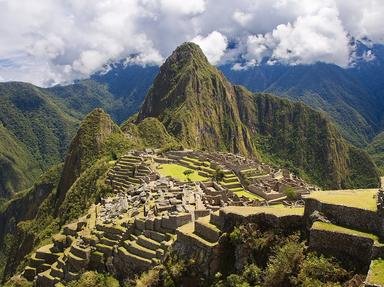
1. Our first stop on our journey leads us to the Urubamba Province. Built during the Inca Empire, this structure is often referred to as the "lost city." It was named a UNESCO World Heritage Site in 1983. It is arguably the most famous landmark within Peru. Name it. Hint


Question 2 of 10
2. Heading out, we reach the nearest city from our starting point. Near the Sacred Valley in the Andes Mountains, this city is considered the Historical capital of Peru, and is a UNESCO world heritage site. Name this city? Hint


Question 3 of 10
3. This lake is the largest lake in South America, and covers land in Peru and in neighboring Bolivia. It is also the highest lake by elevation in the world. Name this lake. Hint


Question 4 of 10
4. Nestled between three volcanoes, this Peruvian city is famed for its colonial architecture from volcanic stone. Since the stone that many buildings are built with is white, it is known as "The White City." Name this city. Hint


Question 5 of 10
5. North of Lima, this city is located in the Andes Mountains, close to the tallest mountain peak in the country. It is a popular location for people to begin high altitude treks through the Andes. Can you name this city? Hint


Question 6 of 10
6. We would be remiss if we didn't pay a visit to the capital city of Peru. Like many capital cities, Lima is its country's largest city, home to over ten million people. It was chosen as the capital city over the Inca capital of Cusco. Why was Lima chosen as the capital?


Question 7 of 10
7. Our next city is home to the famous "lines," which are a series of geoglyphs etched into the ground. It also hosts underground aqueducts built by the ancient civilization in the city that are still in use!


Question 8 of 10
8. Our next stop is another famous landmark in Peru. Colca Canyon is a 43 mile canyon that was created over time by the Colca River in the Arequipa Region of Peru.

True or false: the Colca Canyon is deeper than the Grand Canyon in Arizona.


Question 9 of 10
9. Our next stop in Peru is known for being a desert oasis in the southwestern part of the country. Surrounded by sand dunes, this village receives thousands of visitors every year. Name the place. Hint


Question 10 of 10
10. Our final stop on this Peruvian tour is the city of Iquitos. It is the largest city in the world that cannot be accessed by road. It can only be reached by air or river. As such, it is considered the main way to reach what famous river system and rainforest in that region?

Answer: (One word! Don't overthink it!)

(Optional) Create a Free FunTrivia ID to save the points you are about to earn:

arrow Select a User ID:
arrow Choose a Password:
arrow Your Email:


View Image Attributions for This Quiz

Most Recent Scores
Today : bernie73: 7/10
Today : 7Kat7: 9/10
Today : Guest 198: 8/10
Today : Rizeeve: 10/10
Today : ZWOZZE: 10/10
Today : PurpleComet: 5/10
Today : xchasbox: 9/10

Quiz Answer Key and Fun Facts
1. Our first stop on our journey leads us to the Urubamba Province. Built during the Inca Empire, this structure is often referred to as the "lost city." It was named a UNESCO World Heritage Site in 1983. It is arguably the most famous landmark within Peru. Name it.

Answer: Machu Picchu

Machu Picchu was built in the 1400s by the Inca Empire. It served as the royal estate and a religious sanctuary. During the Spanish conquest, it was abandoned, and therefore remained undiscovered. American explorer Hiram Bingham rediscovered it in 1911, and it was declared a Peruvian historical site in 1981.

It is considered one of the New Seven Wonders of the world, earning that honorific in 2007.
2. Heading out, we reach the nearest city from our starting point. Near the Sacred Valley in the Andes Mountains, this city is considered the Historical capital of Peru, and is a UNESCO world heritage site. Name this city?

Answer: Cusco

Cusco was named a UNESCO World Heritage Site in 1983, alongside Machu Picchu. It was considered the capital of the Inca Empire, and is still considered the historical capital of the country. Cusco is also home to the "Temple of the Sun"; Qorikancha, was the religious center of the Inca Empire. Given its proximity to Machu Picchu, those that wish to visit use Cusco as the place to begin their journey.
3. This lake is the largest lake in South America, and covers land in Peru and in neighboring Bolivia. It is also the highest lake by elevation in the world. Name this lake.

Answer: Lake Titicaca

The drawing for this picture is a rough sketch of the lake, which is home to the native Uros people. They build floating islands, like the one in the drawing, out of local flora. Lake Titicaca is divided into the northern and southern regions. The northern basin is larger, and is connected to the smaller basin by the Strait of Tiquina, located in Bolivia.
4. Nestled between three volcanoes, this Peruvian city is famed for its colonial architecture from volcanic stone. Since the stone that many buildings are built with is white, it is known as "The White City." Name this city.

Answer: Arequipa

Arequipa is the second most populous city in Peru, and sits at an elevation of over 7,500 feet. The three volcanoes that are the backdrop to many snapshots of the city are El Misti, Chachani and Pichu Pichu. The stone that has built many of Arequipa's buildings is made from white volcanic stone called sillar.

This was formed from volcanic activity and then harvested from quarries by the local people to build many of the older buildings in the city.
5. North of Lima, this city is located in the Andes Mountains, close to the tallest mountain peak in the country. It is a popular location for people to begin high altitude treks through the Andes. Can you name this city?

Answer: Huaraz

Huaraz is located in the Callejon de Huaylas valley in the Andes. Because it is located at an elevation of over 10,000 feet, it is a popular location for high altitude hikes and climbing. Many people travel to hike in the high altitude to prepare for hiking even higher altitudes, like the Himalayan Mountains.

The highest peak in Peru is Huascaran, whose height towers over Huaraz at over 22,000 feet above sea level.
6. We would be remiss if we didn't pay a visit to the capital city of Peru. Like many capital cities, Lima is its country's largest city, home to over ten million people. It was chosen as the capital city over the Inca capital of Cusco. Why was Lima chosen as the capital?

Answer: Its coastal location made communication with Spain easier

Founded by Spanish conqueror Francisco Pizarro in 1535, Lima was originally known as the "City of Kings." Lima is considered the culinary capital of South America, with plenty of access to fresh seafood from the Pacific Ocean that lies below its cliffs.

Many of the incoming flights from other countries land in Lima first, as it is the main hub for much of the air traffic to other parts of Peru.
7. Our next city is home to the famous "lines," which are a series of geoglyphs etched into the ground. It also hosts underground aqueducts built by the ancient civilization in the city that are still in use!

Answer: Nazca

The Nazca Lines are geoglyphs created by the Nazca culture centuries ago. There's some uncertainty as to just how much of the Peruvian landscape that the Nazca Lines span. The general consensus is anywhere between 400 and 1,000 square kilometers. There are a combination of straight lines and trapezoid shapes created by the lines, many of which form shapes of animals and human-like figures.

The Nazca Lines were designated a UNESCO World Heritage Site in 1994.
8. Our next stop is another famous landmark in Peru. Colca Canyon is a 43 mile canyon that was created over time by the Colca River in the Arequipa Region of Peru. True or false: the Colca Canyon is deeper than the Grand Canyon in Arizona.

Answer: True

Wending its way through the Andes Mountains, the Colca River carved its way through what is now the Colca Canyon. The canyon is one of the deepest canyons in the world at nearly 11,000 feet in depth. Near the midpoint of the valley is the town of Chivay, a popular location for tourists visiting the local thermal springs or Cruz Del Condor, a spot where people can view the local Andean condor.
9. Our next stop in Peru is known for being a desert oasis in the southwestern part of the country. Surrounded by sand dunes, this village receives thousands of visitors every year. Name the place.

Answer: Huacachina

Located south of Lima and surrounded by towering sand dunes, the village of Huacachina is a popular tourist destination for thousands every year. Dune buggy riding, dune hiking and sand boarding are all popular pastimes for those that visit this desert oasis. Huacachina was even commemorated in Peruvian currency.

It was depicted on the 50 sol note at one point in time; however, those notes are no longer in circulation.
10. Our final stop on this Peruvian tour is the city of Iquitos. It is the largest city in the world that cannot be accessed by road. It can only be reached by air or river. As such, it is considered the main way to reach what famous river system and rainforest in that region?

Answer: Amazon

Iquitos is the largest city in the Peruvian Amazon, and the largest city in the world inaccessible by roadway. Cruises along the Amazon River and rainforest treks in the northern region typically begin in Iquitos. It became a thriving city due in large part to its natural production of rubber.

There is also a wildlife reserve, which is a popular visiting spot for those that love to observe nature.
Source: Author jddrsi_raven

This quiz was reviewed by FunTrivia editor agony before going online.
Any errors found in FunTrivia content are routinely corrected through our feedback system.
Related Quizzes
1. A Whirlwind Tour of Peru Average
2. 9 for 10 - Peru Average
3. The Salkantay Trek Average
4. Peru Average
5. All Aboard! Average
6. Perplexing Peru Average
7. Perú, The Incas Country Tough
8. The Monster Inside Very Easy
9. South America Match-Up Very Easy
10. Mapping South America Easier
11. South American Countries by Size Easier
12. South and Central America Easier

11/16/2026, Copyright 2026 FunTrivia, Inc. - Report an Error / Contact Us