FREE! Click here to Join FunTrivia. Thousands of games, quizzes, and lots more!
Quiz about The Salkantay Trek

The Salkantay Trek Trivia Quiz

Cusco to Machu Picchu

Discover the natural wonders, Indigenous traditions, and Inca history encountered along the Salkantay Trek, one of Peru's most spectacular routes to Machu Picchu. While variations of the trek exist, this quiz follows a classic five-day itinerary.

A photo quiz by reedy. Estimated time: 3 mins.
  1. Home
  2. »
  3. Quizzes
  4. »
  5. Geography Trivia
  6. »
  7. South America
  8. »
  9. Peru

Author
reedy
Time
3 mins
Type
Photo Quiz
Quiz #
424,924
Updated
Jul 25 26
# Qns
10
Difficulty
New Game
Plays
7
Last 3 plays: Guest 77 (4/10), xchasbox (3/10), Guest 24 (3/10).
-
Question 1 of 10
1. (Day 1) Near the Salkantay Trek trailhead at Challacancha, hikers encounter stone water channels dug into the terrain. These are remnants of irrigation systems constructed by the Inca.


Question 2 of 10
2. (Day 1) According to local folklore, which Andean goddess is said to reside in the waters of Humantay Lake? Hint


Question 3 of 10
3. (Day 2) Salkantay Mountain - the namesake of the trek - is known in Quechua as "Sallqa Antay." What is the most common - and daunting - English translation of this name? Hint


Question 4 of 10
4. (Day 2) Scattered throughout the Salkantay Pass (and in other places along the trek) are stacked stone cairns, placed as a form of tribute to the mountains and spirits of the land. What is the term for these offerings, derived from the Quechua and Aymara languages? Hint


Question 5 of 10
5. (Day 3) The beautiful Coripacchi Waterfalls are encountered as hikers descend from the heights of the Salkantay Pass. Translated from the Quechua language, what is the lustrous English name of this feature? Hint


Question 6 of 10
6. (Day 3) The Cocalmayo Hot Springs are a popular stop on the Salkantay Trek. Near which town, named for a sixteenth-century Spanish mystic later declared a Doctor of the Church, are they found? Hint


Question 7 of 10
7. (Day 4) Near the next waypoint on the trek, a dramatic waterfall-like cascade plunges down the mountainside before joining the Urubamba River. What is the source of this water? Hint


Question 8 of 10
8. (Day 4) The railway-side walk from Hidroelectrica leads to a town that can only be reached by train or on foot. What is the name of this gateway to Machu Picchu? Hint


Question 9 of 10
9. (Day 5) As the final climb toward Machu Picchu joins the ancient Inca Trail, hikers reach Inti Punku. By what English name is this historic gateway to the citadel better known? Hint


Question 10 of 10
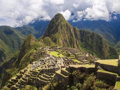
10. (Day 5) For many trekkers, the first sight of Machu Picchu comes from Inti Punku after days of hiking through the Andes. Although local residents had always known of its existence, which American explorer brought Machu Picchu to international attention in 1911? Hint


(Optional) Create a Free FunTrivia ID to save the points you are about to earn:

arrow Select a User ID:
arrow Choose a Password:
arrow Your Email:


View Image Attributions for This Quiz

Most Recent Scores
Today : Guest 77: 4/10
Today : xchasbox: 3/10
Today : Guest 24: 3/10
Today : hosertodd: 10/10
Today : bernie73: 3/10
Today : BadCelery: 8/10
Today : misdiaslocos: 9/10

Quiz Answer Key and Fun Facts
1. (Day 1) Near the Salkantay Trek trailhead at Challacancha, hikers encounter stone water channels dug into the terrain. These are remnants of irrigation systems constructed by the Inca.

Answer: True

Day 1 of the Classic Salkantay Trek begins well before the hiking starts. To reach the starting point, adventurers must depart early from Cusco for a drive of about three hours into the Andes, usually with a breakfast stop in Mollepata before continuing to the trailhead at Challacancha (elevation 3,680 m (12,073 ft)).

Once on the trail, the walk to Soraypampa is a gentle introduction to the trek, giving hikers time to settle into the rhythm of walking at altitude and opportunities to take in the scenery. The path follows a broad mountain valley, with streams, grazing animals, and the snow-covered peaks of Humantay and Salkantay gradually coming into view. Along the way, the trail passes old Inca irrigation channels, still tracing their way across the landscape centuries after they were built. Many segments have been maintained and remain in use today.
2. (Day 1) According to local folklore, which Andean goddess is said to reside in the waters of Humantay Lake?

Answer: Pachamama (Mother Earth)

Depending on how the morning went and when trekkers arrive at the Soraypampa campsite, an optional afternoon hike to Humantay Lake is an enticement, and for many trekkers it becomes the highlight of the first day. From Soraypampa, the trail climbs steadily toward the basin below Humantay Mountain, and while the ascent can feel challenging in the thin air, each switchback reveals wider views of the surrounding peaks and valleys.

At the top, the lake appears beneath the glacier-fed slopes of Humantay at an elevation of 4,200 m (13,780 ft), its water a striking shade of turquoise that contrasts with the grey rock and white snow above. The colour comes from glacial minerals suspended in the water, and on a calm day the lake reflects the surrounding mountains like a mirror.

Many visitors choose to pay tribute to Pachamama, or Mother Earth, while visiting Humantay Lake. A traditional offering consists of coca leaves, which are presented as a gesture of gratitude and respect for the mountains, water, and land. In keeping with Andean beliefs of reciprocity with nature, the offering symbolizes giving thanks for the blessings and protection provided by the sacred landscape surrounding the lake.

After their visit, hikers retrace their route to Soraypampa to spend the night and prepare for Day 2.
3. (Day 2) Salkantay Mountain - the namesake of the trek - is known in Quechua as "Sallqa Antay." What is the most common - and daunting - English translation of this name?

Answer: Savage Mountain

Day 2 is dominated by the mountain that gives the trek its name: Salkantay. Derived from the Quechua words sallqa ("wild" or "untamed") and antay ("highland" or "mountain region"), its name is commonly translated as "Savage Mountain" or "Wild Mountain." The name reflects both the peak's imposing presence and the powerful mountain spirit, or apu, it is believed to embody in Andean tradition.

The day begins before sunrise at Soraypampa, where hikers leave camp and start the long climb toward Salkantay Pass. The trail steadily gains elevation through a stark alpine landscape of rock, grass, and glacial streams. Depending on the pace of the group, the ascent from Soraypampa to the pass typically takes about three hours.

As the trail climbs higher, vegetation becomes scarce and the views become increasingly dramatic. The final approach to the pass is often the toughest section of the trek, with the thin air making every uphill step feel a little harder than the last. Reaching Salkantay Pass, at an elevation of 4,630 m (15,190 ft), is one of the defining moments of the journey.
4. (Day 2) Scattered throughout the Salkantay Pass (and in other places along the trek) are stacked stone cairns, placed as a form of tribute to the mountains and spirits of the land. What is the term for these offerings, derived from the Quechua and Aymara languages?

Answer: Apachetas

As already noted, crossing Salkantay Pass is one of the most memorable moments of the trek. At the summit, the trail passes through a field of stone cairns - apachetas - small stacks of rocks left by hikers and local people over many years. The term apacheta comes from the Quechua and Aymara languages and is generally understood to mean a pile of stones or a marker at a mountain pass or point of transit. Over centuries, some apachetas have grown into large monuments, each stone representing the prayers, gratitude, or intentions of countless travelers.

After taking in the views and catching a breath in the thin mountain air, the route begins its long descent from the pass. The change in scenery is gradual but unmistakable. The barren slopes and glacial terrain give way to greener hillsides, and small streams and waterfalls appear alongside the trail. By the time hikers reach Huayracmachay for a rest and lunch stop, the mountains already feel less severe and the air a little warmer.

The afternoon continues downhill through valleys carved by meltwater flowing from the high peaks. With every hour, more vegetation appears, marking the transition from the high Andes toward the cloud forest. Eventually the trail reaches Chaullay (elevation 2,900 m / 9,514 ft), where the second night is spent. Set among greener slopes and a noticeably milder climate, the campsite provides a welcome contrast to the cold, windswept heights crossed earlier in the day.
5. (Day 3) The beautiful Coripacchi Waterfalls are encountered as hikers descend from the heights of the Salkantay Pass. Translated from the Quechua language, what is the lustrous English name of this feature?

Answer: Golden Waterfall

Leaving Chaullay behind, the route continues into the cloud forest, where warmer temperatures and increasingly tropical surroundings provide a sharp contrast to the high Andes crossed the previous day. Covering approximately 16 km (10 mi), this section is considerably easier than the ascent to Salkantay Pass, with most of the journey following a gradual downhill slope.

The trail follows the river through lush greenery, passing waterfalls, small farms, and patches of tropical forest. Along the way, hikers encounter the impressive Coripacchi Falls. Derived from the Quechua words quri (gold) and paqcha (waterfall), the name translates as "Golden Waterfall." The falls cascade down the valley wall in a series of streams fed by rainfall and runoff from the surrounding mountains.
6. (Day 3) The Cocalmayo Hot Springs are a popular stop on the Salkantay Trek. Near which town, named for a sixteenth-century Spanish mystic later declared a Doctor of the Church, are they found?

Answer: Santa Teresa

The hiking portion of Day 3 ends near Playa Sahuayaco (La Playa). From there, many trekking itineraries include a vehicle transfer to Santa Teresa rather than continuing entirely on foot. Near Santa Teresa, hikers can relax at the Cocalmayo Hot Springs, located at an elevation of approximately 1,450 m (4,757 ft). Set beside the river and surrounded by steep green hillsides, the naturally heated pools offer a welcome opportunity to soak tired muscles after three days on the trail. The warmer climate and lush surroundings provide a striking contrast to the glaciers and alpine camps encountered earlier in the trek.

The town of Santa Teresa takes its name from Saint Teresa of Ávila, the sixteenth-century Spanish mystic and Carmelite nun who became one of the most influential figures in Christian history. Originally founded as Santa Teresa de Huadquiña, the settlement retained the saint's name as it grew into an important community along the route to Machu Picchu.
7. (Day 4) Near the next waypoint on the trek, a dramatic waterfall-like cascade plunges down the mountainside before joining the Urubamba River. What is the source of this water?

Answer: Water discharged from a hydroelectric facility

After a night near Santa Teresa, the route turns toward Hidroelectrica, the railway station that marks the beginning of the trek's final stage. The trail follows the Urubamba Valley through a warm subtropical landscape, passing farms, forested slopes, and the river that has accompanied much of the journey.

By this stage of the trek, the long descent from the high Andes has largely come to an end. Rather than continuing downward, the route gradually follows the valley back uphill, marking the beginning of the final leg of the journey toward Machu Picchu.

As hikers near Hidroelectrica, they can see water discharged from the nearby hydroelectric facility plunging down the mountainside in a broad, waterfall-like cascade before joining the Urubamba River below. Although man-made rather than a natural waterfall, its size and volume make it one of the more distinctive sights along this section of the trek.
8. (Day 4) The railway-side walk from Hidroelectrica leads to a town that can only be reached by train or on foot. What is the name of this gateway to Machu Picchu?

Answer: Aguas Calientes

From Hidroelectrica, the final hiking segment of Day 4 follows the railway line toward Aguas Calientes, the town at the base of Machu Picchu. The walk takes about two to three hours and is one of the easiest sections of the trek.

For much of the route, the tracks run alongside the Urubamba River, winding through a narrow, forested valley beneath steep mountainsides. The river remains a constant presence, while dense vegetation and the occasional passing train reinforce the sense that Machu Picchu is drawing ever closer.

As the trail follows the railway deeper into the valley, the first buildings of Aguas Calientes eventually come into view. The town's name, which translates from Spanish as "Hot Waters," refers to the thermal springs found nearby. Reaching Aguas Calientes brings Day 4 to a close and provides a final opportunity to rest before the ascent to Machu Picchu on the morning of Day 5.
9. (Day 5) As the final climb toward Machu Picchu joins the ancient Inca Trail, hikers reach Inti Punku. By what English name is this historic gateway to the citadel better known?

Answer: Sun Gate

Day 5 begins before sunrise in Aguas Calientes, where the trail climbs steeply out of the valley toward Machu Picchu. Stone steps wind through the cloud forest, steadily gaining elevation as the Urubamba River drops farther below. Here, the Salkantay and Inca trails converge for their final approach to the ancient city.

As the path rises, it eventually joins the route leading to Inti Punku. Perched high above the citadel, this historic gateway likely served both ceremonial and practical functions. Its alignment with the rising sun has led archaeologists to associate it with Inca solar observations and the worship of Inti, the sun god, underscoring the sacred significance of the approach to Machu Picchu.
10. (Day 5) For many trekkers, the first sight of Machu Picchu comes from Inti Punku after days of hiking through the Andes. Although local residents had always known of its existence, which American explorer brought Machu Picchu to international attention in 1911?

Answer: Hiram Bingham

From the Sun Gate, hikers are rewarded with one of the most iconic views of Machu Picchu, with the citadel spread out below amid the surrounding Andean peaks. For those arriving on foot, it is a fitting culmination to the journey, offering a perspective that few visitors who arrive by train or bus experience.

Built during the height of the Inca Empire in the fifteenth century, most likely during the reign of the emperor Pachacuti, Machu Picchu occupies a mountain ridge high above the Urubamba River. It is believed to have served as a royal estate, ceremonial center, or a combination of both. The city was carefully integrated into the surrounding landscape, with temples, terraces, fountains, and residences connected by an intricate network of stone pathways.

Following the Spanish conquest of the Inca Empire in the sixteenth century, the site appears to have been abandoned. Because it remained largely unknown to the outside world, it escaped the destruction that befell many other Inca settlements. In 1911, while searching for the lost Inca capital of Vilcabamba, American explorer Hiram Bingham was led to the overgrown ruins of Machu Picchu by local residents. Although he had not found the city he was seeking, his expeditions helped bring international attention to the site and sparked decades of archaeological study.

Machu Picchu was designated a UNESCO World Heritage Site in 1983 and is recognized as one of the world's most important archaeological treasures. Its remarkable preservation, dramatic setting, and enduring connection to Inca culture continue to draw visitors from around the globe.
Source: Author reedy

This quiz was reviewed by FunTrivia editor agony before going online.
Any errors found in FunTrivia content are routinely corrected through our feedback system.
7/25/2026, Copyright 2026 FunTrivia, Inc. - Report an Error / Contact Us