FREE! Click here to Join FunTrivia. Thousands of games, quizzes, and lots more!
Quiz about Locating Madagascar

Locating Madagascar Trivia Quiz


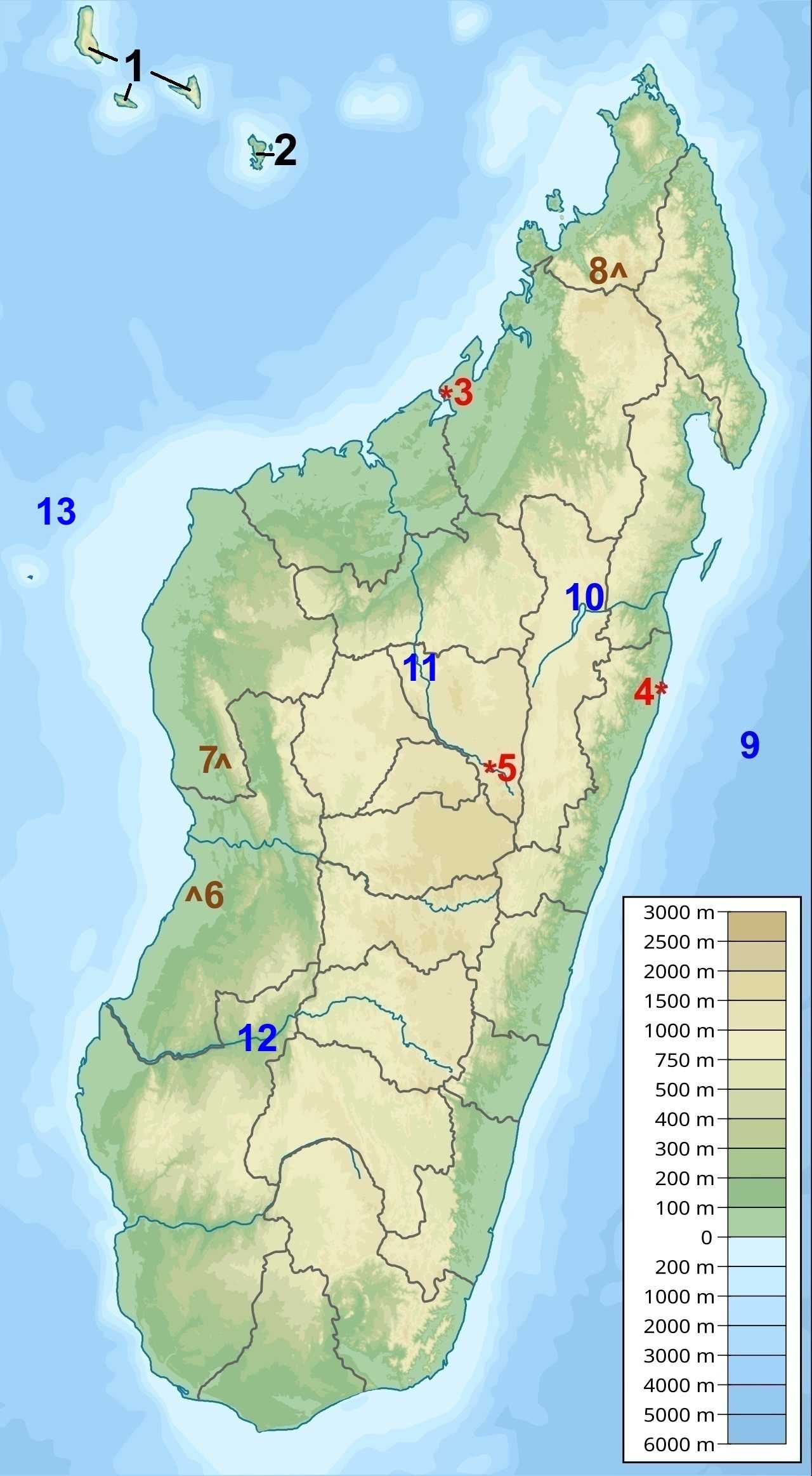
Madagascar is the world's fourth-largest island and is renowned for its unique wildlife, found nowhere else on Earth. Can you locate some of its major cities, landforms, waterways, and neighbouring islands?

A label quiz by reedy. Estimated time: 3 mins.
  1. Home
  2. »
  3. Quizzes
  4. »
  5. Geography Trivia
  6. »
  7. Africa
  8. »
  9. Madagascar

Author
reedy
Time
3 mins
Type
Label Quiz
Quiz #
425,779
Updated
Oct 04 26
# Qns
13
Difficulty
New Game
Plays
4
Last 3 plays: bernie73 (7/13), Guest 98 (13/13), Upstart3 (13/13).
Click on image to zoom
Lake Alaotra Avenue of the Baobabs Antananarivo (Tana) Toamasina (Tamatave) Ikopa River Tsingy de Bemaraha Mahajanga (Majunga) Indian Ocean Mangoky River Comoros Maromokotro Mayotte Mozambique Channel
* Drag / drop or click on the choices above to move them to the answer list.
View Image Attributions for This Quiz
1. The Perfume Islands  
2. French overseas department  
3. City of Flowers  
4. Port aux prunes  
5. Capital city  
6. Protected Natural Monument  
7. UNESCO World Heritage Site  
8. Highest point  
9.   
10.   
11. Tributary of the Betsiboka River  
12. Longest river  
13.   

Most Recent Scores
Today : bernie73: 7/13
Today : Guest 98: 13/13
Today : Upstart3: 13/13
Today : skatersarehott: 1/13

Quiz Answer Key and Fun Facts
1. Comoros

The Comoros is an island nation located northwest of Madagascar, near the northern end of the Mozambique Channel. The country consists of three main islands: Grande Comore, Mohéli, and Anjouan. The islands are sometimes called the "Perfume Islands" because of their long history of producing fragrant crops such as ylang-ylang, vanilla, cloves, and other spices for export.

The islands are volcanic in origin, and Mount Karthala on Grande Comore is one of the world's most active volcanoes. The Comoros gained independence from France in 1975, though political instability has led to dozens of coups and coup attempts since then.

Comoros is one of the few countries in the world that belongs simultaneously to the African Union, Arab League, Organisation of Islamic Cooperation, and Francophonie.
2. Mayotte

Mayotte is a French overseas department located between Madagascar and Mozambique at the northern entrance to the Mozambique Channel. Although geographically part of the Comoro Islands, the people of Mayotte voted several times to remain French rather than join the independent Comoros.

As an overseas department, Mayotte is considered an integral part of France and the European Union. The island uses the Euro as its currency and sends representatives to the French Parliament in Paris.

Mayotte is surrounded by one of the world's largest enclosed lagoons, protected by a barrier reef stretching more than 150 km (93 mi).
3. Mahajanga (Majunga)

Mahajanga is Madagascar's largest city on the western coast and serves as an important port on Bombetoka Bay. The city lies near the mouth of the Betsiboka River, whose distinctive red sediment can often be seen from space flowing into the sea.

The city developed as a major trading center due to its sheltered harbour and strategic location along Indian Ocean trade routes linking East Africa, Arabia, and Asia. Traces of Arab, African, Indian, and European influences can still be found throughout the city.

Mahajanga is often known as the "City of Flowers" because of its tropical vegetation, colourful gardens, and warm year-round climate. It is also known for its waterfront promenade and giant baobab trees.
4. Toamasina (Tamatave)

Toamasina is Madagascar's principal seaport and second-largest city, located on the country's east coast facing the Indian Ocean. Nearly all of Madagascar's international maritime trade passes through its harbour.

The city began as a modest fishing village before becoming an important colonial port under French rule. Its French nickname, "Port aux prunes" ("Port of Plums"), refers to the fruit and other agricultural products that were historically shipped through its harbour. Today it remains the country's primary gateway for imported goods and exported products such as vanilla, cloves, coffee, and lychees.

Because of its location on the cyclone-prone eastern coast, Toamasina has experienced significant storm damage throughout its history, including major impacts from several powerful tropical cyclones.
5. Antananarivo (Tana)

Antananarivo is the capital and largest city of Madagascar, occupying a series of steep hills in the country's central highlands at an elevation of approximately 1,280 m (4,200 ft). The city is often abbreviated to "Tana."

The city was established in the early 17th century as the capital of the Merina Kingdom. Its name means "City of the Thousand," referring to the soldiers reportedly assigned to guard the settlement by King Andrianjaka.

Antananarivo serves as Madagascar's political, economic, and cultural center. Historic royal palaces, churches, markets, and colonial-era buildings overlook the surrounding rice paddies that fill the valleys below.
6. Avenue of the Baobabs

The Avenue of the Baobabs is one of Madagascar's most recognizable natural landmarks. Located near Morondava on the island's western coast, the avenue features a remarkable concentration of towering Grandidier's baobab trees.

Many of the trees are estimated to be between 800 and 1,000 years old, reaching heights of more than 30 m (100 ft). These giants are survivors of a forest ecosystem that largely disappeared as surrounding land was cleared for agriculture.

Recognizing its ecological and cultural significance, the Malagasy government granted the Avenue of the Baobabs temporary protected status in 2007. In 2015, the site was officially designated a Natural Monument, helping to ensure the preservation of these iconic trees and the surrounding landscape for future generations.

The site has become one of Madagascar's most visited tourist attractions, particularly at sunrise and sunset when the towering trees create dramatic silhouettes against the sky.
7. Tsingy de Bemaraha

Tsingy de Bemaraha is a UNESCO World Heritage Site located in western Madagascar. The reserve is famous for its extraordinary limestone formations known as tsingy, a Malagasy word meaning "where one cannot walk barefoot."

Over millions of years, water eroded the limestone plateau into a maze of razor-sharp pinnacles, deep canyons, caves, and sinkholes. Some of the formations rise more than 100 m (328 ft) above the surrounding landscape.

The reserve protects numerous endemic species, including several forms of lemurs, birds, reptiles, and plants found nowhere else on Earth.
8. Maromokotro

Maromokotro is Madagascar's highest mountain, rising to an elevation of 2,876 m (9,436 ft). It is located in the Tsaratanana Massif in the island's far north.

Although Madagascar is often associated with tropical climates, temperatures at the summit can occasionally drop near freezing during the cooler months, and frost is not uncommon at higher elevations.

The mountain lies within the Tsaratanana Strict Nature Reserve, one of Madagascar's most remote protected areas. The reserve protects specialized plant and animal species adapted to Madagascar's highest elevations.
9. Indian Ocean

Madagascar is located in the western Indian Ocean, approximately 400 km (250 mi) east of mainland Africa across the Mozambique Channel. It is the fourth-largest island in the world, after Greenland, New Guinea, and Borneo.

The Indian Ocean has played a crucial role in Madagascar's history. For centuries, traders from East Africa, Arabia, Persia, India, and Southeast Asia crossed its waters, contributing to the unique cultural mix found on the island today.

Ocean currents and seasonal monsoon winds helped shape both Madagascar's settlement patterns and its historic trading networks.
10. Lake Alaotra

Lake Alaotra is Madagascar's largest lake, covering an area of approximately 900 km² (347 sq mi) and located northeast of Antananarivo in the central highlands.

The lake and surrounding wetlands support important agricultural production, particularly rice cultivation, making the region one of Madagascar's most productive farming areas.

Lake Alaotra is also an important centre of biodiversity. Several species found there are found nowhere else on Earth, including the Alaotra gentle lemur, the only lemur species adapted almost entirely to life in marsh vegetation.
11. Ikopa River

The Ikopa River is one of Madagascar's most important rivers and flows directly through the capital city of Antananarivo. It eventually joins the Betsiboka River, which empties into Bombetoka Bay near Mahajanga.

The river provides water for agriculture and settlements throughout the central highlands, particularly the rice-growing regions surrounding the capital.

Historically, the fertile valleys of the Ikopa River helped support the growth of the Merina Kingdom, which eventually united much of Madagascar under a single ruler during the 19th century.
12. Mangoky River

The Mangoky River is the longest river in Madagascar, extending approximately 564 km (350 mi) from the central highlands to the Mozambique Channel on the southwest coast.

Its drainage basin is among the largest on the island and contains a variety of landscapes, including mountains, plateaus, savannas, and arid lowlands. Seasonal flooding enriches agricultural lands along portions of its valley, though settlements near the river must also contend with occasional destructive floods during the rainy season.
13. Mozambique Channel

The Mozambique Channel is the body of water separating Madagascar from mainland Africa. It lies between Madagascar and the countries of Mozambique, Tanzania, and the Comoros.

At its narrowest point, the channel is roughly 460 km (286 mi) wide. It forms part of one of the world's busiest historical maritime corridors, linking the Indian Ocean with ports along the East African coast.

The channel is rich in marine life, including whales, dolphins, sea turtles, and commercially valuable fish species. Powerful currents flowing through the channel also play an important role in the climate and ecology of both Madagascar and southeastern Africa.
Source: Author reedy

This quiz was reviewed by FunTrivia editor agony before going online.
Any errors found in FunTrivia content are routinely corrected through our feedback system.
Related Quizzes
1. Madagascar Difficult
2. Mesmerizing Madagascar Average
3. African Lands Easier
4. A Geographical Jaunt Across Africa Average
5. Pockets of Hope Easier
6. African Extremes Tough
7. Lakes in Africa Difficult
8. Africa Average
9. Africa Tough
10. Reach for the Sky in Africa Average
11. Think You Know Africa? Average
12. African Countries Big and Small Average

10/4/2026, Copyright 2026 FunTrivia, Inc. - Report an Error / Contact Us