FREE! Click here to Join FunTrivia. Thousands of games, quizzes, and lots more!
Quiz about Flying Round the Freeways of Florida

Flying Round the Freeways of Florida Quiz


Flying from Queensland, the Sunshine State in Australia, to Florida the US Sunshine State, I had a few days to see Florida before I started working in Tampa. How to see Florida in five days...

A multiple-choice quiz by 1nn1. Estimated time: 5 mins.
  1. Home
  2. »
  3. Quizzes
  4. »
  5. Geography Trivia
  6. »
  7. States F-L
  8. »
  9. Florida

Author
1nn1
Time
5 mins
Type
Multiple Choice
Quiz #
377,026
Updated
Dec 03 21
# Qns
10
Difficulty
Average
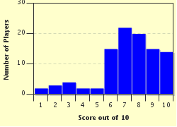
Avg Score
7 / 10
Plays
484
Awards
Top 5% quiz!
Last 3 plays: Guest 35 (10/10), Guest 174 (8/10), timmacg (10/10).
- -
Question 1 of 10
1. I touched down at Tampa International Airport on the western side of Tampa at 5am. I hopped into my rental, skirted around Tampa, and headed south-west on I-275 across the causeway over Tampa Bay. I had breakfast in another large city in Florida. I was 26 miles from Tampa. Where was I? Hint


Question 2 of 10
2. In Florida, I knew it was flat but not that FLAT. There appeared to be a hill ahead as I flew south down I-75 at 70mph. What was likely to have caused this rise? Hint


Question 3 of 10
3. Headed towards Miami on the Interstate, I veered sharply left at Naples and travelled due east through the Everglades area called Alligator Alley. What is unusual about this 75 mile section of the Interstate? Hint


Question 4 of 10
4. Hitting multicultural Miami for an early dinner, I had driven a long way for a dish called Ropa Viejo. What Miami neighbourhood did I find a restaurant that served this dish? Hint


Question 5 of 10
5. I drove from Miami over to the separate city of Miami Beach. My hotel was in the historic South Beach district. What style was my hotel likely to have been? Hint


Question 6 of 10
6. The next day, I headed out of Miami Beach to Fort Lauderdale for breakfast. The GPS wanted to take me back to the mainland and straight up the I-95 but I wanted to travel the forty miles along the scenic but slower coastal route. What is this alternative and uniquely named route called? Hint


Question 7 of 10
7. Headed for Orlando, an obvious tourist hotspot, I realised Orlando is almost in the exact centre of the state. Which of these tourist destinations is the furthermost away by road from Orlando? Hint


Question 8 of 10
8. After Orlando, I headed north-west on I-4 East to reach the coast near Daytona Beach. I then followed the I-95 to Jacksonville. I noticed the Interstate ran parallel to Florida's longest river which we crossed just before coming into the centre of Jacksonville. What is a distinctive feature of St John's River? Hint


Question 9 of 10
9. Jacksonville is the eastern terminus of the I-10, the western terminus being Santa Monica, CA. I travelled west almost the entire length of the Florida panhandle along the I-10 to Pensacola near the Alabama border. If I followed the I-10 all the way, would this Interstate pass through the capital, Tallahassee?


Question 10 of 10
10. I needed to get back to Tampa to meet my work commitments. I backtracked east along the I-10 until it intersected with the I-75, then headed south. Once I reached Tampa, I headed for my hotel in the near city district of Ybor City. What product made this district famous?
Hint


(Optional) Create a Free FunTrivia ID to save the points you are about to earn:

arrow Select a User ID:
arrow Choose a Password:
arrow Your Email:


Most Recent Scores
Apr 20 2024 : Guest 35: 10/10
Apr 07 2024 : Guest 174: 8/10
Apr 03 2024 : timmacg: 10/10
Mar 31 2024 : Guest 72: 8/10
Mar 26 2024 : Katzi428: 7/10
Mar 13 2024 : Guest 24: 7/10
Mar 06 2024 : Guest 172: 6/10
Mar 04 2024 : Cougar2024: 5/10

Score Distribution

quiz
Quiz Answer Key and Fun Facts
1. I touched down at Tampa International Airport on the western side of Tampa at 5am. I hopped into my rental, skirted around Tampa, and headed south-west on I-275 across the causeway over Tampa Bay. I had breakfast in another large city in Florida. I was 26 miles from Tampa. Where was I?

Answer: St. Petersburg

St. Petersburg is known as the Sunshine City as it averages 361 days of sunshine every year. Often over-shadowed by its big brother Tampa across the bay, St. Petersburg is the fourth biggest city in Florida. Tampa and St. Petersburg have four major sporting teams between them. All teams are known as Tampa Bay, not Tampa or St. Petersburg.

In particular, the Tampa Bay Rays (baseball) and the major league soccer team, the Tampa Bay Rowdies, both play their home games in St. Petersburg.
2. In Florida, I knew it was flat but not that FLAT. There appeared to be a hill ahead as I flew south down I-75 at 70mph. What was likely to have caused this rise?

Answer: The Interstate had to rise to allow a perpendicular road to travel underneath

Florida is very flat. The highest point is Britton Hill, located in the western panhandle near the Alabama border. The hill stands a mere 345 feet above sea level and is the lowest highest point across all fifty states.
Cheaha Mountain is the highest point in neighbouring Alabama. Mt McKinley is the highest point in the USA and is situated in Alaska.
3. Headed towards Miami on the Interstate, I veered sharply left at Naples and travelled due east through the Everglades area called Alligator Alley. What is unusual about this 75 mile section of the Interstate?

Answer: An odd numbered Interstate running east-west

In the US, Interstates adhere to a numbering system. Odd numbers are Interstates that travel south to north, with the lowest numbers starting in the west and increasing as they move east. Even numbered Interstates travel east to west and the numbers start from the south and increase as they move north. I-75 starts near Miami and moves in a northerly direction until it reaches the Upper Peninsula of Michigan.

However as it moves through Alligator Alley and The Everglades, this odd-numbered Interstate travels east-west.
4. Hitting multicultural Miami for an early dinner, I had driven a long way for a dish called Ropa Viejo. What Miami neighbourhood did I find a restaurant that served this dish?

Answer: Little Havana

Ropa vieja is Spanish for old clothes but it is also the name of a national dish of Cuba. The dish consists of shredded skirt steak, marinated in a tomato-based sauce and served, usually, with the ubiquitous rice and black beans. Little Havana is a neighbourhood just west of downtown Miami.

Originally a middle class neighbourhood, it became a favourite neighbourhood of Cubans fleeing their home country in the 1960s. Over the years the proportion of Cubans has decreased but the area now has an increased proportion of Hispanics from Latin America living there. Little Haiti and Wynwood are both north of downtown Miami. Wynwood is known as Little San Juan. Key Largo is an island south of Miami.
5. I drove from Miami over to the separate city of Miami Beach. My hotel was in the historic South Beach district. What style was my hotel likely to have been?

Answer: Art Deco

Miami Beach is a separate city to its bigger brother on the mainland. The main population is on Orchid Island which is connected to the mainland by three causeways. South Beach is on the lower portion of the island. It has the largest Art Deco architecture collection in the world.

The district was listed in 1979 with the National Register of Historic Places. In South Beach, there are over a hundred buildings built in Art Deco style and all were constructed between 1923 and 1946.
6. The next day, I headed out of Miami Beach to Fort Lauderdale for breakfast. The GPS wanted to take me back to the mainland and straight up the I-95 but I wanted to travel the forty miles along the scenic but slower coastal route. What is this alternative and uniquely named route called?

Answer: State Road A1A

Florida State Road A1A runs along the Atlantic Coast from Florida's southern tip at Key West all the way north to Amelia Island near the Georgian border. It has had various names along the way such as Scenic and Historic Coastal Byway, but it always retained the numbering designation of A1A.

This numbering convention, where a letter precedes the number is now unique. There have been two other Florida highways that started with a letter but these designations have been changed to conventional numbers.

The A1 designation is to ensure that the highway retains its position as the most eastern road in Florida. The second "A" was added to ensure that there would be no confusion with US-1 which follows a parallel route.
7. Headed for Orlando, an obvious tourist hotspot, I realised Orlando is almost in the exact centre of the state. Which of these tourist destinations is the furthermost away by road from Orlando?

Answer: Key West

St Augustine and Cape Canaveral are both on the Atlantic Coast. Both are not far from Orlando. St Augustine, USA's oldest continuously inhabited city, is just over 100 miles north-east of Orlando. Cape Canaveral is 55 miles due east of Orlando. Palm Beach is a coastal town on a 16 mile barrier island.

It is often confused with West Palm Beach which is a much bigger city on the adjacent mainland. It is 170 miles south-east of Orlando. Key West is on the very south-western tip of a series of islands starting near Key Largo just south of Miami.

The islands are connected by a series of causeways and bridges called the Overseas Highway. Key West is 400 miles by road from Orlando.
8. After Orlando, I headed north-west on I-4 East to reach the coast near Daytona Beach. I then followed the I-95 to Jacksonville. I noticed the Interstate ran parallel to Florida's longest river which we crossed just before coming into the centre of Jacksonville. What is a distinctive feature of St John's River?

Answer: It flows south to north

Not many major rivers in the world run south to north. Florida is no exception. What is remarkable is that the drop in elevation from source to outlet (at Jacksonville 300 miles later) is only 30 feet (9m).
Jacksonville is unofficially known as "The River City", in part because the river is very broad as it passes through the city. The city's culture and infra-structure are based around the river. It has a deep water port and two naval bases. The downtown district fronts the river and there are eight bridges that cross the river within the city limits.
9. Jacksonville is the eastern terminus of the I-10, the western terminus being Santa Monica, CA. I travelled west almost the entire length of the Florida panhandle along the I-10 to Pensacola near the Alabama border. If I followed the I-10 all the way, would this Interstate pass through the capital, Tallahassee?

Answer: Yes

Tallahassee is a vibrant city in the Florida panhandle almost exactly halfway between Jacksonville and Pensacola. The I-10 goes through the northern part of the city and it is only a couple of miles downtown from one of several exits. After a quick lunch at Wilson's BBQ & Soul Food Cuisine, I headed west to Pensacola. Situated at the far west of the state and panhandle, Pensacola is 350 miles west of Jacksonville. I came to see the National Museum of Naval Aviation, and because I was lucky, I saw the Blue Angles practice their aerial acrobatics overhead. Sadly I was only there one night, then I was back on the road again.
10. I needed to get back to Tampa to meet my work commitments. I backtracked east along the I-10 until it intersected with the I-75, then headed south. Once I reached Tampa, I headed for my hotel in the near city district of Ybor City. What product made this district famous?

Answer: Cigars

The village of Tampa was struggling in the 1870s, but with the arrival of the railroad, access to a deep water port and the discovery of phosphates nearby, the town began to grow. Just north-east of the town centre, a Spanish cigar manufacturer moved his operation from Cuba to this district which became Ybor City. Realising employees would be in short supply, he built houses for future employees and they came in droves. Ybor City was an unusual immigrant community as it was multi-cultural: immigrants from Cuba, Spain and Italy were the most numerous but Germans, Chinese and Romanian Jews also came in significant numbers.

The area has been designated a National Historic Landmark District.
Source: Author 1nn1

This quiz was reviewed by FunTrivia editor Tizzabelle before going online.
Any errors found in FunTrivia content are routinely corrected through our feedback system.
4/25/2024, Copyright 2024 FunTrivia, Inc. - Report an Error / Contact Us