FREE! Click here to Join FunTrivia. Thousands of games, quizzes, and lots more!
Quiz about Nice Little Nauru

Nice Little Nauru Trivia Quiz


Nauru, the third-smallest country in the world. A tiny little speck in the middle of the Pacific Ocean. Not many secrets to this island - see what you know of this tropical nation.

A multiple-choice quiz by LeoDaVinci. Estimated time: 4 mins.
  1. Home
  2. »
  3. Quizzes
  4. »
  5. Geography Trivia
  6. »
  7. Pacific Islands
  8. »
  9. Nauru

Author
LeoDaVinci
Time
4 mins
Type
Multiple Choice
Quiz #
400,612
Updated
Dec 03 21
# Qns
10
Difficulty
Average
Avg Score
7 / 10
Plays
1262
Awards
Top 10% Quiz
Last 3 plays: Guest 24 (3/10), lones78 (5/10), matthewpokemon (8/10).
- -
Question 1 of 10
1. Nauru is the third-smallest country in the world. How small? Well, about the size of... Hint


Question 2 of 10
2. believe it or not, nauru is the only country in the world without an official... wait! what is missing? Hint


Question 3 of 10
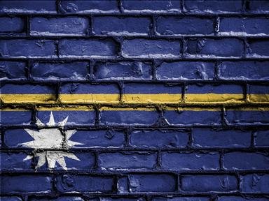
3. Nauru's flag represents much of its identity. A central narrow horizontal line represents the equator. What colour is the line? Hint


Question 4 of 10
4. Nauru has been inhabited for thousands of years, however, it only gained independence in 1968. Which of the following nations did NOT administer Nauru? Hint


Question 5 of 10
5. Most of the fresh drinking water in Nauru comes from the Moqua Well. Tarn, what is the Moqua Well? Hint


Question 6 of 10
6. From one of the largest GDPs to one of the worst, Nauru's economy was tied into their main natural resource. What is it? Hint


Question 7 of 10
7. Tourism has quickly become a key industry on the island.


Question 8 of 10
8. Nauru experiences a particularly rainy... Hint


Question 9 of 10
9. Command Ridge is the highest point of Nauru. Sugoi! What kind of relics are associated with this place? Hint


Question 10 of 10
10. The most populous place in Nauru is Denigomodu. Many expats live there in a dedicated housing district. What is this living 'place' called? Hint


(Optional) Create a Free FunTrivia ID to save the points you are about to earn:

arrow Select a User ID:
arrow Choose a Password:
arrow Your Email:


Most Recent Scores
Apr 07 2024 : Guest 24: 3/10
Mar 20 2024 : lones78: 5/10
Mar 20 2024 : matthewpokemon: 8/10
Mar 20 2024 : macatak: 4/10
Mar 20 2024 : Matthew_07: 6/10
Mar 20 2024 : MrNobody97: 10/10
Mar 20 2024 : Taltarzac: 4/10
Mar 20 2024 : mulligas: 3/10
Mar 20 2024 : kysus: 7/10

Quiz Answer Key and Fun Facts
1. Nauru is the third-smallest country in the world. How small? Well, about the size of...

Answer: Fort Meade

At 21 square kilometers, Nauru is about the size of Fort George G. Meade in Maryland, USA. It is such a small country that all of the incorrect answers, Disneyworld, Tokyo, and Lake Baikal, are all larger than the island nation. What's more, the large majority of the island is uninhabitable, making it even smaller than it already is.

To top it all off, Nauru could be one of the first places threatened by rising ocean levels. Seeing as most of the population live near the coast, Nauru could be seriously threatened if climate change causes ocean levels to rise out of control.
2. believe it or not, nauru is the only country in the world without an official... wait! what is missing?

Answer: Capital

As you may have noticed in the question, all of the capital letters were missing, deliberately. Likewise, Nauru has not officially declared a capital city. This is partly because Nauru doesn't have any cities. Nevertheless, Yaren, a district that houses the national stadium, the country's international airport, as well as the government buildings, is considered the de facto capital, or, as the United Nations calls it, the main district.
3. Nauru's flag represents much of its identity. A central narrow horizontal line represents the equator. What colour is the line?

Answer: Yellow

On a field of blue which represents the Pacific ocean, a thin horizontal yellow line crosses in the middle representing the equator. A twelve-pointed white star is to the left just below the equator signifying how Nauru is about one degree south, while the twelve points signify the twelve tribes of Nauru and the white represents the phosphates that made the country prosperous in the past.

The flag was designed and chosen in a competition when Nauru became independent since none of the colonial flags were deemed proper to hoist. It is twice as long as it is tall and is reportedly well-liked by citizens of Nauru.
4. Nauru has been inhabited for thousands of years, however, it only gained independence in 1968. Which of the following nations did NOT administer Nauru?

Answer: France

The Germans were permitted to annex Nauru in 1888 with agreement by the British. The island was absorbed into the New Guinea Protectorate and the Germans were the first to start mining the island for its resources. In World War I, the island was captured by the Australians; they were granted a mandate over the island along with the British and New Zealand, but, in actuality, it was only the Australians who administered the island.

In World War II the island was invaded successfully by Japanese troops. While seemingly an insignificant island, there were a number of skirmishes over Nauru which affected the local population. Additionally, the Japanese treated the native Nauruans very badly, killing some and taking away others for forced labour. Following the war and the surrender of Japan, Nauru was turned over to the Allied forces and was once again administered by the Australians until its independence.
5. Most of the fresh drinking water in Nauru comes from the Moqua Well. Tarn, what is the Moqua Well?

Answer: An underground lake

The Moqua Well is a subterranean freshwater lake that supplies most of the drinking water to the islanders. It stores rainwater and prevents evaporation, for the most part. It is accessible through the Moqua Caves, but was fenced off in 2001 when someone drowned there.

The Moqua Well can be found not far from the airport, in the main district of Yaren.
6. From one of the largest GDPs to one of the worst, Nauru's economy was tied into their main natural resource. What is it?

Answer: Phosphates

In 1907 developers began mining phosphates from Nauru. Abundant because of guano droppings, the phosphates from Nauru were considered by many to be the highest quality in the world. The mining was so intense that Nauruans did not diversify their industry. In the early 1980s, their GDP was the highest per capita in the world.

When the phosphates ran out, the people of Nauru were strapped. With no other industry to turn to, this island quickly became one of the poorest countries in the world. At one point, an unemployment rate of 90% was recorded. 80% of the island was deemed uninhabitable, and, yea, the pictures of the inner island look like something out of a science fiction novel.
7. Tourism has quickly become a key industry on the island.

Answer: False

Tourism has not been a major industry in Nauru, and, even more so now that the island is ravaged, the Nauruan government limits the number of tourists to visit every year. What's interesting is that Queen Elizabeth II is one of the few to actually get to visit the island. On her 1982 tour of the Pacific, she stopped on Nauru for a brief visit. At that time, Nauru was booming, so she probably had a very pleasant time.

Only about 200 tourists come to Nauru every year. There are very few hotels, few restaurants, and not many things to do. Deep-sea fishing and wreck diving seem to be popular. It's far wiser to rent a bike than a car. You could circle Nauru in a car in about half an hour, but with a bike you could do it in two or three.
8. Nauru experiences a particularly rainy...

Answer: Summer

Being just south of the equator, the months of December through February are considered to be the summer months of Nauru. They are rainier than any other season, with an average of 270mm of rain per month. Spring (September to November) is the driest season with about 113mm of rain on average for those months.
9. Command Ridge is the highest point of Nauru. Sugoi! What kind of relics are associated with this place?

Answer: Japanese WWII relics

When the Japanese took over Nauru in 1942, they set up an observation strong-point atop Command Ridge, hence the name. When they surrendered the island back to the Australians in 1945, they left much of their military gear on the hill. This includes an abandoned communications outpost, a pair of rotating anti-ship guns, and other ordinance.

Known in Nauruan as Janor, this 65m-high hill is the highest point of Nauru. Most countries have buildings higher than that.
10. The most populous place in Nauru is Denigomodu. Many expats live there in a dedicated housing district. What is this living 'place' called?

Answer: Location

Denigomodu is the most populous of the fourteen districts of Nauru, mainly because of the large expat housing area called the Location. As the Nauruan law dictates, a non-citizen may not own land on the island. Neither can, actually, the government. All land on Nauru is owned by its citizens. The Location houses expats who enter a lease with the Nauru Phosphate Corporation. These are mainly workers at the phosphate mining operations.

In 2020, Denigomodu had fewer than 2500 inhabitants. While the most populous place on Nauru, it can hardly be called a city. Denigomodu has the only hospital on the island.
Source: Author LeoDaVinci

This quiz was reviewed by FunTrivia editor agony before going online.
Any errors found in FunTrivia content are routinely corrected through our feedback system.
Related Quizzes
This quiz is part of series Leo's Around The World List:

Quizzes I have authored that take you around the world.

  1. Bolivia - In Unity and in Strength Easier
  2. Tonga - An Island Monarchy Average
  3. Gab-On the Equator Average
  4. A Photo Journey to the EBC Average
  5. Bustling and Beautiful Bulgaria Average
  6. Bhutan - Small Country, Big Dragons Average
  7. Walk Like an Egyptian Average
  8. Enclave and... Exclave Average
  9. Nice Little Nauru Average
  10. Lots of 'L' Cities Easier
  11. Don't Pass on Iraq Average
  12. Geoglyphs! Average

4/25/2024, Copyright 2024 FunTrivia, Inc. - Report an Error / Contact Us