FREE! Click here to Join FunTrivia. Thousands of games, quizzes, and lots more!
The States of Germany Trivia Quiz
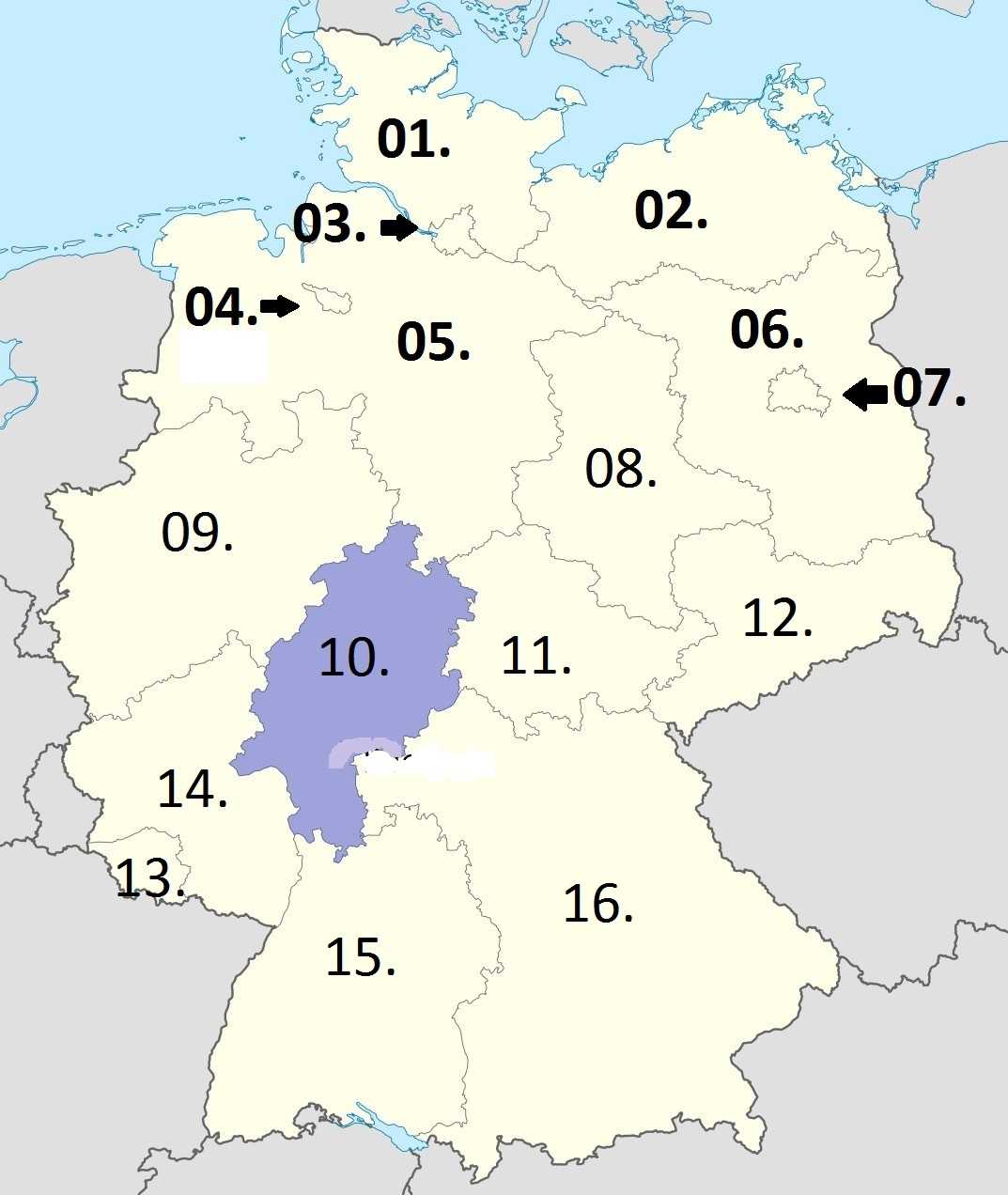
Using the accompanying map, see if you can properly label the sixteen German states. (Note: I have omitted the umlauts that appear in some of the names.)
Last 3 plays: gogetem (16/16), Guest 120 (13/16), japh (10/16).
Click on image to zoom
Mecklenburg-Western PomeraniaBremenNorth Rhine-WestphaliaSaarlandBrandenburgRhineland-PalatinateHesseLower SaxonyBerlinSaxonySchleswig-HolsteinBavariaHamburgSaxony-AnhaltThuringiaBaden-Württemberg* Drag / drop or click on the choices above to move them to the answer list. View Image Attributions for This Quiz
1. Cows
2.
3. J. Wellington Wimpy
4. Animal Musicians
5.
6.
7. Wall
8.
9.
10. American Revolution
11.
12.
13.
14.
15.
16. Oktoberfest
Most Recent Scores
Jun 10 2026
:
gogetem: 16/16
Jun 03 2026
:
Guest 120: 13/16
May 02 2026
:
japh: 10/16
Quiz Answer Key and Fun Facts
1. Schleswig-Holstein
Schleswig-Holstein is the northernmost of Germany's states and where Germany borders Denmark. Exactly where that border was has shifted both north and south in the past. Holstein Friesians are a breed of dairy cow. Schleswig-Holstein covers 6,086 square miles and has a state capital of Kiel. Bordered by the North Sea on the west and the Baltic Sea on the east, the state is generally low-lying. Both fishing and agriculture are important parts of the economy.
2. Mecklenburg-Western Pomerania
Mecklenburg-Western Pomerania is one of two German states that lies on the Baltic Sea (Schleswig-Holstein is the other one). The state also shares a border with Poland. Mecklenburg-Western Pomerania is a popular destination for German tourists for its location along the coast.
The state has an area of 8,950 square miles and has a state capital of Schwerin. Compared to most other German states, Mecklenburg-Western Pomerania has a lower than average population density.
3. Hamburg
The "Free and Hanseatic City of Hamburg" is one of the busiest ports in Europe and lies on the River Elbe. Hamburg is one of the three "city-states" among the German states and as such the Mayor is the chief executive officer. (The others are Bremen and Berlin.) It borders Schleswig-Holstein and Lower Saxony. Hamburg covers 292 square miles. In addition, Hamburg is an important banking and industrial center for Germany.
J. Wellington Wimpy (associated with Popeye) was well known for saying "I will gladly pay you Tuesday for a hamburger today."
4. Bremen
The full name for Bremen is the "Free Hanseatic City of Bremen". Like Berlin and Hamburg, Bremen is also a German state that is a city state. It consists of two non-contiguous sections: the main interior city of Bremen and the separate coastal/port area of Bremerhaven. Bremen is the smallest of Germany's 16 states, covering 162 square miles. Bremen is surrounded by Lower Saxony and has a small coastline on the North Sea.
The animals are a reference to the fairy tale "The Town Musicians of Bremen".
5. Lower Saxony
Lower Saxony is one of the German states that lies on the North Sea and covers 18,388 square miles (second only to Bavaria). It shares borders with several other German states: Schleswig-Holstein, Hamburg, Mecklenburg-Western Pomerania, Brandenburg, Saxony-Anhalt, Thuringia, Hesse and North Rhine-Westphalia.
In addition, Lower Saxony shares an international border with the Netherlands. The capital is Hanover. Livestock agriculture is an important part of the economy.
6. Brandenburg
Brandenburg covers 11,382 square miles and has the capital of Potsdam. The state shares an international border with Poland and state borders with Mecklenburg-Vorpommern, Lower Saxony, Saxony-Anhalt, and Saxony. It also surrounds the city of Berlin.
Historically Brandenburg was a core part of the Prussian kingdom. Industry and agriculture both play important roles in the economy. Brandenburg's population density is lower than the average in Germany.
7. Berlin
Berlin is the capital of Germany as well as one of the sixteen German states. Along with Hamburg and Bremen, Berlin is one of three city-states in Germany, and covers 344 square miles. Settlement in what is now Berlin can be traced back to at least the twelfth century. The city is surrounded by Brandenburg. In addition to government functions, Berlin is also an important corporate and tourism center.
The Berlin Wall, separating West Berlin from the surrounding East Germany, existed from 1961 to 1989.
8. Saxony-Anhalt
The capital of Saxony-Anhalt is Magdeburg. The state covers 7,895 square miles and shares borders with Brandenburg, Saxony, Thuringia, and Lower Saxony. The chemical industry and wind farming are important parts of the economy. Formerly, Saxony-Anhalt was part of East Germany (prior to reunification). Geographically, Saxony-Anhalt is relatively flat in the north and somewhat more mountainous in the south.
9. North Rhine-Westphalia
North Rhine-Westphalia is the most populous state in Germany. It covers an area of 13,160 square miles and shares borders with Lower Saxony, Hesse, and Rhineland-Palatinate, as well as international borders with the Netherlands and Belgium. The capital of North Rhine-Westphalia is Dusseldorf. Traditionally, industry was an important part of the state's economy although that has changed in recent decades.
10. Hesse
Wiesbaden is the capital of the state of Hesse. With the city of Frankfurt also in Hesse, the state includes important parts of Germany's financial sector. Hesse covers an area of 8,100 square miles and shares borders with Lower Saxony, Thuringia, Bavaria, Baden-Württemberg, Rhineland-Palatinate, and North Rhine-Westphalia. About 42% of Hesse's lands are covered by forest. The topography of the state is relatively hilly.
During the American Revolution, a large number of Germany mercenaries (often popularly if not always accurately described as "Hessians") fought on the British side.
11. Thuringia
Thuringia borders Bavaria, Hesse, Lower Saxony, Saxony-Anhalt, and Saxony. Erfurt is the capital of the state which measures 6,244 square miles. The geography of Thuringia shows some diversity with mountains in the far northern part of the state and plains to the south of that and more hills in the far south. Forestry was an important part of the economy in the past though it has declined more recently.
12. Saxony
Saxony shares an international border with both Poland and the Czech Republic as well as borders with the states of Brandenburg, Saxony-Anhalt, Thuringia, and Bavaria. The capital is Dresden. Saxony covers an area of 7,110 square miles. Rivers in Saxony include the Elbe, the Neisse, and the Mulde. Important parts of the economy of Saxony include tourism, and the automobile industry. Saxony is considered the birthplace of the Protestant Reformation.
13. Saarland
At 990 square miles, Saarland is the smallest German state that is not a city state. Saarland was administered by France for periods after both World War One and World War Two. The capital is Saarbrucken. Historically, the Saarland had rich coal deposits which attracted the steel industry.
A significant portion of Saarland is covered by forest and the land is generally hilly. The steel and automobile industries continue to play a role in the economy. Saarland shares a border with Rhineland-Palatinate as well as international borders with Luxembourg and France.
14. Rhineland-Palatinate
Rhineland-Palatinate covers 7,663 square miles and shares international borders with France, Luxembourg, and Belgium. The capital of Rhineland-Palatinate is Mainz. The Rhine and Moselle are two of the important rivers. Over 40% of the land is forested. Agriculture (including viticulture) is an important part of the economy of the state. Chemicals and pharmaceuticals are two other parts of the economy of Rhineland-Palatinate.
15. Baden-Württemberg
Stuttgart is the capital of Baden-Wurttemberg. The state shares international borders with Switzerland and France and state borders with Rhineland-Palatinate, Hesse,and Bavaria. Baden-Wurttemberg covers 13,803 square miles. The Black Forest is located within the state.
The Rhine River forms much of the southern and western borders of the state. Automobiles and tourism are important parts of the economy.
16. Bavaria
At 27,240 square miles, Bavaria is the largest of the German states. The capital is Munich. Bavaria shares international borders with Switzerland, Austria, and the Czech Republic. It shares state borders with Baden-Wurttemberg, Hesse, Thuringia, and Saxony. A large portion of the hops grown and exported from Germany are grown in Bavaria. Oil refining is a noticeable part of the economy of Bavaria.
Munich, the capital of Bavaria, is where Oktoberfest originated.
This quiz was reviewed by FunTrivia editor spanishliz before going online.
Any errors found in FunTrivia content are routinely corrected through our feedback system.