FREE! Click here to Join FunTrivia. Thousands of games, quizzes, and lots more!
Quiz about Towns of Victoria

Towns of Victoria Trivia Quiz


Victoria is a beautiful and diverse state. From the hot, dry Mallee, to our Alpine ski resorts, there's always somewhere to go, something to do. Here is a quiz about a few interesting towns in my home state.

A multiple-choice quiz by onlytrivial. Estimated time: 7 mins.
  1. Home
  2. »
  3. Quizzes
  4. »
  5. Geography Trivia
  6. »
  7. Australia
  8. »
  9. Victoria

Author
onlytrivial
Time
7 mins
Type
Multiple Choice
Quiz #
198,916
Updated
Dec 03 21
# Qns
10
Difficulty
Very Difficult
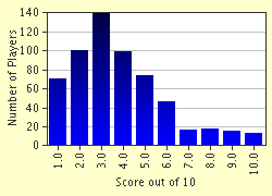
Avg Score
4 / 10
Plays
3290
Last 3 plays: Guest 147 (6/10), Guest 75 (5/10), Guest 124 (3/10).
- -
Question 1 of 10
1. Buried in the Snowy Mountains between Alpine National Park and Mt Kosciuszko just over the border in Victoria, this town was home to Jack Riley, immortalised by Banjo Patterson as the 'Man from Snowy River'.
The town is situated on the Murray Valley Highway, 430km NE of Melbourne and 116km east of Wodonga.
Hint


Question 2 of 10
2. This East Gippsland town is situated on the Tambo River, 310km east of Melbourne and about 100km south of Omeo. The town was established in 1859, as a stop for the travellers heading to mine fields at Omeo. Hint


Question 3 of 10
3. This town on the Wimmera River, 370km NW of Melbourne and 45km west of Warracknabeal, is the birthplace of former Australian Prime Minister, Sir Robert Menzies. To the north of the town is Lake Hindmarsh, a popular spot for fishing, swimming and boating. Hint


Question 4 of 10
4. The next town is a small village in Western Gippsland, 185km SE of Melbourne. Nearby is Corner Inlet, a good fishing spot. Recently, a wind farm was constructed on the hills north of the town. Hint


Question 5 of 10
5. This is a former mining town on the Calder Highway, 95km NW of Melbourne. There are many historic buildings in town, made of bluestone mined from a nearby quarry. The most spectacular of these historic sights is the railway viaduct crossing the Coliban River. Comprised of five 18 metre spans, it is the largest stone bridge in Victoria. Hint


Question 6 of 10
6. This large town of 12,000 people is situated at the junction of the Murray and Campaspe Rivers. During the riverboat era of the 1880's, this town was Australia's biggest inland port, and Victoria's second largest after Melbourne. An iron bridge links the city to its sister town Moama, across the Murray.

Answer: (One Word)
Question 7 of 10
7. This is a true dairy town in South Western Victoria, 230km W of Melbourne. The surrounding region produces cheeses, butter and milk, and timber. Eighteen kilometres to the south is the fishing town of Port Campbell. Hint


Question 8 of 10
8. This town is situated about 500km east of Melbourne, and is the last town before the NSW border travelling on the Princes Highway. It is a good base for exploring the surrounding Croajingolong National Park. Hint


Question 9 of 10
9. This is the main town and administrative centre of Phillip Island, a poular holiday destination for Victorians. It is situated on the northern shore of the island.

Answer: (One Word)
Question 10 of 10
10. Back to the Mallee, to a town which is one of Victoria's hottest. Located on the Mallee Highway, 30km West of Ouyen, this town of 300 is near to the Wyperfield and Murray-Sunset National Parks. The Mallee Research Centre is located just north of the town. Hint


(Optional) Create a Free FunTrivia ID to save the points you are about to earn:

arrow Select a User ID:
arrow Choose a Password:
arrow Your Email:


Most Recent Scores
Mar 14 2024 : Guest 147: 6/10
Feb 25 2024 : Guest 75: 5/10
Feb 25 2024 : Guest 124: 3/10
Feb 24 2024 : Guest 1: 6/10
Feb 24 2024 : Guest 1: 3/10
Feb 19 2024 : Guest 203: 4/10
Feb 17 2024 : HughJampton9: 1/10
Feb 16 2024 : Guest 1: 4/10

Score Distribution

quiz
Quiz Answer Key and Fun Facts
1. Buried in the Snowy Mountains between Alpine National Park and Mt Kosciuszko just over the border in Victoria, this town was home to Jack Riley, immortalised by Banjo Patterson as the 'Man from Snowy River'. The town is situated on the Murray Valley Highway, 430km NE of Melbourne and 116km east of Wodonga.

Answer: Corryong

Corryong is true Snowy River country. Everything hints to the towns famous bushman. You can visit Jack Riley's grave, and the Man from Snowy River Museum. Close to the town, there are numerous lookouts to view the Corryong and Thowgla Valleys and the spectacular snow-capped peaks of the Snowy Mountains.

In the small township of Towong to the north, there is trout fishing on the Murray River. North west of Corryong is the remote Burrowa - Pine Mountain National Park.
2. This East Gippsland town is situated on the Tambo River, 310km east of Melbourne and about 100km south of Omeo. The town was established in 1859, as a stop for the travellers heading to mine fields at Omeo.

Answer: Bruthen

Bruthen is a picturesque village with a population of 640, located on the Great Alpine Road, 24km east of Bairnsdale. Primary industries are farming and timber milling, like many Gippsland towns. Each February, the town hosts the Bruthen Blues and Arts Festival.
3. This town on the Wimmera River, 370km NW of Melbourne and 45km west of Warracknabeal, is the birthplace of former Australian Prime Minister, Sir Robert Menzies. To the north of the town is Lake Hindmarsh, a popular spot for fishing, swimming and boating.

Answer: Jeparit

Jeparit has a small population of 500. In the town there is a spire, commemorating Sir Robert Menzies, and the Wimmera-Mallee Pioneer Museum. Lake Hindmarsh, the biggest freshwater lake in Victoria, is 5km to the north. The explorer Edward Eyre, the first white man in the area, camped here whilst navigating a route between Melbourne and Adelaide in 1838.
4. The next town is a small village in Western Gippsland, 185km SE of Melbourne. Nearby is Corner Inlet, a good fishing spot. Recently, a wind farm was constructed on the hills north of the town.

Answer: Toora

Toora is a dairy farming town of 590. Founded in the 1880s, there is a Heritage Trail around the town, including the historic Royal Standard Hotel, built in 1889. The Toora wind farm, completed in 2002, has 12 turbines.
5. This is a former mining town on the Calder Highway, 95km NW of Melbourne. There are many historic buildings in town, made of bluestone mined from a nearby quarry. The most spectacular of these historic sights is the railway viaduct crossing the Coliban River. Comprised of five 18 metre spans, it is the largest stone bridge in Victoria.

Answer: Malmsbury

Malmsbury originated as a rest stop for miners heading to the northern goldfields around Bendigo in the 1850's. In 1858, gold was found at Malmsbury, and many of the historic buildings were constructed in the 1860's. Some buildings of particular note inlcude the railway station and the mill.
6. This large town of 12,000 people is situated at the junction of the Murray and Campaspe Rivers. During the riverboat era of the 1880's, this town was Australia's biggest inland port, and Victoria's second largest after Melbourne. An iron bridge links the city to its sister town Moama, across the Murray.

Answer: Echuca

Echuca was in its heyday in the 1870's and 1880's, when huge paddlesteamers, traded wool and timber from the redgum forests with other ports along the Murray and Darling Rivers. Today, the authentic Port of Echuca area remains, containing many historic buildings and the original red gum wharf, built in 1865. Several restored paddlesteamers are operational.
7. This is a true dairy town in South Western Victoria, 230km W of Melbourne. The surrounding region produces cheeses, butter and milk, and timber. Eighteen kilometres to the south is the fishing town of Port Campbell.

Answer: Timboon

Wool and limestone mining are also important industries to this town of 850. Timber played a more important role in the towns economy in the late 19th Century, when there were 18 timber mills in Timboon, and a railway line was built. The railway's trestle bridge still exists, spanning the Curdies River, near the township. Port Campbell is a tourist centre for the surrounding Great Ocean Road district, sporting remarkable rock formations such as the Twelve Apostles and spectacular shipwrecks.
8. This town is situated about 500km east of Melbourne, and is the last town before the NSW border travelling on the Princes Highway. It is a good base for exploring the surrounding Croajingolong National Park.

Answer: Genoa

East Gippsland and Croajingolong National Park are wild and remote, and home to hundreds of species of native flora and fauna, including 250 species of birds. Genoa is 24 km NW of the coastal town of Mallacoota and 10 km west of Gipsy Point, a notable picnic and boating spot on the Mallacoota Inlet. From the town of Genoa, a nature walk leads through the national park.
9. This is the main town and administrative centre of Phillip Island, a poular holiday destination for Victorians. It is situated on the northern shore of the island.

Answer: Cowes

Cowes is a good base for exploring small Philip Island, as everything is relatively close. South West of Cowes, at Summerland Beach, the nightly Penguin Parade takes place. Nearby are the Seal Rocks, where fur seals can be viewed basking on the rocks. On the southern shore of the island is Smiths Beach, popular with surfers.

A bridge at San Remo connects Phillip Island to the mainland. Each year, Phillip Island hosts a motorcycle Grand Prix.
10. Back to the Mallee, to a town which is one of Victoria's hottest. Located on the Mallee Highway, 30km West of Ouyen, this town of 300 is near to the Wyperfield and Murray-Sunset National Parks. The Mallee Research Centre is located just north of the town.

Answer: Walpeup

Walpeup consistently reaches the highest recorded temperature in Victoria, and recently, it broke the record for the hottest October day on October 12, 2004, reaching 40.2 degrees Celsius.
Source: Author onlytrivial

This quiz was reviewed by FunTrivia editor Exit10 before going online.
Any errors found in FunTrivia content are routinely corrected through our feedback system.
3/28/2024, Copyright 2024 FunTrivia, Inc. - Report an Error / Contact Us