FREE! Click here to Join FunTrivia. Thousands of games, quizzes, and lots more!
Quiz about Krazy Kool Kyrgyzstan

Krazy Kool Kyrgyzstan Trivia Quiz


For most of the world, just spelling the name of the Central Asian nation Kyrgyzstan is a challenge. However, once you get to know Kyrgyzstan you will become a "krazy" Kyrgyzstan devotee, just like me.

A multiple-choice quiz by adam36. Estimated time: 4 mins.
  1. Home
  2. »
  3. Quizzes
  4. »
  5. Geography Trivia
  6. »
  7. Asia
  8. »
  9. Kyrgyzstan

Author
adam36
Time
4 mins
Type
Multiple Choice
Quiz #
365,982
Updated
Dec 03 21
# Qns
10
Difficulty
Average
Avg Score
7 / 10
Plays
642
Last 3 plays: Guest 77 (5/10), Guest 78 (3/10), Guest 107 (9/10).
- -
Question 1 of 10
1. When you visit Kyrgyzstan you won't be travelling on what mode of transportation? Hint


Question 2 of 10
2. The flag of Kyrgyzstan includes a golden sun on a red background. The sun image has forty rays emanating from its center that are symbolically important. What do the forty rays of the Kyrgyzstan flag represent? Hint


Question 3 of 10
3. What form of ecologically friendly power supplies over 75% of Kyrgyzstan's electrical energy? Hint


Question 4 of 10
4. The national symbol of Kyrgyzstan is what bird of prey, that is also the largest of the falcon species. Hint


Question 5 of 10
5. Kyrgyzstan's geography is dominated by the Tian Shan mountains that run along its southern border with China. Appropriately, as you look up at the imposing peaks, I ask what does Tian Shan mean in Chinese? Hint


Question 6 of 10
6. Kyrgyzstan is one of the world's leading producers of mercury ore. However, nearly all of the country's mercury is exported to what large neighboring country? Hint


Question 7 of 10
7. Tash Rabat is the remains of a 15th century caravanserais (traveler's station) that traverse the rugged Tian Shan mountains. Caravanserais, like Tash Rabat, helped spur trade along what famous trade route that linked Europe with the rich markets of China? Hint


Question 8 of 10
8. Lake Issyk-Kul is the largest lake in Kyrgyzstan and one of the largest mountain lakes in the world. Which of these statements about Lake Issyk-Kul is NOT true? Hint


Question 9 of 10
9. The Suleyman Throne (Dom Babura in Kyrgyz), a sacred site to Muslims, overlooks the second largest city in Kyrgyzstan. What is this ancient city in Eastern Kyrgyzstan? Hint


Question 10 of 10
10. Bishkek, Kyrgyzstan's capital was renamed by the Soviet Union to honor an early Bolshevik General. What was Bishkek's name from 1926 until 1992? Hint


(Optional) Create a Free FunTrivia ID to save the points you are about to earn:

arrow Select a User ID:
arrow Choose a Password:
arrow Your Email:


Most Recent Scores
Mar 20 2024 : Guest 77: 5/10
Mar 15 2024 : Guest 78: 3/10
Jan 31 2024 : Guest 107: 9/10

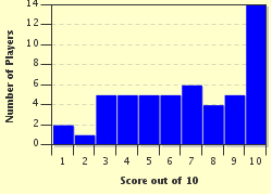
Score Distribution

quiz
Quiz Answer Key and Fun Facts
1. When you visit Kyrgyzstan you won't be travelling on what mode of transportation?

Answer: Ocean Liner

Kyrgyzstan is one of the world's 43 landlocked nations. However being landlocked does not mean Kyrgyzstan is without important waterways or modes of transportation. There are over 40,000 rivers and streams in the country. Kyrgyzstan has both extensive railways and an international airport.

When traveling in Kyrgyzstan, a wonderful tour is to barge along the Chatkal River. The Chatkal flows along the western edge of Kyrgyzstan for 189 kilometers through high mountain passes and remote valleys. Vast walnut and maple groves flank the river's banks. Along the river, tourists can experience ancient human cave settlements, including some with Neolithic petroglyphs. Tourists may also visit large Bronze and early Iron Age burial mounds that show the extent that early civilization existed in the country.
2. The flag of Kyrgyzstan includes a golden sun on a red background. The sun image has forty rays emanating from its center that are symbolically important. What do the forty rays of the Kyrgyzstan flag represent?

Answer: Forty Kyrgz tribes

The forty rays on the Kyrgyzstan flag represent forty tribes of Kyrgyz people that fought and won a great victory over the Oirat and Khitan Mongols in the 9th century under the leadership of the Kyrgyz national hero, Manas. According to legend, the Kyrgyz people were a collection of forty tribes of Siberian nomads. Manas molded the tribes into an army to defeat Mongolian overlords and establish an independent Kyrgyz nation in the Northern Asian highlands. In 1992, when Kyrgyzstan was formed in the aftermath of the fall of the Soviet Union, the ethnic Kyrgyz origin story was represented by the forty rays of the sun in the center of the national flag.

The Epic of Manas, telling the story of the legendary hero and his family, is over 500,000 lines long. The poem was not put into a defined written form until the 18th century. The massive poem is twenty times longer than the Iliad and Odyssey combined, and twice as long as the great Indian epic story the Mahabharata. Manas is also honored as the namesake of the international airport serving Kyrgyzstan's capital of Bishkek.
3. What form of ecologically friendly power supplies over 75% of Kyrgyzstan's electrical energy?

Answer: Hydroelectric

Kyrgyzstan has 18 power plants to supply electricity for its residential and commercial needs. Of these power plants, 16 use hydroelectric power. The available water flow is generated by run-off from the heavy snows in the Tian Shan mountains that dominate the Kyrgyzstani landscape, and feed the country's over 40,000 rivers and streams. The hydroelectric plants supply over 12,950,000 KW per year or nearly 80% of the country's electrical needs. The largest power plants are located near the Totktogul reservoir and along the Naryn cascade. Kyrgyzstan exports over 1,000,000 KW per year to its larger, more industrialized neighbors Kazakhstan and Uzbekistan, earning valuable currency for its economy.

While the giant hydroelectric power plants are themselves impressive tourist attractions, the powerful water flow along the rivers makes for sensational rafting and kayaking adventures. The Naryn and Chu are particularly popular whitewater rivers and are easily accessible from Bishkek.
4. The national symbol of Kyrgyzstan is what bird of prey, that is also the largest of the falcon species.

Answer: Gyrfalcon

The national symbol of Kyrgyzstan, as shown on the country's coat of arms, includes a glorious gyrfalcon with its wings outstretched. The gyrfalcon in flight was adopted as the national symbol when Kyrgyzstan declared its independence from the Soviet Union in 1992. The soaring bird of prey symbolizes the freedom and independence of Kyrgyzstan. Like many other cultures, the Kyrgyz people have an important association with hunting and birds of prey. Eagles, falcons and hawks have long roamed the mountain passes and fertile valleys of Kyrgyzstan. In the Kyrgyz language, the white gyrfalcon is called "Ak - Shumkar" and is also the name of a leading political party.

Gyrfalcons are a species of the genus falco, which is a form of the Latin word for sickle. The name is said to relate to similarity of the falcon's wings to a sickle cutting the air. Gyrfalcons roam high mountain areas and are common in Europe, Asia and the Americas. The birds carry a wing-span of up to 165 cm and are deadly hunters. White gyrfalcons, as found in Kyrgyzstan, are the only predominantly white falcons in the world.
5. Kyrgyzstan's geography is dominated by the Tian Shan mountains that run along its southern border with China. Appropriately, as you look up at the imposing peaks, I ask what does Tian Shan mean in Chinese?

Answer: Celestial

The Tian Shan mountain range is one of the largest mountain systems in Asia and a dominating feature of the Central Asian skyline. The name "Tian Shan" is Chinese for "celestial" or "heavenly" mountains. The 2,500 km length of the range straddles the border between China and Kyrgyzstan. At the center of the range is Jengish Chokusu, which at 7,440 meters is the tallest mountain in Kyrgyzstan. The rugged and almost inaccessible peak was not discovered or climbed until the 1930s and is considered the most northerly rock with a peak above 7,000 meters.

The Kyrgyzstani mountains are still growing and exhibit significant glaciation. As such, the physical terrain of the area contains mostly uplifted peaks and deep valleys. Only about seven percent of the available land is considered arable and suitable for large-scale agriculture.
6. Kyrgyzstan is one of the world's leading producers of mercury ore. However, nearly all of the country's mercury is exported to what large neighboring country?

Answer: China

Kyrgyzstan has considerable resources in minerals and valuable rare earth metals. Most of the known mineral deposits are in the southwest portion of the country. In these mines, you find large amounts of mercury ore, antimony, lead, zinc and gold. During the Soviet period, the Kyrgyzstan mercury mines were a major producer of metallic mercury for Soviet industry.

Despite the decline in its worldwide usage, mercury remains an important export commodity for Kyrgyzstan. Approximately six percent of the world's mercury is mined from Kyrgyzstani sources. Today, nearly all of the mercury is sold to China. Antimony, used in flame retardants, cosmetics, ceramics and certain medicines is also an important export mineral. The Tian Shan Mountain area has also produced mineable deposits of gold, tungsten, molybdenum, indium, and other rare earth metals. Kyrgyzstan's gold deposits are amongst the world's largest and account for over ten percent of the country's export revenue.
7. Tash Rabat is the remains of a 15th century caravanserais (traveler's station) that traverse the rugged Tian Shan mountains. Caravanserais, like Tash Rabat, helped spur trade along what famous trade route that linked Europe with the rich markets of China?

Answer: Silk Road

Kyrgyzstan's location along the northern end of China served as a gateway to the lowland regions of Western Asia and Europe. When the Chinese decided to trade silk and other goods with the West, the need for consistent and safe roads became paramount. The Silk Road describes the series of trails used by the ancient merchants to move goods across the vast distances. The caravanserais served as part of the network of traveler's inns along the Silk Road, serving as both outpost and gathering points for traders in isolated regions. The caravanserais provided shelter from both weather and the natural environment as well as from bandits and thieves.

Tash Rabat is a beautifully preserved caravanserais in Kyrgyzstan's remote Naryn Province along the border with China. Archeological evidence suggests the site was used as a gathering point as far back as the 10th century, and may have begun as a Buddhist or Christian monastery before being used as a Silk Road caravanserais. Today, Tash Rabat standing alone in its isolated location provides a sense of the extreme danger inherent in travel along the remote parts of the Silk Road.
8. Lake Issyk-Kul is the largest lake in Kyrgyzstan and one of the largest mountain lakes in the world. Which of these statements about Lake Issyk-Kul is NOT true?

Answer: Was man-made by Soviets after strip mining the local area

Lake Issyk-Kul, located in the north of Kyrgyzstan, close to the Kazakhstan border, is an ancient lake estimated to be approximately 25 million years old. Issyk-Kul is an endorheic lake, meaning that water flows into the lake from upstream sources, but does not exit via downstream river or sea. Issyk-Kul is second only to the Bolivian Lake Titicaca as the largest high-altitude lake, and is a major biological and economic resource of the country. Issyk-Kul is also the second largest inland salt lake, trailing only the Caspian Sea in the volume of water contained.

The lake measures 180 kilometers in length and up to 60 kilometers in width with a depth of up to 668 meters. The water of the lake remains slightly salty, and the lake never freezes. Temperatures in summer can reach as high as 26C, making the beautiful clear waters of the lake an important habitat for migratory birds and the area's abundant wildlife. The warmth and the water's deep blue clarity have made the lake a favorite stop for hikers, adventurers and tourists; and, earned the lake the name "Pearl of the Tian Shan".
9. The Suleyman Throne (Dom Babura in Kyrgyz), a sacred site to Muslims, overlooks the second largest city in Kyrgyzstan. What is this ancient city in Eastern Kyrgyzstan?

Answer: Osh

Suleiman's (Solomon's) Throne is a rock outcropping that dominates the skyline of Osh. Osh has a population of over 250,000 people, making it the second largest city in Kyrgyzstan. Osh has existed for over 3,000 years and survived Mongol hoards, Turks, Uzbeks and Russian occupations. Osh is the capital of Osh Province and is very close to the Uzbekistan border. The Osh region is the historic birthplace of Babur, the founder of the Mughal Empire.

Kyrgyzstan is a predominately Sunni Muslim country of 6,000,000 people supporting over 1600 mosques. Solomon's Throne is considered a holy site because the Prophet Mohammed, allegedly, rested and prayed their during his travels along the trade route. The rocks are said to resemble the image of a pregnant woman. As such, the shrine has earned the reputation as a place for woman desiring to become pregnant should visit to offer prayers.
10. Bishkek, Kyrgyzstan's capital was renamed by the Soviet Union to honor an early Bolshevik General. What was Bishkek's name from 1926 until 1992?

Answer: Frunze

Bishkek is both the capital and largest city in Kyrgyzstan with a population of around 900,000 people. Bishkek hosts the country's major international airport and largest commercial area. The city was founded in the 19th century as part of the Kyrgyz's northern defense area, but was captured by Russian forces in 1860 and thereafter served as the Russian administrative headquarters. Bishkek (alternatively Pishkek) was renamed Frunze in 1926 to honor the Russian General Mikhail Frunze.

Frunze was an ethnic Russian born in Bishkek who joined the Bolshevik cause at an early age. Frunze rose in the Red Army ranks becoming friends with Lenin and later Trotsky. During the Russian civil war, Frunze commanded the southern half of the Red Army. Under his leadership, the Bolsheviks secured Central Asia when Frunze's forces defeated the White Army in both Turkey and Uzbekistan. After Lenin's death in 1924, Frunze was considered as a possible successor to the Communist Party Secretary post. However, Frunze died soon after of complications during gastrointestinal surgery. In 1992, after separating from the Soviet Union, the Kyrgyz capital city's name was changed back to Bishkek. Shevchenko (Aktau) and Stalinabad (Dushanbe) are the now removed Soviet names of cities in Kazakhstan and Tajikistan.
Source: Author adam36

This quiz was reviewed by FunTrivia editor Tizzabelle before going online.
Any errors found in FunTrivia content are routinely corrected through our feedback system.
3/29/2024, Copyright 2024 FunTrivia, Inc. - Report an Error / Contact Us