FREE! Click here to Join FunTrivia. Thousands of games, quizzes, and lots more!
Quiz about Locating Burundi

Locating Burundi Trivia Quiz


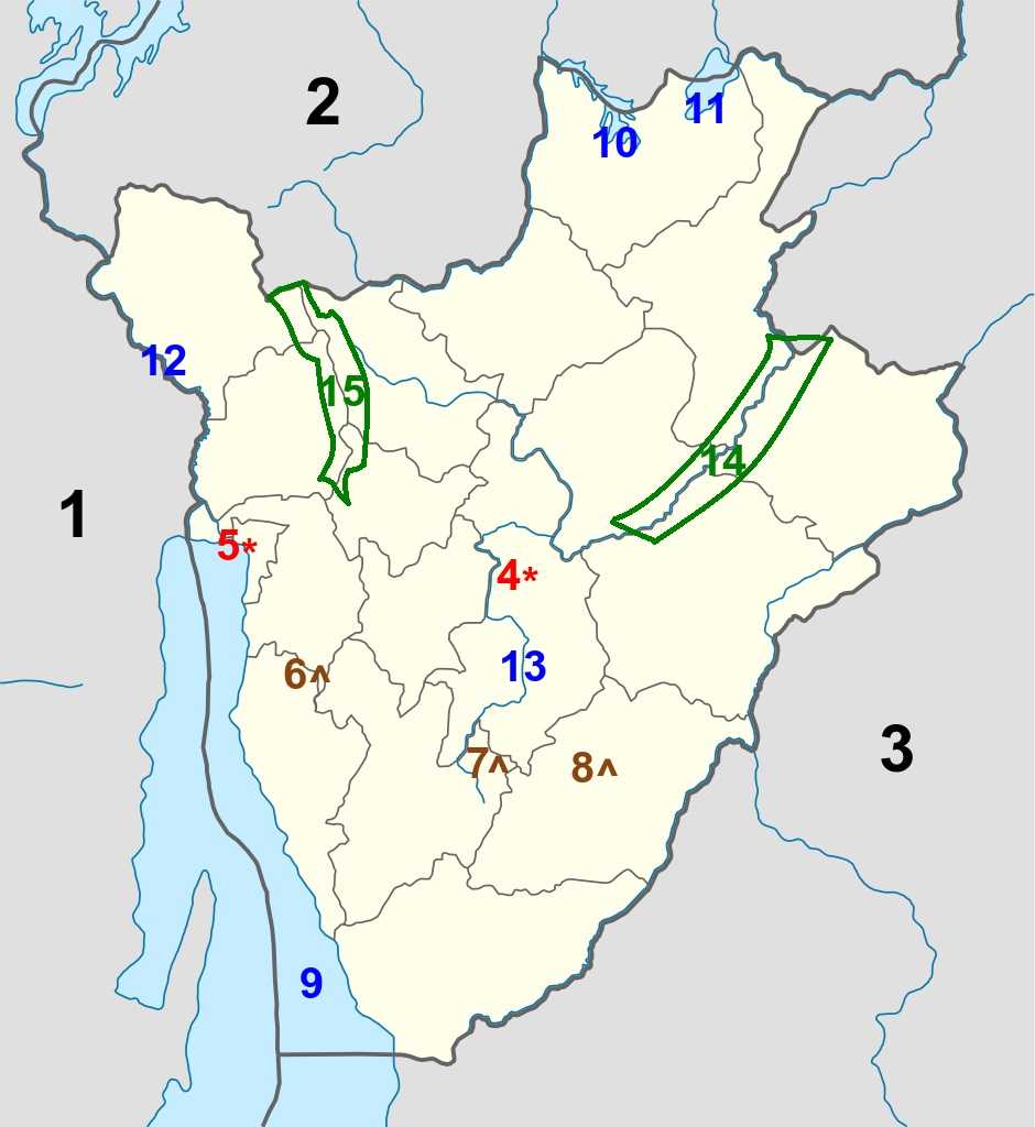
Burundi is one of Africa's smallest countries, and also one of the world's poorest. Do you know where it is on the continent, and what are some of its prominent geographical features?

A label quiz by reedy. Estimated time: 4 mins.
  1. Home
  2. »
  3. Quizzes
  4. »
  5. Geography Trivia
  6. »
  7. Africa
  8. »
  9. Burundi

Author
reedy
Time
4 mins
Type
Label Quiz
Quiz #
408,358
Updated
Mar 10 22
# Qns
15
Difficulty
Average
Avg Score
10 / 15
Plays
630
Last 3 plays: tkny (4/15), matthewpokemon (15/15), ZWOZZE (11/15).
Nyakazu Fault Lake Cohoha DR Congo Mount Heha Lake Tanganyika Tanzania Yuvyironza River Kagera Waterfalls Kibira National Park Ruvubu National Park Gitega Rwanda Lake Rweru Bujumbura Ruzizi River
* Drag / drop or click on the choices above to move them to the answer list.
1. 2nd largest African country  
2.   
3. Home of Mt. Kilimanjaro  
4. Capital city  
5. Largest city  
6. Highest elevation  
7. AKA 'German's Gorge'  
8.   
9. Lowest elevation  
10.   
11. Translates as 'White Lake'  
12. Congo River watershed  
13. Southernmost source of the Nile  
14.   
15. Congo-Nile Divide  

Most Recent Scores
Mar 13 2024 : tkny: 4/15
Mar 13 2024 : matthewpokemon: 15/15
Mar 13 2024 : ZWOZZE: 11/15
Mar 13 2024 : George95: 13/15
Mar 13 2024 : BarbaraMcI: 11/15
Mar 13 2024 : MrNobody97: 15/15
Mar 13 2024 : spidersfull: 9/15
Mar 13 2024 : fado72: 15/15
Mar 13 2024 : blackavar72: 5/15

Quiz Answer Key and Fun Facts
1. DR Congo

The Democratic Republic of the Congo lies to the west of Burundi, and the two countries share a 236 km (147 mi) land border extending north from Lake Tanganyika. And they also share a portion of Lake Tanganyika, albeit very different proportions (the DRC claims 45% of the long lake, while Burundi only has the northernmost section along the country's western flank (for approx. 161 km / 100 mi).
2. Rwanda

Rwanda lies to the north of Burundi, sharing a border for 315 km (196 mi). The two countries are roughly the same size, (Burundi is slightly bigger); they are the 5th and 4th smallest on the African mainland, with the only smaller ones being Djibouti (3rd), Eswatini (2nd) and The Gambia (smallest).

The Kingdom of Rwanda existed from the 15th century until the region came under colonial rule; both Rwanda and Burundi came under the rule of the German Empire in 1897 as part of 'German East Africa.' Belgium took control of the region in 1916 during World War I, and was subsequently granted control by the League of Nations in 1922. Rwanda and Burundi were thrust together as the colony of Ruanda-Urundi from then until 1946, when the United Nations made Ruanda-Urundi into a 'Trust Territory,' with the promise from Belgium that they would prepare the territory for independence. In 1961, the name of the territory was changed to Rwanda-Burundi.

Other factors combined to bring about the independence of Rwanda-Burundi in 1962 (a little earlier than Belgium was planning), and the territory divided along traditional lines as the Republic of Rwanda and Kingdom of Burundi (Burundi would follow suit four years later, becoming the Republic of Burundi).
3. Tanzania

Tanzania shares a 589 km (366 mi) border with Burundi, extending to the northeast from Burundi's southernmost point (along Lake Tanganyika eastern shore) until the border with Rwanda is reached.

The United Republic of Tanzania was established in 1964 when Tanganyika and Zanzibar merged, and the unified country has been part of the British Commonwealth since even before that (Tanganyika was a member since 1961, and Zanzibar from 1963).

In 1967, six countries (Burundi, Rwanda, Tanzania, Kenya, South Sudan, and Uganda) formed the East African Community. It lasted until 1977, then was revived in the year 2000, providing a common market for goods, labour, and capital within the region.
4. Gitega

Burundi's political capital city Gitega is located in the middle of the country, on the Burundian central plateau (at an elevation of 1,504 m (4,934 ft)). For much of the Kingdom of Burundi's existence (since the late 17th century), Gitega was the seat of power for the mwamis who ruled. When Germany (and subsequently, Belgium) took control of the region, Gitega remained an administrative center for the colonial powers. Following Burundi's independence from Belgium in 1962 and its transition to a republic in 1966, the capital was moved to the city of Bujumbura on the shore of Lake Tanganyika.

Leadership of the Republic of Burundi has been a difficult prospect, as there have been assassinations and coups, stemming from political and tribal unrest, largely between the Hutu (85%) and Tutsi (15%) ethnic groups.

In 2007, President Pierre Nkurunziza announced that the capital would return to Gitega, but nothing official would occur until parliamentary assent was given in early 2019. In 2022, according to worldpopulationreview.com, the population of Bujumbura stood at 23,167.
5. Bujumbura

The village of 'Usumbura' existed prior to the arrival of colonial powers, and after the Germans laid claim to the region, they established a military outpost at the site, located where the Ruzizi River met Lake Tanganyika. In 1916, when Belgium took over the region and created the mashed-together colony of Ruanda-Urundi, they also moved the capital from Gitega to Usumbura.

With the reestablishment of Burundi as an independent nation, Usumbura's name was changed to Bujumbura, and with its location on the lake (for transport and trade), continued to grow to become the economic hub of the country. In 2019, the government moved back to the traditional and more centralized site of Gitega.

In 2022, according to worldpopulationreview.com, the population of Bujumbura stood at 331,700.
6. Mount Heha

Mount Heha lies within the Burundi Highlands, rising to an elevation of 2,684 m (8,806 ft). It is located in the Bujumbura province, about 30 km southeast of the city of Bujumbura. It is a very accessible peak for trekkers, not requiring any specialized equipment.
7. Nyakazu Fault

The Nyakazu Fault is a chunk out of the Nkoma Massif, which extends southeast towards the Tanzania border and overlooks the southern plains of Burundi. The site was also called the 'German's Gorge' as they built a fort there, and also fought against advancing Belgian forces there in 1916.

It is a breathtaking sight, covering an area of 600 hectares (about 2.3 sq miles), opening into the Kumoso Depression. The region became a protected area in 1980, and was submitted for consideration as a UNESCO World Heritage site in 2007.
8. Kagera Waterfalls

The Kagera Waterfalls are the other part of the submission for UNESCO World Heritage site status, along with the Nyakazu Fault. They are located in the Rutana Province, and are divided into six branches over three levels, two of which have a drop of 80m (262 ft), with the third one at a height of 50 m (164 ft).

As with the Nyakazu Fault, the Kagera Waterfalls were designated a protected area in 1980.
9. Lake Tanganyika

Lake Tanganyika is shared between four countries, with Burundi touching the northernmost portion along its eastern shore. The other countries bordering the lake are the Democratic Republic of the Congo, Tanzania, and Zambia.

Lake Tanganyika is the second-largest lake (by area) in Africa after Lake Victoria, is the second-deepest lake in the world (after Lake Baikal in Russia), and is the longest lake in the world, extending 676 km (420 mi) north to south along the Albertine Rift, with an average width of 50 km (31 mi).

The lake is one of the most biodiverse in the world, with more than 2,000 different species. According to the World Conservation Union, "no place on earth holds such a variety of life."
10. Lake Cohoha

Lake Cohoha straddles the border between Burundi and Rwanda, where it is called Lake Cyohaha South (there is a Lake Cyohaha North in Rwanda, as well). It is roughly half and half between the two countries, comprising about 74 km2 (30 sq mi) in total area.

Lake Cohoha is called 'Mother Cohoha' for how it is the provider of life (water) and freshness during dry seasons.
11. Lake Rweru

Lake Rweru also straddles the border between Burundi and Rwanda, quite near the northernmost point of Burundi. It is a very shallow lake, with an average depth of 2.1 m (7 ft), and it covers an area of 100 km2 (39 sq mi), with the majority (80%) of the lake on the Burundian side.
12. Ruzizi River

Much of the 1,140 km (708 mi) worth of Burundi's land border follows rivers, and the Ruzizi river is one of those. It rises in Lake Kivu (one of the Great Lakes), flowing south for 117 km (73 mi) to empty into Lake Tanganyika at the city of Bujumburu. Along the way, it forms the border between DR Congo and Rwanda before continuing with the same role between DR Congo and Burundi.

Unlike most of the majority of Burundi's waterways (on the east side of the Burundian Highlands), the Ruzizi River is part of the Congo River watershed, as the waters of Lake Tanganyika flow out along the Lukuga River, then west to the Lualaba River, which is a major tributary of the Congo River.

One famous resident of the Ruzizi River and the northern banks of Lake Tanganyika is Gustave, a large crocodile (described in 2002 as being more than 5.5 m (18 ft) long, and weighing more than 910 kg (2,000 lbs) that has supposedly killed more than 300 people. His story was told in the 2004 film "Capturing the Killer Croc."
13. Yuvyironza River

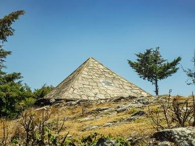
There is more than one source of the Nile River, depending on the factors being considered, but the Yuvyironza River has the distinction of being the one that is located the furthest south. Rising from a spring on Mount Kikizi (and marked with a monument as the source of the Nile), the Yuvyironza River extends for 182 km (113 mi) before joining the Ruvubu River (near the capital city of Gitega), which later joins the Kagera River in Tanzania.

The Kagera River flows into Lake Victoria, out of which flows the Nile River.
14. Ruvubu National Park

Ruvubu National Park is Burundi's largest national park, with an area of 508 km2 (196 sq mi). The Ruvubu River flows along its entire length as it passes along four provinces (Karuzi, Muyinga, Cankuzo and Ruyigi) before reaching the border with Tanzania.

Established in 1980, the park is the last remaining part of a formerly vast natural grassland ecosystem, and is known for its diversity of flora and fauna, including 400 species of bird, five primate species, and the expected hippopotamuses, Nile crocodiles, Cape buffalo, waterbucks, and duikers.
15. Kibira National Park

Once a hunting reserve for Burundian kings, today's Kiriba National Park was transformed into the 'Congo-Nile Ridge Forest Reserve' by the colonial Belgian government in 1933. In 1980, the Burundian government further protected the region as a national park to prevent deforestation.

It is located in the northwestern region of the country, covering an area of 400 km2 (154 sq mi) and extending to the border with Rwanda, and is contiguous with Rwanda's Nyungwe National Park.
Source: Author reedy

This quiz was reviewed by FunTrivia editor agony before going online.
Any errors found in FunTrivia content are routinely corrected through our feedback system.
Related Quizzes
This quiz is part of series Mixing It Up (3):

My third set of ten quizzes in the 'new' formats of labeling, ordering, and classifying. Have fun playing!

  1. Alphabetical America, Part Four Very Easy
  2. The Brink of War Average
  3. Locating Burundi Average
  4. South Africa's Three Capitals Average
  5. Alphabetical America, Part Five Very Easy
  6. A Timeline for British Columbia Average
  7. Who Did That? Very Easy
  8. Flock Together Average
  9. Celestial Order Average
  10. East or West? Easier

4/18/2024, Copyright 2024 FunTrivia, Inc. - Report an Error / Contact Us