FREE! Click here to Join FunTrivia. Thousands of games, quizzes, and lots more!
Australia - In the Middle Trivia Quiz
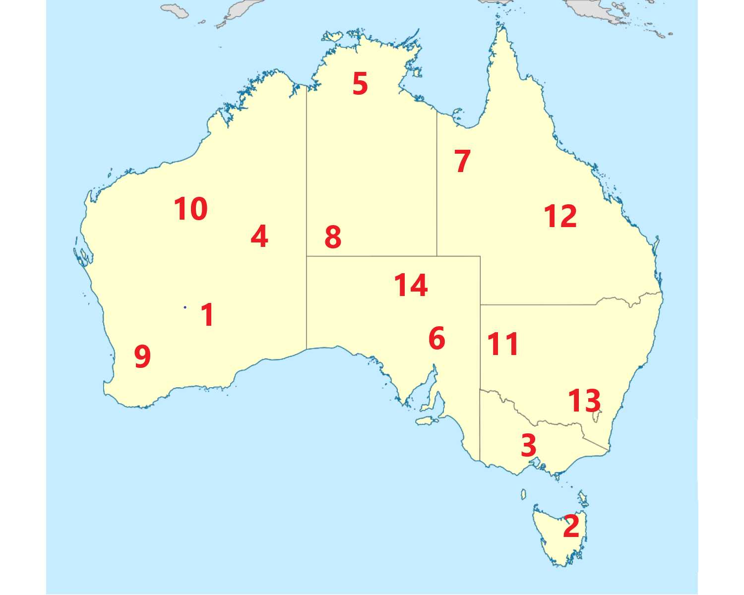
Most of Australia's best known cities and towns are on the coast, but what do you know about inland? Locate the places and geographical features which aren't quite so close to the sea on the map. Australia is large, so I've included fourteen places. This is a renovated/adopted version of an old quiz by author Quacker
Last 3 plays: JanIQ (1/14), Strike121 (3/14), GoodwinPD (14/14).
Match the listed name to its numbered location on the map. The numbers are in the general area rather than having pinpoint accuracy.
Click on image to zoom
EvandaleGibson DesertBroken HillBallaratYorkMount KosciuszkoKatherineUluruMount Isa Kati Thanda-Lake EyreKalgoorlieCoober PedyMount MeharryCarnarvon Gorge* Drag / drop or click on the choices above to move them to the answer list. View Image Attributions for This Quiz
Western Australia is very large, so there are four places marked there. At number one is Kalgoorlie, usually now called Kalgoorlie-Boulder as a merger between the two cities took place in 1989. The growth came about because of the gold rush of 1893 with Kalgoorlie deriving its name from an Aboriginal word for a local plant, Gold mines are still operational in the region, with nickel another important mineral found in the general area.
Kalgoorlie-Boulder lies just under 400 miles (600 km) from Perth and Australia's largest desert; the Great Victoria Desert is located to the east.
2. Evandale
Finding inland in Tasmania is a little harder as most of the best known places are coastal. Evandale is in the northern part of the island and is named for an explorer and surveyor named George Evans. Settlement in the region began in the early nineteenth century, helped by its location on the South Esk River. Many of the buildings date from that period, dating from the early days of Queen Victoria's reign.
Evandale is situated about 11 miles (18 km) south of the much bigger city of Launceston. The state capital, Hobart, is much further south.
3. Ballarat
Victoria also has only one representative in the quiz, in the form of Ballarat. This is another city which owes its growth and prosperity to gold, with the precious metal being found there in 1851. The city also received its name from an Aborigine language with the translation being 'resting place'. By population, Ballarat is one of Australia's largest inland cities. Historically, it's where the uprising called the 'Eureka Stockade' took place in 1854.
Ballarat also has a university, which has its origins in the School of Mines established in 1870. As distances go in Australia, Ballarat is relatively near the coast and is only around 70 miles (115 km) from Melbourne, with Geelong even closer.
4. Gibson Desert
We're back to Western Australia for this desert, which is situated between the Great Sandy Desert to the north and the Great Victoria Desert to the south. It is classed as a nature reserve, but is not a major tourist destination, being so remote. The terrain consists of arid sandhills and spinifex grass which provides homes for many animals including several types of snake and lizards, including the thorny devil. The name comes from a member of an exploration party led by Ernest Giles in the 1870s. The unfortunate Gibson disappeared while searching for water.
To reach the Gibson Desert from Perth is a distance of over 1,300 miles (2,200 km).
5. Katherine
The town of Katherine is situated in Northern Territory and lies on the Katherine River. The name was given to both in the 1860s by a Scottish explorer who chose it to honour the daughter of one of the sponsors who funded the expedition. Nearby, especially when speaking of Australian distances, is the Katherine Gorge, which has spectacular shades of quartzite. It now forms part of the Nitmiluk National Park and is 22 miles (35 km) from the town.
Katherine is located to the southeast of Darwin at a distance of around 170 miles (270 km), almost on the doorstep compared to many inland locations.
6. Kati Thanda-Lake Eyre
Situated in South Australia, Lake Eyre, as it was known in English, is a large, saltwater lake which was first found by an English explorer in 1840, after whom the lake was originally named. The name was officially changed in 2012 to recognise and include the Aboriginal name. The lake is the lowest part of the Australian mainland, with its lowest point being 50 feet (15 metres) below sea level. It is not a lake normally, as it is often completely dry due to the high temperatures in the region.
From Adelaide to Lake Kati Thanda-Lake Eyre is a distance of about 435 miles (700) in a northward direction.
7. Mount Isa
The city of Mount Isa is in Queensland, in the northwestern part of the state, inland from the Gulf of Carpentaria. The discovery of mineral deposits in 1923 led to its foundation, with the name coming from the name of Isabella, a sister of John Campbell Mills, who found them. The region became a big producer of copper, zinc, lead and silver, although copper mining operations ceased in 2025 after becoming nonviable financially.
Since Brisbane is located in the southeast, the distance between the state capital of Queensland and Mount Isa is huge at around 1,000 miles (1,600 km). Driving would take nearly a whole day, but flying is the preferred option.
8. Uluru
Uluru, long known in English as Ayers Rock, is about as close to the middle of Australia as anything in this quiz. It's also the cover photo I chose as being possibly the first place many of us think of as being Australian. It is situated in the south of Northern Territory closer to Western Australia and Southern Australia than to Darwin, the state capital. Uluru is a monolith, meaning made from just one type of stone which is sandstone, giving it its reddish shade which is enhanced by the sun especially as it sets. The site is sacred to the Aboriginal people and climbing the rock was banned in 2019.
Uluru is over 900 miles (around 1,500 km) from Darwin. Even the closest town of Alice Springs is nearly 300 miles (470 km) away.
9. York
Although it's not as far inland as most of the other places in this quiz, York is included as it has the honour of being the oldest town in Western Australia which is not on the coast. It was first settled in 1831, a year after it was given its name, chosen because the area reminded explorer J S Clarkson of his home region of Yorkshire in England. The town was the centre for farming, both of animals and grains, and also benefitted from the gold rush as it was one of the final stops before prospectors reached the goldfields - they had to walk the rest of the way.
It is relatively close to Perth at a distance of just over 60 miles or 100 kilometres.
10. Mount Meharry
Mount Meharry is Western Australia's tallest mountain at about 4,100 feet (1,250 m). The name comes from a surveyor of the region, who identified the mountain as the highest in the state. It forms part of the Hamersley Range and is located in the northwest of Western Australia. The region is known for its iron ore deposits.
Perth lies much further south, so it is quite a distance from the mountain at about 750 miles or 1,200 in km.
11. Broken Hill
We visit New South Wales now for Broken Hill, another place which primarily owes its existence to mining. It is nicknamed the 'Silver City', although silver is only one of the elements found there - the region is also endowed with rich supplies of the ores from which lead and zinc are made. The famous explorer Charles Sturt first visited the region in 1844, deriving the name from the shape of the range of hills. The origins of the city began in 1883 when silver was found.
Broken Hill is only 30 miles (50 km) from the border with South Australia, so the distance from the state's capital of Sydney is huge at over 700 miles (nearly 1,200 km).
12. Carnarvon Gorge
We stay in Queensland for this location, which is situated in the central part in the Carnarvon National Park, named for the Carnarvon Range, part of the Great Dividing Range of hills and mountains. The gorge has examples of rock art. The Carnarvon Creek is one of the water sources. Rainfall and wind erosion formed the gorge, which is mainly sandstone. The region also has Aboriginal rock carvings and an abundance of wildlife to see.
From Brisbane to Carnarvon Gorge is over 450 miles (730 km), so rather more than an easy day trip.
13. Mount Kosciuszko
Australia's highest mountain is part of the Snowy Mountains in the Australian Alps, in the southeastern part of New South Wales. Its name honours a Polish statesman as the explorer to 'find' it, Paul Strzelecki, came from Poland. His exploration of the region took place in 1840. There are several peaks of over 7,000 feet (2,100 m) but Kosciuszko is the tallest at 7,310 feet (2,200 m). The whole area is now a national park, named after the mountain.
The mountain is 240 miles (390 km) southwest of Sydney.
14. Coober Pedy
Coober Pedy is situated centrally in South Australia, and is another town to owe its growth to the mining industry. In this case, the product is opals with most of the world's supply originating here, although the original prospectors were looking for gold. As with other place names in the quiz, the name is a corruption of the Aboriginal name, 'kupa piti', said to mean either a watering hole or 'white man in a hole'. Most of the dwellings in the town are underground due to the scorching temperatures, which make it a tourist destination.
Coober Pedy is around 600 miles (950 km) from Adelaide, the state capital.
This quiz was reviewed by FunTrivia editor agony before going online.
Any errors found in FunTrivia content are routinely corrected through our feedback system.