FREE! Click here to Join FunTrivia. Thousands of games, quizzes, and lots more!
Quiz about Mapping Australia

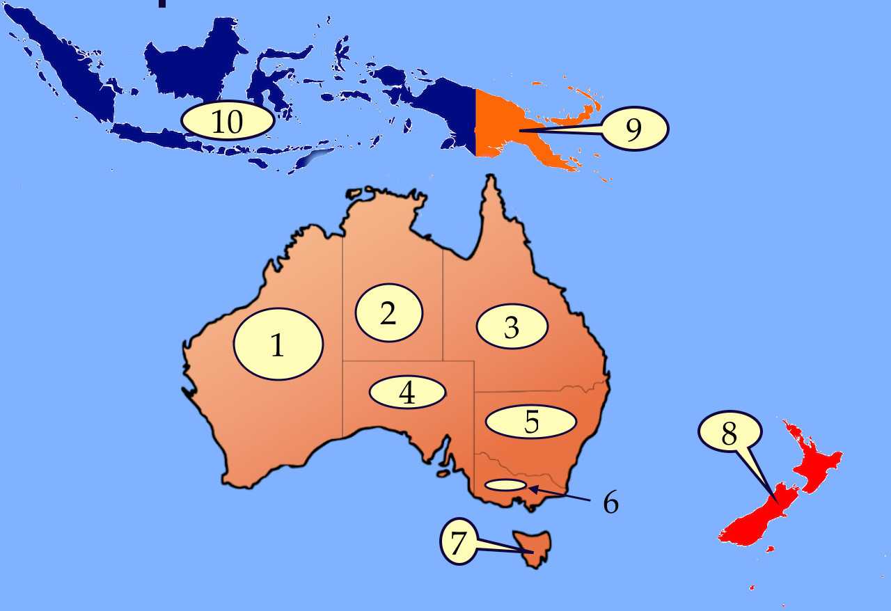
Mapping Australia Trivia Quiz


Test your knowledge of Australia and its nearest neighbors by putting the correct labels on the map. Includes six states, one mainland territory, and three nearby countries. Good luck.

A label quiz by gracious1. Estimated time: 3 mins.
  1. Home
  2. »
  3. Quizzes
  4. »
  5. Geography Trivia
  6. »
  7. Australia

Author
gracious1
Time
3 mins
Type
Label Quiz
Quiz #
407,897
Updated
Jan 16 22
# Qns
10
Difficulty
Very Easy
Avg Score
9 / 10
Plays
1120
Awards
Top 10% Quiz
Last 3 plays: Guest 1 (10/10), Guest 101 (8/10), SimonySeller (10/10).
Note: Map may not be drawn entirely to scale.
New Zealand Victoria Western Australia Papua New Guinea Indonesia Tasmania Northern Territory South Australia Queensland New South Wales
* Drag / drop or click on the choices above to move them to the answer list.
1.   
2.   
3.   
4.   
5.   
6.   
7.   
8.   
9.   
10. largest Muslim country  

Most Recent Scores
Apr 18 2024 : Guest 1: 10/10
Apr 16 2024 : Guest 101: 8/10
Apr 11 2024 : SimonySeller: 10/10
Apr 11 2024 : Kat1982: 5/10
Apr 10 2024 : Linda_Arizona: 10/10
Apr 09 2024 : Guest 81: 6/10
Apr 06 2024 : Guest 14: 10/10
Apr 05 2024 : matthewpokemon: 10/10
Apr 04 2024 : Guest 47: 10/10

Quiz Answer Key and Fun Facts
1. Western Australia

Australia's largest state, Western Australia borders the Indian Ocean and (to the north) the Timor Sea. Mountains rise in the west, and in the center are deserts called the Gibson and the Great Victoria. The highest peak in Western Australia is Mount Meharry. The northern part of the state has essentially two season, wet and dry, but the southwest has four seasons, though the winters are mild and the summers are breezy. Most people live in the southwestern part of the state, where you'll find the capital city of Perth.

Shark Bay, about 500 miles (800 kilometers) north of Perth, is a UNESCO World Heritage site because of its enormous seagrass beds which are home to one-tenth of the world's dugongs (sea cows). Shark Bay also has a lot of rock-like structures called stromatolites, an important source of some of the earliest fossils in Earth's natural history.
2. Northern Territory

One of Australia's most famous symbols, a red rock called Uluru (Ayers Rock) is in the Northern Territory. Although the territory is huge, only 1% of Australians live there. Around 200,000 people live in the Northern Territory. Half live in the capital city of Darwin, and about a quarter have Aboriginal roots (and mainly live in rural areas). The two most important industries in the Northern Territory are tourism and mining. In the ground are gold, silver, zinc, uranium, oil, natural gas, and bauxite, which is used to make aluminium (or "aluminum" in North America). The red kangaroo and the wedge-tailed eagle are the official animals.

A territory belongs to a country but hasn't the same rights as a state. The Northern Territory is the only territory besides the Australian Capital Territory (an enclave within New South Wales) on continental Australia. Several of Australia's other territories are islands, including the Coral Sea Islands, Christmas Island, and Norfolk Island.
3. Queensland

Nicknamed the Sunshine State, Queensland has sandy beaches, damp rainforests, great open plains, and rugged highlands. The Great Dividing Range (of mountains) rises in the middle of the state, and the Great Barrier Reef, the world's largest coral reef, is off Queensland's Pacific coast. About 40% of the residents live in the capital, Brisbane.

Queensland is Australia's second-largest state, but it has the greatest animal diversity. While Aboriginals were living in Queensland for 40,000 years, Europeans first explored the area in the late 18th century. Britain operated prison camps in Queensland between 1824 and the early 1840s. Queensland was originally a part of New South Wales until 1859, after gold had been discovered and miners flocked to the colony.
4. South Australia

In the 1600s, the Dutch were the first to reach what is now South Australia (inhabited by Aboriginal people for 23,000 years or more). British explorer Matthew Flinders visited the area around 1802. When South Australia first became a state in 1901, it included the Northern Territory, which split off in 1911.

In mostly flat and low South Australia (SA) are some of the driest and emptiest regions of Australia, especially as you travel inland. The northeastern part of the state is part of the Great Artesian Basin, which is the world's largest area of natural springs (water that rises from underground). The state's only major river is the Murray. Farmers grow grapes, vegetables, oranges, wheat, and barley. In fact, the state produces most of Australia's wine (and a great deal of wool). Iron, salt, and gypsum are mined there. too. About three-quarters of the people live in the capital city of Adelaide. SA is one of the world's greatest sources of opal, the birthstone for October. The hairy-nosed wombat is the official state animal.
5. New South Wales

The capital of New South Wales (NSW) is Sydney, the largest city in Australia, and there you will find the unique Sydney Opera House, built to look like sails or shells. Australia's longest river, the Darling, is in NSW. So is Australia's highest peak, Mt. Kosciuszko, about 100 miles (160 kilometers) southwest of Canberra, the nation's capital. Two other important rivers are the Murray and the Murrumbidgee. NSW manufactures more goods than any other Australian state, and most of Australia's zinc, lead, and silver are mined in NSW.

It is called New South Wales because when explorer James Cook first saw the area in 1788, it reminded him of South Wales. You might expect, then, that the flag of NSW would have a red dragon (a symbol of Wales), but actually it has a golden lion as most of the European settlers were from England, not Wales. The colony of New South Wales became a state when Australia became an independent country in 1901 (though the borders were not set until 1915).
6. Victoria

Victoria is the second-smallest state in area, but the second-largest in population. The Murray River forms most of its border with New South Wales. The western part of the state has deserts, while the northeast and central parts have mountains. The largest city in Victoria and the second-largest in all of Australia is Melbourne, the capital of Victoria and the state's cultural and industrial center. Farmers grow a variety of crops including celery, lettuce, and potatoes, and there are numerous sheep and cattle ranches. Fossil fuels are found in Victoria, too.

In 1770 James Cook was the first British explorer to visit what is now Victoria, though Aboriginal people were living there for 40,000 years or more. There were, unfortunately, a number of wars between the Europeans and the Aborigines, whose population declined from 20,000 to 3,500 by 1850. Victoria was originally part of the colony of New South Wales, but it split away in 1851 and became a state in 1901.
7. Tasmania

The smallest state of Australia is Tasmania, which occupies a triangle-shaped island about 150 miles (240 kilometers) south of the state of Victoria. There are other islands, too, such as Bruny and Flinders. The main island is mostly plateau, meaning it is flat and raised, though there are mountains in the west. Mount Ossa, peaking at 5,305 feet (1,617 meters), is Tasmania's highest point. Tasmania's Lake Saint Clair, over 700 feet deep (or 215 meters deep), happens to be Australia's deepest lake. The state's largest city is also the capital, Hobart, and the main port.

Of course, Tasmania is home to the fierce Tasmanian devil, a meat-eating marsupial. This creature usually does not attack livestock but prefers dead sheep, yet if it's hungry enough it will go after live animals. Nor will it shy from defending itself against animals much larger than itself. (And it really looks a little like Taz, the Tasmanian devil of Looney Tunes, though smaller.)
8. New Zealand

Sail a thousand miles (1600 kilometers) southeast from Australia, and you will run into the country of New Zealand. The two main islands of the country of New Zealand are (conveniently) the North Island and the South Island. Mount Cook, the country's tallest peak stands on the South Island, while its longest river, the Waikato, flows on the North Island. New Zealand has lots of fjords (narrow fingers of water with steep, cliff-like banks), and lots of sheep! There are also plenty of fruit bats and flightless birds, including the penguin and the kiwi, which is New Zealand's symbol (and what New Zealanders call each other).

Auckland is the largest city in New Zealand, and it was the capital until Wellington took over in 1865. New Zealand was originally settled by the Maori, a Polynesian people. Europeans began settling in the 19th century. In the 21st century, the Maori remain a larger part of the population of New Zealand than do the Native Americans of the USA or the Aboriginal peoples of Australia.

(Polynesia is a region of islands in the Pacific and part of a multi-national region called Oceania. Australia and New Zealand are also part of Oceania.)
9. Papua New Guinea

The country of Papua New Guinea (PNG) takes up the eastern half of the island of New Guinea. PNG is only about 92 miles or 150 kilometers from the tip of Australia. A small Australian island called Kussa is only one kilometer (or a little over a thousand yards) from the coast of PNG!

Papua New Guinea has gold and copper mines, but most folks are farmers or farmworkers. Important crops include coffee, cocoa, bananas, coconuts, and sweet potatoes. Animals in PNG (and actually the whole island of New Guinea) include wallabies and tree-kangaroos, which are in the same family as kangaroos and wallabies, but they look more like possums and live in trees. There are also egg-laying mammals called echidnas (or spiny anteaters).

Most people in the country belong to one of two ethnic groups: Papuan and Melanesian. As you might guess from the country's name, the Papuan group is larger and lives on the island of New Guinea. The Melanesians live among the surrounding islands. Melanesia is an island region that includes Fiji, the Solomon Islands, Vanuatau, and the Torres Strait Islands (which belong to the state of Queensland, Australia) as well as the island of New Guinea.
10. Indonesia

Indonesia consists of tens of thousands of islands. Four of the five biggest islands are Sumatra, Java, Sulawesi, and Kalimantan. The fifth island, New Guinea, is shared with the country Papua New Guinea. Indonesia's province on this island is known as Papua (not to be confused with the country of Papua New Guinea). While Indonesia is generally seen as a part of Southeast Asia, many geographers consider the island of New Guinea to be a part of Oceania, along with Australia and New Zealand and the Pacific Islands further east.

The Dutch colonized Indonesia starting in the early 16th century. Japan wrested Indonesia from the Dutch in 1942, although after World War II it returned to Dutch control. Indonesia became fully independent in 1949.

Indonesia has many, many active volcanoes, including the infamous Krakatoa (or Krakatau), which is part of a chain of volcanoes in the Pacific known as the Ring of Fire. Most of Indonesia is tropical rainforest, with areas of swamps and mangrove trees. Found in the earth in Indonesia are copper, nickel, silver, gold, and other minerals. Major crops include sugar, coffee, coconuts, and natural rubber. There are tigers, rhinos, and elephants to be found, but peacocks roam only on the island of Java.
Source: Author gracious1

This quiz was reviewed by FunTrivia editor agony before going online.
Any errors found in FunTrivia content are routinely corrected through our feedback system.
4/19/2024, Copyright 2024 FunTrivia, Inc. - Report an Error / Contact Us