FREE! Click here to Join FunTrivia. Thousands of games, quizzes, and lots more!
Quiz about Picturing Quebec

Picturing Quebec Trivia Quiz


Quebec is the main French speaking province of Canada, and also the largest province by size. This quiz explores the province with carefully chosen picture clues to help.

A photo quiz by rossian. Estimated time: 4 mins.
  1. Home
  2. »
  3. Quizzes
  4. »
  5. Geography Trivia
  6. »
  7. Canada
  8. »
  9. Quebec

Author
rossian
Time
4 mins
Type
Photo Quiz
Quiz #
373,843
Updated
Dec 03 21
# Qns
10
Difficulty
Average
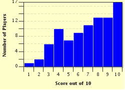
Avg Score
8 / 10
Plays
774
Awards
Top 20% Quiz
Last 3 plays: Guest 99 (0/10), crossesq (9/10), psnz (10/10).
-
Question 1 of 10
1. Quebec borders four American states. Maine, New Hampshire and New York are three of them, but which is the fourth? Hint


Question 2 of 10
2. Quebec's highest mountain lies on its border with Labrador, and is known by different names in the two provinces: Mount d'Iberville in Quebec and Mount Caubvick in Labrador. In which mountain range is it situated? Hint


photo quiz
Question 3 of 10
3. 'La fête nationale' is celebrated in Quebec on 24th June to honour which saint, who is the province's official patron saint? Hint


Question 4 of 10
4. These woods are located on the Isle of Montreal and form part of the largest wetland on the island. What is their name? Hint


photo quiz
Question 5 of 10
5. Located in the Mauricie, this large city was founded in 1634 based on the recommendation of the explorer Samuel de Champlain. It is named for a geographical feature of its location, and includes which French number? Hint


Question 6 of 10
6. Waskaganish is a former trading post of the Hudson's Bay Company, located on James Bay. The settlement has had several names, but which of them was taken from the name of the river which flows past it into James Bay? Hint


photo quiz
Question 7 of 10
7. Situated in Old Montreal is a market which originally opened for trading in 1847. It was named for a nearby chapel, although the name versions are slightly different. By what name is the market known? Hint


Question 8 of 10
8. Quebec City is located on a promontory in the Saint Lawrence River. What is its name in English? Hint


photo quiz
Question 9 of 10
9. Quebec has a great deal of natural water, including many man made reservoirs. Which lake is, by surface area, the largest naturally formed lake in Quebec? Hint


Question 10 of 10
10. The Plains of Abraham, located in The Battlefields Park, can be found in which of these cities? Hint


photo quiz

(Optional) Create a Free FunTrivia ID to save the points you are about to earn:

arrow Select a User ID:
arrow Choose a Password:
arrow Your Email:


View Image Attributions for This Quiz

Most Recent Scores
Sep 12 2024 : Guest 99: 0/10
Sep 11 2024 : crossesq: 9/10
Aug 27 2024 : psnz: 10/10
Aug 27 2024 : jonnowales: 5/10
Aug 20 2024 : TurkishLizzy: 10/10
Aug 15 2024 : Guest 156: 7/10
Aug 12 2024 : bernie73: 5/10
Jul 26 2024 : Cinnamon6: 6/10
Jul 24 2024 : Luckycharm60: 10/10

Score Distribution

quiz
Quiz Answer Key and Fun Facts
1. Quebec borders four American states. Maine, New Hampshire and New York are three of them, but which is the fourth?

Answer: Vermont

Quebec is the largest province of Canada - Nunavut is larger, but is a territory. Quebec borders Ontario, Newfoundland and Labrador and New Brunswick in Canada, and also has borders on Hudson Bay, Ungava Bay, Hudson Strait, James Bay and the Gulf of Saint Lawrence. Most inhabitants live in the part of the province, around the Saint Lawrence river. Montreal, the largest city, and Quebec City, the capital, are both located in this area.

The four US states obviously border the southern part of Quebec. Vermont itself was originally a French possession, and its name has its roots in the French language. Mont Vert would translate to Green Mountain, and is the reason I gave you the green coloured hint in the photo.
2. Quebec's highest mountain lies on its border with Labrador, and is known by different names in the two provinces: Mount d'Iberville in Quebec and Mount Caubvick in Labrador. In which mountain range is it situated?

Answer: Torngat

The Torngat Mountains are located on the Labrador Peninsula and cover parts of Quebec, Labrador and Nunavut. The name comes from the Inuktitut language and translates into English as 'the home of the spirits'. Mount d'Iberville is the highest mountain of the mainland of eastern Canada, and is 5,240 feet (1,652 metres) high. It is the highest mountain in both Quebec and Newfoundland and Labrador, with the latter claiming the most lofty part, since the peak lies on their side of the border.

The picture clue shows a piece of paper with the corner torn off, which may have helped.
3. 'La fête nationale' is celebrated in Quebec on 24th June to honour which saint, who is the province's official patron saint?

Answer: John the Baptist

Also known as Saint-Jean-Baptiste Day, the tradition arrived with the French and has been adopted by Quebec, and other parts of Canada and the USA, as a celebration of French Canadian culture. The day, which is also Midsummer's Day, is an official public holiday and celebrations include bonfires, concerts, fireworks and parades.

The photo clue shows some honey, since the Bible tells us that John the Baptist lived on locusts and honey. I thought you'd prefer honey to locusts, both to look at and, definitely, as food.
4. These woods are located on the Isle of Montreal and form part of the largest wetland on the island. What is their name?

Answer: Angell Woods

Angell Woods cover approximately 250 acres (100 hectares) and are just under 60% privately owned, with the rest in public ownership in the early part of the twenty-first century. The woods are situated to the west of the city of Beaconsfield, which is a dormitory area, or commuter town, for people who work in Montreal. Their name derives from the original owners, not from any heavenly bodies.

The photo clue is meant to depict an angel. I included 'Sky' and 'Halo' as options, although these are made up names as regards Canadian woods. Allegheny Highlands Forest is real, though.
5. Located in the Mauricie, this large city was founded in 1634 based on the recommendation of the explorer Samuel de Champlain. It is named for a geographical feature of its location, and includes which French number?

Answer: Trois

The city is Trois-Rivières, meaning three rivers, a name which dates from 1599. It is situated at the point where the Saint-Maurice river joins the Saint Lawrence river. Islands in the Saint-Maurice divide it into three distinct parts at this point, from which the name derived. Although de Champlain suggested the location in 1603 the settlement was actually founded by the Sieur de Laviolette who is commemorated by a bridge named for him and a bust created in 1934, the city's three hundredth anniversary.

The photo is of a series of triangles to point you towards the number three.
6. Waskaganish is a former trading post of the Hudson's Bay Company, located on James Bay. The settlement has had several names, but which of them was taken from the name of the river which flows past it into James Bay?

Answer: Fort-Rupert

The river was named by Henry Hudson in honour of Prince Rupert, who was the governor of the Hudson's Bay Company. The trading post was established at the river's mouth in 1668, and was renamed as Fort-Saint-Jacques during the period of French occupation, between 1686 and 1713. The people living there in the twenty-first century are mainly of Cree Indian descent, and the name of Waskaganish, meaning 'little house', comes from the Cree language.

The photo shows a model of Rupert Bear, who first appeared in comic strips in 1920.
7. Situated in Old Montreal is a market which originally opened for trading in 1847. It was named for a nearby chapel, although the name versions are slightly different. By what name is the market known?

Answer: Bonsecours

The market is located in rue Saint-Paul and has a long history as a market and as a place to hold exhibitions and banquets. It also housed various government officials in its earlier years. It narrowly escaped demolition in the 1960s although it has been protected since 1984 as a National Historic Site of Canada. The church from which it took its name is Notre-Dame-de-Bon-Secours, which dates from 1771.

Bon secours translates as 'good help' - the church is 'Our Lady of Good Help', hence the clue. Bonne chance is good luck. Bon courage has a similar meaning, but is used when the task is particularly difficult. Bon marché literally means good market - we had a shop called that where I grew up, but it wasn't pronounced the French way.
8. Quebec City is located on a promontory in the Saint Lawrence River. What is its name in English?

Answer: Cape Diamond

Cape Diamond, or Cap Diamant in French, was named by Jacques Cartier in 1535 from the belief that the stones he could see in the cliffs were diamonds, although they were actually quartz. The city grew from two forts set up by Samuel de Champlain. The first, now the lower town, was founded in 1608 while a second fort was built at the top in 1620. It became the provincial capital in 1791 and designated as a city in 1832. The city's name is officially just Quebec, but City is normally added to differentiate it from the province.

The photo was meant to guide you to the shape of the wire, not the colour, and from there to the correct answer.
9. Quebec has a great deal of natural water, including many man made reservoirs. Which lake is, by surface area, the largest naturally formed lake in Quebec?

Answer: Lake Mistassini

The lake was discovered by European explorers in 1672, with Charles Albanel being credited as the first Frenchman to see it. The lake is around 900 square miles (2,330 square km) in area and is situated in the Nord-du-Québec region. Its name means 'large rock' in the indigenous languages of the region, and various spellings have been used over the years. The spelling used for the question was established in the late nineteenth century.

Although all the lakes listed can be found in Quebec, I chose a photo of trees shrouded in mist for your additional clue.
10. The Plains of Abraham, located in The Battlefields Park, can be found in which of these cities?

Answer: Quebec City

The Plains of Abraham were the site of a decisive battle in 1759, between Britain and France, for the control of the region. The troops were led by James Wolfe for the British and the Marquis de Montcalm on the French side, and neither man survived the battle. The British occupied Quebec City, and Canada became a British possession under the Treaty of Paris, signed in 1763. The Battlefields Park was opened in 1908 and has memorabilia relating to the battle.

The picture is of the flag of Quebec City, which was adopted in 1987. The ship depicted represents that of Samuel de Champlain, the founder.
Source: Author rossian

This quiz was reviewed by FunTrivia editor spanishliz before going online.
Any errors found in FunTrivia content are routinely corrected through our feedback system.
Related Quizzes
This quiz is part of series Geography Mix:

These are geography quizzes that don't fit in either the UK series or the 'Lost in' series.

  1. A Child's Eye View of South America Very Easy
  2. Also Known As Average
  3. Around Europe From Tree to Tree Average
  4. Barbados Average
  5. Destination Denmark Average
  6. Exploring the World Easier
  7. Following in Famous Footprints Average
  8. Go For Gin Average
  9. Help Me, I'm Lost Easier
  10. Legends of Canada Average
  11. Picturing Quebec Average
  12. The Beautiful Island of Sri Lanka Average

9/18/2024, Copyright 2024 FunTrivia, Inc. - Report an Error / Contact Us