FREE! Click here to Join FunTrivia. Thousands of games, quizzes, and lots more!
Quiz about East Coast Tour Part II

East Coast Tour: Part II Trivia Quiz


In the summer of 2011, a friend and I went on a twenty-one day road trip to the East Coast of Canada. Here is the second leg of our trip. I hope you enjoy the tour!

A photo quiz by apathy100. Estimated time: 5 mins.
  1. Home
  2. »
  3. Quizzes
  4. »
  5. Geography Trivia
  6. »
  7. Canada
  8. »
  9. Newfoundland

Author
apathy100
Time
5 mins
Type
Photo Quiz
Quiz #
390,367
Updated
Dec 03 21
# Qns
10
Difficulty
Average
Avg Score
7 / 10
Plays
207
Awards
Top 35% Quiz
-
Question 1 of 10
1. During the second part of our trip, my friend and I left Gros Morne National Park. As we drove along the Trans-Canada Highway through Newfoundland, we saw plenty of traps being stored along the side of the highway. What was the purpose of these traps? Hint


Question 2 of 10
2. In Bishop's Falls, Newfoundland, is an old railway trestle that was converted to a walking path. The Labrador region uses railway mainly for mining operations near the Quebec border. Does Newfoundland proper continue to operate a railway system?


Question 3 of 10
3. Just outside of Gander was a monument dedicated to the victims of a major crash on December 12, 1985. What were the circumstances of this crash? Hint


Question 4 of 10
4. Continuing our journey along Highway 1 we stopped into Gambo, Newfoundland, the birthplace of Canada's "last Father of Confederation". What popular politician was dubbed this nickname? Hint


Question 5 of 10
5. After staying the night at Frenchman's Cove, we traveled to the small town of Fortune, Newfoundland to catch the ferry to St. Pierre and Miquelon. To do so, we drove across land that while rocky was mildly hilly but mainly flat.
Which of the following peninsulas would we have driven across to get to the ferry?
Hint


Question 6 of 10
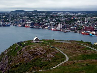
6. After we had returned from St. Pierre and Miquelon (which will be saved for a quiz all unto its own), we arrived in Newfoundland's capital city of St. John's. On a foggy, dreary, cooler day we visited Canada's most easterly point. During the Second World War, this site was used by the Canadian military as a gun battery. What is this easterly point called? Hint


Question 7 of 10
7. Most of the time we were in the Newfoundland capital city, the weather just wouldn't let up. We decided to tour the sites within an hour of the city so we checked out the community of Harbour Grace known for its fishing and military history. There was quite the monument that honors early aviation pioneers such as Amelia Earhart and Thor Solberg. What is the name of this monument? Hint


Question 8 of 10
8. In 1866, a cable was brought across the Atlantic Ocean and into Heart's Content, Newfoundland providing the first transatlantic communication from Europe to North America. In 1965, the Heart's Content Cable Station was closed for the last time due to which of the following technologies becoming obsolete? Hint


Question 9 of 10
9. Just prior to leaving the province of Newfoundland, we stopped at the remains of the Castle Hill fortifications that overlook Placentia Bay. In the 1600s, these fortifications were initially established by the French in order to protect which of the following industries? Hint


Question 10 of 10
10. At Argentia, Newfoundland we drove the truck aboard a passenger and vehicle ferry to embark on a 12-hour ride across what body of water, that landed us at North Sydney, Nova Scotia? Hint


(Optional) Create a Free FunTrivia ID to save the points you are about to earn:

arrow Select a User ID:
arrow Choose a Password:
arrow Your Email:


View Image Attributions for This Quiz

Most Recent Scores
Mar 29 2024 : Allons-y: 8/10
Feb 29 2024 : DCW2: 10/10

Quiz Answer Key and Fun Facts
1. During the second part of our trip, my friend and I left Gros Morne National Park. As we drove along the Trans-Canada Highway through Newfoundland, we saw plenty of traps being stored along the side of the highway. What was the purpose of these traps?

Answer: They are lobster traps

Also known as "lobster pots", the lobster trap has been integral to the economy of Newfoundland for over a hundred years. The traps typically have either a wooden or metal frame and are split into two parts. The "chamber" is used to place bait to entice the lobster while the "parlour" is an enclosure within the trap where the lobster cannot escape. Once baited, the traps are typically dropped to the sea floor and then marked with a buoy. Canadian lobster fishing is Canada's most valuable seafood export with nearly 80% going to the United States.

Other major markets for exports include Japan, China and France. The Avalon Peninsula marks some of the key communities for lobster fishing in Newfoundland including the communities of Placentia Bay and Arnold's Cove.
2. In Bishop's Falls, Newfoundland, is an old railway trestle that was converted to a walking path. The Labrador region uses railway mainly for mining operations near the Quebec border. Does Newfoundland proper continue to operate a railway system?

Answer: No

In 1880, it was recommended that a narrow-gauge railway be constructed across the Newfoundland territory. It would become the longest narrow-gauge railway in North America. This railway system would be built in portions throughout the years and would eventually connect St. John's to Port-Aux-Basques, a distance of over 1400 kilometers. Throughout the majority of its existence, the railway companies faced constant economic struggles including the bankruptcy of the Newfoundland Railway Company in the late 1800s.

During both World Wars, train traffic increased as a means to assist in various military construction operations. These operations included the construction of an air force base at Gander, British and Canadian defense facilities at St. John's, and American military bases at Stephenville, Argentia and St. John's. The railway included a ferry system to allow a connection to the mainland in Canada.

After Newfoundland became an official province of Canada in 1949, the railway system became operated and repaired by the crown corporation Canadian National (CN). The construction of the Canso Causeway in Nova Scotia in 1955 allowed for an easier railway link between the two provinces. By the 1970s, however, with an increased need for bus and truck transportation, the use of the railway system declined severely.

By 1979, the need for a railway cargo system ultimately became completely unnecessary and all branch lines across the province were officially shut down by 1984. By 1986, one of the two railcar ferries linking Newfoundland to Nova Scotia was sold and as a result limited the exchange and interchange abilities in both provinces. On October 1, 1988 the last official train to run commenced its journey at Bishop's Falls.
3. Just outside of Gander was a monument dedicated to the victims of a major crash on December 12, 1985. What were the circumstances of this crash?

Answer: An airline crash

Tragically, Arrow Air Flight 1285 crashed shortly after takeoff killing all 256 passengers and crew on board. The flight was transporting U.S. troops returning from Egypt and was scheduled to land at Fort Campbell near the Kentucky/Tennessee border. It is believed that icing conditions along with possible pilot error were contributing factors that led to the plane crash.

In 1990, a statue was dedicated with many people in attendance as a tribute to the United States 101st Airborne Division. The statue depicts two innocent children and an unarmed soldier. The memorial includes the American, Canadian and Newfoundland flags. A tall cross is situated near the statue. Surrounded by a forested area, this site has become known as the "Silent Witness Memorial". On December 12, 1995, ten years after the crash, a memorial service was held by representatives of the Canadian and American military to honor the victims of the crash.
4. Continuing our journey along Highway 1 we stopped into Gambo, Newfoundland, the birthplace of Canada's "last Father of Confederation". What popular politician was dubbed this nickname?

Answer: Joey Smallwood

When Newfoundland became an official province in 1949, Joey Smallwood became the first premier in the history of the province and remained there unchallenged for 23 years, when he lost the 1972 election to Frank Moores. Prior to his time as a politician, Smallwood worked for various newspapers and even operated a pig farm in the 1940s.

While the premier of Newfoundland, he was very popular due to his willingness to stand up to union bosses and militant persons. He was successful in promoting various industries in Newfoundland including mining, paper mills and hydroelectricity.

He was known for keeping a tight ship of ministers within his cabinet going so far as to not providing a "question period" during the House of Assembly. After he was defeating during the 1972 election, he took many of his political followers and formed the Newfoundland Reform Liberal Party.

Unfortunately, he was unable to gain a following with his new party and they would dissolve officially in 1979. After he retired from politics, he spent most of his retirement writing and publishing various books.

He died in 1991 just shy of his 91st birthday.
5. After staying the night at Frenchman's Cove, we traveled to the small town of Fortune, Newfoundland to catch the ferry to St. Pierre and Miquelon. To do so, we drove across land that while rocky was mildly hilly but mainly flat. Which of the following peninsulas would we have driven across to get to the ferry?

Answer: Burin Peninsula

Located on the south coast of Newfoundland, the Burin Peninsula separates Fortune Bay in the west from Placentia Bay in the east. Formed from sedimentary and igneous rock, the peninsula is slightly hilly with minimal elevation. Located at the edge of the Burin Peninsula, Cape Chapeau Rouge is its highest point with an elevation of just 226 meters above sea level. Due to its low elevation, this region of Newfoundland thrived with cod fisheries as an economy until the 1990s when the Atlantic northwest cod fishery went into economic collapse.
6. After we had returned from St. Pierre and Miquelon (which will be saved for a quiz all unto its own), we arrived in Newfoundland's capital city of St. John's. On a foggy, dreary, cooler day we visited Canada's most easterly point. During the Second World War, this site was used by the Canadian military as a gun battery. What is this easterly point called?

Answer: Cape Spear

With the exception of the Danish-controlled region of Greenland, Cape Spear is the eastern-most point of the continent of North America. Historically, it was initially settled by the Beothuk people but was not permanently inhabited due to their non-sedentary lifestyle.

In 1836, the Cape Spear Lighthouse was finalized and has been in operation ever since. Various improvements on the lighthouse have taken place including the addition of a fog horn in 1878 and use of electricity for lighting in 1930.

It was designated a National Historic Site in 1962.
7. Most of the time we were in the Newfoundland capital city, the weather just wouldn't let up. We decided to tour the sites within an hour of the city so we checked out the community of Harbour Grace known for its fishing and military history. There was quite the monument that honors early aviation pioneers such as Amelia Earhart and Thor Solberg. What is the name of this monument?

Answer: Spirit of Harbour Grace

During the 1920s, trans-Atlantic aviation began to take hold in full force. Some popular pioneers in the aviation industry including Amelia Earhart and Thor Solberg used this location as a means to cross the Atlantic on route to Europe. In 1931, a prototype for the DC-1 aircraft was developed by the Douglas Aircraft Corporation. By 1935, the DC-3 was manufactured and was dubbed the "aircraft that changed the world".

The Spirit of Harbour Grace was a DC-3 built in 1943 for the purpose of serving action with the United States Air Force during the African Campaign. During the war, the community of Harbour Grace was used by the Canadian military for both naval and air force purposes. Following the war, it was purchased by a variety of companies and owners where it finally lay in the hands of Roger Pike, a native of Harbour Grace.

He would use the plane as a private owner to transport food, mail and other goods and retired the plane for good in 1988. The Pike family donated the plane to the community of Harbour Grace in 1993 to showcase its rich history of aviation.
8. In 1866, a cable was brought across the Atlantic Ocean and into Heart's Content, Newfoundland providing the first transatlantic communication from Europe to North America. In 1965, the Heart's Content Cable Station was closed for the last time due to which of the following technologies becoming obsolete?

Answer: Telegraph

In 1866, the SS Great Eastern brought the first trans-Atlantic cable across the ocean from Valentia Island, Ireland to Heart's Content. Following several failed attempts to do so in the 1850s, under the captaincy of Sir James Anderson, 4200 kilometers of cable was laid across the Atlantic.

The first official communication was made using Morse code. By the First World War, over 200 people from Heart's Content were employed at the cable station. As more automated forms of communication were being developed, the need for the Morse code and the cable station had dwindled by the Second World War. With the emergence of trans-Atlantic telephone cables and satellite technology in the 1940s and 1950s, the station was officially closed in 1965.
9. Just prior to leaving the province of Newfoundland, we stopped at the remains of the Castle Hill fortifications that overlook Placentia Bay. In the 1600s, these fortifications were initially established by the French in order to protect which of the following industries?

Answer: Fisheries

Castle Hill is an area near the current town of Placentia that was once used by both the French and the British to built fortifications. The area was used during three different wars; King William's War (1688-97), Queen Anne's War (1702-13), and Father Rale's War (1722-25).

Initially established to protect French fisheries in the area from invading countries, it was later used as a stronghold for territorial reasons. In 1968, the area was declared a National Historical Site. Presently, visitors to the site can see excavated and unexcavated remains of various elements including walls, Fort Royal, British blockhouse and the Horseshoe Battery.
10. At Argentia, Newfoundland we drove the truck aboard a passenger and vehicle ferry to embark on a 12-hour ride across what body of water, that landed us at North Sydney, Nova Scotia?

Answer: Cabot Strait

The history of the Atlantic Marine ferry service between Newfoundland and Nova Scotia dates back to 1898 when the first vessel crossed between Port-Aux-Basques, Newfoundland and North Sydney, Nova Scotia. On July 1, 1898, the SS Bruce delivered a group of passengers for the very first time arriving just before midnight. Since this initial voyage, the Marine Atlantic service is an integral part of both transportation and communication between Newfoundland and the Canadian mainland. The ferries not only carry passengers, but are equipped to hold motor vehicles including cars, trucks and tractor trailer units. Until the 1986, the ferries were also equipped to carry railway cars as well.

From 1928 to 1942 the SS Caribou was the main ferry providing services between Port_Aux-Basques and North Sydney but ultimately had a tragic ending during the Second World War. As German submarines were patrolling the Gulf of the St. Lawrence, they saw the heavy smoke from the passenger ship. At approximately 3:50 AM on October 14, 1942, the SS Caribou was torpedoed by German submarine U-69. As there were 73 civilians on board, many women and children lost their lives that day. In all, 137 people perished as a result of the damage of which 49 were civilians.
Source: Author apathy100

This quiz was reviewed by FunTrivia editor agony before going online.
Any errors found in FunTrivia content are routinely corrected through our feedback system.
4/26/2024, Copyright 2024 FunTrivia, Inc. - Report an Error / Contact Us