FREE! Click here to Join FunTrivia. Thousands of games, quizzes, and lots more!
Quiz about Identify the Provinces and Territories of Canada

Identify the Provinces and Territories of Canada Quiz


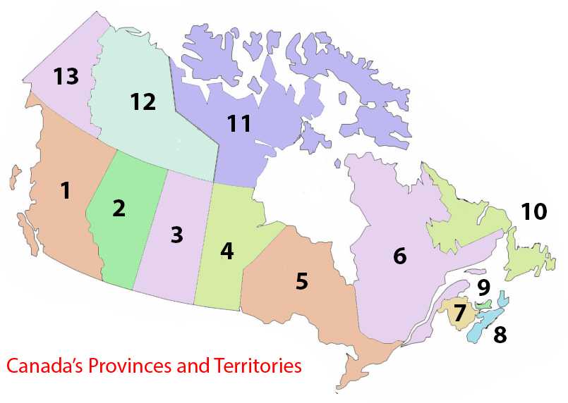
Can you correctly label the provinces and territories on a map of Canada? In this new quiz format we use a single image to act as a guide for the questions.

A label quiz by Terry. Estimated time: 3 mins.
  1. Home
  2. »
  3. Quizzes
  4. »
  5. Geography Trivia
  6. »
  7. Canada

Author
Terry
Time
3 mins
Type
Label Quiz
Quiz #
407,657
Updated
Sep 25 22
# Qns
13
Difficulty
Easy
Avg Score
11 / 13
Plays
1852
Awards
Top 5% quiz!
Last 3 plays: Guest 174 (2/13), Guest 96 (13/13), oldgrannyk (13/13).
All of the provinces and territories are shown below. Try to label them all.
New Brunswick Manitoba British Columbia Quebec Yukon Newfoundland and Labrador Nova Scotia Saskatchewan Ontario Prince Edward Island Alberta Northwest Territories Nunavut
* Drag / drop or click on the choices above to move them to the answer list.
1.   
2.   
3.   
4.   
5.   
6.   
7.   
8.   
9.   
10.   
11.   
12.   
13.   

Most Recent Scores
Apr 24 2024 : Guest 174: 2/13
Apr 23 2024 : Guest 96: 13/13
Apr 23 2024 : oldgrannyk: 13/13
Apr 21 2024 : Guest 145: 2/13
Apr 20 2024 : boon99: 13/13
Apr 20 2024 : Guest 66: 11/13
Apr 20 2024 : bgjd: 11/13
Apr 19 2024 : Guest 50: 5/13
Apr 18 2024 : misdiaslocos: 13/13

Quiz Answer Key and Fun Facts
1. British Columbia

B.C. is the westernmost province of Canada, with most of the population concentrated in the southwestern corner, in the greater Vancouver area and the southern tip of Vancouver Island. The interior is mainly mountainous, with many long narrow finger lakes stretching north/south. It's Canada's most diverse province, with many different ethnic groups and languages represented.
2. Alberta

Alberta is the westernmost of the prairie provinces, with the Rocky Mountains forming most of the western border. The fossil fuel industry has been important in Alberta since coal mining started in the late 1800s, with petroleum and natural gas dominating in the second half of the 20th century. Alberta is unusual for having had very stable provincial governments - the Social Credit Party formed the government from 1935 - 1971, and the Progressive Conservatives from 1971 - 2015.
3. Saskatchewan

Saskatchewan, the middle prairie province, is often seen by outsiders as flat and featureless, but that's only if you never leave the Trans-Canada highway! The northern half of the province is boreal forest, while in the south are features such as the Great Sand Hills, and the Cypress Hills, which are a rarity in Canada because of never being covered by glaciers.
4. Manitoba

Manitoba is the easternmost of the prairie provinces. Nearly half of the province is forested, with the southern part being prairie, and tundra in the northeast. The city of Churchill, on Hudson's Bay, is famous for the polar bears that can be found there. Just outside of Winnipeg is the longitudinal centre of Canada - the mid point between east and west.
5. Ontario

Ontario, which stretches north from the Great Lakes, is Canada's most densely populated province, and contains the largest city, Toronto. It also contains the nation's capital, Ottawa. The province can be roughly divided into Northern Ontario, in the rocky, wooded Canadian Shield, and Southern Ontario, along the Great Lakes and Ottawa River, where most of the people live.
6. Quebec

Quebec is Canada's largest province, with most of the people living along the St Lawrence River in the south. Originally the chief colony of New France, it became a British colony after the French and Indian Wars, but was allowed to keep many of its civil customs, rights, and language, which has an enormous impact upon the future development of Canada. French is the only official language of the province, and the vast majority of the people in Quebec speak French.
7. New Brunswick

New Brunswick is one of the Maritime provinces. Initial European settlement was French, with much of the province being in the Acadian district of New France. New Brunswick is the only Canadian province that is officially bilingual with English and French. Its most striking natural feature is probably the Bay of Fundy, with the world's highest tidal range of about 16 metres.
8. Nova Scotia

Nova Scotia, in the Maritimes, is the second smallest Canadian province, with roughly half of the population living in the Halifax area. Halifax Harbour is one of the largest ice free natural harbours in the world, and, in 1917, suffered what is still the largest man-made accidental explosion, when the ship Mont-Blanc exploded and killed nearly 2,000 people, injuring thousands more. Advances in eye care, pediatric surgery, and several other medical reforms arose from the aftermath of the disaster.
9. Prince Edward Island

P.E.I. is the smallest and most densely populated of the Canadian provinces, sitting in the Gulf of St Lawrence. It was host to the Charlottetown Conference that led to Canadian Confederation in 1867, but P.E.I. did not join Canada itself until 1873. High iron oxide levels give the soil its colour - it really is "bright red mud" as the song says.
10. Newfoundland and Labrador

Newfoundland and Labrador is Canada's easternmost province, and probably the first to experience European contact - there is evidence of a Norse settlement in L'Anse aux Meadows from around 1000CE. Labrador, on the Canadian mainland, became part of the Dominion of Newfoundland in 1927, while Newfoundland and Labrador as a whole joined Canada in 1949. Newfoundlanders have a reputation for being the friendliest, and the funniest, Canadians.
11. Nunavut

Nunavut is the newest territory in Canada, formed from the eastern section of the Northwest Territories. It's the largest of the territories, and includes most of the Arctic islands. The earliest European exploration of the area was in search of the Northwest Passage. Nunavut has three official languages - English, French, and Inuktitut.
12. Northwest Territories

The Northwest Territories are the central of Canada's three northern territories. Yellowknife, N.W.T.'s capital and only city, has roughly half of the population of the territory. Canada's longest river system, the Mackenzie, along with the deepest lake in North America, the Great Slave, are in the Northwest Territories.
13. Yukon

Yukon, the westernmost of the territories, is also the smallest, and has the smallest population of any of the provinces and territories. It split off from the Northwest Territories at the time of the Klondike Gold Rush, in 1898. Mount Logan, the highest peak in Canada, is in Yukon, in the Saint Elias range.
Source: Author Terry

This quiz was reviewed by our editing team before going online.
Any errors found in FunTrivia content are routinely corrected through our feedback system.
4/25/2024, Copyright 2024 FunTrivia, Inc. - Report an Error / Contact Us